oldsaigon
Old Saigon
We are residents of Saigon who enjoy photographing the remnants of the city's historical architecture. All pictures posted here are original.
If you are interested in submitting original photos to post, please contact us using Twitter (@Old_Saigon); due credit for photos will be given.
70 posts
Don't wanna be here? Send us removal request.
Last Seen Blogs

vernavirtue1-blog
Rumored Buzz on details Subjected

zulhelmy33
Untitled

b7ral8na-blog
Untitled

alvistem
alvi

jpdrawsalot
saltier than the effing ocean
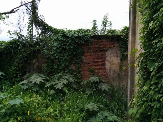
Photo


Photoset 2: details and interior shot A follow-up gallery with a few more details of this amazing historic house in Long Xuyên.
1 note
·
View note
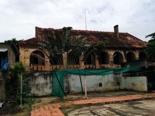
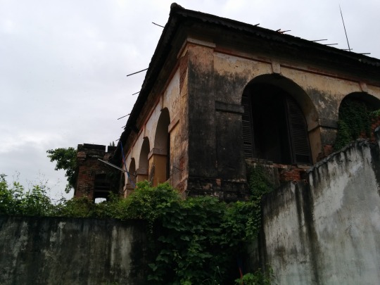
Photo
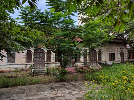


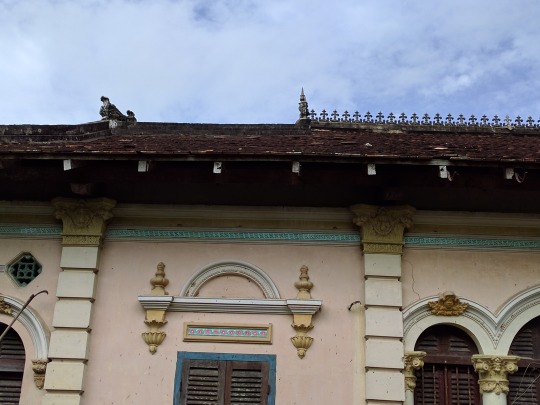
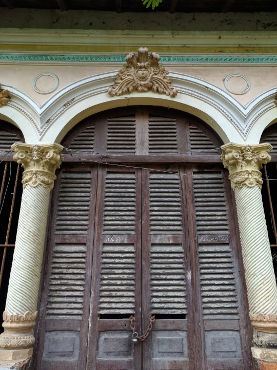
Photoset 1: exterior shots. We were back in Long Xuyen for a visit and a friend told us about this historic house located right smack dab in the middle of town near a popular park. I lived in Long Xuyen for five years and never heard about this place or saw it. The place is hidden behide a row of cafes, and the entrance is through a place where an old man sells coffee. The coffee seller's grandfather built the house in 1926, he told me. He went on to elaborate that the house was confiscated by the government in 1975 and was only recently returned to the family. The house sits empty now except for when death anniversaries or other family events take place. If you go there to take pictures, the old man asks that you buy a cup of coffee for 10,000 VND (less that $0.50), and I was only too happy to oblige.
3 notes
·
View notes
Photo

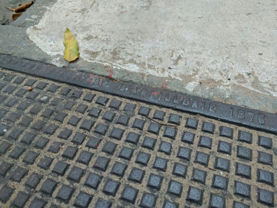
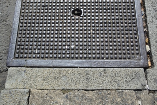
I was walking downtown last month, and happened to glance down at an old sewer cover, looking for the "Saigon Direction D'Artillerie" text that I've been spotting around town. However, for the first time, I saw some different text. The imprint on this one reads: Saigon Construction Navales, with a date in the 1870s (the last digit is very worn out).
After consulting with Google Translate, the French "Construction Navales" is "shipbuilding" in English, thus likely placing the origin of this sewer cover in the historic Ba Son Shipyard. Sadly, Ba Son is in the midst of destruction in the name of progress, and relics such as this worn out piece of steel from the 1870s may be all that remain of one of the most historic areas in the city.
This particular sewer/manhole cover is located on Mạc Thị Bưởi Street, between Nguyễn Huệ Boulevard and Đồng Khởi Street.
#Old Saigon#Old Vietnam#Historic Saigon#Historic Vietnam#Ho Chi Minh City#Saigon Shipbuilding#Saigon Construction Navales#1870s
5 notes
·
View notes
Photo

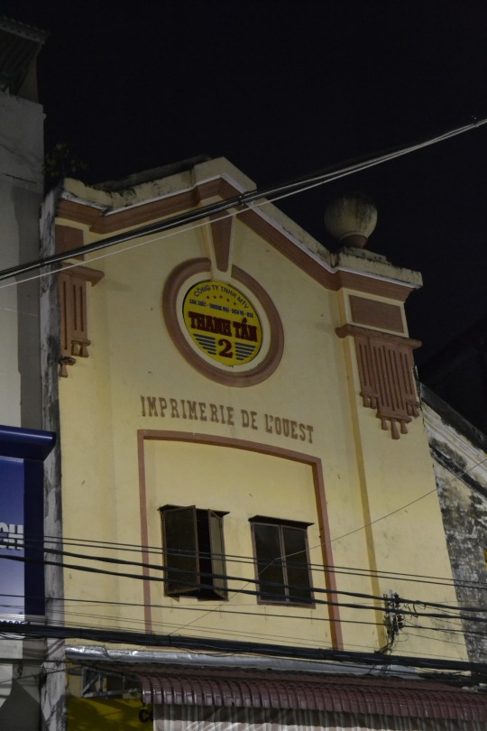
I snapped these photos well over a year ago while spending a weekend in Cần Thơ. The "Imprimerie de L'ouest," or Western Publishing House lettering is still clearing visible on this historic building in the downtown area.
Interestingly, if you have $500 to spare, you can buy a book that was published here on rice cultivation in Indochina published in 1933 (in French, of course).
Also, just with a quick Google search I found a reference to another book published here a year earlier, in 1932.
2 notes
·
View notes
Photo
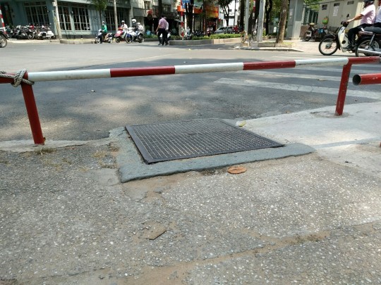
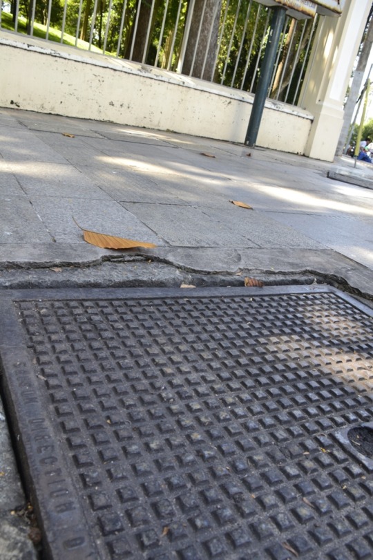
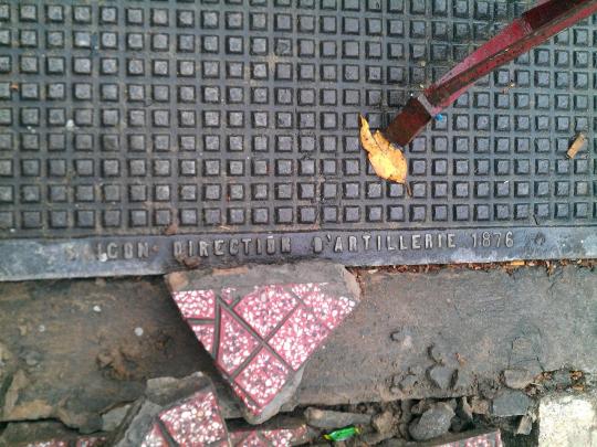
Another manhole/sewer cover in downtown Saigon bearing the half worn out words: Saigon Direction D'Artillerie 1876. This particular one is at the corner of Hàn Thuyên and Pasteur Streets.
1 note
·
View note
Photo
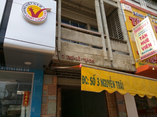
Old Long Xuyên I visited Long Xuyên this past weekend and had been meaning to take a photo of this for some time. The current name of the street is Nguyễn Trãi, but when the building was constructed, it was Đại Lộ Tự Do, or Freedom Boulevard. A name like that would fit right in stateside.
1 note
·
View note
Photo
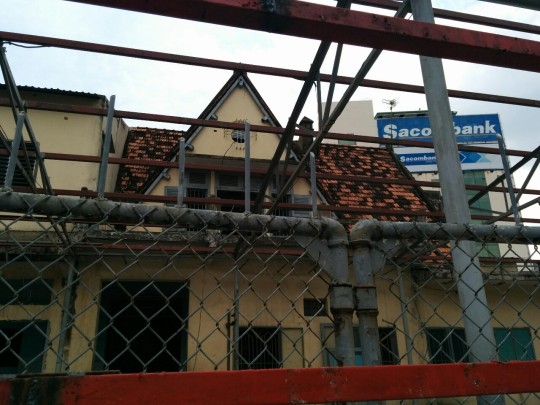

I spotted this unique looking structure on Lý Chính Thắng Street, not far from Năm Kỳ Khởi Nghĩa Street. The first thing that struck me about this building was the steep pitch of the roof. However, the day I passed by, they were building a fence in front of it, something that usually does not bode well for historic buildings in this town.
4 notes
·
View notes
Photo


A few pictures of manhole covers in downtown Saigon that bear the text "Saigon Direction D'Artillerie" and a range of dates in the 1870s. I found all of these by chance after stumbling upon one back in August 2012. The dates on these are older than any original building that I've heard of in Saigon. Especially interesting is the fact that they are located near Notre Dame Cathedral and the Saigon Central Post Office, two buildings that are considered some of the oldest in the city. The two maps that are included feature the Direction D'Artillerie located what is now Tôn Đức Thắng Street, near the Saigon River. And of course there's a little map if you'd like to check out these manhole covers yourself. I have looked around in other areas of downtown Saigon, but these are the only manhole covers that I've found so far that have the text "Saigon Direction D'Artillerie." If you see any more of these, be sure to take pictures and let us know. You never know how long something old will remain in this town. For the complete set of pictures and more details, head on over to Ngân's blog. All photos posted are by Tạ Mỹ Ngân.
#Old Saigon#Historic Saigon#Ho Chi Minh City#Manhole Cover#Saigon Direction D'Artillerie#1870s#History
4 notes
·
View notes
Photo

Glimpses of Old Saigon are everywhere in this city. An interesting thing about the CEE (Compagnie des Eaux et Electricte) substations is that many of them retain street names from before 1975. This particular one is located off of Nam Kỳ Khởi Nghĩa Street. The former name of the street was Công Lý, or justice, as can be seen in the picture.
6 notes
·
View notes
Photo


Sometimes I just go into the Saigon Post Office and stare at these maps. I could probably stare at them all day.
7 notes
·
View notes
Photo
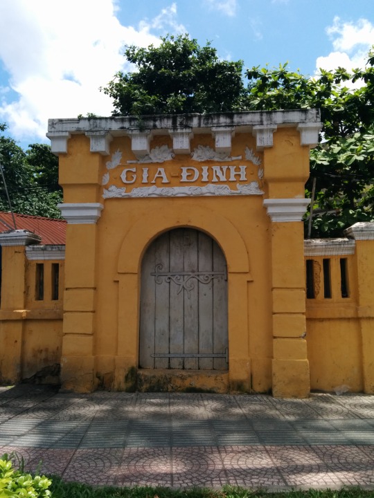
This structure is located on the corner of Đinh Tiên Hoàng and Phan Đăng Lưu streets in Bình Thạnh District. As to what the purpose of this structure, I have no idea. It looked historic and decently maintained, so I stopped and snapped a picture.
Also, my Southern Vietnamese history is a bit rusty, but I seem to remember that all of Saigon and environs was once called Gia Định, then what is now downtown was named Saigon, with the outer areas/districts still known as Gia Định. Perhaps this structure is from that era. Any other insights/guesses into the origin of this interesting structure?
2 notes
·
View notes
Photo
Hello Saigon! Glad to be back! I saw this article posted on Thanh Niên last week about an old fort up in Biên Hòa and simply had to get up there to see it. Biên Hòa is about an hour's drive from downtown Saigon on a motorbike, along highways crammed with container trucks, dump trucks and buses. It's a slightly harrowing and very dusty drive, but after chilling at a riverbank cafe upon arrival, we were off to the fort. The roof and upper story of the building are easily seen from the road. However, the best views were from inside a government courtyard (Ban Quản lý Di tích và Danh thắng Đồng Nai) and the guy at the gate would not grant us (two foreigners and one Vietnamese) access. "Talk to the director," the guy said, curtly.
We snapped what photos we could from the street, then went down an alley and followed a muddy path where garbage collectors park their cyclos. There was a half destroyed building that looked like it was formerly a nhà trọ or something. The place was overgrown and we gingerly walked around in our flip-flops and found the side wall to the fort, characteristically made from colonial French era solid bricks, as opposed to the "air bricks" so popular in contemporary Vietnam. We wanted to see more, but just couldn't access a good viewing location. I'd love to go back with a proper letter of introduction to take in more of this glorious old fort before it is gone for good.
1 note
·
View note

Photo

The Military Court of Region 7 (Tòa án Quân sự Quân Khu 7) at 6 Lê Quý Đôn has had legal connections for some time. Since at least the early 1900's the building served as the residence for the First President of the Court. Between the French residence and more recently information is a bit harder to come by. (information courtesy of the always knowledgeable Tim Doling).
1 note
·
View note
Photo


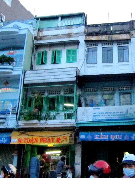

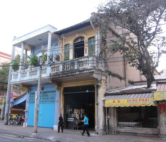


A collection of old houses in District 5, District 6, Binh Tan District ... Old Sai Gon Architecture (Part 1)
18 notes
·
View notes
Photo

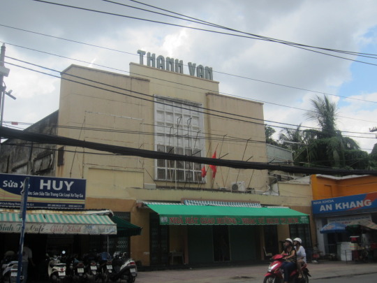
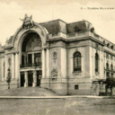
Van Thanh Theatre at 360 Cach Mang Thang Tam has been around at least prior to 1975. It has operated as both a traditional theatre and movie theatre in the past and currently serves as the practice area for the Ballet & Symphony Orchestra of Ho Chi Minh City, but it appears it is not open to the general public.
5 notes
·
View notes
Photo
I was strolling along Nam Ky Khoi Nghia Street today and happened to glance down at a manhole cover and spotted this. It was quite surprising to see this steel manhole cover from 1876 with the words Saigon Artillery Branch in French. It is located on the corner of Nam Ky Khoi Nghia and Nguyen Du Streets. A historic area of town for sure, but this is quite a mystery. Anyone out there have any ideas/theories about this?
1 note
·
View note