beyondlimitsonfoot
Beyond Limits on Foot
Find your adventure here
239 posts
Don't wanna be here? Send us removal request.
Last Seen Blogs

poutycake
૮⍝( ˚ᆺ˚ )⍝ა

steelboxmaker
Metal Box Machine

fuzzywizardmaker
Untitled

iptntake
なんか日記

kawaii-lolita-girl
Lolita Fashion Tutorials and Tips
Text
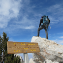
Kern River Trail: Kern County
Kern River Trail: Kern County
View On WordPress
#backpacking#california adventure#Hike#hiking#kern#kern river#la hikes#los angeles hiking#outdoor adveture#Outdoors#River#river trip
2 notes
·
View notes
Text
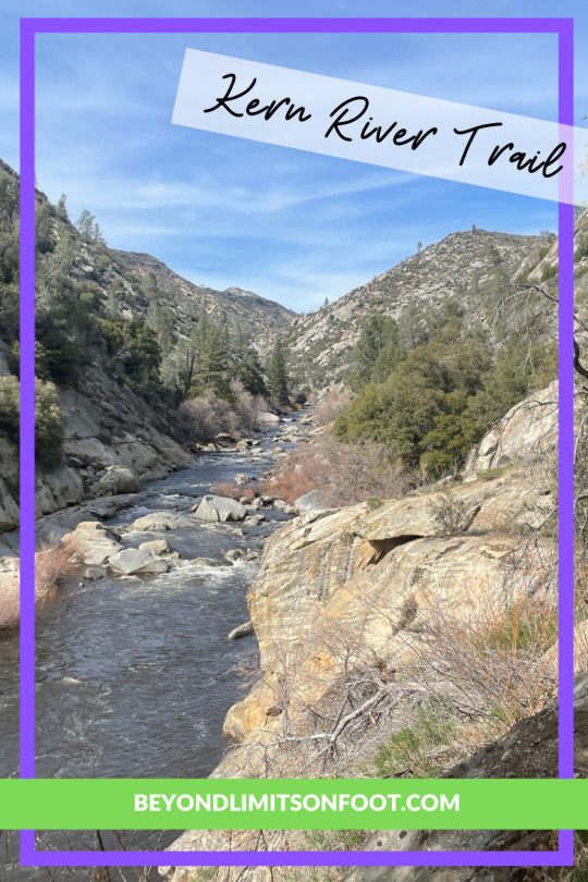
Misery Ridge Trail Loop: Smith Rock State Park
Misery Ridge Trail Loop: Smith Rock State Park
View On WordPress
#crooked river#hiking#misery ridge trail#oregon hiking#oregon trails#smith rock#Smith Rock State Park#Trail
0 notes
Text
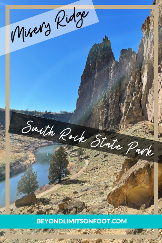
San Gorgonio via South Fork Trail - San Bernardino National Forest
San Gorgonio via South Fork Trail – San Bernardino National Forest
View On WordPress
#backpacking#big bear hikes#Hike#hiking#los anageles hikes#san gorgonio#SoCalHiker#southern california hikes#training
0 notes
Text
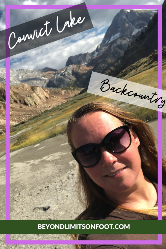
Convict Lake Backcountry - John Muir Wilderness
Convict Lake Backcountry – John Muir Wilderness
View On WordPress
0 notes
Text
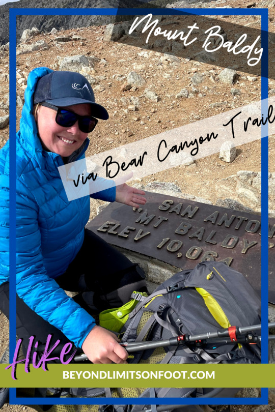
Mt. Baldy Loop via Bear Canyon Trail
Southern California hike: Training hike perfect for someone living about to embark on the John Muir Trail (which is what we were training for). 16 miles | 5.700 ft elevation gain.
View On WordPress
#adventure#backpacking#Hike#hiking#hiking blog#jmt training#la hikes#Mt. Baldy#Outdoors#san bernardino hiking#trails#training hike
0 notes
Text
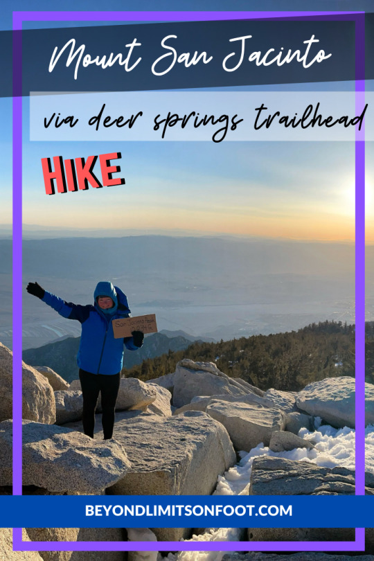
Mt. San Jacinto via Deer Springs Trail
Mt. San Jacinto is one of the tallest peaks in Southern California towering above 10,000 feet. Great training hike for the John Muir Trail that we did in June 2021. Despite the snow on the mountain there was still a lot people climbing the peak for the day.
View On WordPress
#adventure#backpacking#California#hiking#john muir trial training#la hike#la hikes#Outdoors#san jacinto#southern california hikes#trianing hike#Wilderness
0 notes
Text
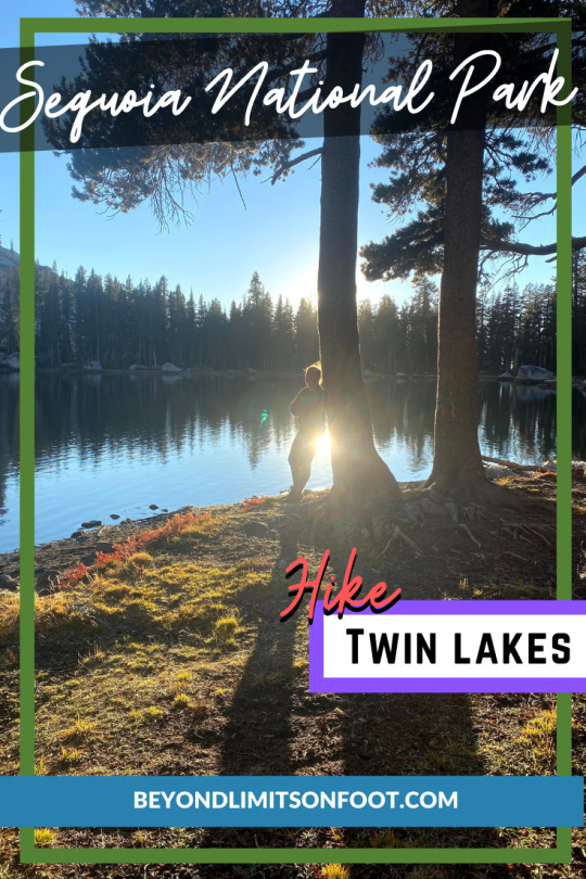
Twin Lakes: Sequoia National Park
Twin Lakes, a hidden couple of lakes in the vast Sequoia National Park. Sits at 9,400 ft, great fishing & other destinations to get to easily.
View On WordPress
#adventure#backpacking#explore#fishing#Hike#hiking#Lakes#Outdoors#Sequoia#sequoia national park#Trail#twin lakes
1 note
·
View note
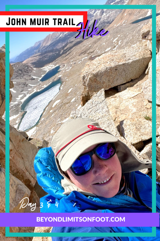
Text
John Muir Trail: Day 3 & 4
View On WordPress
#backpacking#bighorn plateau#forester pass#guitar lake#Hike#hiking#inyo national forest#john muir trail#Outdoors#tent#Trail#Wilderness
1 note
·
View note
Text
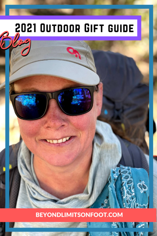
2021 Outdoor Gift Guide
2021 Outdoor Gift Guide - Spent a little time picking out my favorites as great gifts for anyone who is into the outdoors. Check them out.
can’t wait to get out there with some of these items?
2021 has been quite the year; I hiked the John Muir Trail, something I’ve wanted to do for over 10 years and was fortunate enough to make it work with my job, no fires, no forest closures. I noticed in the past couple years that many people have turned to the outdoors for fun and enjoyment, activity, something to do and/or even a little…
View On WordPress
0 notes
Text
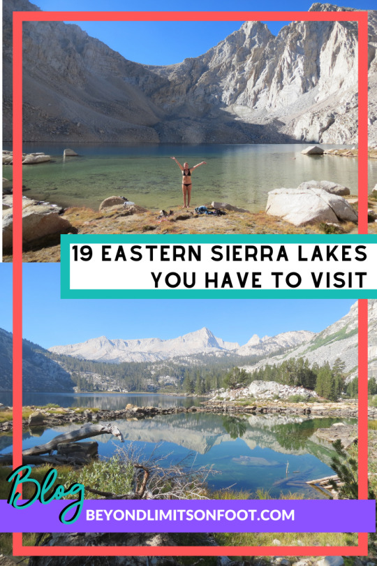
19 Eastern Sierra Lakes that You Have to Visit
View On WordPress
1 note
·
View note
Text
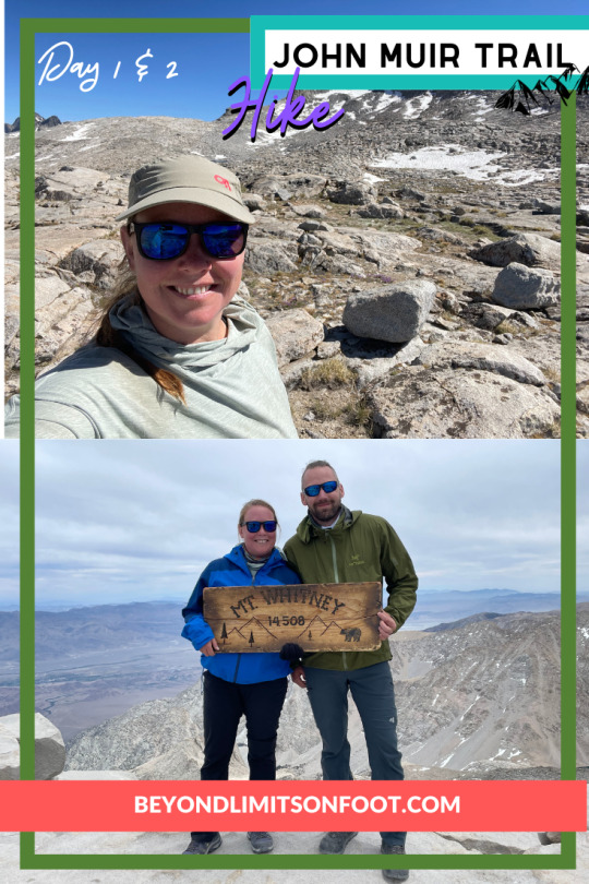
John Muir Trail: Day 1&2
John Muir Trail: Day 1&2
View On WordPress
2 notes
·
View notes
Text
Unfortunately this seems to be a very popular trail. Please make sure that you practice Leave No Trace; we found a lot of trash here and there. We found a couple campfires; it specifically says no campfires on this trail when you pick up your permits.
*Originally hiked on June 9, 2019 & June 2, 2018
Location Mileage Elevation Gain Type Inyo National Forest/John Muir Wilderness 11.4 miles 2,750 feet Out-and-back
— What to Expect in this Guide —
Background – Fun facts, trailhead info, things to know, map of hike.
Itinerary Options – Some ideas following 1-3 day options for you to choose from.
Weather – Always important to check the weather before you head out.
Permits – This section includes how to put in for a permit and where to pick up the permit. *Permit is required to hike in this area.
Directions – how to get to the trailhead.
Maps, Books and Gear Recommendations – A source for important maps that you should take on a hike, reading material before the hike and some recommendations on gear items that would be great for the hike.
Check Them Out – More fun reads by other authors that you can check out.
Hike Stats – Quick overview of the mileage and elevation for points of interest on the hike.
Description – Just in case you want to just hear my story and see some more My favorite part is the recollection of the hike and the awesome pictures that I can share with you guys. Be sure to check out my rambling and photographs in this section.
Before I get into the guide, I wrote a couple recipes down that we have taken on the trail. We actually did the To-Go Wraps for both 2018 & 2019 trips and made Tacos at 10,000 Feet. Check them out.
Also, if you are one of those people who love video blogs more than reading all the blabbering in the world you should check out my channel and some great footage from this spectacular hike.
— Twinted Inspiration —
One of the best things about getting outdoors is we get an inspiration to draw/design the places we have been to. My sister and I have a small side business in which we make our designs come to life. Our Moments page on Twinted website: temple crag show how the design comes to life. Check out then big pine collection.
Big Pine Lake Second Lake, pencil drawing by Michelle Halloran
@twintedinc
Digitized drawing of the above on a sweater available for purchase!
— Background —
Big Pine Creek North Fork trail is nestled in the California High Sierras west of Bishop and Big Pine. A fun fact about the trail is there is a cabin about 3.5 miles in that was once a summer home to a Hollywood Star. Lon Chaney was an famous American stage and film actor, director, screenwriting and make-up artist. He was well known for The Hunchback of Notre Dame and Phantom of the Opera. Chaney had a summer cabin built for himself made of stone and wood (1929). This cabin still stands and is a nice place to day hike to if in the area or pass by on a longer backpacking trip. Inyo National Forest Service has taken over ownership as a Ranger Cabin and visitors are not allowed inside.
— Trailhead Info —
Big Pine Creek North Fork
The trailhead to Big Pine Lakes is at the end of Glacier Lodge Road. Glacier Lodge burnt down in 1998, but they still have cabins for rent, a small store, showers and a free trout. A campground is available for overnight use for a fee. This is the last place you will see a vault toilet if you are off to the lakes.
Glacier Lodge Website
— Things to Know —
This is the know before you go section.
No campfires are allowed in the area
Food, scented items and waste must be stored in a bear canister
Burry human waste 100 feet away from water sources and 6-8 inches deep
Check snow report before entering in (2019 we had a huge snow year and we took our microspikes).
— Map of Hike —
Big Pine Area Trails Map on recreation.gov
— Itinerary Options —
One Day
Even if you do this as a day hike, take your essential gear for the day and in case of emergency.
Hike ~11.4 miles; ~2,750′ elevation gain out-and-back
Two Day
Day 1 – Hike ~6.5 miles; ~2750′ elevation gain from trailhead to Fourth Lake (make sure to stop at Second Lake and even Third) *option to go to 5th lake for an extra 0.6 mi
Day 2 – Hike ~10 miles; ~850′ elevation gain from Fourth Lake to Summit Lake and Black Lake to trailhead *option to go to 6th and 7th lakes for an extra 2.0 miles
Three Day
See all the lakes and take side trip to Palisade Glacier.
— Weather —
The weather both years was absolutely amazing, but the week after I heard that there were hurricane like winds up there in the same area. It did get very cold this year (2019). The weather can change at any time in the mountains, be sure to prepare and pack the right things as needed.
Glacier Lodge (Near trailhead) – Elevation 7,313 feet
Third Lake – Elevation 10,892 feet
— Permits —
— Backcountry Permit —
Day Hikes: You are not required to have a wilderness permit for a day hike. Be sure to leave your itinerary with your family in case anything happens.
Backcountry Permits are required to hike overnight in the John Muir Wilderness Area. To obtain a permit you can obtain it in person at any of the Inyo National Forest Visitor Centers or to be sure you get a permit, reserve up to 6 months in advance on the Recreation.gov website. Just like most trails in there is an overnight quote, so planning ahead is advised.
*Note: You will not be refunded the $6 reservation fee at any point after completing the purchase. You can get refunded for the permit if you cancel the reservation up to 22 days in advance.
— Directions —
Big Pine Creek Trailhead
Address: 4024 Glacier Lodge Rd, Bishop, CA 93514
From Big Pine, turn west on W Crocker Ave. It will turn into Glacier Lodge Rd. in about .5 miles. Continue on Glacier Lodge Rd. for about 10 miles. There is day parking at the trailhead and the trout pond, no overnight for vehicles here. You can park closer to the trailhead near Glacier Lodge by talking to the owners who will tell you where to park (there is a fee) or drive back out to the Hiker Parking area. The difference in mileage isn’t much though.
— Maps, Books & Gear Recommendations —
— Maps —
1. Palisades Trail Map (Tom Harrison Maps) – My favorite type of maps are the Tom Harrison Maps. This is the perfect one for this hike; it is also available at the Visitor Center if you forget to buy one ahead of time.
2. Caltopo map of Big Pine Creek North Fork to Third Lake – This is a map I created on CalTopo of the exact route that we took. I also have a photo of it attached above.
3. Sierra South: Backcountry Trips in Californias Sierra Nevada– A book about other hikes in the Southern Sierras. I find most of my trips in this book and the tom harrison maps that I’ve bought throughout the years.
— Some Gear Recommendations —
1. Patagonia Women’s Ultralight Down Jacket – I don’t have this jacket yet, but I have heard so many good things about it. It may just be in my next shopping spree.
2. Sea To Summit Aeros Pillow Premium– This is by far the best sleeping gear I have ever bought. I usually wrap my down jacket and scarf around it to make it even more comfortable. I’ve learned throughout the years to not blow it up all the way; this will allow the pillow to conform to your head better.
3. Sea to Summit X-Pan, 8″, Orange – If you want to make those tacos above 10,000 feet like in my blog: Tacos at 10,000 Feet, then this would be the best kitchen supply you can use for it. We actually used this on this trip, that’s why it’s on my gear recommendations list. Very easy to clean and cook in it.
Check out What’s in My Backpack? and Trail Food: Grub Ideas for the Trail for more of the items I take on a hike.
— Check Them Out —
Before I go on hikes, I always like to check out other write-ups to see if the person who went has any good ideas and just to see how their trip went. Here were some good reads you can check out.
Big Pine Lakes via the North Fork of Big Pine Creek by Modern Hiker
Hiking To Big Pine Lakes via The North Fork Trail by Trail to Peak
Big Pine Creek North Fork Trail by Explore More Nature
North Fork Big Pine Creek (Summer) – Inyo NF, CA by backcountrycow.com
Hiking the North Fork of Big Pine by CaliTrails
— Hike Stats —
Point of Interest Mileage Elevation Big Pine Creek Trailhead 0 miles 7,814 feet Big Pine Wilderness Camp 2.7 miles 9,196 feet Lon Chaney Cabin 3.5 miles 9,220 feet First Lake 4.5 miles 9,980 feet Second Lake 5.1 miles 10,138 feet Third Lake 5.5 miles 10,283 feet Fourth Lake 6.5 miles 10,750 feet Fifth Lake 6.8 miles 10,683 feet Sixth Lake 8 miles 10,983 feet Seventh Lake 8.5 miles 11,083 feet
— Description —
I’ve been itching so long to go to Big Pine Lakes and the way I had it planned it didn’t really end up working out that way, but I still had a very good time. We had a friend in town the night before visiting from Canada, which in turn as the trip leader, decided to let everyone sleep in a little longer. Instead of waking up at 3:30am like I planned, we woke up at 5:00am and ended up leaving the house around 6:00am. Not too bad considering to get the permits we were about a 3 and half hour drive away.
Getting there
We arrived at the Eastern Sierra Agency Visitor Center around 10:00am and luckily there were only a couple people in front of us in line. I intended to arrive at the ranger station when it opened, so we could get on the trail much earlier. The visitor center opens at 8:00am and usually there is a line on a Saturday morning; this is where you would pick up your Mt. Whitney permits if you intend to climb that beast. The ranger mentioned that I was lucky to get a permit, because this trail is very popular. I wasn’t too excited to see too many people, but usually you can find your own area, it’s so vast out there.
From Lone Pine it took us another hour to get the Big Pine Lakes trailhead; we went straight to the Glacier Lodge Store and spoke to one of the owners about parking there. As mentioned above, there is a $5 fee for parking at Glacier Lodge. If you go back down Glacier Lodge Rd. there is a hikers parking area that is free for parking. We opted to park at Glacier Lodge. Do not park at the trailhead if you are planning on backpacking overnight.
Starting up the trail
We started up the trail at 11:00am approximately, a much later start than I am used to. We still had a full day to get up as far as we felt like going. The weather was quite pleasant. We got to the Second Lake around 3:00pm and it was full with people. We decided to take a break and head on towards Third Lake which was not much farther.
Third Lake had some people too, but it felt like we were alone and we found a very nice camp spot. After setting up our tents, we sat by the lake a little and fished. I had no bites at all and decided after a couple hours to go make dinner. We were going to have something delicious: TACOS. I have the recipe if any of you would like to take a look: Tacos at 10,000 Feet.
Heading back out
Didn’t take us very long to get back to the cars, but we did take our time in the morning and made some coffee with hot chocolate.
Note to self: Wake up earlier to be able to go further in or drive up on Friday night and stay close to Lone Pine or Bishop where you will pick up your permits.
Big Pine Creek North Fork trail - popular destination. If solitude is what you seek you won't get it; if perfect scenery, this is the place. Unfortunately this seems to be a very popular trail. Please make sure that you practice Leave No Trace…
#adventure#backpacking#big pine lakes#forest#Hike#hiking#John Muir Wilderness#Lakes#Mountains#National Forest#outdoorlife#Outdoors#Trail#Wilderness
0 notes
Text
Robinson Lake is one of the closer lakes by hiking in the Eastern Sierras, but little did we know that it was one of the steeper trails we’ve ever done. The elevation gain is 1,350 feet in 1.4 miles. To say the least that is a very steep grade for a lot of trails; I would say this is a great training hike if you want to get a lot of elevation gain within a short amount of time.
Location Mileage Elevation Gain Type Inyo National Forest 3.27 mi 1,325 feet Out-and-back
What’s in this Guide?
Feel free to scroll down to any of the sections below.
Map of Hike
Background of the area
Trail Information including trailhead location, elevation of trailhead and lake, permit information, weather and more information on the trail.
Directions
Gear Recommendations
Description of Hike
Map of Hike
Background
Onion Valley sits at 8,900 feet nestled 13 miles outside of a town called Independence off the US 395. There are several campgrounds on the way up to Onion Valley, where Onion Valley Campground is located as well as a couple trailheads including Kearsarge Pass, Golden Trout Lake and Robinson Lake trails. These trails are great for both day hikers and backpackers as a destination to lakes is often the enjoyment of these overnight and day trips.
On the way up to Kearsarge Pass, a trail once used as an Indian trading route for centuries, offers 4 lakes that one may choose to stay the night at or day hike to. It is also your gateway to Kings Canyon National Park, joining up with the JMT (John Muir Trail) and PCT (Pacific Crest Trail) – two famous long distance trails. The Golden Trout Lakes begins on the same route to Kearsarge Pass, but veers right towards Kearsarge Peak. The trail is steep and rises 2,200 feet over 2.2 miles to Golden Trout Lakes. Both of these trails can lead to epic summits surrounding the area.
Trail Info
Trailhead – located inside the Onion Valley Campground. It is not the same trail as getting to Kearsarge Pass.
Elevation – Trailhead (9,200 feet), Robinson Lake (10,500 feet)
Permits – Required for overnight trips, obtain on Recreation.gov website or at any Inyo National Forest ranger station/visitor center.
Weather – Onion Valley Campground ~9,000 feet; Robinson Lake ~11,000 feet
Forest Service Information on Robinson Lake Trail – more information about the trail
Directions
From Independence, take Market St west. Market St turns into Onion Valley Rd and continue on road for 12.8 miles till you reach the Onion Valley Campground. Parking for hikers is located right before the campground near the Kearsarge Pass trailhead. Walk through the campground and look for trailhead signs for Robinson Lake.
Gear Recommendations
amzn_assoc_placement = "adunit0"; amzn_assoc_search_bar = "true"; amzn_assoc_tracking_id = "beyondlimit03-20"; amzn_assoc_ad_mode = "manual"; amzn_assoc_ad_type = "smart"; amzn_assoc_marketplace = "amazon"; amzn_assoc_region = "US"; amzn_assoc_title = "My Amazon Picks"; amzn_assoc_linkid = "c640afc41149fe28055d0595012fdc48"; amzn_assoc_asins = "B07WL6QHWH,B01C51L06O,B019TQPL4A,B0753NBMJ5,B0792J6FG8,B017JFWZ4W,B008J5FA8K,B01MY03CZP";
The Hike
*originally hiked: 11/9/19
Reaching Onion Valley Campground around 12:30 pm, we hit the hike just after deciding to make the trek up since it was a short one. The road up to Onion Valley is pretty cool considering we were able to see the abundance of fall colors. When we reached the parking area, there were only a couple other cars. We packed up our day packs and headed through the campground to the trailhead.
The trailhead is very easy to find, but not easy to hike. I remember being super sore already and it made it rough to climb up to Robinson Lake. The beginning of the trail is just past the campsites and right away climbs switchback after switchback. The second part of the hike has very short switchbacks and feels like it just goes straight up.
quick trip
The sun would be hiding behind the mountains soon, so we scurried up as fast as we could to get a look at the lake with the sun gleaming on it. Spent about 45 min around the lake fishing and relaxing. There were only two fish, being that it was very late in the season and considering the lake was covered in ice.
I was worried on the way down because I didn’t bring hiking poles (mainly because I forget them at home, didn’t think we were going to do any hiking). Luckily the hike was short enough that it didn’t make much of a difference for having them or not, but I would have really liked to have them on the uphill.
Follow @beyondlimitsonfoot on Instagram
[ap_instagram_slider]
Robinson Lake via Onion Valley: Inyo National Forest - Robinson Lake, short, steep hike outside of Independence, CA (Eastern Sierras). 1,350 feet vertical, 1.5 miles. Lake surrounded by towering mountains. Robinson Lake is one of the closer lakes by hiking in the Eastern Sierras, but little did we know that it was one of the steeper trails we've ever done.
0 notes
Text
15 Items That Always Go In My Hiking Backpack
15 Items That Always Go In My Hiking Backpack
Thursday evenings are mostly spent finishing packing my backpack for an adventure for the weekend. I usually begin packing earlier in the week, some of my stuff is even packed from another trip; but this helps me decide if I need to make a trip to the store if I am missing anything. Since I work full time, most of these hiking trips are day trips or a quick overnight trip; this in turn means…
View On WordPress
0 notes
Text
Most people who climb Mt. Baden Powell will start from the Vincent Gap style, we decided to go a different route and allow summits to a couple more peaks in the area. We didn’t decide to do Baden Powell until we got to Mt. Burnham, but that’s the beauty of having a map with you, you can decide to turn around or keep going. Always check before you get out there.
Location Mileage Elevation Gain Type Angeles National Forest 9.5 miles 2,650 feet Out-and-back
— What to Expect in this Guide —
Map of Hike – Map of what our hike looked like.
Directions – Make sure the road is opened, different times of year they close the road either due to road work or winter weather.
Weather – Weather changes often, make sure you check before you go.
Permits and Passes – No overnight wilderness permit is required, but an Angeles National Forest Adventure Pass is. Read more on how to get one below.
Hike Stats – Quick overview of the mileage and elevation for points of interest on the hike.
Maps, Books and Gear Recommendations – I like to put together some important items or even just some gear ideas for your adventure, check them out in this section.
Description – This is my favorite part because I can share my adventure and photos with you.
amzn_assoc_placement = "adunit0"; amzn_assoc_tracking_id = "beyondlimit03-20"; amzn_assoc_ad_mode = "manual"; amzn_assoc_ad_type = "smart"; amzn_assoc_marketplace = "amazon"; amzn_assoc_region = "US"; amzn_assoc_linkid = "2aadd0a9abf81618417f804a216ef9f1"; amzn_assoc_design = "in_content"; amzn_assoc_asins = "B01HBOT4YK,B06WVK7LZS";
— Background —
The 3 of these peaks are around 9,000 feet elevation, which is perfect training before attempting higher elevation hikes. Here’s some history on the naming’s of each of the peaks.
The first of the 3 peaks is named Throop Peak (9,142 feet), named after Amos G. Throop founder of Throop University in 1891, also known as Caltech now.
The second peak is Mount Burnham (9,001 feet), originally named West Twin or North Baldy Mountain, it was renamed in 1951 after Frederick Russell Burnham a military scout who taught woodcraft to Robert Baden-Powell who was a big inspiration for the founding of Boy Scouts.
The 3rd peak we hit was originally named East Twin or North Baldy and was renamed to Mount Baden-Powell (9,407 feet) in 1931 after the founder of the Scouting Movement, Robert Baden-Powell.
— Map of Hike —
— Directions —
Dawson Saddle Trailhead
To get to the trail from Wrightwood, take Hwy 2 off of CA-138 W. Once you get on Hwy 2, take it all the way to Dawson Saddle. There are two trailheads that end up leading to the same place. Something to note is that there is no sign posted to mark the trail, but it is easy to see both trails off the highway.
— Weather —
The weather can change at any time in the mountains, due to this fact be sure to prepare. This area is known to get very hot in the summertime; hike early to minimize impact of any heat illness. In contrast this area can also get very cold and windy with even snow on it, prepare for anything!
Mt. Baldy – Elevation 10,066 feet
— Permits and Passes —
— Wilderness Permit —You are not required to have a wilderness permit for a day hike neither an overnight hike.
— National Forest Adventure Pass —The trailhead lies within the Angeles National Forest in which you are required to obtain an Adventure pass. Find the closest Forest Service location or go to a major sporting goods store. The fees are either daily ($5 per day) or annual ($30). If you’d like to know more about the pass, read on the USDA Forest Service Recreation Passes & Permits Website.
— Hike Stats —
Point of Interest Mileage Elevation Trailhead: Dawson Saddle Trail 0 miles 7,901 feet PCT junction 1.8 miles 8,850 feet Throop Peak 2.0 miles 9,138 feet Mt. Burnham 4.1 miles 8,997 feet Mt. Baden-Powell 4.75 miles 9,399 feet
— Maps, Books & Gear Recommendations —
amzn_assoc_placement = "adunit0"; amzn_assoc_search_bar = "true"; amzn_assoc_tracking_id = "beyondlimit03-20"; amzn_assoc_ad_mode = "manual"; amzn_assoc_ad_type = "smart"; amzn_assoc_marketplace = "amazon"; amzn_assoc_region = "US"; amzn_assoc_title = "My Amazon Picks"; amzn_assoc_linkid = "1e6bb772c0f839cfadd3435853cd5b0e"; amzn_assoc_asins = "B01C51L06O,B07V9JJZWB,B017JFWZ4W,B00B97A4FO";
— Maps —
Tom Harrison Angeles High Country Trail Map – My favorite type of maps are the Tom Harrison Maps. This is the perfect one for this hike.
HIKE Southern California: A Day Hiker’s Guide – My mom got me this tiny little book. I’ve took it out a few times before I head out into the local mountains and it has given me some good ideas for hikes.
— Some Gear Recommendations —
Black Diamond Alpine Carbon Cork Trekking Poles – I definitely recommend trekking poles for this hike it will save your knees.
Garmin Fenix 5s Plus – I use this every hike now. It doesn’t have a satellite communicator, but the maps and it’s functionalities are perfect for hiking.
Osprey Hydraulics Reservoir – I recommend taking a lot of water and this reservoir fits 3 liters. Check it out.
PROBAR Bolt Energy Chews – Feel like you��re getting tired, take some of these for some quick energy; they are my favorite energy chews out there.
Check out some of the other items I have in my backpack on hiking and backpacking trips on my What’s in My Backpack Page. I also have some trail food ideas – check those out on Trail Food: Grub Ideas for the Trail
— Description —
Before I get into the trip, if you’d like to take a gander at the YouTube video I made of the hike check it out below or on my YouTube.
I have wanted to this hike so many times, but every time we went we had to figure out another hike to do because the road was closed. Always check the road closures before heading up; this time we were lucky enough for an open road to Vincent Saddle. We reached the small parking area at Vincent Saddle around 8:00am and there was only one other car parked there. There are two trails that connect shortly after starting the hike.
Before we set out of the hike, the plan was to summit Throop Peak and Mt. Burnham then turn around. I didn’t realize until later that it would make for a short hike. On our way up to Throop Peak we were covered by the trees and the beautiful sun’s rays gleamed through the trees as we climbed to the Pacific Crest Trail (PCT) junction. After almost 2 miles we hit the junction and emerged from the shade.
summiting Throop Peak and Mt. Burnham
To the right there is a small use trail that goes up to Throop Peak another .2 miles. We topped Throop and decided to take a short break and have our hard boiled eggs. One of my favorite breakfasts when I am hiking is boiled eggs on the first day of a backpacking trip or a day hike. After the short break we scattered down back to the PCT and Dawson Saddle Trail junction. We continued northeast toward Mt. Burnham; on the way to Burnham there is a decrease in elevation to about 8,000 feet.
Mt. Burnham was only a mile away from Throop Peak, proved to be a great training summit, but not enough for us to turn around. Atop Burnham we made the decision to summit one more peak. Mt. Baden-Powell was in the distance which would make for approximately a 9.5 mile hike. There were two options, summit Mt. Baden-Powell and come back the way we hiked or drop down to Vincent Gap and try to hitchhike back to car. We figured we’d weigh in our options after summiting Baden-Powell.
summiting Mt. Baden-Powell
I’ve been up to Baden-Powell two times already, but always from Vincent Gap. Honestly this was a much easier hill to summit as we were already at higher elevation than the Vincent Gap way. From Burnham to Baden-Powell there is 360 degree views of the mountains and valleys around; much of the trail sits on the ridge between the two peaks. If I remember correctly we had only seen 3 people before leaving Mt. Burnham and when we reached the summit of Mt. Baden-Powell there were at least 50 people.
We ate our To-Go Wraps here and decided to head back to the cars. On the way back we went the same way except stayed on the PCT (Pacific Crest Trail) to bypass the summiting of the peaks. Although, I must say it felt much longer that summiting again; but was cool so see a new part of the mountain.
We reached the car just before 1:00pm; this is one of the reasons I like going earlier as now we have the rest of the day to clean up at relax at home. The hike was challenging and my knee didn’t act up, guess all that gym work has been finally paying off.
Thanks for listening, hope you guys enjoyed the write-up and let me know if you have any questions about hiking or backpacking this trail.
Happy Adventures,
Annette – Beyond Limits on Foot
— Follow @beyondlimitsonfoot on Instagram —
[ap_instagram_slider]
3 peaks to summit in the local Southern California Angeles National Forest. All spanning above 8,900 feet, this will sure kick your butt! Want to hike it? Most people who climb Mt. Baden Powell will start from the Vincent Gap style, we decided to go a different route and allow summits to a couple more peaks in the area.
#Angeles National Forest#day hike#Hike#los angeles hike#mt. baden-powell#mt. burnham#National Forest#throop peak#view of los angeles#Wilderness
0 notes
Photo
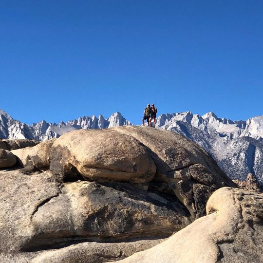
I spy Mt. Whitney, tallest peak in the lower 48 of the US. #mtwhitney ⛰ #beyondlimitsonfoot ⛰ #adventure #alabamahills #lonepine #395north #viewsfordays #californiaadventure #weekendgetaway #wildernessculture #womenwhoexplore #exploremore #getoutside #adventuretime #mountains #takemeoutside #optoutside (at Alabama Hills, California) https://www.instagram.com/p/B4zr74JhmwD/?igshid=re5v1xqo70k7
#mtwhitney#beyondlimitsonfoot#adventure#alabamahills#lonepine#395north#viewsfordays#californiaadventure#weekendgetaway#wildernessculture#womenwhoexplore#exploremore#getoutside#adventuretime#mountains#takemeoutside#optoutside
0 notes
Photo
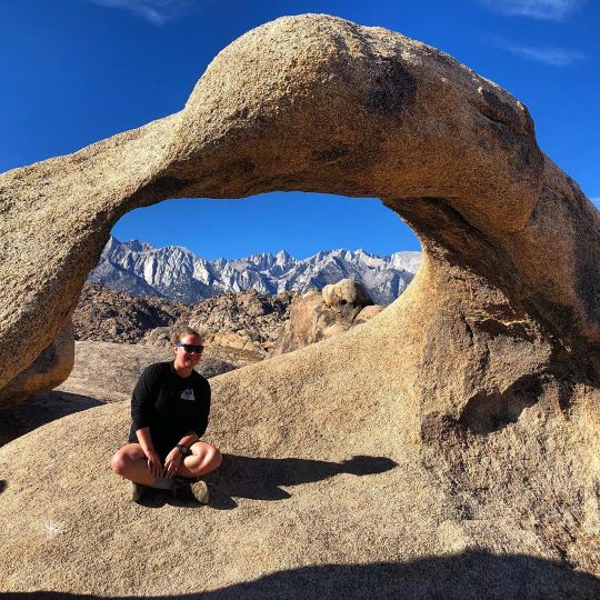
It’s funny how this is the first time I ever saw in person Mobius Arch. We have been driving past it for years! And what a view behind me of My. Whitney and the surrounding Eastern Sierras! ⛰ #beyondlimitsonfoot ⛰ #alabamahills #mtwhitney #eastersierras #mobiusarch #395north #californiaadventure #weekendgetaway #getoutside #adventuretime #womenwhoadventure #womenwhohike #hikeit #getoutside #outdoors #outdooradventure #wildernessculture #exploremore (at Mobius Arch) https://www.instagram.com/p/B4v_O9hhrcv/?igshid=pfbsbsee5sbu
#beyondlimitsonfoot#alabamahills#mtwhitney#eastersierras#mobiusarch#395north#californiaadventure#weekendgetaway#getoutside#adventuretime#womenwhoadventure#womenwhohike#hikeit#outdoors#outdooradventure#wildernessculture#exploremore
0 notes