
Last Seen Blogs


Text
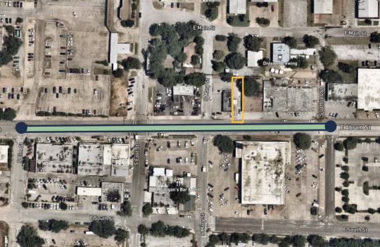
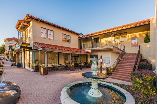
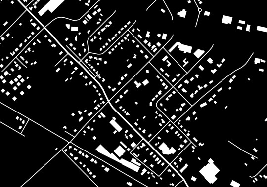
DOWNTOWN ARLINGTON//ABRAM ST
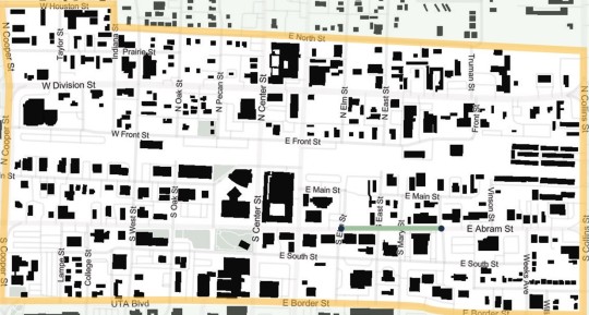
SITE - DOWNTOWN ARLINGTON
Our intent is to better access to food and heighten interest in the location by increasing walkability, implementing a food market and aesthetically pleasing art.


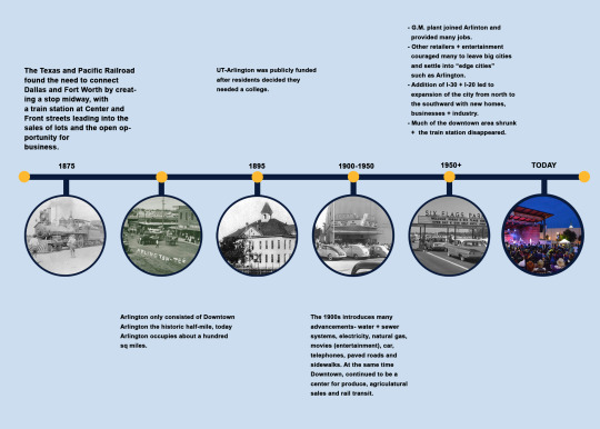
History
Demographics

Annual % Change 2010-2016
Arlington 0.8%
Downtown 0.7%

Annual % Change 2010-2016
Arlington 0.2%
Downtown 0.9%
Housing
In Arlington the market for housing is mainly concentrated in the single family detached home and multifamily apartments. There is very little variety between these two ends of the housing spectrum.
In the past years Downtown Arlington has had a small population and a number of housing corresponding to it.
Because the population in the Downtown area is changing, there is a need to change the number of housing as well. Projects like the construction of 101 Center Street, 404 Border and Park Place adds 676 new units in Downtown.
In Downtown the biggest demand for housing has always been for UT Arlington students and is also still increasing .

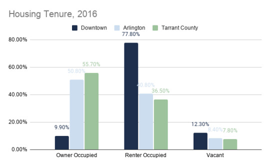
Demographics of a downtown tend to always vary in comparison to citywide averages since there is always a difference in the housing types available and in the characteristics of people that choose to live in downtown.
Arlington city and Tarrant County on average are very similar in the percentage of renters and owners.
Downtown has a much higher renters average due to the proximity of UTA to downtown.


Downtown is heavily influenced by student population and younger adults (median age 24.5) and shows that its demographics are typically weighted towards small households (no children) .
The median household income for downtown is only half of the citywide median.

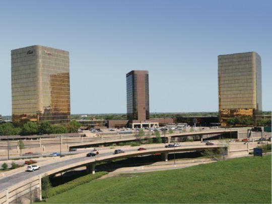
Transportation
Bike Lanes-Downtown

Via
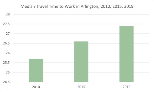
Travel Methods in Arlington
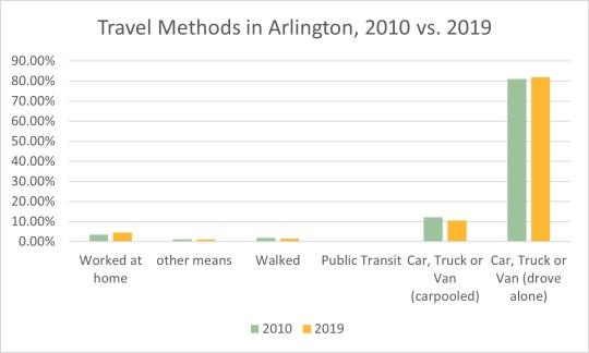
Travel + Work

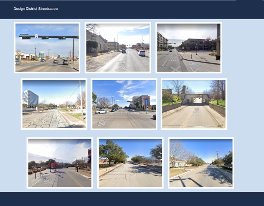
Design district streetscape
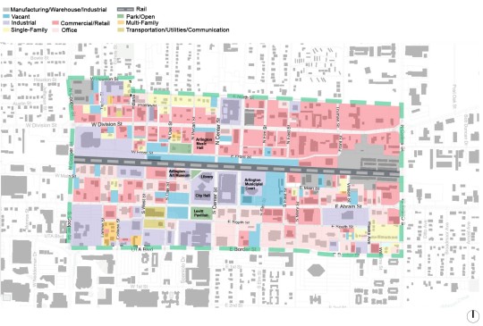
Land Use
Parks

Culture - Downtown Arlington

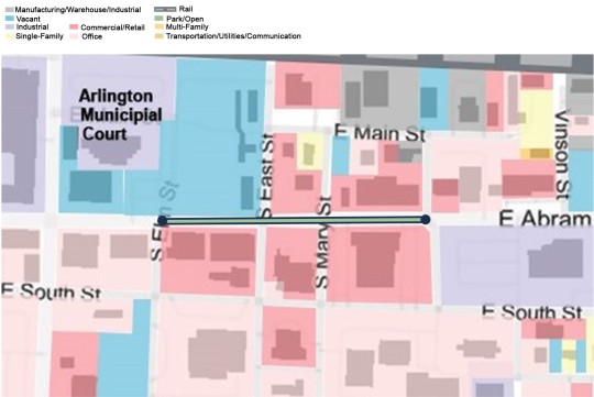
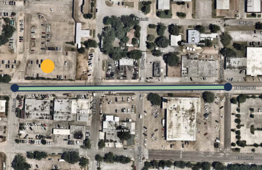
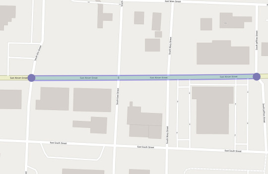
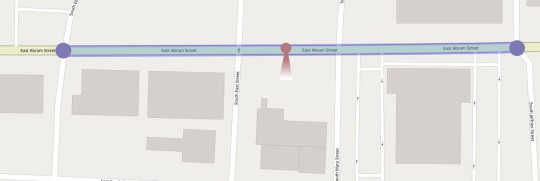
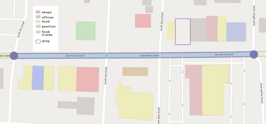
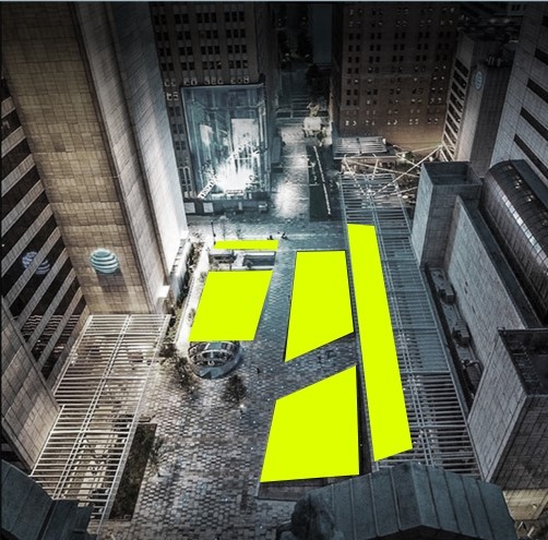
Proposal + Site: Abram St -Between Elm + Jeffries St

Land Use - Abram St
City of Arlington - Online Survey
The city of Arlington in 2018 (March 26-30) conducted an online survey, as part of their Downtown renovation master plan and public engagement process. The survey allowed the city to collect feedback from residents about eh existing Downtown conditions and visions for the future.
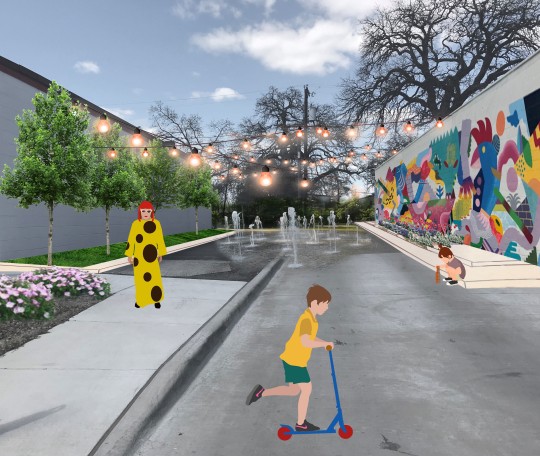
Public Interactive Space- Art, seating space, water + Trees

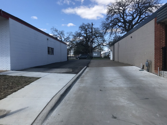
Before:
After:
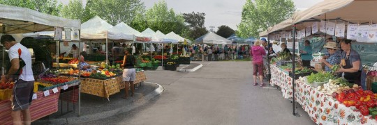
Farmers Market


Before:

After:
Street
Before

After

0 notes
Text
Arlington + UTA a Food Desert
Arlington falls into the definition of a food desert as an urban neighborhood without ready access to fresh and affordable food.
- Heavy on convenience stores, mostly providing processed food high on calories and low in nutrients
- Majority of the population that live in low-income areas have lesser access to healthy affordable food/ grocery stores.
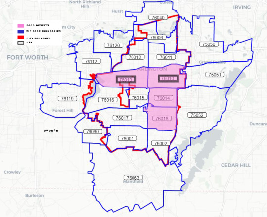
Specific Food Desert Areas in Arlington

UTA Campus

I-20 to Pioneer Parkway/Cooper to 360
Scarce amount of markets within these areas
Not all markets are easily accessible by foot or bike due to car-congested location
Current UTA Resources
Food Pantry- by the TRI-C, provide various non-perishable to students or faculty
Community garden - 78 plots in half acre garden available for families and community members for only $35 annual cost + agreeing to donate at least half of produce to Mission Arlington (program’s food bank)
Shuttle services- provides transportation on Saturdays for $2 to the mall, target and Aldi .
Possible ways of alleviating food insecurity:
The issue of food insecurity is very complicated with many components that are tied to the bigger issue of food insecurity.
There is also the question of should we bring the food to the people or should we bring the people to the food.
A good start in trying to alleviate food insecurity is to add more of the following in our communities.
Community Gardens:
Provide locally grown fresh food + can have connections to local markets and/or food banks.
Helps mainly at the scale of neighborhoods,
at a walkable distance for no need of a car.
Ex) Shiloh Field - Denton, Texas
Largest community garden in America , 14.5 acre
Delivers food to many organizations, Salvation Army + Denton County Food Bank
Families can also adopt individual plots for themselves at no cost.
They provide land, water and training .
Rely on donations + volunteers to help harvest .

Shiloh Garden - Denton TX
Food Banks and Food Pantries
Food Banks:
Play a big role in providing alleviating food insecurity by distributing donated and purchased groceries directly to food insecure families.
Usually rely on donors and volunteers to collect and distribute food.

Food Pantries:
Functions at a a smaller scale than Food banks, usually functioning as the ones reaching out to the community directly within a specified area and are self-governed.
Transportation is a systematic - long-range component that also plays a role in alleviating food insecurity around UTA + Arlington.
Different modes of public transit
Side walks help with walkability and best if food source is within 5 miles
Farmers Markets
Sell local/organic food regularly at designated public place (park of parking lot).

Boulder County Farmers Market | Colorado
0 notes
Text
New Urbanism and/or Landscape Urbanism
By Renaleigh Aquino & Maylin Juarez
New urbanism and landscape urbanism have both overlapping and different points, both important for the success of urban development.
Important Overlapping Points -
- want to lay out a great foundation for development
- concerned with urban sprawl
New Urbanism
New Urbanism focuses on human-scaled urban design: Walkable blocks and streets, housing and shopping in close proximity, and accessible public spaces.
New Urbanist streets are designed for people—rather than just cars—and accommodate multimodal transportation including walking, bicycling, transit use, and driving.
Believe in providing plazas, squares, sidewalks, cafes, and porches to host daily interaction and public life.
Reclaiming underutilized and neglected places is a special focus of New Urban design and building.
example: New Urbanism has transformed deteriorating public housing into livable mixed-income neighborhoods. Commercial strips with single-use development and excessive asphalt are transformed into lively main streets or boulevards through new urban design.
Landscape Urbanism
Proposes a new perspective when planning for development - placing the preservation of natural habitats first.
Landscape Urbanism focuses on the concept of finding a balance between natural and engineered systems, human and non-human habitats, the green of the landscape and the grey of the city.
Spatial constructions in urban environments should blend with the structure of the city instead of just being attached or isolated.
Example: Klyde Warren Park

A green park that sits on a freeway wanting to correct some of the negative impacts that highway systems bring, such as bisecting neighborhoods and pressuring American downtowns to rush into the development of car infrastructure. The park does this by connecting downtown and the arts district, providing different programs - restaurants, playground, dog park etc..
Compare and contrast
Travel
Landscape Urbanism
Maximizes the benefits of land; less dense area.
Excellent car travel, leading to more traffic jams and air pollution.
New Urbanism
Provides alternatives such as trains, buses, and cycling.
Focuses on the minimization of travel time by advocating Mixed Use; thus decreasing travel distances
Work
Landscape Urbanism
Separation of functions
Work mostly takes place in a different area
New Urbanism
Mixed Use promotes working in the same area
Leisure
Landscape Urbanism
Large potential for extensive recreation (walking, cycling)
New Urbanism
Large potential for intensive recreation (Skating, museums, Jogging, Surfing, Cultural Activities)
Shopping
Landscape Urbanism
Mostly accessible by car
Big shopping centers and malls
New Urbanism
Walking distances, small shops, alleys
Gardening
Landscape Urbanism
High potential
Spacious gardens
Possibility for food self-sufficiency
New Urbanism
Low potential
Only small roof gardens and little chances for food production
Social Contacts
Landscape Urbanism
Low daily interaction between inhabitants due to distances
A more rural life
New Urbanism
Vibrant city life; more frequent daily social interaction
Rushed city life can flatten social interactions
Both wanting to promote a great urban development foundation, we believe that both new urbanism and landscape urbanism have successful and weaker points of view, and between ideas it shouldn't be so divisive. A successful urban development plan is perhaps one that studies and takes the most successful points of both parties (specific to the project) and make the most out of it .
0 notes
Text
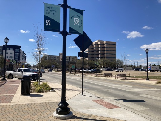
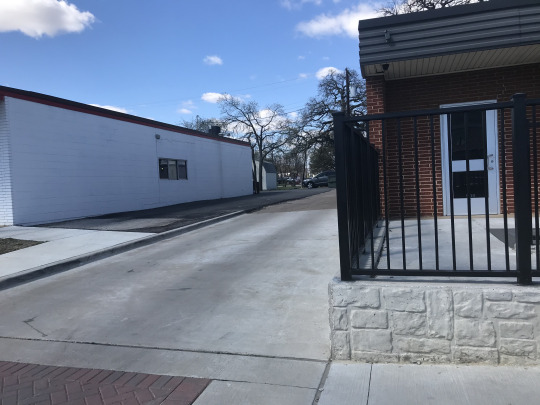
ABRAM ST - Between Elm + Jeffries St
By Renaleigh Aquino & Maylin Juarez
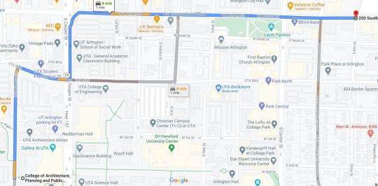
4 min from CAPPA by car
3 blocks

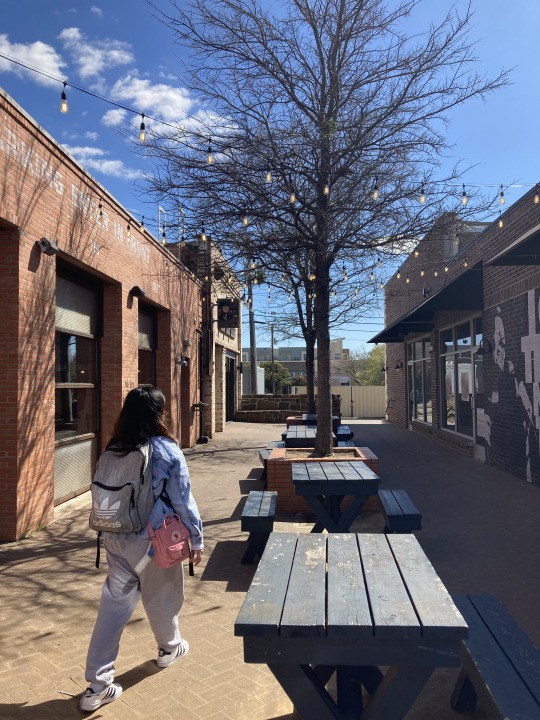
Most Successful Space:

Outdoor space
sitting,
natural shade
different food options
bike rail
light - night
Weaknesses between Elem + Jeffries st :
Parking- “Back in ”angle parking

Used wrong by many drivers , caused traffic to stop .
Walkability
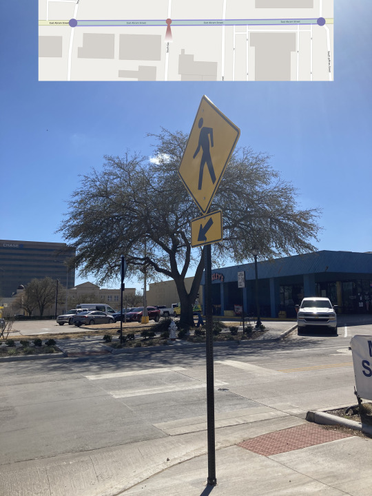
More car than pedestrian friendly.
Renaleigh and I were afraid of getting ran over so we waited a long time to be able to cross.
Seating
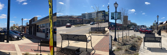
used poorly- not taking advantage of the opportunity to creating a reason why people would want to sit there.
No shade
Poor placement
Bikes
Although bikes are encouraged with the placement of bike rail, the lack of bike lanes makes bike riders ride on the sidewalks that people are always moving as they buy food.
Proposal

Pavilion- performances, picnics etc..
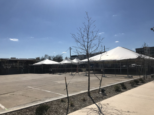

Food trucks + outdoor sitting would make a better use of this parking space .

Art - Murals , Food ,Water sitting and bios wales
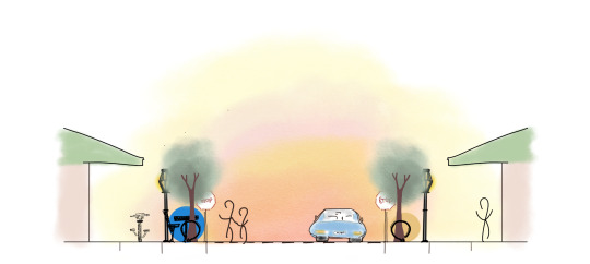
bike lanes + racks for a more bike friendly st.
seating with shading and more programming, more trees and safer crosswalks .
0 notes
Text
Lynch’s Urban Forms in DFW - Good & Bad
By Renaleigh Aquino & Maylin Juarez
PATHS
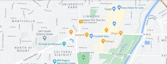
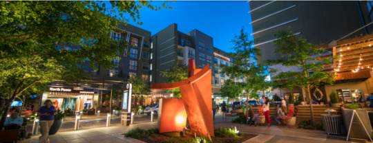
Good - Crockett Row at West 7th
In the heart of cultural district in Fort Worth
Vibrant- murals + interactive art
Many dining options
Shops
Spas
Entertainment- movie theater + karaoke
fitness- LA fitness
and is very walkable, close to trails and includes on-site fw Bcycle locations.

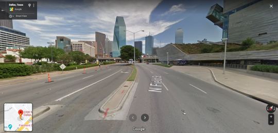
Bad - 2200 Block of N. Field St., Dallas
Because of the way that the museum is oriented, the side of Field st only faces concrete walls and a driveway, missing the opportunity to enliven the street and make it more pedestrian friendly.


Edges
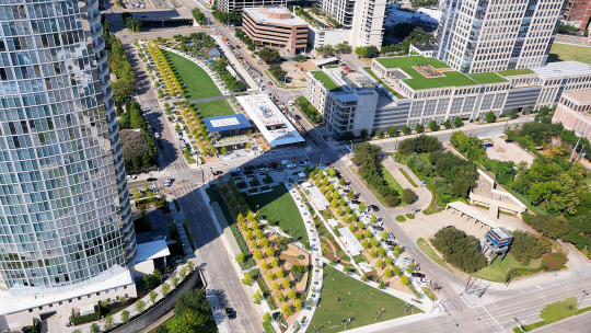
Good - Klyde Warren Park
Downtown Dallas , central gathering space that connects Downtown and Uptown Dallas and succesfully allows visitors to enjoy different types of entertainment.
Different modes of transportation to get there
Rail, bus, rideshare, private car, scooter share program.
Pedestrian Friendly
Food - food trucks
Entertainment Connects - Museums + Conventional Centers

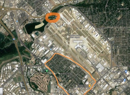
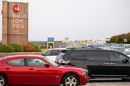
Bad - Dallas Love Field
Dallas Love Field sits surrounded by, Bachman Lake, and by residential neighborhoods. Not having a smooth transition between these spaces, brings unpleasant experiences to the park and neighboorhood. Love Field on its own struggles with congestion by having only one entrance and exit, but because it sits really close to the park and neighborhood, it brings the traffic problem to them but also noise and air pollution.
Nodes
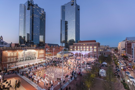
Good - Sundance Square
Organized as a focal point in Fort Worth
Differentiated Space - narrowed streets open up to this square
Can be entered from varying streets leading to the square
Used as a gathering space for events
Surrounded by food, shops and a performance hall

Bad - Casa Linda Plaza
Location: Garland Road and North Buckner Boulevard (East Dallas)
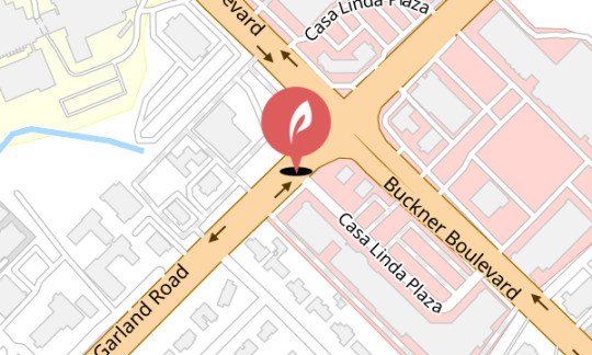
The Spanish Revival Style; opened in 1945; owned by the Brown family for 30 years until Howard Brown’s health declined.
Was Featured in books and popular media
Continuous changes since 2015
Community was “dismayed” by the tree removal.
Fear of the future changes in an attempt to “modernize” the plaza.
Could lose its historical uniqueness and importance

Landmarks
Good - Reunion Tower

Popularly known as “The Ball”; easily recognized by people in Dallas
Memorable
Amazing views from the observation deck
Thirty-two miles away, the city of Fort Worth can be seen on a clear day.
Eventful Dallas ties - fireworks from the reunion tower
Revolving fine-dining restaurant at the top
Easily seen
Unique form - Stands out in the Dallas skyline with its original spherical form on top.
Viewable at night - 259 exterior LED lights
Bad - Campbell Centre Towers
Not known to stand out in the Dallas skyline
Shorter height
Multiple separated buildings lessen the impact of the usual singular form landmark
Not as historically eventful
Exterior
Gold reflective exterior
Reflectiveness creates glare and heat; unattractive in a summer Dallas climate
Less visible at night
1 note
·
View note
Text
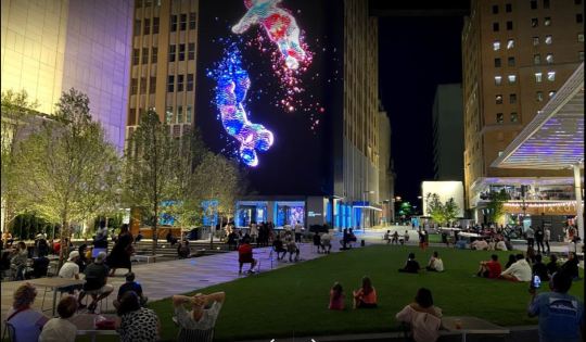
AT&T Discovery District + Whyte’s Plaza Principles
By Renaleigh Aquino & Maylin Juarez

Located at the heart of downtown Dallas, the new AT&T Discovery District aims to connect and bring new experiences to visitors.
The Discovery District mains strengths include being inclusive and sustainable.
RELATIONSHIP TO THE STREET

Public space is at street level
Can be clearly seen from Commerce and Wood street
Unfenced and easy access on four sides
FOOD
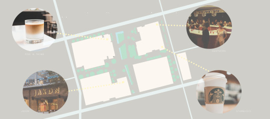
Rise & Thyme
Boutique Cafe, presented by Amanda Freitag. Serving breakfast, pastries, coffee & lattes and fresh lunch options.
Hawthorn
A new steak, seafood and raw bar concept, offering craft cocktails and a private event space.
JAXON
A modern Texas kitchen and beer garden, with BBQ and elevated classic Southern fare.
Starbucks
Inside the AT&T Lobby. Coffee + more!
TRIANGULATION
Bringing people together via programming, events, entertainment and art
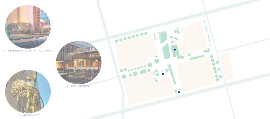
1. Experience Zone and The Grove
An interactive light and sound experience.
Treelined outdoor seating area
2. Beer Garden
Food and outdoor seating
3.Golden Boy
Spirit of Communication is the formal name for a statue originally called Genius of Telegraphy or Genius of Electricity. The statue has been the symbol of AT&T.
Formerly commissioned in sites in New York and New Jersey
WATER

AT&T Discovery District features the use of a smart irrigation and rain water harvesting system.
SITTING

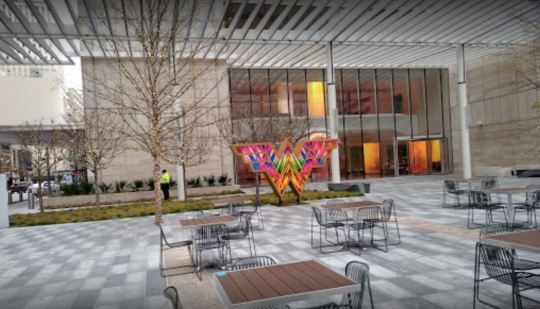
Movable chairs + tables
Grass as a sitting area by the water fountains
BOTH -
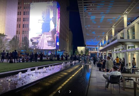
TREES

Trees help create shade in one of the main sitting areas while creating a semi-enclosed space
LIGHT
3/4/2021

Summer solstice - 6/20/2021

Winter solstice - 12/21/2021

https://www.suncalc.org/#/32.7792,-96.7993,19/2021.03.04/12:38/1/3
0 notes
Text
Best Density for the Design of Cities
By Renaleigh Aquino & Maylin Juarez
What’s the best density for the design of cities today ?
We looked into what works best for the design of cities today by looking for characteristics of “good density ” with the best correlation with the
Quality of life
Economic development
Urban quality of life
Natural environment
“Good density” - the Best Density
MIXED USE
A combination of different uses of the land creates a more vibrant urban space
Can be used at all times of the day + welcomes different groups
Residential, commercial, transportation, and green space
INTERCONNECTION
Successful public transportation + infrastructure
LIVEABLE
Enhances the quality of life and livability for residents.
Good public + private services
Safe + security
Welcoming + attractive spaces
SPACIOUS
Well planned city design that prevents crowding
Provides public and open spaces for citizens
ADAPTABLE/FLEXIBLE
Can adapt to changing economic and social circumstances
DESIGNED + PLANNED
High quality urban design
Strategic and specific project choices
Studying what is best for the people
GREEN
Has an environmental benefit
Efficient energy, waste and transport systems
Encourages shared facilities and services
Public transportation
More walking + cycling - reducing fossil fuel use
Is there a specific number of density with an example in DFW?
We don’t believe there is a specific number for the best density but that there are various ideas and concepts that work very well together to bring out a better city. Therefore we also believe that cities with a wide range of densities tend to be more efficient and healthier for people- they are more walkable, transit friendly and tend to provide a wide range of services for the people.
EXAMPLES IN DFW
Pros of living in a denser city - Garland, TX

faster accessibility wide variety of grocery stores and restaurants
access to public transportation
exponential growth in development
low unemployment rate
an abundance of outdoor recreation
aquatics and activity centers
better quality education
lively downtown district
thriving small businesses
Cons of living in a wider spread city - Seagoville, TX
subpar city services
limited retail, restaurant and grocery store selection
few jobs
lacking of public transportation
underdeveloped
RESOURCES
https://www.planetizen.com/node/79342
https://nextcity.org/daily/entry/researchers-calculate-healthiest-city-density#:~:text=Researchers%20nailed%20down%20the%20optimum,spontaneous%20physical%20and%20social%20activities.
https://maps.dcad.org/prd/dpm/
0 notes
Text
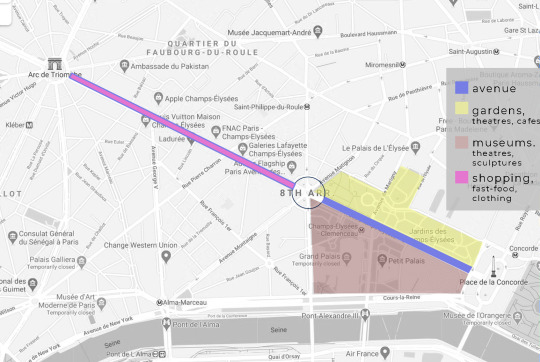
Champs-Elysees (Paris) + Michigan Avenue (Chicago)
By Renaleigh Aquino & Maylin Juarez
We have looked into and analyzed two of the most well known and touristic avenues in the world. With Champs-Elysees Avenue in Paris having about 7 million visitors yearly and the Michigan Avenue in Chicago 22 million.
DIMENSIONS
CHAMPS-ELYSEES AVENUE

MICHIGAN AVENUE

PROGRAM + COMPONENT
CHAMPS-ELYSEES AVENUE
Divided into two parts at the roundabout
-Lower part towards the Place de la Concorde
Gardens
Jardin des champs - elysées
Petit-palais Garden
Museums
Grand palais
Petit palais ( Art museum)
Palais de la découverte (science museum)
Theaters
Espace cardin
Maringy theater
- The upper part towards the arc de triomphe
Shopping side
Fast food
Clothing stores
Luxury shops
MICHIGAN AVENUE
North side - “Magnificent mile”
Oak street beach
Michigan ave bridge over the chicago river
Millennium park - Jay pritzker pavilion
The art institute of chicago
Shops
Transportation
CHAMPS-ELYSEES AVENUE
Walkability

- Extra wide sidewalks (70 ft -wide)
provide the perfect space for cafes and vending.
- Ally of trees along the curb
Helps provide pedestrians with a buffer from car traffic ( 8 lanes) .
MICHIGAN AVENUE
Walkability

- Sidewalks (12ft -wide)
Public transportation
CHAMPS-ELYSEES AVENUE
- Paris metro line
MICHIGAN AVENUE
- buses + subway trains Taxi + water taxi from the Chicago river
Comparing both Champs-Elysees in Paris and Chicago’s Michigan Avenue, we can conclude that the streets function not only for transportation, but also as the connection of historical landmarks and tourist attractions. Tourists and locals travel up and down these streets to experience a significant part of the cities. Along the streets include pedestrian sidewalks increasing the walkability and therefore making the storefronts much more easily accessible. The connection of significant parks, gardens, museums, cafes and shops make these streets create an axis of efficiency and connectivity. Respectively known as the “world’s most beautiful Avenue” and “The Magnificent Mile,” both streets prove that the programming and components of a street can have a significant impact on a city’s urban design by increasing walkability, efficiency and comfortability for local pedestrians and tourists alike.
0 notes
Text
Radiant City - Successes + Failures.
By Renaleigh Aquino & Maylin Juarez

“Radiant city” a proposed urban plan by Le Corbusier in the 1920’s was not only a national urban environmental reform but also a radical social one. Although it was never received and realized, “Radiant City” has been influential in the world of urban planning.
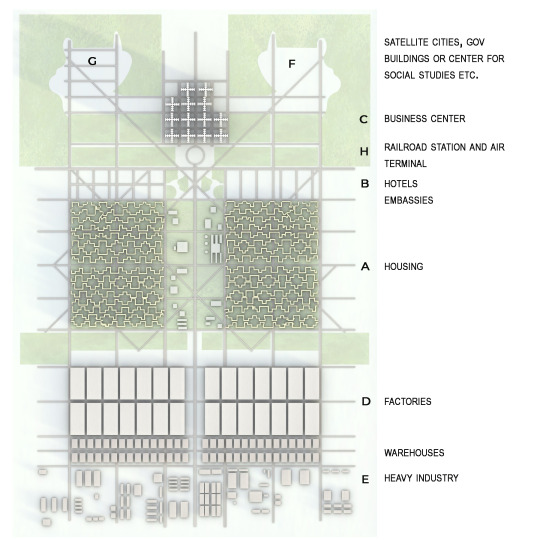
Cons:
Failed to understand basic key elements of human nature made the proposed reform difficult to implement and unrealistic.
His plan suggested the complete destruction and replacement of cities with his concept of perfect, ordered environments.
His ideas had an emphasis on raw uniformed symmetrical geometry, resulting in a very dull, plain design with the possibility of identity and culture loss.

99% Invisible Newsletter
Encouraged industrialized architecture and mass production .
Lack of human scale and connection to its surroundings.
Lack of public spaces
General disregard for livability
Highways were raised above ground, suggesting the separation of highways and paths from green space; it minimizes the interaction with green space.
Pros:
Transportation was planned with the goal of being efficient and saving time.
Vertical construction
more possibilities for green spaces.
Works with a high density population
Promotes an egalitarian approach- having people of different income levels living together.
Plan includes multiple functions
Sunbathing
Basketball
Daycare
Green spaces + sunlight
Became influential in the world of urban planning
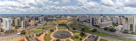
Brasilia
The Economic Times
The separation of work and home
Distance from the dust and pollution of industrial cities
So why was Radiant City an unrealized project?
The Radiant city urban plan is one of the most influential and controversial proposals out there. Having in theory some great goals and ideas that have inspired other urban plans (such as wanting an environmental reform and well-ordered city), the lack of understanding of basic key elements of human nature did not allow for Radiant City to proceed from just a proposal.
Resources
https://urbanutopias.net/2019/06/01/le-corbusier/
https://99percentinvisible.org/article/ville-radieuse-le-corbusiers-functionalist-plan-utopian-radiant-city/
https://www.archdaily.com/411878/ad-classics-ville-radieuse-le-corbusier
0 notes
Text
An “Ideal City" as designers.
By Renaleigh Aquino & Maylin Juarez
“For you, as an architect, what is an “ideal” city? Does an example exist?
The Ideal City
An ideal city is composed of numerous systems that work together to breathe life into a vibrant and livable environment. Three factors that conglomerate into this “Ideal City” should include the following:
People-Oriented Resources: Safety, Healthcare, Welfare
An Environmentally-Conscious Design: Sustainability and Walkability
Lively and Vibrant Attractions: Architecture for the Soul
A city that embodies this idea is Singapore, the world’s only city-island-nation located in Southeast Asia.
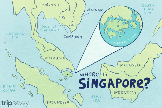
tripsavvy// Ashley Nicole DeLeon
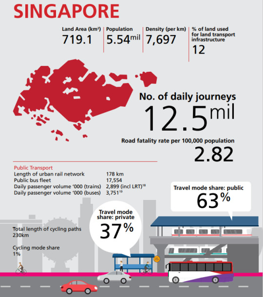
With Singapore’s impressive amount of greenery, excellent public transportation system, strictly enforced hygiene, and strongly sustainably-focused contemporary architecture, this Garden City is one of the most architecturally ideal cities in the world.
People oriented:
A Nation of Homeowners
In 1960 Singapore established the Housing & Development Board (HBD), their public housing authority, to transform the living conditions of the towns and provide quality and affordable housing. Singapore’s public housing program has accommodated the majority of their nation in a home - with 80% of its population living in HBD housing and 90% of those residents owning their home. Singapore has been able to accomplish this by believing that urban design is not only a physical design but also policies that are for the people.
Healthcare
By worldwide standards, Singapore provides a highly efficient healthcare system to their citizens. With their healthcare system they successfully finance and provide high health care results to the community.
Ranked 6th best in healthcare systems by the WHO in 2000
Ranked 1st as the most efficient healthcare system in the world by Bloomberg in 2014
Safety
Singapore is also recognized worldwide for its safety and low crime living conditions.
The U.S. Department of State recognizes Singapore as a LOW-threat location for crime.
The Economist Intelligence Unit 2019 Safe Cities Index - rank Singapore as 1st in the world’s safest city.
An Environmentally-Conscious Design:
Transportation
When a city aims to include alternative modes of transportation it saves money, time and the environment as it relieves traffic congestion and eases development making the city overall more people friendly.
Singapore has been mindful of the negative impacts towards the people and the city that dense traffic results in, and has been working towards other pedestrian and environmentally friendly modes of transportation (walkable, bikeable and public transit).
Walkable and Bikeable Cities, Lessons from Seoul and Singapore
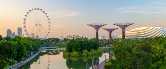
Architecture - “The green city”
Singapore has also taken a lead when it comes to the development of energy-saving technologies and designs. The city-state holds more than a fifth of the floor area as certified green buildings.
Solar panels
Energy-saving elevators + escalators
Highly efficient air-conditioning units + cooling systems
Green facades
Rainwater harvesting
Lighting sensors
High performance window glass
Carbon dioxide emission tracking software

Parkroyal on Pickering - Hotel
By 2030 Singapore aims to have 80% achieve in Green Mark-an environmental performance rating, reducing energy use and carbon emissions.
Lively and Vibrant Attractions: Architecture for the Soul
Food
In Singapore, eating goes beyond survival; it is a way of life, a passion. A large part of this gastronomic culture are Hawker Centres. These semi-enclosed buildings house rows of food stalls with a wide selection of food around the world which can be overwhelming, if not intimidating, to tourists. Although Singapore’s cost of living leans towards the pricier side, food is beneficently affordable. The abundance of restaurants, 24-hour cafes, and wide assortment of food make Singapore one of Asia’s cultural food hubs.
The Global Food Security Index in 2019 ranked Singapore as 1st - world’s best city-country for food security.
Famous Architecture
Singapore is renowned for its innovative and unconventionally sustainable architecture. Home to the world’s largest rooftop infinity pool (Marina Bay Sands), largest indoor waterfall (The Rain Vortex at Jewel in Changi Airport), and a whole city in a garden (Gardens by the Bay), Singapore is an architecturally-rich city.
As the ideal environment to work and live, Singaporean architecture interconnects nature and man by integrating nature into day-to-day living spaces through green roofs, cascading vertical gardens, and verdant walls.
Other Tourist Attractions
Aside from food and contemporary architecture, Singapore allows tourists to venture through its many parks, shop through high-end shopping centers, and visit temples and other historically-built landmarks. Here you can find Singapore’s Universal Studios, Botanical Gardens, Chinatown and the shopping precinct, Orchard Road. There are plenty of attractions making Singapore a popular tourist destination.

Resources:
https://www.hdb.gov.sg/cs/infoweb/about-us
https://www.osac.gov/Country/Singapore/Content/Detail/Report/7f0cc2bc-ba9b-4485-b58b-1861aa0f8fc3#:~:text=Singapore%20remains%20one%20of%20the,Global%20Law%20and%20Order%20report
https://archive.org/details/worldhealthrepor00worl/page/154/mode/2up
https://www.nationalgeographic.com/environment/urban-expeditions/green-buildings/green-urban-landscape-cities-Singapore/
https://www.clc.gov.sg/docs/default-source/books/walkable-and-bikeable-cities.pdf
https://www.seriouseats.com/2011/09/guide-to-singapore-hawker-center-street-food-where-to-eat.html
https://www.cnn.com/style/article/famous-buildings-singapore/index.htmlhttps://www.planetware.com/tourist-attractions/singapore-sin.htm
https://e360.yale.edu/features/singapore_takes_the_lead_in_green_building_in_asia#:~:text=By%20encouraging%20the%20adoption%20of,any%20other%20in%20the%20world.
1 note
·
View note