#mountainsinsrilanka
Text
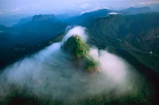
𝐘𝐚𝐡𝐚𝐧𝐠𝐚𝐥𝐚 𝐌𝐨𝐮𝐧𝐭𝐚𝐢𝐧 𝐢𝐧 𝐒𝐫𝐢 𝐋𝐚𝐧𝐤𝐚
In Sri Lanka, Yahangala is a highly well-liked trekking location. Local visitors are more inclined to visit than tourists from other countries. This peak is known as "Bed Rock" by some. It stands at a height of 1220 meters above sea level and is another mountain in the Knuckles Mountain Range. The location is part of Kandy District's Udadumbara Divisional Sectarian region. Additionally, Kandy is 60.2 miles distant (it will take around 1 hour 44 minutes). For people who enjoy hiking, trekking, adventure sports, and camping, this is a fantastic location.
A huge flat region is covered by Yahangala's summit. One of Yahangala's wonders, according to locals, is the absence of large trees. The location is perfect for a campsite and offers breathtaking 360-degree views. From the peak, one can view the "Mahaweli River," "Kehelpathdoruwa," and all three of these landmarks. This object is known as a "yahangala" because of its bed-like appearance. Yahangala is positioned southeast of Knuckles. The topmost part of the Yahangala rock is around two or three acres in size. The entire mountain is exposed to the air, and you may travel both ways. There were no fountains or trees to be found; only broken pieces of stone covered the ground.
𝗥𝗲𝗮𝗱 𝗠𝗼𝗿𝗲:
𝗚𝗼𝗼𝗴𝗹𝗲 𝗠𝗮𝗽:
#YahangalaMountainsSriLanka#MountainsinSriLanka#Knuckles#Camping#MistyMountain#Mountainshunting#Hiking#Kehelapothdoruwa#BedRock#KingRavana#Viewpoint#Travel#Travelsrilanka#Srilanka#Srilankatourism#Ceylon#Paradiseisland#Destination#Nature#naturelover#VisitSriLanka#BeautifulplacesSriLanka#PlacestoVisitSriLanka#Travelisland#HillCountry#Mathale#LonglyVillage#AdventureHike
0 notes
Photo

View of Wellangolla pathana from Kehelpathdoruwa, Kalugala, Sri Lanka 😍❤️ . 📸 Photo courtesy by @manula_w 👈👍👌 . . #travel #instatravel #travelgram #instago #instadaily #thingstodoinsrilanka #visitsrilanka #travelsrilanka #srilankatrip #mountainsinsrilanka #mountains #kalugala #kehelpathdoruwa #wellangollapathana #vacationinsrilanka #srilankatodo #backpacker #backpackers #backpackersrilanka #earthpix #naturephotography #srilanka (at Kalugala, Sri Lanka) https://www.instagram.com/p/CCG6V-IBKv8/?igshid=d08l98iv6r2f
#travel#instatravel#travelgram#instago#instadaily#thingstodoinsrilanka#visitsrilanka#travelsrilanka#srilankatrip#mountainsinsrilanka#mountains#kalugala#kehelpathdoruwa#wellangollapathana#vacationinsrilanka#srilankatodo#backpacker#backpackers#backpackersrilanka#earthpix#naturephotography#srilanka
0 notes
Photo

📸 • @life_of_a_travel_girl Backpacking. It’s more than just slinging a pack over your shoulder and setting off into the wild blue yonder. ⠀⠀⠀⠀⠀⠀⠀⠀⠀ ⠀⠀⠀⠀⠀⠀⠀⠀⠀ It’s a way of seeing the world and interacting with it. It embraces chaos, challenges, and serendipity. It’s wanting to get under the skin of a destination, to get out of your comfort zone, to try new foods, meet new people, and skip the fancy resorts. ⠀⠀⠀⠀⠀⠀⠀⠀⠀ ⠀⠀⠀⠀⠀⠀⠀⠀⠀ I miss backpacking on Friday nights 💔 ⠀⠀⠀⠀⠀⠀⠀⠀⠀ ⠀⠀⠀⠀⠀⠀⠀⠀⠀ #mountainsinsrilanka #hillcountry #favouriteweekends #awakeningmysoul #beautifulsky #inspiredbynature #breathtakingviews #reminiscencing #beautifulmemories #weekendgetaway #srilankatrip #srilankanbeauty #srilankantraveller #srilankantravellerphotography #srilankantravelblogger #skyviewers #skylovers #travelsrilanka #beautifulsrilanka #visitsrilanka #photographywithseylan #yoursrilankatrip #islandofwonders #travelgram #travelholic #travelandexplore #travelcommunity #naturephotography #naturelovers #beautifuldestinations (at Little Adams Peak, Sri Lanka) https://www.instagram.com/p/CBCOerSh8oY/?igshid=1vluv674wgkj6
#mountainsinsrilanka#hillcountry#favouriteweekends#awakeningmysoul#beautifulsky#inspiredbynature#breathtakingviews#reminiscencing#beautifulmemories#weekendgetaway#srilankatrip#srilankanbeauty#srilankantraveller#srilankantravellerphotography#srilankantravelblogger#skyviewers#skylovers#travelsrilanka#beautifulsrilanka#visitsrilanka#photographywithseylan#yoursrilankatrip#islandofwonders#travelgram#travelholic#travelandexplore#travelcommunity#naturephotography#naturelovers#beautifuldestinations
0 notes
Text
𝗔𝗱𝗶𝘀𝗵𝗮𝗺 𝗕𝘂𝗻𝗴𝗮𝗹𝗼𝘄 𝗶𝗻 𝗦𝗿𝗶 𝗟𝗮𝗻𝗸𝗮

Adisham Bungalow or Adisham Hall, a blatant example of colonial history in the nation, was constructed in 1931 close to Haputale in the Badulla District of Sri Lanka. It is a typical English country residence made of stone. Adisham Bungalow currently operates as a venerable Benedictine monastery and has a relic of St. Sylvester in the chapel. Adisham Bungalow is one of the top tourist destinations in Sri Lanka, drawing thousands of visitors each year to its location atop the beautiful mountain ranges in the country's central highlands.
Haputale is around 4 kilometers away from Adisham Bungalow. The monks of the Benedictine order maintain this monastery. Thomas Villers, who was born in Adhisham in 1869, constructed it. On 10 acres of land, R. Booth and F. Webster created the Adisham Bungalow. When Thomas Villers went away in 1959, Pulury conducted his cremation. Every stone that supports Adisham Bungalow has his life narrative engraved into it. A tiny community of six novices and a few monks maintain a program of prayer, meditation, labor, and service at Adisham today, which serves as primarily a monastery. For high-quality goods including strawberry jam, orange marmalade, wild guava jelly, and fresh fruit cordials, Adisham has become renowned.
𝗥𝗲𝗮𝗱 𝗠𝗼𝗿𝗲:
𝗚𝗼𝗼𝗴𝗹𝗲 𝗠𝗮𝗽:
#HaputaleSriLanka#LiptonSeat#AdishamBungalow#Adisham Hall#MountainsinSriLanka#UdaDiyaluma#DiyalumaFalls#DambatenneTeaFactory#Idalgashinna#Thangamale#DevilStaircase#Badulle#Uva#Camping#MistyMountain#Railhike#Mountainshunting#RailwaySriLanka#Hiking#Viewpoint#travel#travelsrilanka#travelphotography#traveladdict#travelingram#travelawesome#Zeloan#srilanka#srilankatravel#srilankatrip
0 notes
Text
𝗔𝗱𝗮𝗺'𝘀 𝗣𝗲𝗮𝗸 𝗦𝗿𝗶 𝗟𝗮𝗻𝗸𝗮
In the picturesque hill region of Sri Lanka, Adams Peak, also known as Sri Pada (or Sacred Footprint), is located next to the little town of Dalhousie (Nallathanniya). Adams Peak, which has a staggering 5,500 steps, has established a reputation as a sacred mountain and attracts a large number of pilgrims because of its spiritual significance. Mountain called Adam's Peak in southwest Sri Lanka. It is situated 11 miles (18 km) northeast of Ratnapura, the Sabaragamuwa province's capital, and is 7,559 feet (2,304 meters) high. The Sri Pada, which translates to "Sacred Footprint" in Sinhala, is a hollow that is 67 inches (170 cm) long and 18 inches (46 cm) broad and looks like the print of a human foot. Buddhists, Hindus, Christians, and Muslims all revere the Sri Pada. Every year, several pilgrims of all religions travel to the top.
The tallest peak in Sri Lanka is Pidurutalagala, not Adam's Peak, but it towers over the surrounding range and resembles a pyramid due to its conical form. Tropical rainforest covers the area around Adam's Peak, and the Peak Wilderness Sanctuary was established as a protection area in 1940. Elephants live there, cut off from the lowlands by the tea farms that surround the sanctuary. Adam's Peak is the source of the Kelani, Walawe, and Kalu, three of Sri Lanka's largest rivers. The summit is notable for being abundant in garnets, rubies, and sapphires and is made of gneiss granite.
𝗥𝗲𝗮𝗱 𝗠𝗼𝗿𝗲:
𝗚𝗼𝗼𝗴𝗹𝗲 𝗠𝗮𝗽:
#AdamsPeakSriLanka#SriPadaya#SriPada#MountainsinSriLanka#SacredFootprint#LordBuddha#GodSaman#NuwaraEliya#Hatton#Dalhousie#CentralProvince#hiking#MistyMountain#Mountainshunting#Sunrise#Viewpoint#travel#travelsrilanka#travelphotography#srilanka#srilankatravel#srilankatrip#srilankatourism#ceylon#paradiseisland#destination#nature#naturelover#VisitSriLanka#BeautifulplacesSriLanka
0 notes
Text
Yahangala Mountain in Sri Lanka

In Sri Lanka, Yahangala is a highly well-liked trekking location. Local visitors are more inclined to visit than tourists from other countries. This peak is known as "Bed Rock" by some. It stands at a height of 1220 meters above sea level and is another mountain in the Knuckles Mountain Range. The location is part of Kandy District's Udadumbara Divisional Sectarian region. Additionally, Kandy is 60.2 miles distant (it will take around 1 hour 44 minutes). For people who enjoy hiking, trekking, adventure sports, and camping, this is a fantastic location.
A huge flat region is covered by Yahangala's summit. One of Yahangala's wonders, according to locals, is the absence of large trees. The location is perfect for a campsite and offers breathtaking 360-degree views. From the peak, one can view the "Mahaweli River," "Kehelpathdoruwa," and all three of these landmarks. This object is known as a "yahangala" because of its bed-like appearance. Yahangala is positioned southeast of Knuckles. The topmost part of the Yahangala rock is around two or three acres in size. The entire mountain is exposed to the air, and you may travel both ways. There were no fountains or trees to be found; only broken pieces of stone covered the ground.
𝗥𝗲𝗮𝗱 𝗠𝗼𝗿𝗲:
𝗚𝗼𝗼𝗴𝗹𝗲 𝗠𝗮𝗽:
#YahangalaMountainsSriLanka#MountainsinSriLanka#Knuckles#Camping#MistyMountain#Mountainshunting#Hiking#Kehelapothdoruwa#BedRock#KingRavana#Viewpoint#Travel#Travelsrilanka#Srilanka#Srilankatourism#Ceylon#Paradiseisland#Destination#Nature#naturelover#VisitSriLanka#BeautifulplacesSriLanka#PlacestoVisitSriLanka#Travelisland#HillCountry#Mathale#LonglyVillage#AdventureHike
0 notes
Text
𝐃𝐨𝐥𝐮𝐤𝐚𝐧𝐝𝐚 𝐌𝐨𝐮𝐧𝐭𝐚𝐢𝐧 𝐢𝐧 𝐒𝐫𝐢 𝐋𝐚𝐧𝐤𝐚

The mountain Dolukanda is located in the Kurunegala District, about 20 kilometers from the city of Kurunegala, near the Hiripitiya hamlet. It rises around 600 meters vertically from the flat plains. Its dimensions are around 2 kilometers long by 0.5 kilometers wide, with a forest reserve on top.
Folklore holds that the Rama-Rawana Legendary Battle served as the starting point for Dolukanda. Lord Rama and his brother Lakshman were both wounded by powerful arrows and knocked out during the battle between Ravana and Lord Rama. In order to preserve their lives, Lord Hanuman was charged with bringing them life-saving herbs from the Himalayas. Because he was unable to recognize the essential plants, he had to transplant a portion of the hill in Sri Lanka that he had previously brought back from India. It is stated that some of the hill's fragments fell on five Sri Lankan places when he was moving it; these areas are believed to be the cities of Dolukanda in the south, Rumasala in the north, Thalladi in Mannar, Ritigala in the east, and Kachchativu in the west. On the other hand, the top of Dolukanda is known as a herbal paradise since a variety of plant species with therapeutic potential may be found there.
𝗥𝗲𝗮𝗱 𝗠𝗼𝗿𝗲:
𝗚𝗼𝗼𝗴𝗹𝗲 𝗠𝗮𝗽:
𝗝𝗼𝗶𝗻 𝗨𝘀:
Facebook - https://www.facebook.com/Zeloantravel
YouTube - https://www.youtube.com/channel/UC5XRFZyJIy9LCdB4eT11Tbg
Pinterest - https://www.pinterest.com/Zeloantravel/
TikTok - https://www.tiktok.com/@zel0an
Instagram - https://www.instagram.com/zeloantravel/
Twitter - https://twitter.com/Zeloantravel
LinkedIn - https://www.linkedin.com/in/zeloan-travel-b68b27243/
Tumblr - https://www.tumblr.com/blog/zeloan
Blogger - https://zeloan.blogspot.com/
Flicker - https://flic.kr/ps/3Z8ugG
Imgur - https://imgur.com/user/ZeloanTravel
Flipboard - https://flipboard.com/@ZeloanTravel
VK - https://vk.com/zeloantravel
Medium - https://medium.com/@Zeloantravel
Reddit - https://www.reddit.com/user/NavinRuvinda
Quora - https://www.quora.com/profile/Zeloan
Rumble - https://rumble.com/user/Zeloan
Vocal - https://vocal.media/authors/zeloan
#DolukandaMountainsSriLanka#DolukadaSanjeewaniMountain#MountainsinSriLanka#Kurunegala#HerbalMountain#ArankeleMonastery#Camping#Mountainshunting#LegendaryMountain#PetroglyphsOfDolukanda#LordHanuman#Hiking#Viewpoint#travel#travelsrilanka#travelphotography#srilanka#srilankatravel#srilankatourism#ceylon#paradiseisland#nature#naturelover#VisitSriLanka#BeautifulplacesSriLanka#PlacestoVisitSriLanka#Travelisland
1 note
·
View note
Text
𝐊𝐨𝐡𝐨𝐧𝐚𝐰𝐚𝐥𝐚 𝐯𝐢𝐥𝐥𝐚𝐠𝐞 𝐢𝐧 𝐒𝐫𝐢 𝐋𝐚𝐧𝐤𝐚

In the Badulla District, Kohonawala hamlet is situated just past the Passara Madulsima mountain range. With its breathtaking views, Kohonawala resembles a fairy tale village. It only receives sunlight for six hours (per day), from 9.00 am to 3.00 pm. The hamlet receives just six hours of sunshine due to the ring of mountains that surround it. As a result, Kohonawala is regarded as a unique settlement by visitors.
Kohonawala can only be reached by foot. It takes at least six hours to walk the 12-kilometer route one way, making it a taxing excursion. Therefore, because the full trip takes a day, it is preferable to start early. However, the breathtaking views along the hamlet's road are worthwhile. The people who live in the village have lovely, independent lives. Semi-farming and crop cultivation provides a living for all 45 households in the community.
𝗥𝗲𝗮𝗱 𝗠𝗼𝗿𝗲:
𝗚𝗼𝗼𝗴𝗹𝗲 𝗠𝗮𝗽:
𝗝𝗼𝗶𝗻 𝗨𝘀:
Facebook - https://www.facebook.com/Zeloantravel
YouTube - https://www.youtube.com/channel/UC5XRFZyJIy9LCdB4eT11Tbg
Pinterest - https://www.pinterest.com/Zeloantravel/
TikTok - https://www.tiktok.com/@zel0an
Instagram - https://www.instagram.com/zeloantravel/
Twitter - https://twitter.com/Zeloantravel
LinkedIn - https://www.linkedin.com/in/zeloan-travel-b68b27243/
Tumblr - https://www.tumblr.com/blog/zeloan
Blogger - https://zeloan.blogspot.com/
Flicker - https://flic.kr/ps/3Z8ugG
Imgur - https://imgur.com/user/ZeloanTravel
Flipboard - https://flipboard.com/@ZeloanTravel
VK - https://vk.com/zeloantravel
Medium - https://medium.com/@Zeloantravel
Reddit - https://www.reddit.com/user/NavinRuvinda
Quora - https://www.quora.com/profile/Zeloan
Rumble - https://rumble.com/user/Zeloan
Vocal - https://vocal.media/authors/zeloan
#KohonawalaVillageSriLanka#Madolsima#LonglyVillage#HiddenVillage#sixhoursunnyvillage#MountainsinSriLanka#Badulle#Uva#Camping#MistyMountain#Mountainshunting#Hiking#Viewpoint#travel#travelsrilanka#travelphotography#srilanka#srilankatourism#ceylon#paradiseisland#destination#nature#VisitSriLanka#BeautifulplacesSriLanka#PlacestoVisitSriLanka#Travelisland#HillCountry
1 note
·
View note
Text
𝐂𝐡𝐚𝐫𝐢𝐨𝐭 𝐏𝐚𝐭𝐡 𝐢𝐧 𝐒𝐫𝐢 𝐋𝐚𝐧𝐤𝐚

The grassland (Plain) known as King Rawana's Chariot Path resembles a route. It is located next to Frotoft Tea Estate in Pussallawa in the Kandy district of the Central Province of Sri Lanka on top of a mountain range encircled by a pygmy forest.
A plain meadow on top of a mountain range that is encircled by a pigmy forest serves as King Ravana's chariot road. According to the legends, this route was first constructed so that King Ravana could utilize his flying chariot, the "Dandu Monaraya," to travel over his realm. According to legends from long ago, he traveled this route to exhibit Queen Seetha of India the splendor, grace, and elegance of his country as well as Sri Lanka.
It is always enjoyable to camp in Sri Lanka's Central Highlands. The outdoors is usually comforting to the mind. The Central Highlands of Sri Lanka provide fantastic camping options. Camping and relaxing time away from modern life distractions are perfect in this undiscovered hidden location.
𝗥𝗲𝗮𝗱 𝗠𝗼𝗿𝗲:
𝗚𝗼𝗼𝗴𝗹𝗲 𝗠𝗮𝗽:
𝗝𝗼𝗶𝗻 𝗨𝘀:
Facebook - https://www.facebook.com/Zeloantravel
YouTube - https://www.youtube.com/channel/UC5XRFZyJIy9LCdB4eT11Tbg
Pinterest - https://www.pinterest.com/Zeloantravel/
TikTok - https://www.tiktok.com/@zel0an
Instagram - https://www.instagram.com/zeloantravel/
Twitter - https://twitter.com/Zeloantravel
LinkedIn - https://www.linkedin.com/in/zeloan-travel-b68b27243/
Tumblr - https://www.tumblr.com/blog/zeloan
Blogger - https://zeloan.blogspot.com/
Flicker - https://flic.kr/ps/3Z8ugG
Imgur - https://imgur.com/user/ZeloanTravel
Flipboard - https://flipboard.com/@ZeloanTravel
VK - https://vk.com/zeloantravel
Medium - https://medium.com/@Zeloantravel
Reddit - https://www.reddit.com/user/NavinRuvinda
Quora - https://www.quora.com/profile/Zeloan
Rumble - https://rumble.com/user/Zeloan
Vocal - https://vocal.media/authors/zeloan
#ChariotPathSriLanka#Pussellawa#Ravana#MountainsinSriLanka#KingRavana#Sitha#Dadumonaraya#Ramayanaya#SithaTearPond#NuwaraEliya#Kandy#Ramboda#Snow#CentralProvince#Camping#MistyMountain#Mountainshunting#OffRoadSriLanka#FrotofotTeaEstate#SambarDeer#MountainLeopards#SriLankanWhiteEye#RhinoHornedLizard#Hiking#Viewpoint#travel#travelsrilanka#travelphotography#traveladdict#travelingram
1 note
·
View note
Text
𝐃𝐚𝐧𝐢𝐠𝐚𝐥𝐚 𝐦𝐨𝐮𝐧𝐭𝐚𝐢𝐧 𝐢𝐧 𝐒𝐫𝐢 𝐋𝐚𝐧𝐤𝐚

Kandegama Rock and Alien Mountain are other names for Danigala Circular Rock. In Sri Lanka's Polonnaruwa district, it is located close to Aralaganwila. The Danigala mountain is 280 meters high (919 ft). the most beautiful location is apart from people. The fog is adding to the valley's splendor as it sets, giving a spectacular 360-degree panorama. It looks like an airport where extraterrestrial spaceships might land when viewed from above. The Pamburugala Kanda, Amunugala Kanda, Hikkagala Kanda, and Henanigala mountain ranges may all be seen from the summit of the Danigala mountain range. Danigala Rock is one of the most difficult mountains to climb.
An archeological reserve called Danigala Rock is located on the Maduru Oya boundary. The Maduru Oya dam is supported by the rocks known as the Danigala and Kamburagala. While Kamburagala rock is located in the Ampara district, Danigala/Kandegama rock is in the Polonnaruwa district. The border between the districts of Polonnaruwa and Ampara is the Maduru Oya.
𝗥𝗲𝗮𝗱 𝗠𝗼𝗿𝗲:
𝗚𝗼𝗼𝗴𝗹𝗲 𝗠𝗮𝗽:
𝗝𝗼𝗶𝗻 𝗨𝘀:
Facebook - https://www.facebook.com/Zeloantravel
YouTube - https://www.youtube.com/channel/UC5XRFZyJIy9LCdB4eT11Tbg
Pinterest - https://www.pinterest.com/Zeloantravel/
TikTok - https://www.tiktok.com/@zel0an
Instagram - https://www.instagram.com/zeloantravel/
Twitter - https://twitter.com/Zeloantravel
LinkedIn - https://www.linkedin.com/in/zeloan-travel-b68b27243/
Tumblr - https://www.tumblr.com/blog/zeloan
Blogger - https://zeloan.blogspot.com/
Flicker - https://flic.kr/ps/3Z8ugG
Imgur - https://imgur.com/user/ZeloanTravel
Flipboard - https://flipboard.com/@ZeloanTravel
VK - https://vk.com/zeloantravel
Medium - https://medium.com/@Zeloantravel
Reddit - https://www.reddit.com/user/NavinRuvinda
Quora - https://www.quora.com/profile/Zeloan
Rumble - https://rumble.com/user/Zeloan
Vocal - https://vocal.media/authors/zeloan
#DanigalaMountainsSriLanka#MountainsinSriLanka#MaduruOya#Pollonaruwa#Camping#CircularRockMountain#Mountainshunting#AlienMountain#PetroglyphsOfDanigala#ErraticBoulder#Hiking#Viewpoint#travel#travelsrilanka#travelphotography#traveladdict#travelingram#travelawesome#Zeloan#srilanka#srilankatravel#srilankatrip#srilankatourism#srilankadaily#srilanka🇱🇰#ceylon#paradiseisland#destination#nature#naturelover
0 notes
Text
𝐇𝐚𝐩𝐮𝐭𝐚𝐥𝐞 𝐢𝐧 𝐒𝐫𝐢 𝐋𝐚𝐧𝐤𝐚

Haputale, which is located in the Badulla District of the Uva Province at a height of 1431 meters above sea level, is part of that region. One of the three main tea-producing regions in Sri Lanka is called Uva, and it stretches from Haputale to Badulla. Haputale is flanked by hills covered in cloud forests and slopes covered with tea plantations. Train travel is one method to explore this region. On the route from Kandy or Nanu Oya (Nuwara Eliya) to Ella or Badulla, there is a train station called Haputale. The Colombo-Badulla route (A16 highway from Beragala to Hali Ela) passes via the Haputale pass, from which a side road leads to Nuwara Eliya. When traveling from the central highlands to the southern beaches, Haputale offers a variety of guesthouses, some of which are extremely elegant and others with breathtaking views, inviting travelers to stay a night or two. For instance, Thotalagala is a seven-suite, opulent boutique hotel. It was previously a residence for tea plantation owners. In the Best Destination Hotel category of the 2017 Condé Nast Johansens Awards for Excellent, Thotalagala took first place. With roughly 5000 people living there, Haputale town is a calm small community. Haputale's climate is chilly but often not frigid because of its altitude.
𝗥𝗲𝗮𝗱 𝗠𝗼𝗿𝗲:
𝗚𝗼𝗼𝗴𝗹𝗲 𝗠𝗮𝗽:
𝗝𝗼𝗶𝗻 𝗨𝘀:
Facebook - https://www.facebook.com/Zeloantravel
YouTube - https://www.youtube.com/channel/UC5XRFZyJIy9LCdB4eT11Tbg
Pinterest - https://www.pinterest.com/Zeloantravel/
TikTok - https://www.tiktok.com/@zel0an
Instagram - https://www.instagram.com/zeloantravel/
Twitter - https://twitter.com/Zeloantravel
LinkedIn - https://www.linkedin.com/in/zeloan-travel-b68b27243/
Tumblr - https://www.tumblr.com/blog/zeloan
Blogger - https://zeloan.blogspot.com/
Flicker - https://flic.kr/ps/3Z8ugG
Imgur - https://imgur.com/user/ZeloanTravel
Flipboard - https://flipboard.com/@ZeloanTravel
VK - https://vk.com/zeloantravel
Medium - https://medium.com/@Zeloantravel
Reddit - https://www.reddit.com/user/NavinRuvinda
Quora - https://www.quora.com/profile/Zeloan
#HaputaleSriLanka#LiptonSeat#AdishamBungalow#MountainsinSriLanka#UdaDiyaluma#DiyalumaFalls#DambatenneTeaFactory#Idalgashinna#Thangamale#DevilStaircase#Badulle#Uva#Camping#MistyMountain#Railhike#Mountainshunting#RailwaySriLanka#Hiking#Viewpoint#travel#travelsrilanka#travelphotography#traveladdict#travelingram#travelawesome#Zeloan#srilanka#srilankatravel#srilankatrip#srilankatourism
0 notes
Text
𝐄𝐥𝐥𝐚 𝐎𝐝𝐲𝐬𝐬𝐞𝐲 𝐓𝐫𝐚𝐢𝐧 𝐢𝐧 𝐒𝐫𝐢 𝐋𝐚𝐧𝐤𝐚
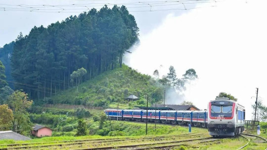
A brand-new, opulent train service called the Ella Odyssey travels daily between Kandy and Ella. Launched on March 5, 2022, this is a relatively recent addition to the Sri Lankan railway network. On its journey to Demodara station, Ella Odyssey makes a number of breathtaking pit stops. In particular, this unique train makes stops at nine well-liked tourist destinations in addition to major rail hubs. At these views, passengers are free to disembark and take pictures of the surrounding scenery.
One of the most beautiful train trips in the world is that between Kandy and Ella. This 7-hour trip is unquestionably a must-do activity in Sri Lanka. The spectacular scenery and mountain vistas along the railway route are unmatched. The thrilling trip continues over bridges and under tunnels with breathtaking views of mist-covered mountains, magnificent waterfalls, and lush green slopes covered with tea plantations. It will be beautiful outside your window throughout!
𝗥𝗲𝗮𝗱 𝗠𝗼𝗿𝗲:
𝐓𝐢𝐜𝐤𝐞𝐭 𝐁𝐨𝐨𝐤𝐢𝐧𝐠:
𝗝𝗼𝗶𝗻 𝗨𝘀:
Facebook - https://www.facebook.com/Zeloantravel
YouTube - https://www.youtube.com/channel/UC5XRFZyJIy9LCdB4eT11Tbg
Pinterest - https://www.pinterest.com/Zeloantravel/
TikTok - https://www.tiktok.com/@zel0an
Instagram - https://www.instagram.com/zeloantravel/
Twitter - https://twitter.com/Zeloantravel
LinkedIn - https://www.linkedin.com/in/zeloan-travel-b68b27243/
Tumblr - https://www.tumblr.com/blog/zeloan
Blogger - https://zeloan.blogspot.com/
Flicker - https://flic.kr/ps/3Z8ugG
Imgur - https://imgur.com/user/ZeloanTravel
Flipboard - https://flipboard.com/@ZeloanTravel
VK - https://vk.com/zeloantravel
Medium - https://medium.com/@Zeloantravel
Reddit - https://www.reddit.com/user/NavinRuvinda
Quora - https://www.quora.com/profile/Zeloan
#EllaOdysseyTrain#SummitPoint#St.clairWaterfall#Demodara#Luxurytrain#Ella#Kandy#9ArchBridge#IdalgashinnaSriLanka#IdalgashinnaStation#MountainsinSriLanka#Idalgashinna#Uva#Train#MistyMountain#Railhike#Mountainshunting#RailwaySriLanka#Hiking#Viewpoint#travel#travelsrilanka#travelphotography#traveladdict#travelingram#travelawesome#Zeloan#srilanka#srilankatravel#srilankatrip
0 notes
Text
𝐈𝐝𝐚𝐥𝐠𝐚𝐬𝐡𝐢𝐧𝐧𝐚 𝐢𝐧 𝐒𝐫𝐢 𝐋𝐚𝐧𝐤𝐚

Idalgashinna is a little hamlet in Sri Lanka's Uva Province's Badulla District. It is situated in the Haputale-Namunukula mountain range at a height of approximately 1,615 meters (5,299 feet) above sea level. The Idalgashinna Estate is located in this region, and the closest significant town is Haputale, which is located approximately 9 kilometers south on the railway. The Thangamale Bird Sanctuary is situated between these two locations. The Welimada Divisional Secretariat oversees education in the region and is responsible for Idalgashinna Tamil Vidyalaya (Idalgashinna Tamil College), Beauvais Tamil Vidyalaya, and Ellethota Vidyalaya.
Despite brief periods of habitation earlier, Idalgashinna was first developed as a tea estate in 1984. The Idalgashinna Pass is a notable natural feature in the region. The Portuguese attempted to exploit the pass in their campaigns against the Kingdom of Kandy in the 16th century since it was thought to be a crucial gateway to the highland regions.
Idalgashinna Railway Station, the fifth-highest railway station in Sri Lanka and the 68th station on the Main Line, is situated between the Haputale and Ohiya Railway Stations in the Badulla District of the Uva Province. It is situated at an altitude of 1,615 meters (5,299 feet) above sea level, 8 kilometers (5.0 miles) west of Haputale. Following the track's extension from the Nanu Oya railway station to Haputale in 1893, the station was constructed. On the railway between Colombo and Badulla, this is station number 68. The railway station is situated on a hill that divides Sri Lanka's southern and eastern regions. As a result, the surroundings are both perpetually foggy and immediately clear. Rainwater from the Idalgashinna railway station accumulates in front of the roof to the Mahaweli river valley and falls to the Walawe river valley, depending on the position.
𝗥𝗲𝗮𝗱 𝗠𝗼𝗿𝗲:
𝗚𝗼𝗼𝗴𝗹𝗲 𝗠𝗮𝗽:
𝗝𝗼𝗶𝗻 𝗨𝘀:
Facebook - https://www.facebook.com/Zeloantravel
YouTube - https://www.youtube.com/channel/UC5XRFZyJIy9LCdB4eT11Tbg
Pinterest - https://www.pinterest.com/Zeloantravel/
TikTok - https://www.tiktok.com/@zel0an
Instagram - https://www.instagram.com/zeloantravel/
Twitter - https://twitter.com/Zeloantravel
LinkedIn - https://www.linkedin.com/in/zeloan-travel-b68b27243/
Tumblr - https://www.tumblr.com/blog/zeloan
Blogger - https://zeloan.blogspot.com/
Flicker - https://flic.kr/ps/3Z8ugG
Imgur - https://imgur.com/user/ZeloanTravel
Flipboard - https://flipboard.com/@ZeloanTravel
VK - https://vk.com/zeloantravel
Medium - https://medium.com/@Zeloantravel
Reddit - https://www.reddit.com/user/NavinRuvinda
Quora - https://www.quora.com/profile/Zeloan
#IdalgashinnaSriLanka#IdalgashinnaStation#MountainsinSriLanka#Idalgashinna#IdalgashinnatoOhiya#Badulle#Uva#Camping#MistyMountain#Railhike#Mountainshunting#RailwaySriLanka#Hiking#Viewpoint#travel#travelsrilanka#travelphotography#traveladdict#travelingram#travelawesome#Zeloan#srilanka#srilankatravel#srilankatrip#srilankatourism#srilankadaily#srilanka🇱🇰#ceylon#paradiseisland#destination
0 notes
Text
Meemure in Sri Lanka

Meemure is a remote community in Sri Lanka's Central Province that is nestled 324 meters above sea level in the mountains. It can only be accessed from the "Hunnasgiriya" mountain, which is a part of the Knuckles range and is located around 50 kilometers from Kandy. The 33 km trek from Hunnasgiriya to Meemure is challenging with many challenging parts, but the scenery is wonderful. The settlement itself receives an abundance of water in the form of waterfalls that originate in the Knuckles' evergreen forests. The pyramid-shaped Lakegala mountain is located east of the settlement, and the magnificent Knuckles range dominates the west. Meemure's southern and northern boundaries are separated by the Heen River and a forest that extends to the "Pitawala Pathana" grassland.
Up until 2004, pack-bulls were the only means of transportation to Meemure. Cattle herds delivered supplies and equipment to the settlement in bags. Because of the village's abundance and wealth, pack-bulls were exclusively used to transport salt, textiles, tobacco, and calcium bicarbonate. However, the trails have been extended to accommodate three-wheelers, jeeps, and compact trucks due to the invasion of modern technology.
𝗥𝗲𝗮𝗱 𝗠𝗼𝗿𝗲:
https://zeloan.blogspot.com/2022/08/meemure-in-sri-lanka.html
𝗚𝗼𝗼𝗴𝗹𝗲 𝗠𝗮𝗽:
https://goo.gl/maps/N6Ccqj6Hq888NR8L6
𝗝𝗼𝗶𝗻 𝗨𝘀:
Facebook - https://www.facebook.com/Zeloantravel
YouTube - https://www.youtube.com/channel/UC5XRFZyJIy9LCdB4eT11Tbg
Pinterest - https://www.pinterest.com/Zeloantravel/
TikTok - https://www.tiktok.com/@zel0an
Instagram - https://www.instagram.com/zeloantravel/
Twitter - https://twitter.com/Zeloantravel
LinkedIn - https://www.linkedin.com/in/zeloan-travel-b68b27243/
Tumblr - https://www.tumblr.com/blog/zeloan
Blogger - https://zeloan.blogspot.com/
Flicker - https://flic.kr/ps/3Z8ugG
Imgur - https://imgur.com/user/ZeloanTravel
Flipboard - https://flipboard.com/@ZeloanTravel
VK - vk.com/id735880267
Medium - https://medium.com/@Zeloantravel
Reddit - https://www.reddit.com/user/NavinRuvinda
Quora - https://www.quora.com/profile/Zeloan
#LakegalaMountainsSriLanka#MountainsinSriLanka#Meemure#Knuckles#Camping#MistyMountain#Mountainshunting#waterfallSriLanka#Hiking#Viewpoint#travel#travelsrilanka#travelphotography#traveladdict#travelingram#travelawesome#Zeloan#srilanka#srilankatravel#srilankatrip#srilankatourism#srilankadaily#srilanka🇱🇰#ceylon#paradiseisland#destination#nature#naturelover#naturephotography#waterfalls
0 notes
Text
Kabaragala Mountain in Sri Lanka

In Sri Lanka's Dolosbage Mountain Range, Kabaragala is the mountain's highest summit. This is situated where the districts of Kagalle and Kandy meet. The summit rises 1506 meters above sea level. Similar to the Horton Plains, it has an almost level topography. Moreover, a massive fallout akin to the Word End. It is situated in Sri Lanka's Sabaragamuwa Province. The mountain range is known as Kabaragala, according to the locals, because of its speckled iguana-like appearance. On one side of the mountain, when you reach the peak, a steep slope may be seen on the opposite side. You may ascend the mountain farther to view a number of interesting locations. The natural forest and grasslands at the top of the hill contribute to the splendor of the mountains. A windbreak that produces an endless stream of winds is also present. The natural environment may be explored quite well here.
Starting from Maryville Junction, the trek will go. The concrete road leading to the mountain and a Kovil are your first two encounters. You will then arrive to a tea estate. Your path will now get shorter and you'll be traveling along a short footpath. But it is easy to recognize. You will then enter a tiny pine tree forest. You may reach the first viewing point after an hour of walking. It truly is fantastic. You may view beautiful images of the area.
Most travelers complete their trek at the vista point. But in order to reach the peak, you should go on. The Horton Plains' surface is remarkably similar to the landscape. Mana trees and vegetation like the Sahara may be seen. The steep descent to the bottom is comparable to the end of the world. You can reach the Kabaragala Mountains' top after over two hours of climbing. The panorama from the peak is really breathtaking. You'll definitely be astounded!
𝗥𝗲𝗮𝗱 𝗠𝗼𝗿𝗲:
𝗚𝗼𝗼𝗴𝗹𝗲 𝗠𝗮𝗽:
𝗝𝗼𝗶𝗻 𝗨𝘀:
Facebook - https://www.facebook.com/Zeloantravel
YouTube - https://www.youtube.com/channel/UC5XRFZyJIy9LCdB4eT11Tbg
Pinterest - https://www.pinterest.com/Zeloantravel/
TikTok - https://www.tiktok.com/@zel0an
Instagram - https://www.instagram.com/zeloantravel/
Twitter - https://twitter.com/Zeloantravel
LinkedIn - https://www.linkedin.com/in/zeloan-travel-b68b27243/
Tumblr - https://www.tumblr.com/blog/zeloan
Blogger - https://zeloan.blogspot.com/
Flicker - https://flic.kr/ps/3Z8ugG
Imgur - https://imgur.com/user/ZeloanTravel
Flipboard - https://flipboard.com/@ZeloanTravel
VK - vk.com/id735880267
Medium - https://medium.com/@Zeloantravel
Reddit - https://www.reddit.com/user/NavinRuvinda
Quora - https://www.quora.com/profile/Zeloan
#KabaragalaMountainsSriLanka#MountainsinSriLanka#Dolbage#Kegalle#Camping#MistyMountain#Mountainshunting#waterfallSriLanka#Hiking#Viewpoint#travel#travelsrilanka#travelphotography#traveladdict#travelingram#travelawesome#Zeloan#srilanka#srilankatravel#srilankatrip#srilankatourism#srilankadaily#srilanka🇱🇰#ceylon#paradiseisland#destination#nature#naturelover#naturephotography#waterfalls
0 notes
Photo

'Haritha Kanda' Mountain, Bogawanthalawa, Sri Lanka 😍❤️ . 📸 Photo courtesy by @sameerakgg_traveler 👈👍👌 . #travel #instatravel #travelgram #instago #instadaily #thingstodoinsrilanka #visitsrilanka #travelsrilanka #srilankatrip #srilankatravel #srilankadaily #srilankatourism #exploresrilanka #attractionssrilanka #srilankan #srilankadiaries #triptosrilanka #holidayinsrilanka #vacationinsrilanka #srilankatodo #backpacker #backpackers #mountains #mountainsinsrilanka #hiking #trekking #camping #harithakanda #srilanka #lka (at Haritha Kanda, Bogawanthalawa) https://www.instagram.com/p/CGG1WJQhpsz/?igshid=1e4p52qva9b0c
#travel#instatravel#travelgram#instago#instadaily#thingstodoinsrilanka#visitsrilanka#travelsrilanka#srilankatrip#srilankatravel#srilankadaily#srilankatourism#exploresrilanka#attractionssrilanka#srilankan#srilankadiaries#triptosrilanka#holidayinsrilanka#vacationinsrilanka#srilankatodo#backpacker#backpackers#mountains#mountainsinsrilanka#hiking#trekking#camping#harithakanda#srilanka#lka
0 notes
Last Seen Blogs

kuramiluna
Ur kawaii senpai

arjhayeortega-blog
Hack Life

bunnyberrymilk
𝕊𝕒𝕥𝕒𝕟’𝕤 𝔹𝕒𝕓𝕪𝕘𝕚𝕣𝕝

cheesecheesecheeseeee
Clarisse Pantoja

olovr
olive