#Wishtoyo Chumash Foundation.
Link


Excerpt from this story from The Signal from the Santa Clarita Valley:
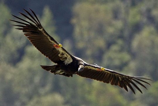
For decades, we’ve fought to save California condors from extinction. After 40 years of protection, these magnificent birds are slowly recovering. But they remain among the world’s most imperiled animals.
While condors are iconic to all Californians, they’re especially important to native people. Condors appear in cave paintings, traditional stories, oral histories, and both ancient and contemporary Native California ceremonies and regalia. For millennia, they’ve been integral to the cultures and religions of indigenous peoples, including the Chumash.
We have a sacred responsibility to protect our condor relatives. That’s why Chumash people have actively taken part in both bringing the last 22 California condors into the captive breeding program and in holding ceremonies for the release of condors as the program became successful.
Yet now condors may lose one of their most important remaining habitats because the federal government has approved a massive new Kern County development in the heart of condor country, not far from Santa Clarita.
Approval of this development, Tejon Mountain Village, by federal wildlife officials flies in the face of our native cultural practices and the condor’s needs.
The proposed luxury resort would destroy 28,500 acres of pristine habitat crucial for the condors’ recovery. The proposed buildout includes two golf courses, an equestrian center, up to 3,450 residences and 750 high-end hotel rooms.
In April, Wishtoyo Foundation joined indigenous and conservation groups in suing the U.S. Fish and Wildlife Service for authorizing the plan. The service approved the plan some years ago, but with construction now imminent, we had to act.
Despite its legal obligation under the National Historic Preservation Act, the service didn’t adequately consult native people on the religious and cultural significance of condors. We demand to be heard on Tejon Mountain Village’s threat to these birds and our culture.
2 notes
·
View notes
Photo

Trump administration settles lawsuit, agrees to protect humpback whale habitat
Peter Fimrite - August 24, 2018
The Trump administration agreed Friday to protect humpback whale habitat in the Pacific Ocean after American Indian and conservation groups sued the government for leaving the playful leviathans vulnerable to ship strikes, oil spills and entanglements in fishing gear.
The suit by the Center for Biological Diversity, Turtle Island Restoration Network and the Wishtoyo Chumash Foundation, a nonprofit that represents American Indian tribes, was settled Friday in federal court in San Francisco.
The National Marine Fisheries Service agreed to designate critical habitat for the animals by mid-2019 and finalize those boundaries a year later. It means the migration routes of three endangered or threatened populations of humpbacks on the West Coast will be protected.
“This agreement ensures the whales will finally get the protections they need,” said Catherine Kilduff, a lawyer for the Center for Biological Diversity.
The suit, filed in March, accused the administration of seeking to expand offshore oil and gas drilling instead of protecting whales in California, where they have been seen recently splashing around near Fort Point in San Francisco Bay and under the Golden Gate Bridge.
“Once again, when we challenged the Trump administration’s attempt to illegally ignore environmental law in court, the Trump administration has been forced to change course,” said Todd Steiner, the executive director of Turtle Island Restoration Network.
Humpbacks often get tangled in fishing gear around Monterey Bay, where the migrating whales come to feed. Vessel collisions have also become a major cause of death outside the Golden Gate, where 7,300 large vessels pass every year. An estimated 22 humpbacks are killed by ships off the coasts of California, Oregon and Washington each year, according to a recent study.
Disasters such as the 2015 Refugio oil spill, which dumped 142,800 gallons of crude in the coastal waters off Santa Barbara, are also a problem for humpbacks, which were observed swimming through the sheen left by the pipeline rupture.
Alicia Cordero of the Wishtoyo Chumash Foundation said “critical habitat is essential” for “our humpback whale relatives” who have shared the Santa Barbara Channel with the tribe for thousands of years.
In 2016, the NOAA’s fisheries service delisted nine of the 14 subspecies of humpbacks that were put under the Endangered Species Act in 1973.
Although the move was touted as an ecological success story, the plaintiffs in the lawsuit pointed out that the humpback subspecies seen along the California coast were still suffering compared to their cohorts in the rest of the world.
The Central American population, which migrates twice annually along the California coast past San Francisco, remained on the endangered list after only 411 animals were counted. The Mexico population, which feeds off the West Coast and Alaska, was downgraded from endangered to threatened, even though experts determined that many of the 3,200 whales were dying from entanglements in commercial fishing gear.
The species, famous for putting on spectacular displays of leaping and splashing, was nearly wiped out by commercial hunting in the 19th and 20th centuries. Before 1900, an estimated 15,000 humpbacks lived in the North Pacific. In the 20th century, their numbers dwindled to fewer than 1,000.
The International Whaling Commission’s hunting ban, imposed in 1982, played a major role in the comeback. Between 75,000 and 80,000 humpbacks now live in the world’s oceans, and many of those survivors migrate through the Greater Farallones National Marine Sanctuary.
Humpbacks have had a special place in Bay Area hearts since Humphrey, a 40-ton humpback, caused pandemonium in 1985 when he swam through the Carquinez Strait, up the Sacramento River and into a creek near Rio Vista. He went back to sea after 25 days.
47 notes
·
View notes
Photo
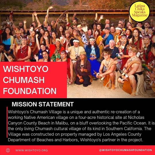
❤ COMMUNITY ORGANIZATION SPOTLIGHT: @wishtoyochumashfoundation ❤ MISSION STATEMENT: Wishtoyo's Chumash Village is a unique and authentic re-creation of a working Native American village on a four-acre historical site at Nicholas Canyon County Beach in Malibu, on a bluff overlooking the Pacific Ocean. It is the only living Chumash cultural village of its kind in Southern California. The Village was constructed on property managed by Los Angeles County Department of Beaches and Harbors, Wishtoyo's partner in the project. . . . #communitysupport #indigenous #indigenouscommunities #indigenouscommunity #latinocommunity #latinxcommunity #latinos #latinxs #latinx #latino #poc #communitiesofcolor #socialjustice #socialchange #indigenouscommunities #autonomy #mutualaid #nonprofit #foundation #foundationsupport #latinachikaspeaksmagazine https://www.instagram.com/p/CQ_jg3YJ_5x/?utm_medium=tumblr
#communitysupport#indigenous#indigenouscommunities#indigenouscommunity#latinocommunity#latinxcommunity#latinos#latinxs#latinx#latino#poc#communitiesofcolor#socialjustice#socialchange#autonomy#mutualaid#nonprofit#foundation#foundationsupport#latinachikaspeaksmagazine
0 notes
Text
Malibu's Beaches: The Ultimate Guide
New Post has been published on https://www.usatelegraph.com/2018/malibus-beaches-ultimate-guide/
Malibu's Beaches: The Ultimate Guide
01of 17
A Guide to the 27 Miles of Malibu Beaches
•••
The city of Malibu is home to 27 miles of the most gorgeous beaches in Los Angeles County. There are 13 major named beaches with 29 local designations along this stretch of mostly south-facing coastline.
Several of Malibu’s most beautiful beaches including Leo Carillo State Park, Malibu Lagoon State Beach and the three beaches in the Robert H. Meyer Memorial Beach are managed by the state and accept the annual state parking pass. Leo Carillo also offers beach-adjacent camping.
Beach Regulations
These things are prohibited on ALL Malibu beaches unless otherwise noted:
Smoking
Alcohol
Nude (or topless for women) sunbathing
Pets of any kind
Camping or sleeping
Fires or barbecues (except where fire pits or barbecues are provided)
Fireworks
Amplified music
Throwing balls in crowded areas (outside of ball courts) where you might hit other people
All of Malibu’s beaches are public, despite what some home owners would like you to believe. Coastal access advocates have succeeded in getting beach access points added in some of the more controversial areas, but there are no public amenities, very limited parking and often very little sand during high tide, so they don’t make the top list. You can check out the Our Malibu Beaches App if you want to find those tricky access points.
The beaches here are listed in order from north to south down the coast.
02of 17
Leo Carillo State Beach
•••
Leo Carillo State Park actually begins at County Line Beach in Ventura County, but most of its 1.5 miles of beach is within Los Angeles County at the northern end of Malibu. Leo Carillo includes three beaches that range from wide, sandy stretched to rocky tide pools.
The longest stretch is South Beach, which begins where the pedestrian tunnel crosses under Pacific Coast Highway and extends southward in a wide sandy arc. To the north of the tunnel is a series of four coves which can be accessed from the sand at low tide, or from stairways down from the bluff. The series of coves ends at Sequit Point, where there are some caves that can be explored at low tide.
North Beach is the stretch of sandy beach north of Sequit Point which can be accessed from a parking lot directly on the beach. North Beach allows dogs north of lifeguard towas long as they’re on leash.
The limited-access rocky beach north of North Beach is known as Staircase Beach, although it has no stairs. You can walk there from North Beach at low tide, or hike down a trail from a small lot near the park manager’s residence at 40000 Pacific Coast Highway.
Leo Carillo State Park includes an RV park, campground and day use parking lot with tunnel access under Pacific Coast Highway to the beaches. There is an Educational and Interpretive Center with exhibits on tidepools and gray whales.
Hiking trails into the canyons and mountains include the Leo Carrillo Beach Trail (moderate), Yellow Hill Trail (easy) and Nicholas Flat Trail (hard).
The park was named after Leo Carrillo (1880-1961), actor, preservationist and conservationist who served on the California Beach and Parks commission for eighteen years. Carillo was best known for playing Pancho, the sidekick to Duncan Renaldo’s Cisco Kid, an early 1950’s TV series.
Address: 35000 West Pacific Coast Highway, Malibu, CA 90265
Environment:
Parking: There are two pay lots that accept the California Explorer State Parks Annual Pass or has an hourly or daily fee to park. For the North Beach lot, you continue past the south Beach and camping lot above PCH and cross under PCH to the beach lot. There is also a limited amount of free parking on Pacific Coast Highway.
Handicapped parking (2 spaces) near the restrooms and 3 spaces near the entrance in the North Beach parking lot. There are 3 spaces near the beach underpass and 2 near the Visitor Center in the South Beach parking lot.
Public Transportation: not available
Amenities
Restrooms: Permanent restrooms at South Beach and at the north end of the North Beach parking lot.
Showers: token operated showers at South Beach or camp ground
Lifeguards: yes
Bike Path: no
Fire Pits: no, BBQ grills at the south end of the North Beach parking lot
Volleyball Courts: no
Playground: no
Gymnastics Equipment: no
Food: camp store
Picnic Facilities: yes, picnic tables and BBQs at the North Beach parking lot.
Activities
Surfing: yes
Swimming: yes
Diving: yes
Fishing: yes
Biking: no
Other: RV parking, tent camping,hiking trails, boating, visitor center, windsurfing, vista point, geocaching, leashed dogs on North Beach only
03of 17
Nicholas Canyon Beach
•••
Nicholas Canyon Beach is a County beach that runs for about a mile south of Leo Carillo South Beach. The narrow strip of sand sits at the foot of a steep bluff and is a bit of a trek from both the upper and lower parking lots, so it doesn’t get as crowded as some of the other Malibu beaches. At the southeast end, the beach runs into a rocky bluff topped by Malibu mansions.
There are stairs and trails down to the beach. There are several picnic tables at a viewpoint just below the parking lot and a few more at the bottom of the beach ramp near the restrooms.
The beach is known as Zeros Beach or Point Zero to local surfers. It has one of the few perfect point breaks left in Los Angeles County where you can watch the waves line up when the tide is coming in.
Adjacent to the parking lot at the top of the hill, the Wishtoyo Foundation has created a Chumash Native American village.It can only be visited by appointment or during special events, but you can see the structures through the fence.
Address: 33850 Pacific Coast Highway, Malibu, CA 90265
Parking: There is limited free street parking on Pacific Coast Highway and a County pay lot on the beach side of PCH on top of the bluff. Parking rates vary from $3 to $10 depending on the season. The entrance is marked by a concrete sign under some trees and is easy to miss in the shadows.
Public Transportation: none
Amenities
Restrooms: Yes, building at the bottom of the ramp, portable toilets at the top near the lifeguard tower.
Showers: Yes
Lifeguards: In season
Bike Path: no
Fire Pits: no
Volleyball Courts: No
Playground: no
Gymnastics Equipment: no
Food: No
Picnic Facilities: yes
Activities
Surfing: yes
Body Surfing: yes
Swimming: yes
Diving: yes
Fishing: yes
Biking: no
Other: windsailing, tide pools, Chumash Village
04of 17
El Pescador State Beach
El Pescador Beach is the westernmost of three scenic pocket beaches that make up the Robert H. Meyer Memorial State Beach. It it a crescent-shaped stretch of sand at the bottom of a bluff with rocky tide pool areas at each end. There is a stepped trail or wooden stairway down to the beach from the parking lot. Although there are no restrictions to surfing, diving, fishing or windsurfing at these three beaches, it’s a long way to tote gear, so you won’t see a lot of that here.
Address: 32860 Pacific Coast Hwy, Malibu, CA 90265
Parking: There is limited free street parking on Pacific Coast Highway and a pay lot on the south side of Pacific Cost Highway. This beach accepts the California Explorer State Parks Annual Pass or has an hourly or daily fee to park.
Public Transportation: no
Amenities
Restrooms: Portable toilets
Showers: no
Lifeguards: no
Bike Path: no
Fire Pits: no
Volleyball Courts: no
Playground: no
Gymnastics Equipment: no
Food: no
Picnic Facilities: yes
Activities
Surfing: permitted, but uncommon
Swimming: yes
Diving: permitted, but uncommon
Fishing: permitted, but uncommon
Biking: no
Other: wildlife viewing, hiking trails, tide pools
05of 17
La Piedra Beach
•••
La Piedra Beach is the middle cove of the Robert H. Meyer Memorial State Beach. the parking is on top of the bluff with a long, steep trail down to the beach. It’s especially scenic in the spring with the wildflowers in bloom. Because of the challenging access and small parking lot, it doesn’t tend to be overly crowded.
Address:
Parking: There is limited free street parking on Pacific Coast Highway and a pay lot on the south side of Pacific Cost Highway. This beach accepts the California Explorer State Parks Annual Pass or has an hourly or daily fee to park.
Public Transportation: none
Amenities
Restrooms: portable toilets
Showers: no
Lifeguards: no
Bike Path: no
Fire Pits: no
Volleyball Courts: no
Playground: no
Gymnastics Equipment: no
Food: no
Picnic Facilities: yes
Activities
Surfing: permitted, but uncommon
Swimming: yes
Diving: permitted, but uncommon
Fishing: permitted, but uncommon
Biking: no
Other: wildlife viewing, hiking trails, tide pools
06of 17
El Matador Beach
•••
El Matador Beach is the most popular of the three coves at Robert H. Meyer Memorial State Beach due to it’s incredibly scenic arches and rock formations. It’s a popular spot for photo shoots, but a permit is required for professional photography. The beach is accessed by a trail that leads to stairs down to the bottom. There are picnic tables around the parking area where you can enjoy the view from above.
You can walk from Matador Beach southeast to Lechuza Beach and Broad Beach, which run along the front of mansions and beach houses with no parking lot access. There are a few public access points to Lechuza and Broad Beaches, but parking on PCH is tricky.
Address: 32200 Pacific Coast Highway, Malibu, CA 90265
Parking: There is limited free street parking on Pacific Coast Highway and a pay lot on the south side of Pacific Cost Highway. This beach accepts the California Explorer State Parks Annual Pass or has an hourly or daily fee to park.
Public Transportation: None
Amenities
Restrooms: portable toilets
Showers: no
Lifeguards: no
Bike Path: no
Fire Pits: no
Volleyball Courts:
Playground: no
Gymnastics Equipment: no
Food: no
Picnic Facilities: yes
Activities
Surfing: permitted, but uncommon
Swimming: yes
Diving: permitted, but uncommon
Fishing: permitted, but uncommon
Biking: no
Other: wildlife viewing, hiking trails, tide pools, photography
07of 17
Zuma Beach
•••
Zuma County Beach is a 1.8 mile stretch of wide, flat beach with a vast beachfront parking lot with 2000 spaces. There are beachfront restrooms, showers and concessions along its length. It is especially popular with families. This stretch of coast leading to Point Dume is more west-facing. The ocean floor slopes gradually, so there’s shallow water to play in and it’s good for swimming and body surfing, but Zuma is known for rip tides and rough surf at times. Watch posted flags for safe swimming areas.
Address: 30000 Pacific Coast Highway, Malibu, CA 90265
Parking: 8 parking lots with 2000 spaces accessed. Rates vary depending on season, day and time of day. Free street parking on the south side of Pacific Coast Highway.
Public Transportation: Metro Bus 534 from Downtown Santa Monica, stops at Zuma Beach at Busch Road at the south/west end of Zuma Beach and Las Trancas Canyon Road at the northwest end. Las Trancas is the northernmost stop on the line.
Amenities
Restrooms: yes
Showers: yes
Lifeguards: yes
Bike Path: no
Fire Pits: no
Volleyball Courts: yes
Playground: no
Gymnastics Equipment: no
Food: Concession stand, restaurant
Picnic Facilities: yes
Activities
Surfing: yes
Swimming: yes
Diving: yes
Fishing: yes
Biking: no
Other: Windsurfing, Beach wheelchairs available
08of 17
Zuma Westward Beach
•••
Westward Beach is the second half of Zuma County Beach on the west side of Point Dume. It’s also referred to as “Free Zuma”. Pacific Coast Highway veers inland at the end of the main stretch of Zuma Beach. Westward Beach Road turns off to the right along the coast of Point Dume. Zuma Westward Beach is a stretch of sand along Westward Beach Road with low dunes scattered with beach vegetation and a couple volleyball nets. The beach leads up to the cliffs of Point Dume. Rock climbers are a common sight scaling the cliffs.
There are hiking trails from the parking lot up over Point Dume and across to the stairs that go down the other side of the cliff to Point Dume State Beach.
Address: 7103 Westward Beach Road, Malibu, CA 90265
Parking: There is free street parking along the first stretch of Westward Beach Road and a pay parking lot at the far end below Point Dume. Although Google maps will tell you this is Point Dume State Beach, this side is actually still part of Zuma CountyBeach, so your state parking passes won’t work here.
Public Transportation: Metro Bus 534 from Downtown Santa Monica, stops at Pacific Coast Highway and Busch Drive near the turnoff for Westward. A few times a day there’s an alternate route down Westward Beach Road.
Amenities
Restrooms: yes
Showers: yes
Lifeguards: yes
Bike Path: no
Fire Pits: no
Volleyball Courts: yes
Playground: no
Gymnastics Equipment: no
Food: Sunset Restaurant
Picnic Facilities: yes
Activities
Surfing: yes
Swimming: yes
Diving: yes
Fishing: yes
Biking: no
Other: hiking
09of 17
Pirates Cove Beach
•••
If you scramble over these boulders at the end of the cliff on Westward Beach, you’ll find a small pocket beach called Pirates Cove Beach that has no other access point. Make sure to get back while the tide is still out or you might have a tough time getting back.
There are no amenities at Pirates Cove.
10of 17
Point Dume State Beach
•••
Point Dume State Beach, operated by LA County, has just over 1 mile of sandy beach at the foot of the high cliffs on the east side of Point Dume. There are several trails across the top of Point Dume that will lead you to the single long steep stairway down to the beach. The beach extends below the mega-mansions that top the cliffs along this stretch of coast.
The high vantage of Point Dume itself is a great viewing spot to see up and down the coast as well as for whale spotting, especially for the grey whales that migrate a little closer to land between December and March.
From Point Dume State Beach, you can walk southeast to Little Dume Beach, a smaller cove beach around the next bulge in the coastline.
Address: 7103 Westward Beach Road, Malibu, CA 90265
Parking: 373 parking spaces at Westward Beach with trail access over Point Dume, about 10 street spaces (usually full) on Cliffside Drive between Birdview Ave and Dume Drive.
Public Transportation: Metro Bus 534 from Downtown Santa Monica, stops at Busch Road and PCH with an alternate route a few times a day to the Westward Beach parking lot.
Amenities
none
Activities
Swimming, hiking.
11of 17
Paradise Cove Beach
•••
Paradise Cove Beach is a public beach with a private parking lot associated with the Paradise Cove Cafe, where you can get table service while burying your toes in the sand. It’s a crescent beach with high cliffs and Little Dume Beach to the northwest, a line of beachfront homes to the southeast and a mobile home park separating it from Pacific Coast highway. There’s a small wooden fishing pier near the restaurant.
Address: 28128 Pacific Coast Highway, Malibu, CA 90265
Parking: Pay lot with time restrictions. Signs on your way in warn you of the steep price for beach parking if you’re not dining, but the parking fee for up to four hours if you’re dining is reasonable.
Amenities
Restrooms: yes
Showers: yes
Lifeguards: yes
Bike Path: no
Fire Pits: no
Volleyball Courts: no
Playground: no
Gymnastics Equipment: no
Food: Restaurant – dine in or take out
Picnic Facilities: yes
Activities
Surfing: permitted, but discouraged
Swimming: yes
Diving: no
Fishing: yes
Biking: no
Other: beach chairs and umbrellas for rent
12of 17
Dan Blocker Beach – Corral Canyon Beach
•••
Dan Blocker Beach, also known as Corral Canyon Beach or Corral State Beach, is a narrow one-mile strip of sandy and rocky beach right along Pacific Coast Highway at the end of Corral Canyon Road. It sits below the Malibu Beach RV Park and across from Malibu Seafood and Fresh Fish Cafe. There is a cluster of 5 houses right at the end of Corral Canyon Road and the beach extends in both directions from there. The section east of these houses that continues in front of the houses packed along Malibu Road is known as Puerco Beach (Puerco Canyon is the next canyon to the east).
Most of the land on the other side of Pacific Coast Highway around the RV Park is Corral Canyon Park, part of the Santa Monica Mountains National Recreation Area, which has miles of hiking trails.
This beach was donated to the State of California by Lorne Greene and Michael Landon of the TV series Bonanza in memory of actor Dan Blocker who played Eric Haas Cartwright, affectionately known as “Hoss” on the TV series. It was transferred to Los Angeles County in 1995.
The proximity from the road to the water makes this beach popular with surfers, divers and snorkelers who don’t want to carry their gear far, but you’ll also see families set up on the sand.
Between Dan Blocker Beach and Malibu Lagoon Beach, Pacific Coast Highway crosses inland and densely packed beach homes line the waterfront along Malibu Road and Malibu Colony Road. The middle section of this beach is called Amarillo Beach, and the section in front of the Malibu Colony neighborhood is known simply as Malibu Beach or Malibu Colony Beach. There are some rocky areas that prevent you from walking all the way around these neighborhoods, but there are public access points.
Address: 26000 Pacific Coast Highway, Malibu, CA 90265
Parking: There is street parking on Pacific Coast Highway. West of the RV Park, you can only park on the south side of PCH. It’s a short scramble from the road down to the beach. There’s a small dirt lot at the east end at the intersection with Malibu Road that is only accessible southbound..
Public Transportation: Metro Bus 534 from Downtown Santa Monica, stops at the east end of Dan Blocker Beach near Malibu Seafood Cafe.
Amenities
Restrooms: yes
Showers: no
Lifeguards: yes
Bike Path: no
Fire Pits: no
Volleyball Courts: no
Playground: no
Gymnastics Equipment: no
Food: Restaurant across the street
Picnic Facilities: 2 picnic tables
Activities
Surfing: yes
Swimming: yes
Diving: yes
Fishing: yes
Biking: no
Other: viewpoint, RV park, hiking nearby
13of 17
Malibu Lagoon State Beach
•••
Malibu Lagoon Beach is a 22-acre saltwater marsh wetlands wildlife preserve at the mouth of Malibu Creek with a nice wide stretch of sandy beach. It is the migrating grounds for over 200 species of birds. It is part of Malibu Lagoon State Beach, which extends the length of Surfrider Beach up to and including the Malibu Pier. There are a couple dirt trails through the wetlands that are great for bird watching. It’s a beautiful beach, but with the flocks of birds, it can be a dangerous spot for a picnic between bird droppings and scavengers. From the west end of Malibu Lagoon Beach, you can walk to Malibu Colony Beach that runs in front of the beach houses on Malibu Colony Road.
On the east side of Malibu Lagoon adjacent to the Surfrider Beach County parking lot is the Adamson House historic home museum, a California Historical Landmark that is also listed on the National Register of Historic Places. “Designed by Stiles O. Clements in 1929, this Spanish Colonial Revival home contains the best surviving examples of decorative ceramic tile produced by Malibu Potteries. The home was built for Merritt Huntley Adamson and Rhoda Rindge Adamson, daughter of Frederick Hastings Rindge and May Knight Rindge—last owners of the Rancho Malibu Spanish grant.”(1)
To go even farther back in Malibu history, you can learn about the local Chumash Indians and the ranchers who came after them at the Malibu Lagoon Museum next door.
Address: 23200 Pacific Coast Highway, Malibu, CA 90265
Parking: There is a small State pay parking lot at the intersection of Cross Creek Road for an hourly fee. There’s no parking on Pacific Coast Highway adjacent to Malibu Lagoon, but there is some a little west of Cross Creek and along Surfrider Beach.
Public Transportation: Metro Bus 534 from Downtown Santa Monica, stops at Cross Creek.
Amenities
Restrooms: Yes
Showers: no
Lifeguards: yes
Bike Path: no
Fire Pits: no
Volleyball Courts: no
Playground: no
Gymnastics Equipment: no
Food: restaurants nearby
Picnic Facilities: yes
Activities
Surfing: yes
Swimming: yes
Diving: yes
Fishing: no
Biking: no
Other: snorkeling, tidepooling, birdwatching, walking trails, museums
14of 17
Malibu Surfrider Beach
•••
Malibu Surfrider Beach is part of Malibu Lagoon State Beach, but it’s parking is operated by Los Angeles County. Encompassing a nice stretch of sand and rocks between the Malibu Pier and the Malibu Lagoon, this is prime surf territory and the density of surfers out on the water when surf is up can be pretty intense. The birds from Malibu Lagoon also hang out at Surfrider, so you’ll see blue herons, snowy egrets and pelicans in addition to flocks of surfers.
The previously mentioned Adamson House and Malibu Lagoon Museum are adjacent to the west parking lot at Surfrider Beach.
Because of the number of surfers, swimming areas are limited at Surfrider.
Address: 23050 & 23200 Pacific Coast Highway, Malibu, CA 90265
Environment:
Parking: There is limited free street parking on Pacific Coast Highway and a County pay lot. Parking rates vary depending on the season.
Public Transportation: Metro Bus 534 from Downtown Santa Monica, stops at 23017 Pacific coast Highway just west of the Malibu Pier.
Amenities
Restrooms: yes
Showers: yes
Lifeguards: yes
Bike Path: no
Fire Pits: no
Volleyball Courts: yes
Playground: no
Gymnastics Equipment: no
Food: restaurants on the pier and across the street.
Picnic Facilities: no
Activities
Surfing: yes
Swimming: yes
Diving: yes
Fishing: yes
Biking: no
Other: Fishing Pier
15of 17
Carbon Beach – Billionaire’s Beach
•••
Carbon Beach, also known as Billionaire’s Beach, is the beach that runs from east of the Malibu Pier in front of the Malibu Inn and and along a row of Malibu Beach homes owned by the rich and famous. You may see signs warning you off the beach, but it is a public beach and there are a number of public access points including a paved, wheelchair accessible ramp that was installed in 2015 after a 40 year legal battle. The beach is public below the mean high tide line, so the wet sand is always public property.
You can walk across from the Malibu Pier or access points within the neighborhood are from west to east:
Zonker Harris Access Way, 22664 Pacific Coast Highway, Malibu, CA 90265
West Access/Ackerberg Access, 22466 Pacific Coast Highway, Malibu, CA 90265
East Access/David Geffen Access, 22126 Pacific Coast Highway, Malibu, CA 90265
Beyond Carbon Beach, the coast becomes rocky and the water line goes right under the beach houses, so you can’t walk along there.
Parking: There is limited free street parking on Pacific Coast Highway. Be careful not to block driveways or park in red zones.
Public Transportation: Metro Bus 534 from Downtown Santa Monica, stops at Rambla Vista and at 22506 PCH.
Amenities
Restrooms: nearest at Malibu Pier, none once you reach the residential area
Showers: no
Lifeguards: no
Bike Path: no
Fire Pits: no
Volleyball Courts: no
Playground: no
Gymnastics Equipment: no
Food: restaurants on the Pier, across PCH and at Malibu Beach Inn
Picnic Facilities: no
Activities
Surfing: yes
Swimming: yes
Diving: yes
Fishing: yes
Biking: no
Other: walking and gawking at beach homes
16of 17
Las Tunas Beach
•••
Las Tunas County Beach is a rocky stretch between Carbon Beach and Topanga Beach that has very little sand, but is popular for fishing and scuba diving. It is the southernmost beach completely in Malibu.
There are pockets where you can walk in front of the beach houses at low tide, but given so many other beach options in Malibu, it’s more a spot to stop for a few minutes to admire the view. there is one area that has a bit of off-street parking and a lifeguard tower.
Address: 19444 Pacific Coast Highway, Malibu, CA 90265
Parking: There is free street parking on Pacific Coast Highway. There is also a small dirt lot next to 19324 Pacific Coast Highway with portable toilets and a lifeguard tower.
Public Transportation: Metro Bus 534 from Downtown LA, stops at Tuna Canyon Road at the east end of Las Tunas Beach.
Amenities
Restrooms: Portable toilets
Showers: no
Lifeguards: yes
Bike Path: no
Fire Pits: no
Volleyball Courts: no
Playground: no
Gymnastics Equipment: no
Food: no
Picnic Facilities: no
Activities
Surfing: yes
Swimming: yes
Diving: yes
Fishing: yes
Biking: no
Other:
17of 17
Topanga Beach
•••
Topanga Beach, which sits on the border of Malibu and the Los Angeles neighborhood of Pacific Palisades is a popular surf beach, but is too rocky to be good for swimming. There’s plenty of sand above the rocks though if you just want to walk on the beach or sunbathe.
Address: 18700 Pacific Coast Highway, Malibu, CA 90265
Parking: There is limited free street parking on Pacific Coast Highway and two pay lots on either side of Topanga Creek. Los Angeles County has taken over management of the beach from the state, so it’s now under the county parking system, so you can’t use your State Parks Pass here. Parking rates vary by season.
Handicapped parking (2 spaces), beach and restroom access is from the East (south) parking lot only, and access is a little tricky. You need to take the left fork at the very east/south edge of the east/south lot that goes right down to the beach below the regular parking lot.
Public Transportation: Metro Bus 534 from Downtown Santa Monica, stops atTopanga Beach at the bottom of Topanga Canyon Blvd, east of the East Parking Lot.
Amenities
Restrooms: yes
Showers: yes
Lifeguards: yes
Bike Path: no
Fire Pits: no
Volleyball Courts: no
Playground: no
Gymnastics Equipment: no
Food: restaurants on the beach and nearby
Picnic Facilities: yes
Activities
Surfing: yes
Swimming: no
Diving: yes
Fishing: yes
Biking: no
Other: Windsurfing, Beach Wheelchair
#California#California Cruise#California guide#California places#cruise#guide#Los Angeles#Malibu's Beaches#Malibu's Beaches: The Ultimate Guide#places#The Ultimate Guide
0 notes
Text
Malibu's Beaches: The Ultimate Guide
New Post has been published on https://www.dailynynews.com/2018/malibus-beaches-ultimate-guide/
Malibu's Beaches: The Ultimate Guide
01of 17
A Guide to the 27 Miles of Malibu Beaches
•••
The city of Malibu is home to 27 miles of the most gorgeous beaches in Los Angeles County. There are 13 major named beaches with 29 local designations along this stretch of mostly south-facing coastline.
Several of Malibu’s most beautiful beaches including Leo Carillo State Park, Malibu Lagoon State Beach and the three beaches in the Robert H. Meyer Memorial Beach are managed by the state and accept the annual state parking pass. Leo Carillo also offers beach-adjacent camping.
Beach Regulations
These things are prohibited on ALL Malibu beaches unless otherwise noted:
Smoking
Alcohol
Nude (or topless for women) sunbathing
Pets of any kind
Camping or sleeping
Fires or barbecues (except where fire pits or barbecues are provided)
Fireworks
Amplified music
Throwing balls in crowded areas (outside of ball courts) where you might hit other people
All of Malibu’s beaches are public, despite what some home owners would like you to believe. Coastal access advocates have succeeded in getting beach access points added in some of the more controversial areas, but there are no public amenities, very limited parking and often very little sand during high tide, so they don’t make the top list. You can check out the Our Malibu Beaches App if you want to find those tricky access points.
The beaches here are listed in order from north to south down the coast.
02of 17
Leo Carillo State Beach
•••
Leo Carillo State Park actually begins at County Line Beach in Ventura County, but most of its 1.5 miles of beach is within Los Angeles County at the northern end of Malibu. Leo Carillo includes three beaches that range from wide, sandy stretched to rocky tide pools.
The longest stretch is South Beach, which begins where the pedestrian tunnel crosses under Pacific Coast Highway and extends southward in a wide sandy arc. To the north of the tunnel is a series of four coves which can be accessed from the sand at low tide, or from stairways down from the bluff. The series of coves ends at Sequit Point, where there are some caves that can be explored at low tide.
North Beach is the stretch of sandy beach north of Sequit Point which can be accessed from a parking lot directly on the beach. North Beach allows dogs north of lifeguard towas long as they’re on leash.
The limited-access rocky beach north of North Beach is known as Staircase Beach, although it has no stairs. You can walk there from North Beach at low tide, or hike down a trail from a small lot near the park manager’s residence at 40000 Pacific Coast Highway.
Leo Carillo State Park includes an RV park, campground and day use parking lot with tunnel access under Pacific Coast Highway to the beaches. There is an Educational and Interpretive Center with exhibits on tidepools and gray whales.
Hiking trails into the canyons and mountains include the Leo Carrillo Beach Trail (moderate), Yellow Hill Trail (easy) and Nicholas Flat Trail (hard).
The park was named after Leo Carrillo (1880-1961), actor, preservationist and conservationist who served on the California Beach and Parks commission for eighteen years. Carillo was best known for playing Pancho, the sidekick to Duncan Renaldo’s Cisco Kid, an early 1950’s TV series.
Address: 35000 West Pacific Coast Highway, Malibu, CA 90265
Environment:
Parking: There are two pay lots that accept the California Explorer State Parks Annual Pass or has an hourly or daily fee to park. For the North Beach lot, you continue past the south Beach and camping lot above PCH and cross under PCH to the beach lot. There is also a limited amount of free parking on Pacific Coast Highway.
Handicapped parking (2 spaces) near the restrooms and 3 spaces near the entrance in the North Beach parking lot. There are 3 spaces near the beach underpass and 2 near the Visitor Center in the South Beach parking lot.
Public Transportation: not available
Amenities
Restrooms: Permanent restrooms at South Beach and at the north end of the North Beach parking lot.
Showers: token operated showers at South Beach or camp ground
Lifeguards: yes
Bike Path: no
Fire Pits: no, BBQ grills at the south end of the North Beach parking lot
Volleyball Courts: no
Playground: no
Gymnastics Equipment: no
Food: camp store
Picnic Facilities: yes, picnic tables and BBQs at the North Beach parking lot.
Activities
Surfing: yes
Swimming: yes
Diving: yes
Fishing: yes
Biking: no
Other: RV parking, tent camping,hiking trails, boating, visitor center, windsurfing, vista point, geocaching, leashed dogs on North Beach only
03of 17
Nicholas Canyon Beach
•••
Nicholas Canyon Beach is a County beach that runs for about a mile south of Leo Carillo South Beach. The narrow strip of sand sits at the foot of a steep bluff and is a bit of a trek from both the upper and lower parking lots, so it doesn’t get as crowded as some of the other Malibu beaches. At the southeast end, the beach runs into a rocky bluff topped by Malibu mansions.
There are stairs and trails down to the beach. There are several picnic tables at a viewpoint just below the parking lot and a few more at the bottom of the beach ramp near the restrooms.
The beach is known as Zeros Beach or Point Zero to local surfers. It has one of the few perfect point breaks left in Los Angeles County where you can watch the waves line up when the tide is coming in.
Adjacent to the parking lot at the top of the hill, the Wishtoyo Foundation has created a Chumash Native American village.It can only be visited by appointment or during special events, but you can see the structures through the fence.
Address: 33850 Pacific Coast Highway, Malibu, CA 90265
Parking: There is limited free street parking on Pacific Coast Highway and a County pay lot on the beach side of PCH on top of the bluff. Parking rates vary from $3 to $10 depending on the season. The entrance is marked by a concrete sign under some trees and is easy to miss in the shadows.
Public Transportation: none
Amenities
Restrooms: Yes, building at the bottom of the ramp, portable toilets at the top near the lifeguard tower.
Showers: Yes
Lifeguards: In season
Bike Path: no
Fire Pits: no
Volleyball Courts: No
Playground: no
Gymnastics Equipment: no
Food: No
Picnic Facilities: yes
Activities
Surfing: yes
Body Surfing: yes
Swimming: yes
Diving: yes
Fishing: yes
Biking: no
Other: windsailing, tide pools, Chumash Village
04of 17
El Pescador State Beach
El Pescador Beach is the westernmost of three scenic pocket beaches that make up the Robert H. Meyer Memorial State Beach. It it a crescent-shaped stretch of sand at the bottom of a bluff with rocky tide pool areas at each end. There is a stepped trail or wooden stairway down to the beach from the parking lot. Although there are no restrictions to surfing, diving, fishing or windsurfing at these three beaches, it’s a long way to tote gear, so you won’t see a lot of that here.
Address: 32860 Pacific Coast Hwy, Malibu, CA 90265
Parking: There is limited free street parking on Pacific Coast Highway and a pay lot on the south side of Pacific Cost Highway. This beach accepts the California Explorer State Parks Annual Pass or has an hourly or daily fee to park.
Public Transportation: no
Amenities
Restrooms: Portable toilets
Showers: no
Lifeguards: no
Bike Path: no
Fire Pits: no
Volleyball Courts: no
Playground: no
Gymnastics Equipment: no
Food: no
Picnic Facilities: yes
Activities
Surfing: permitted, but uncommon
Swimming: yes
Diving: permitted, but uncommon
Fishing: permitted, but uncommon
Biking: no
Other: wildlife viewing, hiking trails, tide pools
05of 17
La Piedra Beach
•••
La Piedra Beach is the middle cove of the Robert H. Meyer Memorial State Beach. the parking is on top of the bluff with a long, steep trail down to the beach. It’s especially scenic in the spring with the wildflowers in bloom. Because of the challenging access and small parking lot, it doesn’t tend to be overly crowded.
Address:
Parking: There is limited free street parking on Pacific Coast Highway and a pay lot on the south side of Pacific Cost Highway. This beach accepts the California Explorer State Parks Annual Pass or has an hourly or daily fee to park.
Public Transportation: none
Amenities
Restrooms: portable toilets
Showers: no
Lifeguards: no
Bike Path: no
Fire Pits: no
Volleyball Courts: no
Playground: no
Gymnastics Equipment: no
Food: no
Picnic Facilities: yes
Activities
Surfing: permitted, but uncommon
Swimming: yes
Diving: permitted, but uncommon
Fishing: permitted, but uncommon
Biking: no
Other: wildlife viewing, hiking trails, tide pools
06of 17
El Matador Beach
•••
El Matador Beach is the most popular of the three coves at Robert H. Meyer Memorial State Beach due to it’s incredibly scenic arches and rock formations. It’s a popular spot for photo shoots, but a permit is required for professional photography. The beach is accessed by a trail that leads to stairs down to the bottom. There are picnic tables around the parking area where you can enjoy the view from above.
You can walk from Matador Beach southeast to Lechuza Beach and Broad Beach, which run along the front of mansions and beach houses with no parking lot access. There are a few public access points to Lechuza and Broad Beaches, but parking on PCH is tricky.
Address: 32200 Pacific Coast Highway, Malibu, CA 90265
Parking: There is limited free street parking on Pacific Coast Highway and a pay lot on the south side of Pacific Cost Highway. This beach accepts the California Explorer State Parks Annual Pass or has an hourly or daily fee to park.
Public Transportation: None
Amenities
Restrooms: portable toilets
Showers: no
Lifeguards: no
Bike Path: no
Fire Pits: no
Volleyball Courts:
Playground: no
Gymnastics Equipment: no
Food: no
Picnic Facilities: yes
Activities
Surfing: permitted, but uncommon
Swimming: yes
Diving: permitted, but uncommon
Fishing: permitted, but uncommon
Biking: no
Other: wildlife viewing, hiking trails, tide pools, photography
07of 17
Zuma Beach
•••
Zuma County Beach is a 1.8 mile stretch of wide, flat beach with a vast beachfront parking lot with 2000 spaces. There are beachfront restrooms, showers and concessions along its length. It is especially popular with families. This stretch of coast leading to Point Dume is more west-facing. The ocean floor slopes gradually, so there’s shallow water to play in and it’s good for swimming and body surfing, but Zuma is known for rip tides and rough surf at times. Watch posted flags for safe swimming areas.
Address: 30000 Pacific Coast Highway, Malibu, CA 90265
Parking: 8 parking lots with 2000 spaces accessed. Rates vary depending on season, day and time of day. Free street parking on the south side of Pacific Coast Highway.
Public Transportation: Metro Bus 534 from Downtown Santa Monica, stops at Zuma Beach at Busch Road at the south/west end of Zuma Beach and Las Trancas Canyon Road at the northwest end. Las Trancas is the northernmost stop on the line.
Amenities
Restrooms: yes
Showers: yes
Lifeguards: yes
Bike Path: no
Fire Pits: no
Volleyball Courts: yes
Playground: no
Gymnastics Equipment: no
Food: Concession stand, restaurant
Picnic Facilities: yes
Activities
Surfing: yes
Swimming: yes
Diving: yes
Fishing: yes
Biking: no
Other: Windsurfing, Beach wheelchairs available
08of 17
Zuma Westward Beach
•••
Westward Beach is the second half of Zuma County Beach on the west side of Point Dume. It’s also referred to as “Free Zuma”. Pacific Coast Highway veers inland at the end of the main stretch of Zuma Beach. Westward Beach Road turns off to the right along the coast of Point Dume. Zuma Westward Beach is a stretch of sand along Westward Beach Road with low dunes scattered with beach vegetation and a couple volleyball nets. The beach leads up to the cliffs of Point Dume. Rock climbers are a common sight scaling the cliffs.
There are hiking trails from the parking lot up over Point Dume and across to the stairs that go down the other side of the cliff to Point Dume State Beach.
Address: 7103 Westward Beach Road, Malibu, CA 90265
Parking: There is free street parking along the first stretch of Westward Beach Road and a pay parking lot at the far end below Point Dume. Although Google maps will tell you this is Point Dume State Beach, this side is actually still part of Zuma CountyBeach, so your state parking passes won’t work here.
Public Transportation: Metro Bus 534 from Downtown Santa Monica, stops at Pacific Coast Highway and Busch Drive near the turnoff for Westward. A few times a day there’s an alternate route down Westward Beach Road.
Amenities
Restrooms: yes
Showers: yes
Lifeguards: yes
Bike Path: no
Fire Pits: no
Volleyball Courts: yes
Playground: no
Gymnastics Equipment: no
Food: Sunset Restaurant
Picnic Facilities: yes
Activities
Surfing: yes
Swimming: yes
Diving: yes
Fishing: yes
Biking: no
Other: hiking
09of 17
Pirates Cove Beach
•••
If you scramble over these boulders at the end of the cliff on Westward Beach, you’ll find a small pocket beach called Pirates Cove Beach that has no other access point. Make sure to get back while the tide is still out or you might have a tough time getting back.
There are no amenities at Pirates Cove.
10of 17
Point Dume State Beach
•••
Point Dume State Beach, operated by LA County, has just over 1 mile of sandy beach at the foot of the high cliffs on the east side of Point Dume. There are several trails across the top of Point Dume that will lead you to the single long steep stairway down to the beach. The beach extends below the mega-mansions that top the cliffs along this stretch of coast.
The high vantage of Point Dume itself is a great viewing spot to see up and down the coast as well as for whale spotting, especially for the grey whales that migrate a little closer to land between December and March.
From Point Dume State Beach, you can walk southeast to Little Dume Beach, a smaller cove beach around the next bulge in the coastline.
Address: 7103 Westward Beach Road, Malibu, CA 90265
Parking: 373 parking spaces at Westward Beach with trail access over Point Dume, about 10 street spaces (usually full) on Cliffside Drive between Birdview Ave and Dume Drive.
Public Transportation: Metro Bus 534 from Downtown Santa Monica, stops at Busch Road and PCH with an alternate route a few times a day to the Westward Beach parking lot.
Amenities
none
Activities
Swimming, hiking.
11of 17
Paradise Cove Beach
•••
Paradise Cove Beach is a public beach with a private parking lot associated with the Paradise Cove Cafe, where you can get table service while burying your toes in the sand. It’s a crescent beach with high cliffs and Little Dume Beach to the northwest, a line of beachfront homes to the southeast and a mobile home park separating it from Pacific Coast highway. There’s a small wooden fishing pier near the restaurant.
Address: 28128 Pacific Coast Highway, Malibu, CA 90265
Parking: Pay lot with time restrictions. Signs on your way in warn you of the steep price for beach parking if you’re not dining, but the parking fee for up to four hours if you’re dining is reasonable.
Amenities
Restrooms: yes
Showers: yes
Lifeguards: yes
Bike Path: no
Fire Pits: no
Volleyball Courts: no
Playground: no
Gymnastics Equipment: no
Food: Restaurant – dine in or take out
Picnic Facilities: yes
Activities
Surfing: permitted, but discouraged
Swimming: yes
Diving: no
Fishing: yes
Biking: no
Other: beach chairs and umbrellas for rent
Paradise Cove Beach is a public beach with a private parking lot associated with the Paradise Cove Cafe, where you can get table service while burying your toes in the sand. It’s a crescent beach with high cliffs and Little Dume Beach to the northwest, a line of beachfront homes to the southeast and a mobile home park separating it from Pacific Coast highway. There’s a small wooden fishing pier near the restaurant.
Address: 28128 Pacific Coast Highway, Malibu, CA 90265
Parking: Pay lot with time restrictions. Signs on your way in warn you of the steep price for beach parking if you’re not dining, but the parking fee for up to four hours if you’re dining is reasonable.
Amenities
Restrooms: yes
Showers: yes
Lifeguards: yes
Bike Path: no
Fire Pits: no
Volleyball Courts: no
Playground: no
Gymnastics Equipment: no
Food: Restaurant – dine in or take out
Picnic Facilities: yes
Activities
Surfing: permitted, but discouraged
Swimming: yes
Diving: no
Fishing: yes
Biking: no
Other: beach chairs and umbrellas for rent
12of 17
Dan Blocker Beach – Corral Canyon Beach
•••
Dan Blocker Beach, also known as Corral Canyon Beach or Corral State Beach, is a narrow one-mile strip of sandy and rocky beach right along Pacific Coast Highway at the end of Corral Canyon Road. It sits below the Malibu Beach RV Park and across from Malibu Seafood and Fresh Fish Cafe. There is a cluster of 5 houses right at the end of Corral Canyon Road and the beach extends in both directions from there. The section east of these houses that continues in front of the houses packed along Malibu Road is known as Puerco Beach (Puerco Canyon is the next canyon to the east).
Most of the land on the other side of Pacific Coast Highway around the RV Park is Corral Canyon Park, part of the Santa Monica Mountains National Recreation Area, which has miles of hiking trails.
This beach was donated to the State of California by Lorne Greene and Michael Landon of the TV series Bonanza in memory of actor Dan Blocker who played Eric Haas Cartwright, affectionately known as “Hoss” on the TV series. It was transferred to Los Angeles County in 1995.
The proximity from the road to the water makes this beach popular with surfers, divers and snorkelers who don’t want to carry their gear far, but you’ll also see families set up on the sand.
Between Dan Blocker Beach and Malibu Lagoon Beach, Pacific Coast Highway crosses inland and densely packed beach homes line the waterfront along Malibu Road and Malibu Colony Road. The middle section of this beach is called Amarillo Beach, and the section in front of the Malibu Colony neighborhood is known simply as Malibu Beach or Malibu Colony Beach. There are some rocky areas that prevent you from walking all the way around these neighborhoods, but there are public access points.
Address: 26000 Pacific Coast Highway, Malibu, CA 90265
Parking: There is street parking on Pacific Coast Highway. West of the RV Park, you can only park on the south side of PCH. It’s a short scramble from the road down to the beach. There’s a small dirt lot at the east end at the intersection with Malibu Road that is only accessible southbound..
Public Transportation: Metro Bus 534 from Downtown Santa Monica, stops at the east end of Dan Blocker Beach near Malibu Seafood Cafe.
Amenities
Restrooms: yes
Showers: no
Lifeguards: yes
Bike Path: no
Fire Pits: no
Volleyball Courts: no
Playground: no
Gymnastics Equipment: no
Food: Restaurant across the street
Picnic Facilities: 2 picnic tables
Activities
Surfing: yes
Swimming: yes
Diving: yes
Fishing: yes
Biking: no
Other: viewpoint, RV park, hiking nearby
13of 17
Malibu Lagoon State Beach
•••
Malibu Lagoon Beach is a 22-acre saltwater marsh wetlands wildlife preserve at the mouth of Malibu Creek with a nice wide stretch of sandy beach. It is the migrating grounds for over 200 species of birds. It is part of Malibu Lagoon State Beach, which extends the length of Surfrider Beach up to and including the Malibu Pier. There are a couple dirt trails through the wetlands that are great for bird watching. It’s a beautiful beach, but with the flocks of birds, it can be a dangerous spot for a picnic between bird droppings and scavengers. From the west end of Malibu Lagoon Beach, you can walk to Malibu Colony Beach that runs in front of the beach houses on Malibu Colony Road.
On the east side of Malibu Lagoon adjacent to the Surfrider Beach County parking lot is the Adamson House historic home museum, a California Historical Landmark that is also listed on the National Register of Historic Places. “Designed by Stiles O. Clements in 1929, this Spanish Colonial Revival home contains the best surviving examples of decorative ceramic tile produced by Malibu Potteries. The home was built for Merritt Huntley Adamson and Rhoda Rindge Adamson, daughter of Frederick Hastings Rindge and May Knight Rindge—last owners of the Rancho Malibu Spanish grant.”(1)
To go even farther back in Malibu history, you can learn about the local Chumash Indians and the ranchers who came after them at the Malibu Lagoon Museum next door.
Address: 23200 Pacific Coast Highway, Malibu, CA 90265
Parking: There is a small State pay parking lot at the intersection of Cross Creek Road for an hourly fee. There’s no parking on Pacific Coast Highway adjacent to Malibu Lagoon, but there is some a little west of Cross Creek and along Surfrider Beach.
Public Transportation: Metro Bus 534 from Downtown Santa Monica, stops at Cross Creek.
Amenities
Restrooms: Yes
Showers: no
Lifeguards: yes
Bike Path: no
Fire Pits: no
Volleyball Courts: no
Playground: no
Gymnastics Equipment: no
Food: restaurants nearby
Picnic Facilities: yes
Activities
Surfing: yes
Swimming: yes
Diving: yes
Fishing: no
Biking: no
Other: snorkeling, tidepooling, birdwatching, walking trails, museums
14of 17
Malibu Surfrider Beach
•••
Malibu Surfrider Beach is part of Malibu Lagoon State Beach, but it’s parking is operated by Los Angeles County. Encompassing a nice stretch of sand and rocks between the Malibu Pier and the Malibu Lagoon, this is prime surf territory and the density of surfers out on the water when surf is up can be pretty intense. The birds from Malibu Lagoon also hang out at Surfrider, so you’ll see blue herons, snowy egrets and pelicans in addition to flocks of surfers.
The previously mentioned Adamson House and Malibu Lagoon Museum are adjacent to the west parking lot at Surfrider Beach.
Because of the number of surfers, swimming areas are limited at Surfrider.
Address: 23050 & 23200 Pacific Coast Highway, Malibu, CA 90265
Environment:
Parking: There is limited free street parking on Pacific Coast Highway and a County pay lot. Parking rates vary depending on the season.
Public Transportation: Metro Bus 534 from Downtown Santa Monica, stops at 23017 Pacific coast Highway just west of the Malibu Pier.
Amenities
Restrooms: yes
Showers: yes
Lifeguards: yes
Bike Path: no
Fire Pits: no
Volleyball Courts: yes
Playground: no
Gymnastics Equipment: no
Food: restaurants on the pier and across the street.
Picnic Facilities: no
Activities
Surfing: yes
Swimming: yes
Diving: yes
Fishing: yes
Biking: no
Other: Fishing Pier
15of 17
Carbon Beach – Billionaire’s Beach
•••
Carbon Beach, also known as Billionaire’s Beach, is the beach that runs from east of the Malibu Pier in front of the Malibu Inn and and along a row of Malibu Beach homes owned by the rich and famous. You may see signs warning you off the beach, but it is a public beach and there are a number of public access points including a paved, wheelchair accessible ramp that was installed in 2015 after a 40 year legal battle. The beach is public below the mean high tide line, so the wet sand is always public property.
You can walk across from the Malibu Pier or access points within the neighborhood are from west to east:
Zonker Harris Access Way, 22664 Pacific Coast Highway, Malibu, CA 90265
West Access/Ackerberg Access, 22466 Pacific Coast Highway, Malibu, CA 90265
East Access/David Geffen Access, 22126 Pacific Coast Highway, Malibu, CA 90265
Beyond Carbon Beach, the coast becomes rocky and the water line goes right under the beach houses, so you can’t walk along there.
Parking: There is limited free street parking on Pacific Coast Highway. Be careful not to block driveways or park in red zones.
Public Transportation: Metro Bus 534 from Downtown Santa Monica, stops at Rambla Vista and at 22506 PCH.
Amenities
Restrooms: nearest at Malibu Pier, none once you reach the residential area
Showers: no
Lifeguards: no
Bike Path: no
Fire Pits: no
Volleyball Courts: no
Playground: no
Gymnastics Equipment: no
Food: restaurants on the Pier, across PCH and at Malibu Beach Inn
Picnic Facilities: no
Activities
Surfing: yes
Swimming: yes
Diving: yes
Fishing: yes
Biking: no
Other: walking and gawking at beach homes
16of 17
Las Tunas Beach
•••
Las Tunas County Beach is a rocky stretch between Carbon Beach and Topanga Beach that has very little sand, but is popular for fishing and scuba diving. It is the southernmost beach completely in Malibu.
There are pockets where you can walk in front of the beach houses at low tide, but given so many other beach options in Malibu, it’s more a spot to stop for a few minutes to admire the view. there is one area that has a bit of off-street parking and a lifeguard tower.
Address: 19444 Pacific Coast Highway, Malibu, CA 90265
Parking: There is free street parking on Pacific Coast Highway. There is also a small dirt lot next to 19324 Pacific Coast Highway with portable toilets and a lifeguard tower.
Public Transportation: Metro Bus 534 from Downtown LA, stops at Tuna Canyon Road at the east end of Las Tunas Beach.
Amenities
Restrooms: Portable toilets
Showers: no
Lifeguards: yes
Bike Path: no
Fire Pits: no
Volleyball Courts: no
Playground: no
Gymnastics Equipment: no
Food: no
Picnic Facilities: no
Activities
Surfing: yes
Swimming: yes
Diving: yes
Fishing: yes
Biking: no
Other:
17of 17
Topanga Beach
•••
Topanga Beach, which sits on the border of Malibu and the Los Angeles neighborhood of Pacific Palisades is a popular surf beach, but is too rocky to be good for swimming. There’s plenty of sand above the rocks though if you just want to walk on the beach or sunbathe.
Address: 18700 Pacific Coast Highway, Malibu, CA 90265
Parking: There is limited free street parking on Pacific Coast Highway and two pay lots on either side of Topanga Creek. Los Angeles County has taken over management of the beach from the state, so it’s now under the county parking system, so you can’t use your State Parks Pass here. Parking rates vary by season.
Handicapped parking (2 spaces), beach and restroom access is from the East (south) parking lot only, and access is a little tricky. You need to take the left fork at the very east/south edge of the east/south lot that goes right down to the beach below the regular parking lot.
Public Transportation: Metro Bus 534 from Downtown Santa Monica, stops atTopanga Beach at the bottom of Topanga Canyon Blvd, east of the East Parking Lot.
Amenities
Restrooms: yes
Showers: yes
Lifeguards: yes
Bike Path: no
Fire Pits: no
Volleyball Courts: no
Playground: no
Gymnastics Equipment: no
Food: restaurants on the beach and nearby
Picnic Facilities: yes
Activities
Surfing: yes
Swimming: no
Diving: yes
Fishing: yes
Biking: no
Other: Windsurfing, Beach Wheelchair
#California#California Cruise#California guide#California places#cruise#guide#Los Angeles#Malibu's Beaches#Malibu's Beaches: The Ultimate Guide#places#The Ultimate Guide
0 notes
Last Seen Blogs

transgothica
Mirelliahan

justinprenticebrasil-blog
Justin Prentice Brasil

chileanweas
ChileanWeas

7honeypots10hotdogs
Separate but United Thoughts.

cycutmondie
▲▼▲