
Last Seen Blogs


Text
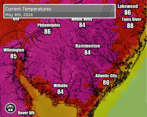
Another hot one today. But the good news is tomorrow's high is expected to dip back down to a comfortable 70 degrees.
0 notes
Text
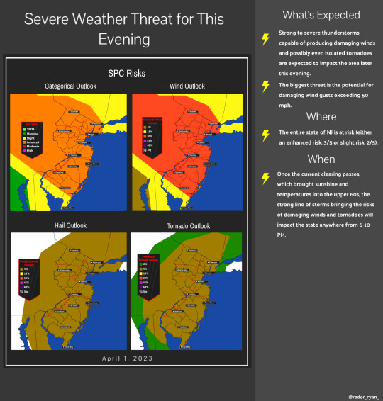
The cold front moving across PA will move through our region through this evening. Showers and thunderstorms are currently moving in from the SW. Far southern portions of the state are expected to see the greatest levels of instability and shear. Severe thunderstorm watches in effect for these counties until 10:00 PM. Locally damaging winds pose the greatest threat, followed by hail ⚡️
8 notes
·
View notes
Text
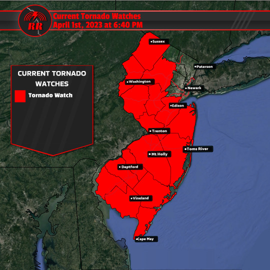
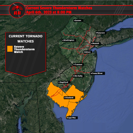
As we approach this evening, the severe weather that I spoke of yesterday will move in this evening. The squall line is currently moving into eastern PA and northern NJ. Since the last update, concerns have only grown. The potential for damaging winds has increased in many areas (15-30%) Concerning the tornado threat, the risk has only increased and expanded as many NJ counties are under a tornado watch (5%). This means that conditions are favorable for some of these severe storms to produce a brief tornado.
1 note
·
View note
Text
Details on what to expect and timing above ⬆️
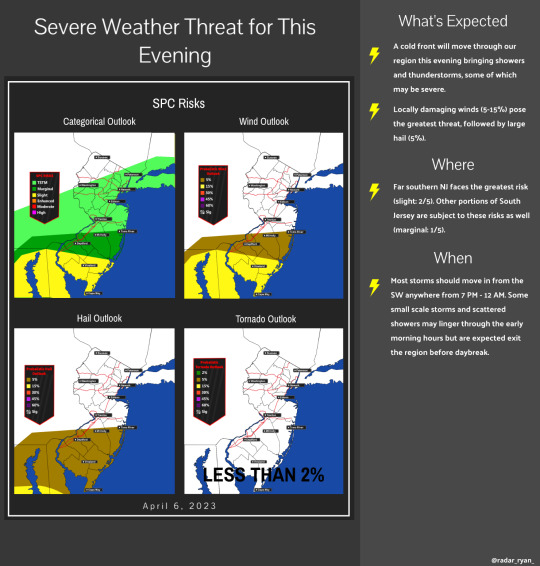
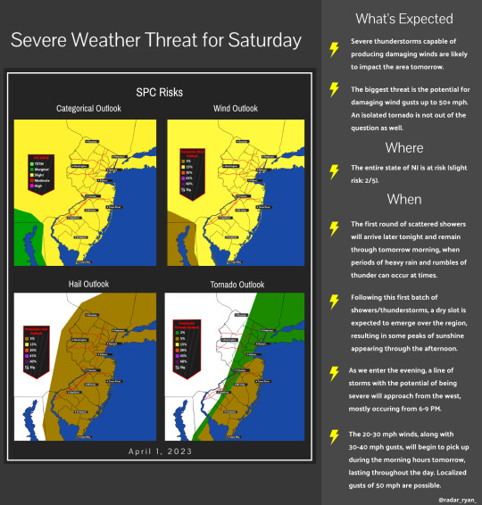
•Some severe weather can be expected tomorrow evening across the region. As of now, the entire state is highlighted under a slight risk (2/5) by the SPC, with high winds being the greatest threat. Even without the storms, gusty winds will present a risk throughout the day.
•Severe weather parameters appear to be favorable as convection takes place. The combination of strong shear, increased instability, and favorable lapse rates is expected to contribute to the development of severe thunderstorms throughout the region tomorrow evening. As of now, damaging winds remain the greatest threat as heavy downpours within the line of storms will interact with the strong low-level winds, resulting in a widespread line of intense winds as the front moves through.
•The risk for high winds is not the only threat however, as recent soundings also indicate a window of opportunity when wind profiles will advance ahead of the frontal boundary, suggesting that a supercell, or possibly a tornado, may develop in this time frame.
•Not only this, but a dry slot is expected to emerge, destabilizing the atmosphere as temperatures climb and moisture levels rise. There is a possibility that the severe weather could worsen if this sunshine persists for a long period of time.
1 note
·
View note
Text
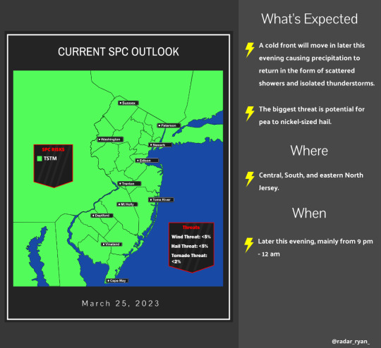
Looking like this evening may be a repeat of Thursday night as far as thunderstorms, proving once again that spring has arrived. This will occur once a cold front moves in later this evening causing precipitation to return in the form of scattered showers and possibly isolated thunderstorms. The biggest threat is the potential for pea-to-nickel-sized hail along with some breezy conditions with the line that is expected to move through.
1 note
·
View note
Text
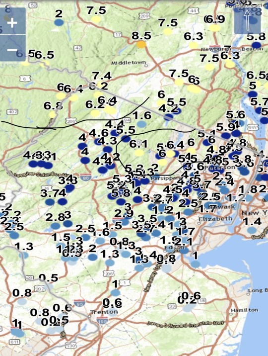
Snowfall forecast and measured snowfall comparison from our latest snowmaker. It appears that the 6-8" fell in swaths rather than covering most of the forecast area. All in all a decent forecast.
2 notes
·
View notes
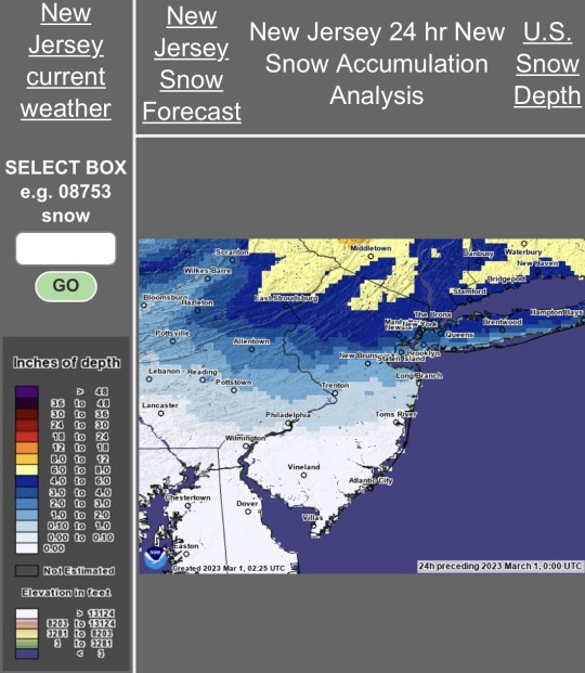
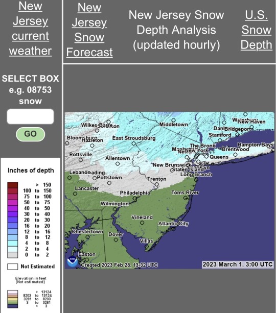
Text

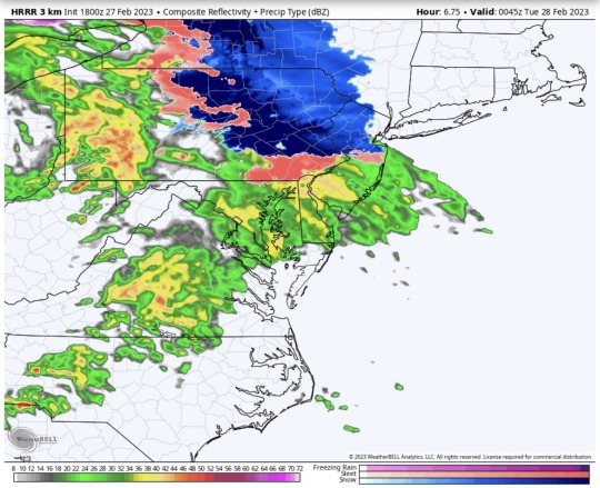
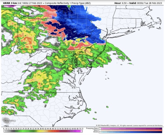
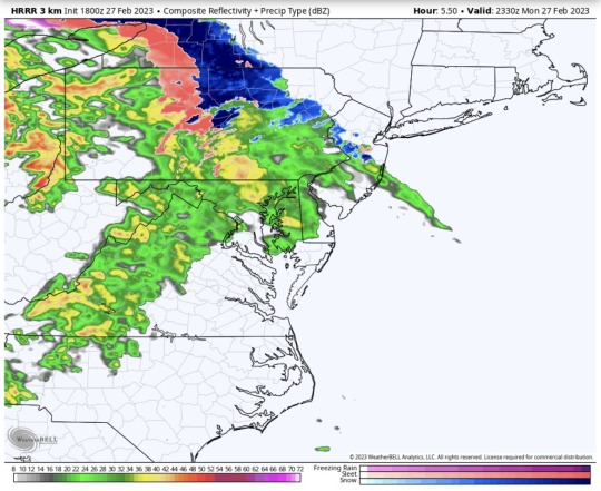
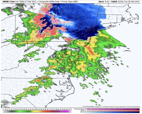
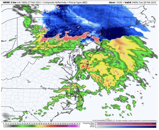
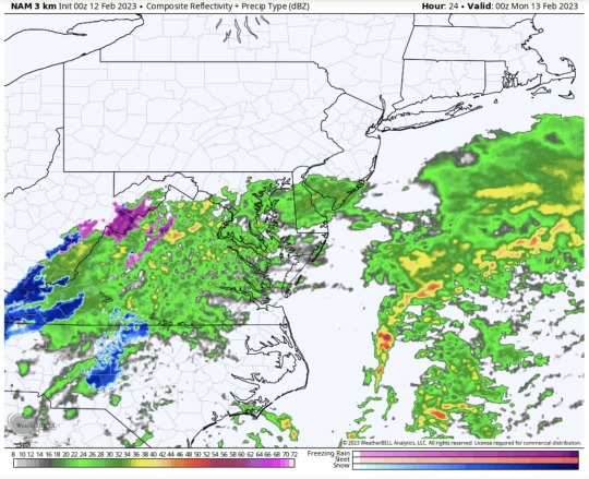
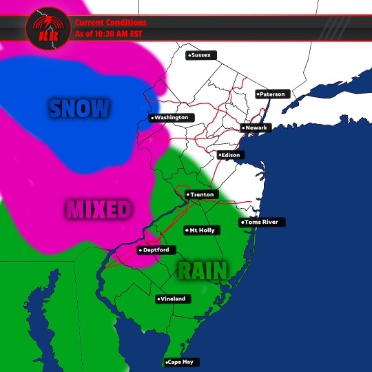
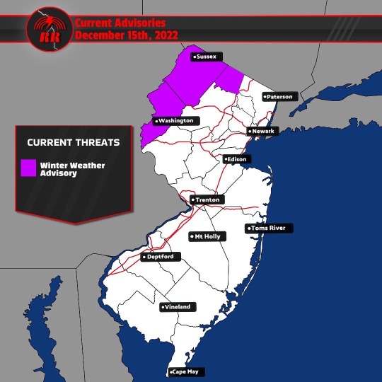
•A system bringing rain, sleet, and snow moves through this evening through tomorrow. Rain should move in this afternoon around 4-5 PM in South NJ. Moderate showers will stick around throughout the overnight hours as well as tomorrow morning. For the remainder of Tuesday morning, spotty showers likely to linger a little longer.
•As we head into the evening hours, by 6-7 PM, wintery precip will arrive for portions of central and north Jersey. The area of mixed precip will begin to spread through central Jersey as temps fall around 8-9 PM, hovering the I-195 corridor. If the freezing line manages to travel S enough at this time, light snow and sleet may be able to sneak into areas just south of Trenton. Little to no accumulation is expected here. Throughout the overnight hours, the freezing line will lift N getting further into north NJ south of the I-78 corridor by the early morning hours Tuesday. This may cause periods of sleet and possibly freezing rain to occur S of I-78. The most uncertainty in the forecast is whether additional cooling from the north will be enough to push the line of mixed precip further south. Along I-95 from Trenton to Philadelphia, periods of sleet can be likely by the onset with initial cooling.
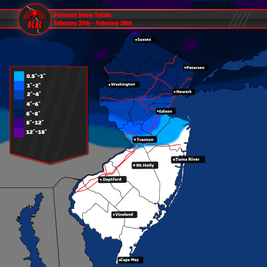
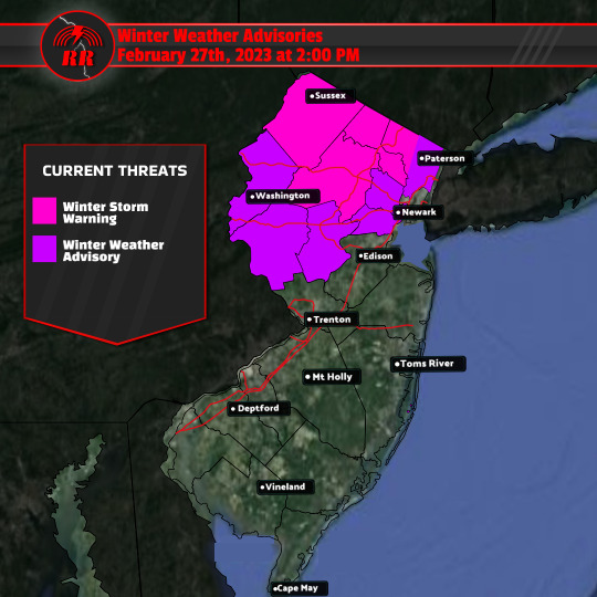
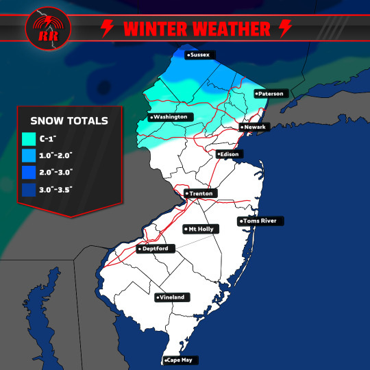
•Further north to the I-78 corridor, most dominant form of precip will be moderate to heavy snow. By daybreak Tues things will have settled down a bit, with a few snow showers possibly adding 1-2". As far as totals, It’s tricky to forecast exact figures since models are having trouble reaching a consensus. It’s more likely that regions north of I-78 will see totals in the 3-6" range. As you move closer to I-80, especially further north, I expect totals to be more like 6-8". It is possible that pockets where snow will be heavier can generate an inch or two more than this, but doesn’t seem to be likely for the majority of the forecast area. Winter storm warnings are currently in place for Passaic, Morris, Sussex, and western Bergen counties.
•It is across the I-80 corridor (mostly NW), where the snow will be heavy at times tonight with hourly snowfall rates of an inch possible. By Tues afternoon, most precip is on its way out, improving S to N.
1 note
·
View note
Text
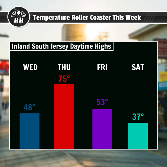
•Today it’s chilly, rainy, and in the 40s. This will not last for long, as big changes in temperature this week as a warm front pushes through the region bringing temperatures into the mid to possibly the upper 70s on Thursday, the warmest it has been since November.
.
•Because of the uncertain northern reach of the warm front, the main story for Thursday is the widening temperature divide between north and south. The warm air will likely struggle to travel northward past higher elevations across northeast PA and northwest NJ.
•As the exiting low begins to deepen offshore, the warm front could drift southward across parts of north and NE NJ in the form of a backdoor cold front. This presents a rather challenging forecast since the temperature gradient will be very steep and will depend on the positioning of the frontal boundary. North of the front, there will most likely be more clouds and a few passing showers, with highs only reaching the mid-50s. Further south towards south Jersey and the Delmarva, expect more sunshine and widespread temps in the 70s.
•Thursday evening, the slow-moving backdoor front will try to move SW towards the northern NJ/PA border and cover much of coastal NJ before the stronger cold front moves in from the west and pushes eastward through the region. This is the front that will result in temps dropping overnight throughout Friday. A warm sector may pass over South Jersey as the cold front shifts westward, causing highs in the upper 50s to occur early on Friday before daybreak. By Friday afternoon temps would have fallen into the mid 40s.
•These falling temperatures will also be accompanied by very strong northwesterly winds associated with the pressure gradient behind the front. Expect winds 20 to 30 mph gusting at least 30 to 40 mph.
•Cold high pressure will begin to shift offshore Saturday, bringing in a low along a fronts boundary. This will drop temps even further to the low 20s Friday night into Saturday morning. The high on Saturday will likely be in the upper 30s for South Jersey and lower 30s for North Jersey. This means we will have gone from well above average temps on Thursday to well below average temps on Saturday.
1 note
·
View note
Text
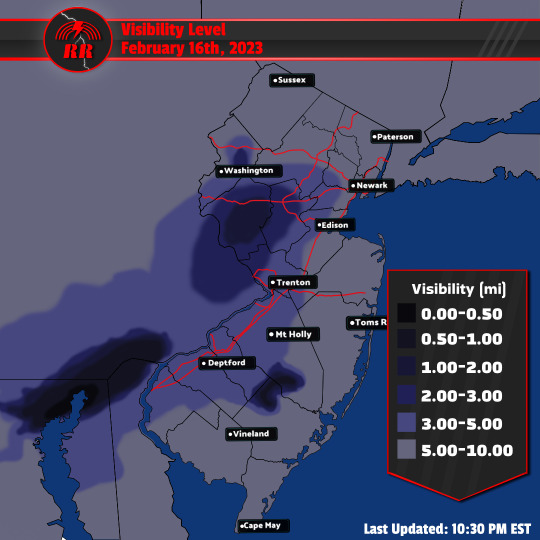
Some foggy conditions have been observed throughout the region tonight. A few reports of visibility below a mile, some as low as a quarter mile, indicate locally dense fog has developed. It is expected that the fog will gradually clear over the coming hours.
1 note
·
View note
Text
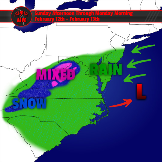
•The warm sunny weather we have had so far this weekend will come to a halt tomorrow, when an upper-level low will track off the mid-Atlantic coast. Temps will be noticeably cooler than they have been recently as this system pulls in colder air from the northeast.
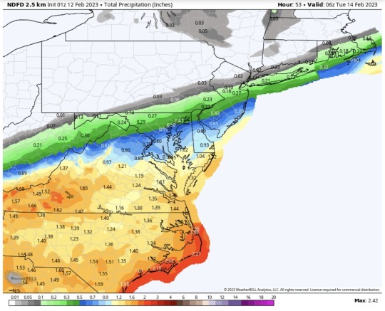
•This system will bring quite the rain event to portions of SSE NJ throughout the evening tomorrow as it taps into plenty of moisture. Further west towards I-95, will see significantly lower rain totals as there is more drier air in place. Expect the nor’easter to bring rain totals as low as a quarter of an inch towards this area, and closer to reaching an inch further south and towards the shore. Expect the majority of the rain to push into the area late Sunday afternoon into the early evening hours. The rain will continue throughout the night and can be moderate to heavy at times, tapering off by early Monday morning.
•This is not the only thing we have to watch out for tomorrow, as there will be a strong pressure gradient that will develop toward tomorrow night, resulting in the formation of gusty northeasterly winds, especially towards the coast. The winds will diminish Monday morning as well. These winds will be pushing onshore, which of course brings the threat of coastal flooding. may still result in some localized limited coastal flooding tomorrow night.
•By Monday, the mild temperatures return! South Jersey will shoot back into the mid-50s, with North Jersey following behind with highs in the lower 50s.
1 note
·
View note
Text

Merry Christmas everyone! Hope you’re all having a wonderful holiday season. Here’s the latest 5-hour afternoon and evening forecast for inland South Jersey. Overall, looks like we are going to have favorable travel conditions this Christmas. However, it's still important to watch out for patches of black ice.
We were certainly off to a chilly start this morning, with temperatures mostly in the teens through 7 AM. Since then, temps have been rising into the mid 20s. Temperatures now begin to fall into the lower 20s as we head into the late afternoon and early evening hours.
As we get closer to 8-9:00 PM, we work our way back into the teens. Mostly clear skies are in the forecast overnight, with some possible upper level clouds passing through from our west. Winds will be relatively calm, but have the ability to bring bitter cold with it, as it once again brings wind chills in the single digits.
1 note
·
View note
Text
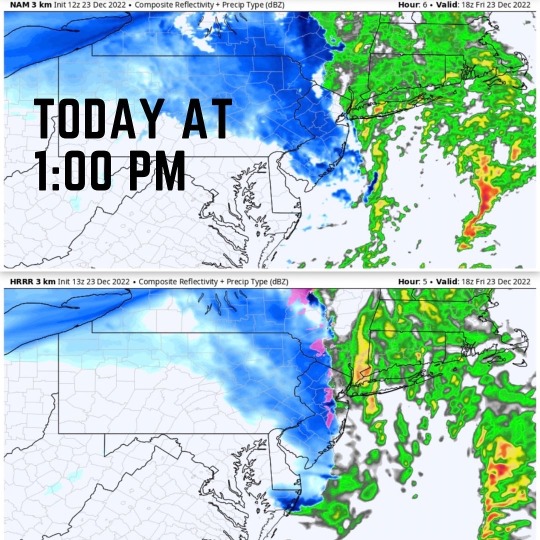
As the back end of the storm moves through by the early afternoon hours,likely 1 or 2 PM, we may be able to get some brief snow showers move through. This includes most of the state, as this band of snow can extend into Southern Jersey. This will happen as colder air arrives, bringing temps to below freezing. Little to no accumulation is expected. A coating of snow is possible, which is more likely in northwestern New Jersey. Winter weather advisories have been issued for all counties excluding Passaic, Bergen, Hudson, Essex, and Union.
0 notes
Text
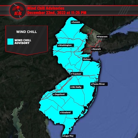
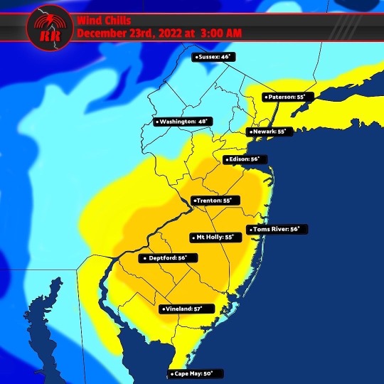
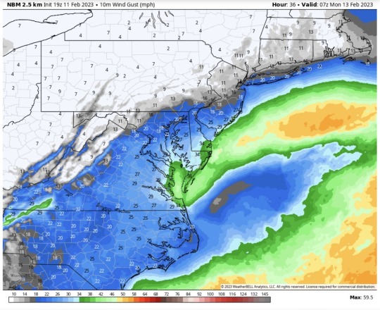
The system that has been giving us rain for most of the day will continue to stick around tomorrow. Tomorrow is the day the significantly strong cold front will push through the region, bringing high winds, coastal flooding concerns, and plummeting temperatures. A wind chill advisory now includes most counties in the state, save for a few in NE NJ. These counties are not exempt from the wind advisories however, as high wind gusts up to 40-50mph are able to impact the entire state, mostly along the shore, likely causing power outages.
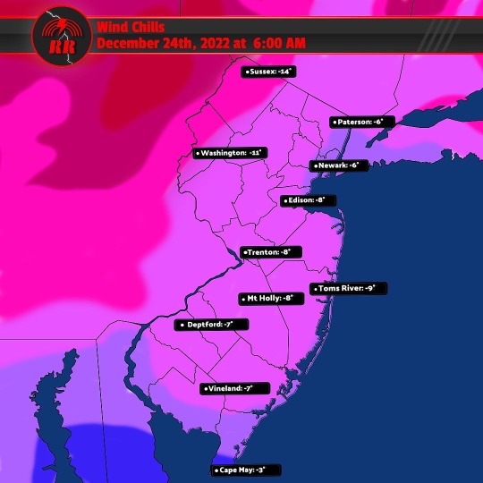
The rapid temperature drop could cause wet roads, bridges, and sidewalks to quickly turn to ice as a result of a flash freeze. Ice can begin to accumulate on surfaces as soon as late morning to early afternoon hours tomorrow. This will happen as temperatures will plunge from the mid to upper 50s all the way down into the 20s and 30s in just a few hours! As night falls, the high winds will continue to roar as temps lower into the teens and single digits. Meanwhile, wind chills are expected to drop into the negatives. The NWS includes coldest wind chills possibly reaching 10-15 degrees below zero between Fri night and Sat morning.
Friday morning and afternoon high tide cycles are likely to be impacted by the strong winds and result in possible widespread coastal flooding along the coast and Delaware River, with areas of major flooding along Raritan Bay.
1 note
·
View note
Text
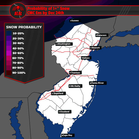
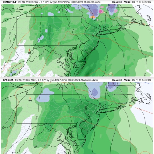
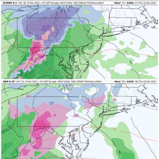
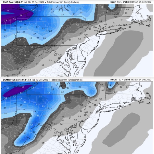

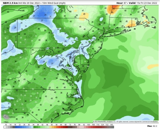
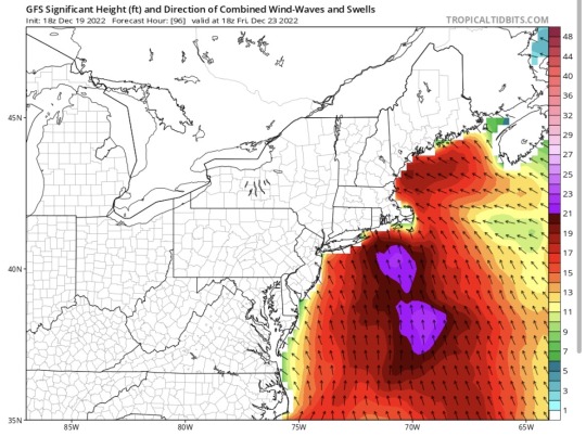
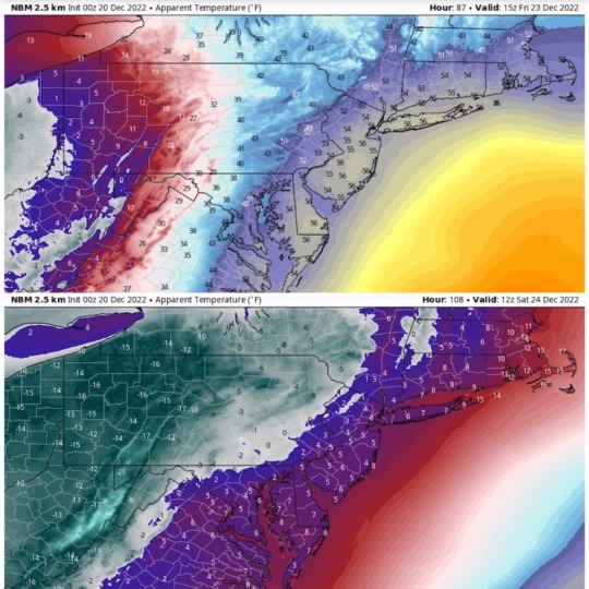
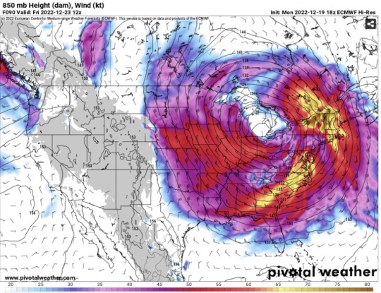
*Image on first slide is NOT a forecast. Just what we COULD expect IF we get snow later this week.* The biggest story at the moment appears to be Thursday and Friday, when a system is expected to impact the region, bringing strong low pressure just North of us in upstate NY.
This system can bring rounds of rain moving in by Thursday afternoon. If the precip moves in early enough when temps just right in North NJ, a brief snow shower or mixed precip may be possible. If this does occur it will quickly change over to rain as the morning progresses. This rain will be moderate to heavy at times. Total amounts expected between 0.5-1.5 inches, with the greatest rainfall in North NJ.
As far as snow, early Thursday morning at the onset of the storm, and late Friday night when the back end pushes through seem to be the best chances. It appears that northern Jersey could possibly see 1-2" of snow showers do occur. The latest CMC Ensemble seems to be the most likely scenario IF this becomes somewhat of a snow event. This is subject to change, as models do not completely agree.
There will also be a need to monitor coastal water levels as some degree of minor coastal flooding possible as a result of strong wind gusts on Friday. This seems to be the primary weather concern for the area, as a strong LLJ will build over the region by Thursday night, followed by strong southerly winds on Friday as the main area of low pressure passes.
This is not all, as the most dreaded portion of this system moved through, the Arctic airmass. With highs reaching into the mid to upper 50s on Friday, arctic air moves in from the West plummeting temps into the teens that night! Wind chills are likely to dip into the single digits as well. 🥶
1 note
·
View note
Text
Precipitation continues to progress further into the region as this coastal storm brings a mixture of wintry weather today before transitioning to rain for areas outside of the southern Poconos and northwest New Jersey by this afternoon. This mixed precip will be mostly brief since this is only the onset of the storm and temps are still closer to freezing. Most of the region will see little to no snow and ice accumulation. However, this doesn’t mean slippery conditions will be prevalent. Roads can easily freeze over, so it’s important to drive with caution! Most of the snow that will move into the region will be in NW NJ. The impacts of both ice and snow can very well lead to some significant impacts.
1 note
·
View note
Text
❄️ Sunday continues to look like the day we get some winter weather. Expect precipitation from this system to push eastward across Northeastern PA and Northern portions of the NJ as early as Sunday morning (likely between 8-10 AM EST), being predominantly snow. Rain should begin to spill into Southern NJ and the Delmarva by the afternoon hours.
Temps in this area will already be into the upper 30s and low 40s by the time the precip arrives. As far as the transition line from rain to snow still remains uncertain and can be tricky to forecast. Cities closer to I-78 can see temps closer to freezing. Areas along this corridor can see a period of wet snow possible before a change to rain occurs in the afternoon as temps rise. This means it’s possible that a freezing rain/sleet could even fall. Confidence remains low however. Any freezing rain will be limited and short-lived.
Closer to I-80 in North NJ, snow will last longer throughout the morning hours before possibly changing to rain in the afternoon. Despite this, the area is likely to see at least 1"-2" and possibly even 3"+ further North. South of this region, a coating to 0.5" is more likely.
Most of the rain and snow should exit the region later that evening heading into the overnight hours. Portions of far NE NJ can see some lighter snow stick around as temps drop as the sun sets ❄️
1 note
·
View note
Text
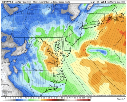
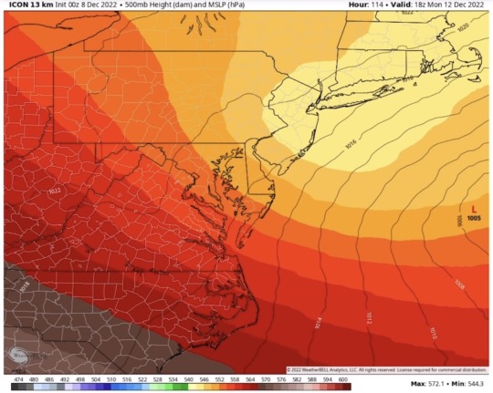
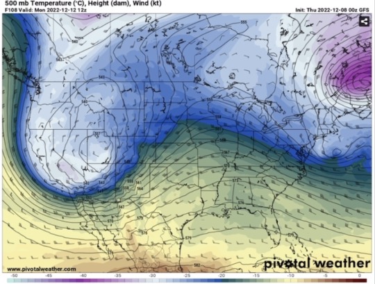
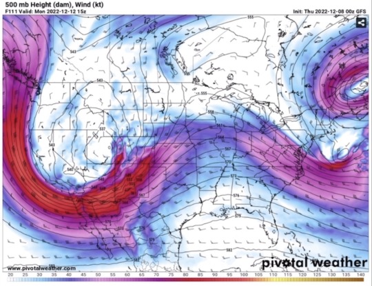
Guidance is not in total agreement, but there’s a trend that Sunday will be our unfavorable day. Models seem to be showing an upper low emerging from the Great Lakes and advancing SE very close to our region late Sun into Mon (Euro places it a bit further North than GFS).
In conjunction with this upper low, a surface low pressure system now seems more likely to give us widespread rain, and maybe even some snow across the state as some models project. This is really dependent on whether sufficient cold air can be pushed south as the system moves offshore by late Sun night into Mon morning.
Currently, the probabilities point to any snow being over North Jersey, possibly sneaking into Central portions of the state with some mixed precip to rain moving southward. Of course there's still plenty of uncertainty when it comes to snow in this system.
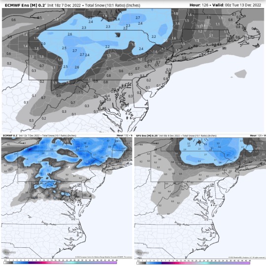
Most accurate representation of what we're currently looking at from Sun-Mon.
Mostly rain associated with this system for
NJ. North Jersey is more likely to see snow. Maybe a coating for central Jersey.
Amounts subject to change.
1 note
·
View note