
Last Seen Blogs

here-for-elriel-endgame
SJM give me Elriel

wizardcat
YOUR favorite virtual wizard idol

anominous-user
kinda crazy

marmoraort-blog
Margarita

silly-bean
Welcome to Beantown
Text
Cooperation of Mapbox and GeoThings for Humanitarian ICT
We are pleased to announce our partnership and cooperation with Mapbox, with the formal agreement done in October.
Mapbox is so devoted to humanitarian activity and is the leading company in location-based & space-based technologies with a huge hug to open source/data philosophy.
GeoThings is recently working with Asian Development Bank - ADB to deploy our ICT tools, 究平安 geoBingAn and geoMapTool, for the capacity building in various remote/rural area, where might seriously affected by natural disaster.
For the pre-/in-/post-disaster mapping, survey, and situation report, we see the needs of offline basemap while the data network is down. With Mapbox SDK for both Android and iOS development, it supports up to 4K tiles for offline basemap cache. This size of 4K-tile is about a Taipei city (FYI, for Jerusalem is about 2K, Boston is about 7.5K). It's a great feature indeed, however, for some of the remote/rural area that we focused, it's size usually greater than 4K-tile to be cached for offline.
With the partnership between Mapbox and GeoThings, we are not only be the advocator of Mapbox technologies, but also supported by Mapbox with the extension up to 10K offline tiles for offline. It will greatly benefit our OpenStreetMap community members and local government officers in Armenia, Bangladesh, Philippines, and Fiji to response to emergency situation. We are really looking forward to the cooperation and feeling so great to have a solid partner on the humanitarian way to benefit the world! Let's do it and make it impact, GeoThings <3 Mapbox!
0 notes
Text
Together with Taipei City Government in response to Typhoon
Typhoon Soudelor hit Taiwan in 2015, over 3000 cases of tree down were reported for Taipei city, but only half of them were resolved after 2 weeks. The amount of work loads to clean up those wiped-out-tree are massive. Even the Taipei City Government worked 24/7, the progress seems slow still. GeoThings was thinking about, it should be resolved together with community, and need to have some mechanism to feedback to the authority.
Last month, Typhoon Nepartak hit and caused quite a lot damage to eastern part of Taiwan. Since geoBingAn has already supported some local governments as situation report platform, now we further collaborate with Taipei city government for EOC (Emergency Operating Center) case update and Parking Information Notification before/during/after typhoon in response to Nepartak.
For the predictable natural disaster, such as typhoon, both central and local government will setup EOC so can response to any emergency in time. During the typhoon affected period, citizen usually call the local government to report the situation in order to get it fixed. Such as tree down, power outage, building damage, and so on. The geoBingAn from GeoThings is not just allowing the citizen to report with geo-tagged photo, but also can make it to be the update/supportive information to reported cases. Via geoBingAn, now the citizen can report what happened near by (geoBingAn Report feature), can know what happened near by (geoBingAn Near By feature), can even feedback what’s fixed near by (simply reply the reports in geoBingAn).
With those valuable information that feedback from citizen, local government doesn’t need to deal with the issue that might be already fixed/handled by community, situation is more up-to-date for both citizen and government agency. The most important thing is, community can really be a part of the response process after disaster. This capacity should be built not just for Taipei, not only for Taiwan, but should be built for all other disaster prone areas.
GeoThings spent the whole night with EOC staff, we now know much better about the work flow of emergency report and its process. Thanks to Department of Information Technology of Taipei City Government for the APIs that connects geoBingAn and EOC system. Also thanks to the hard-working GeoThings team for the quick response to the API integration in a very short time!
0 notes
Text
0206地震之後
經過這次地震, 我們感受到災害的無情, 也看到台灣的美好. 而防災救災可以研究與討論的議題真的相當廣, 甚至可以說是錯綜複雜. 或許我們就先從「救災組織的協調」,「物資需求協調」, 以及「志工協調」這三個面向來談談 資訊技術 對於救災的現況與未來展望.
救災組織協調
張教授在「國際救援,是否接受?」提到 “跨國團隊的溝通協調” 這個議題, 正是究心一直以來希望可以應用資通訊工具來協助的一個重要環節. 跨縣市的消防救難單位或許講著共同的語言 (或者說 protocol), 但加上民間救難單位, 甚至國際救難組織的參與. 如何把各個組織的人力能量 (包括技能與裝備) 以及任務負載狀況彙整給指揮單位了解, 也同時能讓指揮官的命令, 指派, 以及交辦任務完成狀態可以一目了然 (身於第一線的陳先生在 1050206支援台南地震維冠大樓倒塌搶救 說明了指揮系統的重要). 簡單來說, Who-is-doing-What-Where-When 這 4W 就是第一步最基本該彙整呈現的 (可以參考 UN OCHA 的 Nepal - 4W Resources) . 但這多少都牽涉到每個組織的習慣作法, 也考驗著資訊工具是否順手好用, 以及透過資訊平台所呈現的方式. 因此免不了要一個資訊團隊持續投入人力資源, 與救災組織夥伴們一起合作改進資訊工具.
而救災行動環環相扣, 筆者既然身為資訊宅, 關心且在意的部分也比較偏向防救災的 Information Management 環節. 這環節理論上較難單獨使用 Line 群組或是臉書社團來完成. 也因此, 或許可以跟著 UN OCHA 學習跨國際組織協調所遇到的難處, 或是參與 OSM Humanitarian Team (HOT) 來看基礎圖資應用於防災的能量建立, 也可以透過國際/區域銀行 (如 世界銀行 以及 亞洲開發銀行) 的力量了解各地政府如何建立防救災溝通管道. 這些看似零散的環節, 都會是發生重大災害時, 如何適時適當的運用資訊工具, 讓當地政府單位快速接入民間/國際救災組織的切入點.
回到台灣, 建立救災即時訊息發布的資訊接口 與 協作翻譯機制, 就可以是納入本地/跨國救援能量的第一步. 而國內救災組織的協調起點, 或許就可以先從即時彙整各個組織 (包括民間組織) 的 4W 資訊做起. 因為做好這看似簡單的一步, 就可以讓台灣做得比世界上絕大部分的國家都要好了.
物資需求協調
從批踢踢EarthQuake26板的「民間物資募集流向報告」來看, 政府的行動與民間的想法有著不小的落差. 既然地方政府對於救災責無旁貸, 那怎樣提供更好的工具來協助政府把這些事情做得更符合大家的期待呢? 在物資協調方面要做的事情很多, 我們先從 政府如何統計需求 以及 需求如何快速媒合 這兩點來看.
一��來說, 政府統計需求的方式大多會是透過在地的鄉里社區聯繫架構來往上反應. 國外如此, 台灣也如此. 而在發生災害的當下, 除了運用在地原本備災應急的物資, 若有不足, 則會反映給地方政府 (在台灣是由各地社會局協調). 因此建立可以迅速反應需求與狀況的資訊平台, 是很多國家都在進行, 也都會宣稱已經有建置的基礎建設.
目前台灣有消防署的 防救災雲端計畫 以及衛福部的 重大災害民生物資與志工人力整合網絡平台 的資訊系統, 希望把資訊從地方基層即時串接到中央, 從宏觀整合的角度去反應並調動, 以因應災情. 但在救災壓力與時間緊迫的情形下, “有工具”跟”有好用的工具”就會有很大的差別. 畢竟政府是救災行動的主導者, 若希望加強這些已存在的平台使用率, 不一定只能用威脅利誘 (法令規範或是經費補助) 的方法, 畢竟多如牛毛的查核項目會累死基層, 緊急的時候也不一定真的能派上用場. 轉個方向思考如何從「行動應用」的使用者經驗來讓上述的平台更加即時好用, 並且讓這個平台可以像我們常見的網路服務那樣持續根據使用者回饋而改善. 讓地方政府與社區基層做更有效率的回報並完成任務, 中央所需的綜觀資訊也就自然匯聚而成.
當然, 要用「服務營運」的執行方式, 在政府標案的架構限制下確實有所困難. 但換個方式想, 其實政府單位可以試著與救災資訊專業團隊合作, 結合有心的民間組織以及社群力量, 相信能事半功倍, 更見成效.
至於「需求快速媒合」這點, 可以從 組織對組織 的需求媒合先談起. 因為從協調者來看, 打一通電話可以搞定 5000 件毛毯的需求缺口, 在時間與人力的成本就會比設立表單讓大家捐毛毯的方式來的快, 對於衍生運送成本與管理人力也較低. 因此需要大量物資的當下, 怎樣讓政府快速得把需求資訊傳遞給有能力快速滿足需求的協調窗口, 就是重點.
在台灣由賑災基金會所協調成立的災害防救聯繫會報平台, 就是希望可以有效協調民間力量, 來協助政府救災. 目前已經有 50 個與防救災相關的 NGO 夥伴, 透過究心所開發的資訊平台來即時獲得政府最新的需求資訊, 並且回應可支援數目. 但政府的需求資訊如何主動即時並有系統的接入這個資訊平台, 而不是透過民間組織的詢問來觸發物資協調行動. 這除了靠資訊團隊持續與中央與地方專責窗口溝通並建立機制, 並且導入平常的防災演練教材, 才能真正在災時發揮效果.
當然除了像是簽訂開口契約這類組織/企業層級的協調, 還有物流, 盤點, 分配, 發放 等等與物資協調相關的工作. 其實每個環節都會有專業的團隊願意貢獻, 而資訊團隊則是要在這一項一項的環節去參與並觀察, 才能真正了解協調工作會遇到的困擾, 以及構思資訊工具所能改善的程度. 因此持續讓這些專業的團隊平時能演練並回饋, 緊急的時候就能根據專業來即時反應並採取行動. 這樣, 或許能把這盤根錯節的問題慢慢釐清, 讓大家不會覺得政府反應慢, 而在政府部門的夥伴卻又是累到趴.
志工協調
雖然去年八仙塵爆所需要的多為醫療專業志工, 我們觀察到一般志工較難在嚴謹的醫療體系幫上忙. 但早從八八風災開始, 發生災害事件時民眾透過網路揪團的義舉也不會少. 大家應用自己熟悉的資訊工具與平台來聯繫, 並進一步做有系統的工作分派與排班協調. 這次0206地震, 我們從「助台南志工團」的成立與執行成效來看, 有組織的民間志工與政府的救災系統整合並發揮了效果, 這也發揮了 以在地協助在地 的精神. 即時以及快速反應就是民間志工團體的寫照.
其實台灣不管是政府或是民間的志工平台不少, 不過政府與民間組織 (包括非營利組織) 的志工募集方式, 仍傾向以事先已登記之志工優先. 其最主要的因素還是信任與合作默契. 但是不應該每次發生緊急事件都這樣從頭來一次. 因此, 如何聯繫各個已經在營運的志工平台, 規格化資訊接口 (可參考 UN OCHA: Humanitarian ID 對志工資料的描述建議), 並且讓有願意協助且有能力協助的志工夥伴可以即時收到需求通知, 在對的時間與地點貢獻己力, 相信這就會更能增加我們面對緊急事件的能量.
而講到志工協調, 也要提這幾年在重大災害時出現的資訊志工. 目前零時政府 (G0V) 以及開放街圖 (OpenStreetMap) 都是活躍的資訊志工社群. 我們從 2016.02.06 台南大地震災情整合平台 來看, 就可以理解資訊志工的反應速度與協作能量有多快. 如何把我們提到三個面向所需要的資訊, 與資訊志工快速反應的能量做結合, 同時系統化且摘要化的呈現給救災團隊與指揮系統, 這可以是資訊彙整平台的下一個課題 (或說 坑).
另外在海地震災, 海燕颱風, 對抗伊波拉病毒, 到尼泊爾震災等國際救災行動, 人道開放街圖小組 (HOT) 應用衛星空照圖, 為原本沒有地圖的地區建立救災所需的圖資資訊, 也讓 紅十字會 (Red Cross) 以及 醫生無國界 (MSF) 等人道救援組織可以在當地順利進行協助. 甚至也有開始有政府單位以及區域銀行針對開放街圖的社群與開放協作特性, 來建立開發中地區的防災能量. 這在過去是難以想像的, 但也透過網路以及資訊科技, 讓遠在其他國家的資訊志工得以貢獻一己之力.
小結
0206地震之後, 我們看到傷痛, 我們也看到希望. 在面對災害的同時, 我們也看到政府單位與民間組織可以互補的可能. 藉由這篇看似落落長, 但實際可能只有碰觸到防救災生態皮毛的想法, 我們試著說明資訊科技與工具可能的角色, 而這也是究心公益科技持續努力的方向與目標.
0 notes
Text
關於在 OSM 註明防災地圖地區聯絡人的個資疑慮
以下完整呈現究心 slayer 與 Open Foundry 誠夏 的對話, 幸好我們都很正經地在討論 XD 若有建議或是問題, 歡迎到究心的粉絲頁留言給我們唷!
slayer:
大大, 抱歉打擾一下, 有個問題想請教您
就是以這個村里在地的防災地圖當成例子來看 http://www2.qxes.tc.edu.tw/drug/99.pdf
上面有緊急聯絡人, 也就是里長的姓名與電話. 因此在想說, 如果我們把這些資料都用人工收進 OSM 裡面 (當成避難處所的聯絡資訊), 會不會有使用權或是個人資料隱私權的問題呢?
Lucien, 2015年11月11日 12:07
Hi Slayer,OSM的資料層級架構,本來就有緊急聯絡人的處置嗎?
好,那是這樣,依照個資法的基本原則(第六條第一項第三款、第九條第二項第二款、第十九條第一項第三款),已公開的個人資料(當事人自行公開或其他已合法公開之個人資料)是可以不經書面同意就蒐集、處理、利用的,那何謂已公開的個人資料,說明在個資法施行細則的第13條(http://law.moj.gov.tw/LawClass/LawSingle.aspx?Pcode=I0050022&FLNO=13)。
簡單來說,緊急聯絡人,也就是里長的姓名與電話是可以不用他們再次書面同意就可以蒐集、處理,和利用的,不過!這些都還是個人資料,也就是說,還是要依個資法第3條,賦予當事人「請求補充或更正、請求停止蒐集、處理或利用,或請求刪除之地位。」
我2014年這篇文章「網路資料耙梳的法律邊界與 CC0 的公益釋出」:http://lucien.cc/?p=5977,其後半部就是在解釋和處理這個問題,可以搜尋文章內容「實務上兼顧個資法相關規範與資料耙梳實作需求的操作綱要,可以大分為下列三點:」,再看那三個要點。
配合這篇文章,在當年的COSCUP,我也給了一個近似的題目,其簡報下載連結如下:
ODP格式:https://www.openfoundry.org/of/download_path/openlegal/Do_the_Open_Data_web_crawling_in_proper_way_within_the_principles_of_legal_boundaries/20140720data.odp
PDF格式:https://www.openfoundry.org/of/download_path/openlegal/Do_the_Open_Data_web_crawling_in_proper_way_within_the_principles_of_legal_boundaries/20140720data.pdf
重點在於簡報的第83頁!蒐集、處理、利用已公開的個人資料時,在隱私權頁面或其他相應的地方寫上右列資訊,原則上就已經依法作好處置了:「相關資料收集自公開資訊,並已妥善進行去識別化流程,倘若您對於任一筆資料的呈現有個人資料上的疑惑,歡迎透過右列回報連結,將意見回報給資料的管理者。(The related data is collected from information that has been disclosed in public, and has been de-identified in the process of collection as well. However, if you have any concern about Personal Information protection issues, please be kindly submitting that to the data manager via the report link shown here: http://fakelink.data-crawler.net)
不過重點是,真的有當事人(個人資料的歸屬人)抗議要修改或要刪除他的個人資料時,已放到OSM裡的刪得掉嗎?或是能不能透過簡易的機制做到更正或刪除,會不會太麻煩,這是我一開頭就問「OSM的資料層級架構,本來就有緊急聯絡人的處置嗎?」的原因。
如果有的話,那我覺得這事不複雜,如果沒有,也許透過一個資料外掛的方式導進去,到時候會比較好處理?
slayer:
我們想把 OSM 的 contact 應用在 emergency:contact:phone emergency:contact:website 這樣
OSM 是有這樣的定義的, 要移除也不是難事, 就刪除這個 tag 就好
Lucien:
那就問題不大,能找到地方對這份資料寫一個簡要的聲明就沒問題了。
slayer:
現在在規劃的就是, 原本是小學, 緊急的時候變成避難處所, 這時候這個地點的功用與聯絡人與聯絡方式就會不同
所以平常會是: amenity=school 緊急的時候就是 emergency:amenity=social_facility emergency:socail_facilty=shelter emergency:contact:name=村長 emergency:contact:phone=27665252
這樣
Lucien:
了解
會轉過去
我覺得問題不大,或者這樣解釋,OSM整個資料庫上所有資料,都是可以自後自行更正的。
緊急聯絡人本來就會換人,要更正的時候當事人有更正途徑,解釋上本來就符合個資法的期待。
所以我的回覆是,依法沒有太大的問題,有人質疑時告訴他們個資法第6、第9、第19條併施行細則第13條,是可以做這樣的彈性處理的。
而如果當事人主張個資法第3條對個人資料的更正、補充,或刪除的地位,OSM本來就是一個大家可以協力更正、補充,或刪除過時資訊的平台,故也沒有問題。
slayer:
好耶,太帥了,謝謝大大!
0 notes
Link
After the efforts that contributed by OGC, ITU, and GeoThings staff, we finally make Open GeoSMS to be adopted by ITU and officially printed as ITU publication. We would like to introduce you, ITU Q.3615!
Really appreciated and thanks to you all who contributed to this specification, thank you!!
0 notes
Link
GeoThings is honored to be invited for “Urban and Climate Resilience and Sustainability” session with GEO (Group on Earth Observation), ITU (International Telecommunication Union), OGC (Open Geospatial Consortium), and the academic experts from Italy, Spain, and Austria.
Last week, GeoThings participated in the national strategy and framework discussion with VP of the highest administrative office in Taiwan. We addressed that not only to prepare and practice the disaster reduction/response/relief in Taiwan, but also to contribute our experiences for other regions that might in need. Taiwan and the south-east Asia suffered from lots of natural disasters,
That the major reason why we are more than happy to be a part of this event in Geospatial World Forum 2015, especially in “Urban and Climate Resilience and Sustainability” session. With the topic “Open Standards, VGI, and ICT for Resilience and Sustainability Building”, we are going to talk about how we leveraged Open GeoSMS (OGC Open GeoSMS and ITU Q.3615), Open Street Map, and mobile applications for the capacity building. See you in Lisbon!
0 notes
Video
GeoThings was on TV (USTV business channel)! We appreciated and thanks for all your supports!
We want to make it easy, with a lot of efforts that you didn’t even notice :-)
1 note
·
View note
Note
冒昧請問可以邀請究心的專員(工程師 講師) 蒞臨大專院校演講嗎?有關LBS發展與應用之分享 謝謝
應該是張教授吧? 我們持續聯絡並討論囉!
slayer@GeoThings
0 notes
Text
Noodle Map for ICCMNYC
Noodle map square
Team members: Slayer Kuo-Yu Chuang, Heather Leson, Francesco
Ciriaci, Fahed Alhaj Mohamed, Stephen Mather
On Saturday afternoon, Union Square, 5 crisismappers conducted a participatory mapping project to capture stories about the potentially affected community. Who are these humans of New York? What are their roles and activities in this beautiful space? We determined our best mapping tool and data collection tool to be our phones, specifically the Geo Things app. Our adventure started with a preliminary site walk through to quietly observe with no data collection. This time was used to provide full context into our plan. All our efforts to stay together was thwarted by a busy crowd. Distracted by a hovering helicopter the team got separated. We realized that we did not create a team emergency contact plan and almost had to default to twitter as a communications channel.
Once we reconnected, it was time for a lunch planning session over noodles.
Vignette 0.5: Noodles
We discussed out observations and decided that we were fascinated by the patterns of movement and the striking presence and character of the occupants of the space. Our plan cemented as a story all about flow points and intersections. The title became NOODLE Map.
https://www.youtube.com/watch?v=RK5v7-m_Ssc
Stephen created a physical map. We had large goals to also take a time lapse of the whole area but the Mapillary tool GPS was failing. So, we reverted to photos and vignettes.
Vignette 1: Plated with Dee
Vignette 1: Plated with Dee Dee has worked for 3 months at Plated, an online company that delivered uncooked meals to homes with all the supplies.

flickr
Vignette 2: Consumption Occasion
They offered us the red or blue pill, er, red or blue Red Bull to sample. Two marketing students were handing out free samples from the Red Bull backpacks. We needed the caffeine after a heavy lunch.
Awake we moved into the heart of the square

flickr
Vignette 3: Free Union Square Tour
Twenty people standing in a semi-circle is bound to catch your eye. Very quickly their moment of learning became ours as we became acquainted with the history of Union Square circa 18th century.
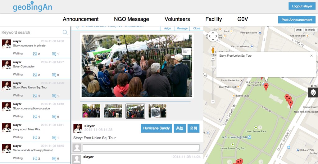
flickr
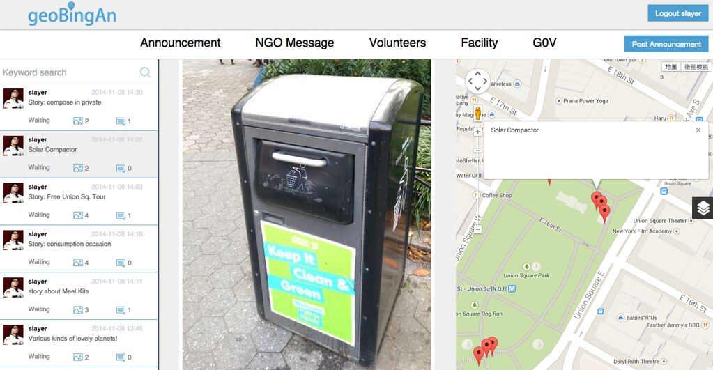
Vignette 4: the solar bin
En route to our next stop we spent some time discovering the Big Belly Compactor.
flickr
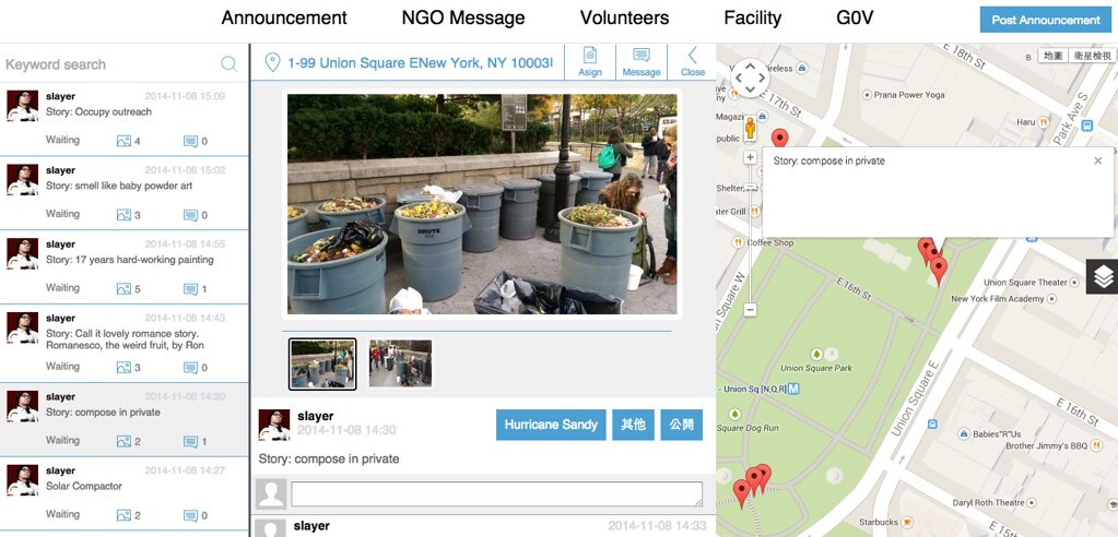
Vignette 5: Composting in Private
She quietly asked us to not take a picture of her working with the compost bins. Every Monday, Wednesday, Friday and Saturday she collects items for compost and sells bags of fully composted soil.
flickr
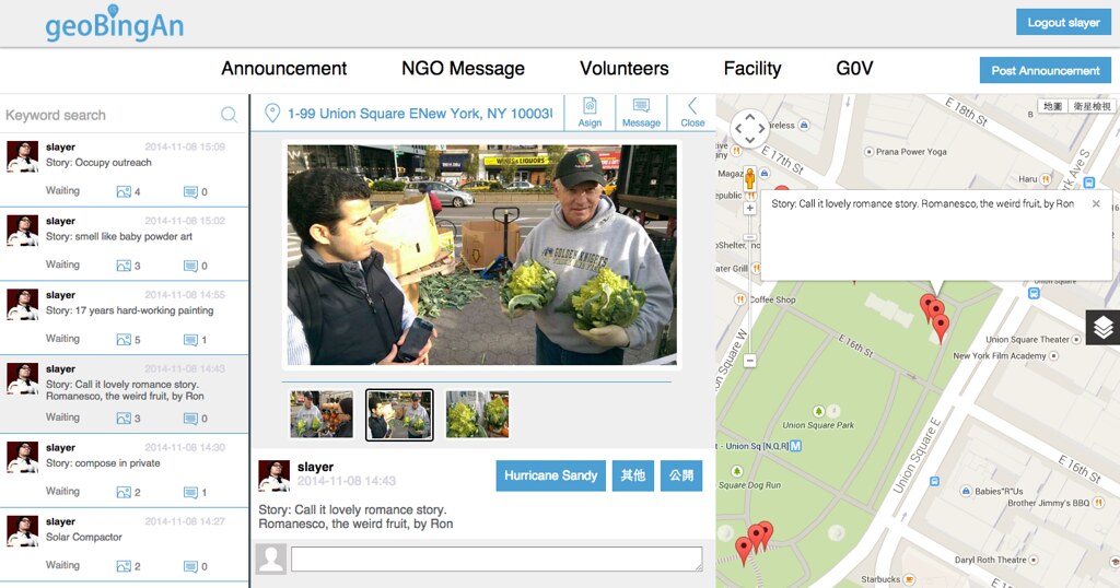
Vignette 6: A Cauliflower Romance Story
"I hate cauliflowers. Why would anyone eat something so awful." Said Ron, who surprisingly sells romanceso cauliflowers despite his distain.
flickr
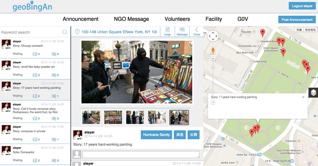
Vignette 7: Painting by Numbers.
The artist has been painting for 17 years and now sells his art I. Union square. Bundled up, he was ready for January, not an early November day.
flickr
Vignette 8: Smells like Baby Powder Art
It started with one girl in a black plastic bag. She poured baby powder all over head. As photographers swarmed, others began pouring baby powder over themselves. The air swirled with powder everywhere.

flickr
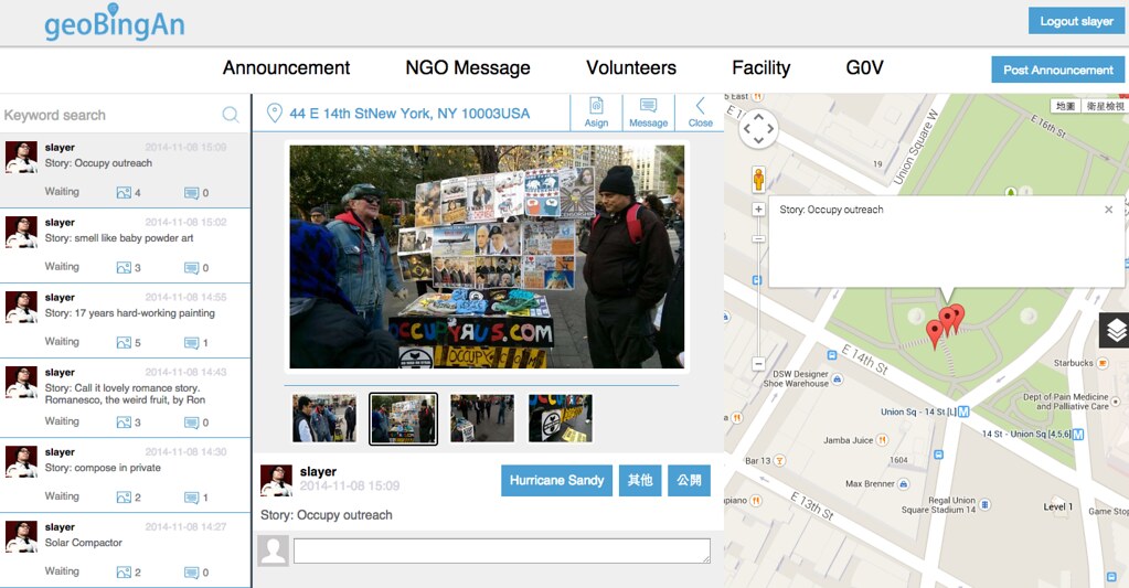
Vignette 9: Occupy Outreach
Our last stop after food, caffeine, a tour as well as a compost, art and cauliflower education was some political braining. The champion corner is a reminder of the much larger occupy community that met here a few years ago.
flickr
To sum, Union Square is a vibrant community of various activities, patterns and random flow. With so many people, cross-streets and Intersections /activities of life any incident would be very chaotic, but the community is super friendly and has a natural feel of partnership and solidarity despite their varying park life uses.
0 notes
Text
自己的家園自己救 - 談衛星空照圖的另一個應用
談到衛星空照圖, 可能大家最常接觸到的會是衛星雲圖 (一般來說會是紅外線+可見光的拍攝組合). 而究心團隊透過與國家太空中心的合作, 應用福衛二號衛星的空照圖來提供大家另一種應用的可能.
透過衛星空照圖, 對於森林是否被過度開發, 對於大型的河川污染, 對於海洋上漏油事件的追蹤, 甚至於對於失蹤飛機的找尋, 都可能透過群眾協作 (Crowdsourcing, 這裡比較不是群眾外包的意思, 而是讓大家可以貢獻自己的能力與時間, 共同完成某件事情) 的方式, 應用衛星空照圖來完成這些任務.
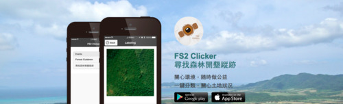
其實這個群眾協作的概念很簡單, 我們把很大範圍的衛星空照圖分成很多小塊, 而大家透過手機上的 APP, 就可以根據任務與介紹來協助標記這些小塊的圖示. 例如「尋找森林開墾蹤跡」這樣的任務, 就是希望能夠標示出有被開墾的山林地. 不管是合法開墾, 非法開墾, 土石流或坍方造成森林被砍伐. 而這個 FS2 Clicker 就是讓大家可以在手機上, 透過回答簡單的問題就能參與這個群眾協作 (Crowdsourcing) 的專案了!
FS2 Clicker 的 FS2 就是福爾摩沙衛星二號 (Formosat-2) 的簡稱, 而稱為 Clicker 的原因, 就是希望使用者簡單的按下「是」或「不是」這樣的問題, 就能協助完成群眾協作的案子. 以「尋找森林開墾蹤跡」這個案子來看, 使用者只需要回答「有沒有看到開墾痕跡」, 不論是天然或是人為, 合法或是非法, 都歸類到「有開墾」, 藉以檢視山林的開墾狀況.

同樣的想法, 我們可以延伸應用到「找出油輪漏油痕跡」「尋找飛機墜落蹤跡」「比較海岸線退化痕跡」等等應用專案. 而這些專案, 我們也希望可以邀請不同的環保組織, 公益組織, 甚至是開發者社群等. 讓平常和我們好像距離很遠的衛星空照圖, 應用在生活上息息相關的調查專案. 這個平台當然也會以開放資料的概念, 透過 API 提供調查結果, 也讓開發者或是研究人員可以做進一步的分析與統計.
你有沒有想到怎樣的問題, 或許可能可以透過大家的力量, 應用衛星空照圖得到答案的呢?
FS2 Clicker 介紹網頁
FS2 Clicker Android App
FS2 Clicker iOS App (審查中, 即將上架)
0 notes
Photo
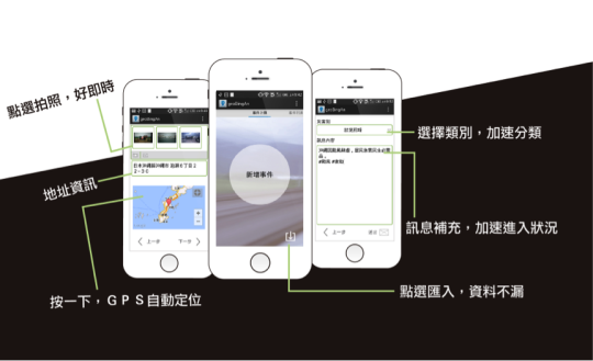
[寫在麥德姆颱風來臨之前]
我們都知道, 遇到關於人身安全的緊急狀況時, 要打 119 求救. 不過我們所在的環境可能因為災情的影響程度而有不同的需要. 可能我們的家園受到損害, 可能聯外道路因為山坡坍塌而受阻, 可能我們的社區需要物資補給, 可能我們平日參與的公益組織所照顧的民眾需要熱食供應. 一個一個不同的需求, 都可能在災害來臨的同時發生, 但這又不是 (也不應該) 每件事情都非得要勞煩 119 才能解決.
我們可以把狀況發佈在臉書, 靠朋友與鄉民的力量轉發. 但是這些訊息並沒有辦法直接且立即的讓有能力回應或是協助的救災組織與民間志工團體聽到. 我們的家在可愛的台灣, 有著很多有熱心而且願意幫助他人的民間組織以及公益組織. 但是過去救災以及需求資訊的可能還不夠即時, 讓願意幫忙的人找不到地方, 而需要幫忙的人不知道怎樣提出需求. 而在社群網路上的資訊, 往往也因為不斷的轉載與複製, 而失去了其時效與作用.
透過究平安這個工具, 我們可以即時的把需求傳遞給救災組織. 我們有賑災基金會, 有公路總局, 有法鼓山等官方與民間組織. 一起同步面對因為災害而產生的需求. 我們期望能更有效率的協調救災資訊, 也能避免資源重複投入的浪費.
同時我們延伸守望相助的概念, 應用究平安這套資通訊工具, 我們可以回報自己看到的災情狀況. 同時也讓在其他地區的救災組織與志工夥伴可以同時了解, 當地最新狀況為何, 可能需要怎樣的協助. 這些資訊, 都可以透過究平安彙整給不同單位與組織, 而間接形成救災的協調動力.
究平安, 就是希望讓大家真的能感覺到平安的一套工具. 因為這個工具的後面, 有著許許多多熱心助人的組織與志工. 那才是讓這套資訊工具有溫度的原因...
究平安資訊平台
究平安 Android 版本
究平安 iOS 版本
0 notes
Text
GeoThings Grand Opening - Official Press Release (in Traditional Chinese)
工研院首家社會企業新創事業 「究⼼公益科技」正式成立
工研院今(30)日宣布衍生新創事業「究心公益科技」正式成立!這是工研院第一家以社會企業為主所成立的公司,未來將以「ICT for Humanitarian」為宗旨開發資訊救災技術,並營運救災資訊協調平台,讓全球救災能更精準掌握資訊,有效準確分配救災資源與人力。目前這套系統已經持續與慈濟、紅十字會、法鼓山等救災組織合作使用,用工研院的科技讓愛心升級。
工研院院長徐爵民表示,工研院長久以來秉持著以科技研發,帶動產業發展,創造經濟價值,增進社會福祉為任務宗旨,並持續在��瞻科技研發及推動產業躍升等工作努力,至去年已促成多達89家的新創公司成立。不僅如此,工研院更不忘用科技結合社會公益,讓科技研發也可以在社會公益領域找到新的營運模式,藉由科技為人類帶來更美好的生活,為此,工研院第一家新創的社會企業-究心公益科技正式成立。
究心公益科技執行長莊國煜表示,工研院開發的「究平安」救災資訊協調平台是整合政府及民間救災組織的平台,可在混亂的資訊及各方救災力量中搭起橋樑。前線的救災人員只要安裝「究平安APP」,便能拍照記錄災情與回傳地理座標簡訊給操作「究平安Web」的指揮中心,指揮中心便能依據精準的地理標示及救災需求,在平台上有效分配救災人力與資源,提高救災效率。特別的是,這套平台採用不佔頻寬的地理座標簡訊格式,在訊號不佳或是跨國救援的災區依然可立即回傳災情,在沒有訊號的災區則可暫存紀錄,等到有網路訊號就能自動上傳回報,在國外也不用特別申請數據漫遊,讓救援力量發揮到最極致。
莊國煜進一步指出,究心科技獨門秘技就是公司所開發的地理位置簡訊Open GeoSMS規格,目前已成功躍升為國際標準組織的標準之一,救災人員可以在不同裝置或不同軟體之間,採用相同的「救災語言」相互溝通。如此一來,將可全面終結全球救災單位各個裝置及操作軟體平台不相通的瓶頸,未來對於全球大規模的救災行動執行,將會是如虎添翼。
究心公益科技營運長陳孟敏表示,究心的防災平台目前免費提供APP下載,營運前1~3年將藉由與多個國內外組織的合作專案,在不同國家場域試煉收取相關費用,預計3~5年後將應用核心產品平台轉型為客戶應用導向的全方位服務,持續透過專案計畫作為公司營收來源。
【新聞聯絡人】工研院行銷傳播處 呂美玲 0918515173 [email protected]
究心科技產品主要技術特點:
O 簡訊夾帶地理座標:明確標示待救援位置,縮短救援時間
O 災情紀錄與回報:可結合手機拍照回傳災區即時狀況
O 簡訊格式不佔頻寬:山區收訊不佳或人多網路擁塞的地方也可以傳訊
O 沒有網路也能使用:在沒有網路通訊的地方,地理簡訊資訊可先紀錄暫存,等到一有網路訊號,即可自動上傳回報
O 情報平台圖文呈現:災情回報的簡訊在情報中心以圖文配合地圖呈現,災情分佈一目了然
O 災情搜尋與指派:情報指揮平台可搜尋大量回傳的災情訊息,並透過座標簡訊進行指派
新聞辭典
究心公益科技介紹
究心公益科技是工研院支持與輔導下成立的第一個社會企業,「究心」之名取自GeoThings,代表著「希望服務能從技術出發,但一切終究是要回歸到本心及人性。」究心公益科技公司董事長為劉炯朗博士,公司團隊成員,不僅擁有專業的資通訊技術,也致力讓世界更美好,透過與非營利組織(NPO)合作,發展出多項NPO活動相關的技術產品,包括與台灣大哥大基金會合作的微樂志工平台,紅十字會的救災服務平台等等,從人力募集、需求資源到服務地點,所有訊息都一目了然,解決了傳統救災動員可能出現的訊息紊亂狀況。
GeoThings救災資訊協調平台
GeoThings救災資訊協調平台指的是,只要透過手機,傳遞一封簡訊,輕輕滑動手指,就能將你的手機化身為救災行動地圖,在GeoThings救災資訊協調平台上標示出到正確待救援位置,能列出災區需要飲水、食物、毛毯、燈具等物資地點,將可不用再浪費時間在地點溝通、物資運送調度及志工調配上,這些全部只要透過一封簡訊就能全數搞定。
延伸閱讀
維基百科-社會企業 http://zh.wikipedia.org/wiki/%E7%A4%BE%E6%9C%83%E4%BC%81%E6%A5%AD
社企流-台灣第一個華文社會企業資訊匯流平台
社會企業的定義 http://www.seinsights.asia/aboutse
0 notes
Video
youtube
Cherish the Power of Volunteers
Willo, the Micro Volunteers Platform, is one of the latest projects by GeoThings, collaborated with Taiwan Mobile Foundation. We provide a free ICT platform for NPOs in Taiwan and make it easier for them to post and organize the charity events, easier to reach target audience and call for volunteers, manage the participant list, and reduce the efforts of registration process.
With the high penetration rate of smart phone, mobile app is a must for people/volunteer to get information, especially for the young generation. It will cost much for NPO to build their own tool like this, but together with various NPOs, a portal platform will be useful. That makes Taiwan Mobile and GeoThings to build this platform, Willo.
The focus of GeoThings is the coordination of information for disaster response and management. Through Willo, we will stay connected with the volunteers and NPOs. When disaster strikes (we sincerely hope not), crowdsourcing, emergency response, and even disaster relief then can be applied on it.
We love this attached video and we believe humour can break the language barrier. Enjoy and have fun :-)
Willo Web Site: http://www.willo.tw/
Willo Android App: https://play.google.com/store/apps/details?id=com.taiwanmobile.volunteers
Willo iOS App: will be online soon
0 notes
Note
I work for an NGO in the UK and was trying to find out more information about GeoThings, how you work and company structure. For example are you a charity or commercial concern? Do you organisational structure information? Details or partnership projects with other NGO's charitable organisations. What countries you have worked in? How are you funded?
Hi,
We would more than happy to answer your questions. GeoThings is a public benefit company and works with NGOs, NPOs/Foundations, government agencies, and private sectors. You can take us as a IT service company, for profit, not only for the max profits for our investors but for the public benefit. You may reference the further description here on Wiki (http://en.wikipedia.org/wiki/Public-benefit_corporation).
Please feel free to send me an mail to "slayer [at] geothings [dot] tw", we can have further discussion on the questions that you mentioned :-)
slayer
0 notes
Photo
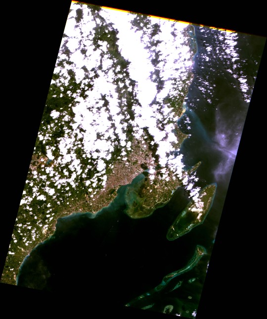
Our OSM TW partner, Dong Po, told us about, there are still lots of "red area" (means the satellite image need to be improved) in Philippines. Can we have some better image from NSPO for OSM?
After a quick discussion, NSPO helped to task satellite (Formosat-2) that will further provide image for OSM community to achieve a better mapping. Although we had only the cloudy image currently, we believe the better one will be delivered soon with WMS for OSM community. Thanks to our partners and also thanks to the amazing OSM community. You guys really make the ICT for Humanitarian!
0 notes
Photo

iHelp X GeoThings
This is an open source project to deliver ICT as tool for the people who is not that convenient to response emergency with their location. Maybe they can't hear, maybe they can't speak, Maybe they can't understand the local language to let others know the address. With some pre-set messages, user can quick report their current situation with location to the police force in Taiwan via SMS. Thanks to the GPS/AGPS feature on smart phone, we encode those retrieved location information with OGC Open GeoSMS standard, which enabled the receiver (emergency responder) can quickly know where to help.
Not just to report self-emergency, iHelp X GeoThings project will also enable people to report status during disaster. To response "Disability is not Inability", we support with this app for the International Day for Disaster Reduction 2013 by UNISDR.
For a better tomorrow, we code!
iHelp on GitHub
0 notes