
Last Seen Blogs

buidatseo-blog
Sans titre

lalafellmitosis
Pepepsi Pepsi

ciaochiloma
Adanma💕

mpochin6
Untitled

mewhenimsad
Mando Is Baby Gorl
Text
Satellite Image Processing and Satellite Image Distribution Service | CONTEC
CONTEC has been as a top satellite image processing and satellite image distribution service as a whole-ground integration solution provider in Korea.
Contec Satellite Image Pre-Processing Service
CONTEC's pre-processing of satellite images is applied to calibration algorithms to correct radiometric, geometric, and spatial distortions.
Pre-processing operations, sometimes referred to as image restoration and rectification, are intended to correct for sensor- and platform-specific radiometric and geometric distortions of data. Radiometric corrections may be necessary due to variations in scene illumination and viewing geometry, atmospheric conditions, and sensor noise and response. These se will vary depending on the specific sensor and platform used to acquire the data and the conditions during data acquisition. Additionally, it may be desirable to convert and/or calibrate the data to known (absolute) radiation or reflectance units to facilitate comparison between data.
Variations in illumination and viewing geometry between images (for optical sensors) can be corrected by modeling the geometric relationship and distance between the area of the Earth's surface imaged, the sun, and the sensor. This is often required in order to more readily compare images collected by different sensors at different dates or times, or to mosaic multiple images from a single sensor while maintaining uniform illumination conditions from scene to scene.
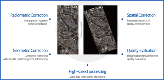
Features of Satellite Image Pre-Processing Service
Ø Radiometric Correction: Image pattern/system noise cancellation
Ø Spatial Correction: Image resolution and quality enhancement
Ø Geometric Correction: Geometric correction with satellite positioning/ orbit information.
Ø Quality Evaluation: Image radiometric/ geometric quality evaluation.
Ø High-speed processing: Mass data high-speed processing.
If you are looking for a satellite image pre-processing service, you can find them at Contec.
Click here to contact Contec.
View more: CONTEC Satellite Image Processing and Satellite Image Distribution Service
0 notes
Text
Easy-To-Use Ground Station Services for Satellite Operations | CONTEC
CONTEC, founded in January 2015 as a spin-off from KARI (Korea Aerospace Research Institute), provides space ground station services, satellite image processing and application services, and a whole ground integration solution. Contec currently has multiple teams of engineers divided into two different offices in Korea and Luxembourg as its subsidiary, with more than half of them having at least a Master's degree and the heads of these different teams having at least 10 years of experience in the space industry. They are attempting to provide meaningful value to prospective customers by utilizing these services and powerful manpower.At Contec, they strive for excellence and believe that only talented people can achieve this goal.
ContecSpace Ground Station Service
Contec provides advanced yet easy-to-use ground station services for satellite operations. Contec's ground station expands its network worldwide (North America, Europe, Africa, and Asia), allowing continuous monitoring of your spacecraft.
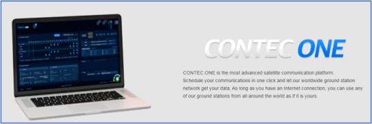
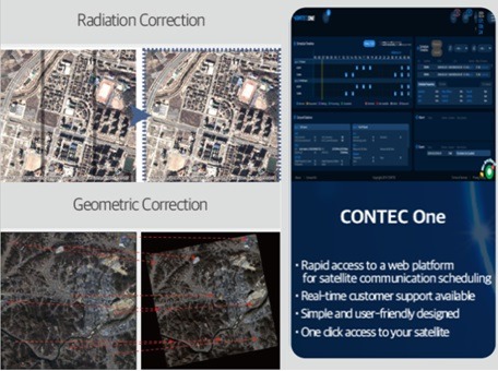
CONTEC ONE Service Concept and Features:
CONTEC ONE is the most advanced satellite communication platform. Schedule your communications with one click and let their worldwide ground station network transmit
your data. You can use any of their ground stations from around the world as if they were your own, as long as you have an Internet connection.
Ø TT&C available: They provide satellite data receiving through TT&C
Ø Pre-processing of your data: They not only receive your raw data, but if you need it, they can also process it so that you can efficiently use it.
Ø Post-processing as per your needs: If you need to detect objects (cars, buildings, etc.) from your data, they are able to provide satellite image object detection application services
Ø Support for your launch mission: Launching is not a problem either! They can help you with launching support for your satellites.
If you are looking for a space ground station service for satellite operations, you can find them at Contec.
Click here to contact Contec.
View more: CONTEC Easy-To-Use Ground Station Services for Satellite Operations
0 notes
Text
Satellite Image Application and Analysis Services in Korea | CONTEC
CONTEC provides satellite image application and analysis services in Korea. They perform object detection and change detection for monitoring smart cities.
Contec currently has multiple teams of engineers divided into two different offices in Korea and Luxembourg as its subsidiary, with more than half of them having at least a Master's degree and the heads of these different teams having at least 10 years of experience in the space industry. They are attempting to provide meaningful value to prospective customers by utilizing these services and powerful manpower. At Contec, they strive for excellence and believe that only talented people can achieve this goal.
Contec is rapidly expanding and plans to have 12 GSs outside of Korea by 2024, including Chile, Alaska, Europe, South East Asia, Africa, and Australia. Customers can download data from the web-based CONTEC ONE customer interface and easily schedule satellite passes. It can enable pass reservation with a single click. The best part is that customers with a secure internet connection can use registered Contec ground stations from anywhere on the planet.
Contec Satellite Image Application Service
Contec satellite image application service is web-based satellite image data analysis service. This application is able to do object detection and change detection by using satellite images. This can be very much useful for monitoring disasters, stopping unlicensed constructions and observe changes in SMART cities.
Satellite Image Application Service Features
Satellite raw data is processed with radiometric, spatial, and geometric data correction and quality enhancement.
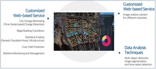
Customized Web-based Service
Ø City change monitoring (Time-Series based change Detection)
Ø Illegal building crackdown
Ø Statistical analysis (Densely Populated Areas, Infrastructure)
Ø Crop yield prediction
Ø Maritime Monitoring and Management
Ø Image analysis solution for different industries.
Data Analysis Techniques: Multi-object detection, image segmentation, and time-series detection.
If you are looking for a satellite image services in Korea, you can find them at Contec.
Click here to contact Contec.
View more: CONTEC Satellite Image Application and Analysis Services in Korea
0 notes
Text
Space Ground Station and Satellite Image Processing Services | CONTEC
CONTEC is a Korean provider of space ground station services as well as satellite image processing and distribution. It provides high-resolution satellite images to customers in a variety of industries.
Contec Space Ground Station Service
Contec provides advanced but easy-to-use ground station services for satellite operations. Contec's ground station expands its network worldwide (North America, Europe, Africa, and Asia), allowing continuous monitoring of your spacecraft.
CONTEC ONE Service Concept and Features:
CONTEC ONE is the most advanced satellite communication platform. Schedule your communications with one click and let their worldwide ground station network get your data. You can use any of their ground stations from around the world as if they were your own as long as you have an Internet connection.
Ø TT&C available: They provide satellite data receiving through TT&C
Ø Pre-processing of your data: They not only receive your raw data, but if you need it, they can also process it so that you can efficiently use it.
Ø Post-processing as per your needs: If you need to detect objects (cars, buildings, etc.) from your data, they are able to provide satellite image object detection application services
Ø Support for your launch mission: Launching is not a problem either! They can help you with launching support for your satellites.
Contec Satellite Image Pre-Processing Service
CONTEC's pre-processing of satellite images is applied to calibration algorithms to correct radiometric, geometric, and spatial distortions.
Features of Satellite Image Pre-Processing Service
Ø Radiometric Correction: Image pattern/system noise cancellation
Ø Spatial Correction: Image resolution and quality enhancement
Ø Geometric Correction: Geometric correction with satellite positioning/ orbit information.
Ø Quality Evaluation: Image radiometric/ geometric quality evaluation.
Ø High-speed processing: Mass data high-speed processing.
If you are looking for a space ground station and satellite image processing services, you can find them at Contec.
Click here to contact Contec.
View more: CONTEC Space Ground Station and Satellite Image Processing Services
0 notes
Text
Satellite Image Pre-Processing Service | CONTEC
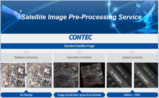
CONTEC has been as a top satellite image processing and satellite image distribution service as a whole-ground integration solution provider in Korea.
Contec Satellite Image Pre-Processing Service
CONTEC's pre-processing of satellite images is applied to calibration algorithms to correct radiometric, geometric, and spatial distortions.
Pre-processing operations, sometimes referred to as image restoration and rectification, are intended to correct for sensor- and platform-specific radiometric and geometric distortions of data. Radiometric corrections may be necessary due to variations in scene illumination and viewing geometry, atmospheric conditions, and sensor noise and response. Each of these will vary depending on the specific sensor and platform used to acquire the data and the conditions during data acquisition. Also, it may be desirable to convert and/or calibrate the data to known (absolute) radiation or reflectance units to facilitate comparison between data.
Variations in illumination and viewing geometry between images (for optical sensors) can be corrected by modeling the geometric relationship and distance between the area of the Earth's surface imaged, the sun, and the sensor. This is often required so as to be able to more readily compare images collected by different sensors at different dates or times, or to mosaic multiple images from a single sensor while maintaining uniform illumination conditions from scene to scene.
Features of Satellite Image Pre-Processing Service
Ø Radiometric Correction: Image pattern/system noise cancellation
Ø Spatial Correction: Image resolution and quality enhancement
Ø Geometric Correction: Geometric correction with satellite positioning/ orbit information.
Ø Quality Evaluation: Image radiometric/ geometric quality evaluation.
Ø High-speed processing: Mass data high-speed processing.
If you are looking for a satellite image pre-processing service, you can find them at Contec.
Click here to contact Contec.
View more:
CONTEC Satellite Image Pre-Processing Service
0 notes
Text
Space Ground Station Service for Satellite Operations | CONTEC
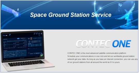
CONTEC, which was founded in January 2015 as a spin-off from KARI (Korea Aerospace Research Institute), provides space ground station services, satellite image processing and application services, and a whole ground integration solution. Contec currently has multiple teams of engineers divided into two different offices in Korea and Luxembourg as its subsidiary, with more than half of them having at least a Master's degree and the heads of these different teams having at least 10 years of experience in the space industry. They are attempting to provide meaningful value to prospective customers by utilizing these services and powerful manpower. At Contec, they strive for excellence and believe that only talented people can achieve this goal.
Contec Space Ground Station Service
Contec provides advanced but easy-to-use ground station services for satellite operations. Contec's ground station expands its network worldwide (North America, Europe, Africa, and Asia), allowing continuous monitoring of your spacecraft.
CONTEC ONE Service Concept and Features:
CONTEC ONE is the most advanced satellite communication platform. Schedule your communications with one click and let their worldwide ground station network get your data. You can use any of their ground stations from around the world as if they were your own as long as you have an Internet connection.
Ø TT&C available: They provide satellite data receiving through TT&C
Ø Pre-processing of your data: They not only receive your raw data, but if you need it, they can also process it so that you can efficiently use it.
Ø Post-processing as per your needs: If you need to detect objects (cars, buildings, etc.) from your data, they are able to provide satellite image object detection application services
Ø Support for your launch mission: Launching is not a problem either! They can help you with launching support for your satellites.
If you are looking for a space ground station service for satellite operations, you can find them at Contec.
Click here to contact Contec.
View more:
CONTEC Space Ground Station Service for Satellite Operations
0 notes