
Last Seen Blogs

children-of-the-moon13
🌙Moonchild🌙

bleakboxofinsights
lino.

suniling
SuniLing!!

fyebunny-blog
SkyePie

cityonmyfeets
林柒柒是骗子!
Text
Devil's Thumb via Lake Agnes - Banff National Park
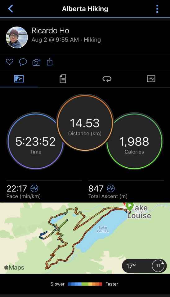
Location: Banff, AB
Date: August 2nd, 2023
Length: 14.53 km
Weather Conditions during hike: 14C - 26C, Mainly Sunny
This was not the first time I hiked this trail, but the first time where I've successfully summitted the Devil's Thumb. My first attempt took place last year late June.
Woken up to a gorgeous sunrise on our last day in the Town of Banff, and appreciated the beautiful landscape one last time before heading out to Lake Louise and Moraine Lake, our next stop of the trip. Before beginning our hike we decided to check out Moraine Lake first.

As we got off our bus at the parking lot, we were already admiring the scene around us, eagerly walking towards the main attraction; and as always, Moraine Lake never failed to disappoint. Surrounded by the vast expanse of nature, the mountains appeared so quiet from the distance as we admired from afar. The reflections of Moraine Lake gave off a feeling of peace and clarity, even more so during the wee hours of the morning. Despite arriving close to 9 am, we already found ourselves among a multitude of tourists, nonchalant about their way as they walked on the designated paths to the lookout point. Nonetheless, our experience was as pleasing as we hoped.
After completing our mini tour of Moraine Lake, it was time to hop into the shuttle bus to our next destination: Lake Louise.
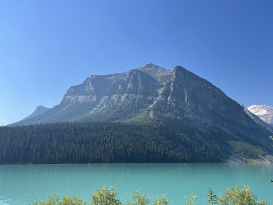
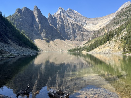
Lake Louise, much like Moraine Lake, did not fail to disappoint. With its turquoise water blanketing the lake and its surrounding peaks, making it a beautiful sight to behold. We began our ascent to Lake Agnes through the trailhead on the east of Lake Louise, traversing switchbacks, and enjoying the views as we gained elevation. This section of the trail was packed as we also shared it with horseback riders. You could see paths of horse poop as we walked along the trail. The ground itself was mainly flat with some exposed rock and root, so we had no issues navigating the trail. We stopped by Mirror Lake and took a small break. From here we could see the Big Beehive peak reflecting on the surface of the lake.
We continued our ascent through the trail on our right of Mirror Lake, and the further we were up, the closer we could see the Big Beehive from our point of view, signalling our approach to Agnes Lake. After a moderately challenging hike, we finally arrived at our main stopover destination. We rested a bit longer here, took some photos and continued our hike to the Big Beehive.
From here onwards the hike became a bit sketchier. The trail began narrowing, and we were more careful with our footing to ensure we didn't become a sprained ankle casualty. As we circled Lake Agnes, we approached a series of narrow and steep switchbacks, which would lead us directly to the plateau where the Big Beehive is. It was a slumber, but manageable walk. We went slow but steady, with each step gasping for more air. Once we reached the end, we took a deep breath. From here onwards, getting to the Beehive viewpoint was straightforward.
We sat by the edge with a nice view of the Fairmont hotel and the lake. Such an epic view for a lunch - I had a peanut butter & jam sandwich; a classic. And a bottle of protein shake to wash it down, delicious.
After taking our much needed rest, it was time to tackle the hike's biggest challenge - the Devil's Thumb. On my last trip, the trail leading to the peak from the Big Beehive was still pretty much covered in snow, so I had no choice but to skip this section and continue with the hike without completing the ascent. I was determined to make it this time, and during this time of the year the snow has cleared, revealing the path to the peak.
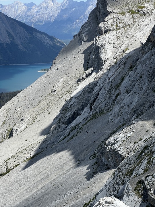
After backtracking from our rest area, we were back at the junction where we came from Lake Agnes. We continued our route to proceed with the Devil's Thumb peak until we reached a wall with ridges. We climbed up this section until we found our footing on the path to our left. This path circles the bottom of the peak leading us to its rear side. It is very narrow, and much of the time it was exposed on our left side, where we could see the at the bottom there was the river that fed the glacier water into Lake Louise. We were extra careful and went slow and steady. I couldn't deny the views were amazing all the way.
Once we reached the rear side of the peak, we had to scramble up. It was difficult, but doable. A couple ahead of us decided it was too much for them so they turned around and headed back. There were also plenty of other folks who made their way up so making sure we all agreed to this was key in order to proceed with this section. It was a strenuous ascent, gasping for air with every inch we were up, and holding on to whatever exposed root or rock we could for support along the way. After finishing this section, we were almost there. We would have to worry about coming down later, but for now we just wanted to get to the top. The path here was pretty straightforward until we reached a rocky section to climb to the peak. This climb was fairly easy compared to the ones we did before.
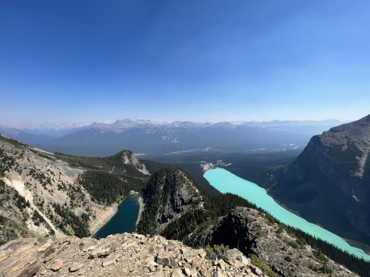
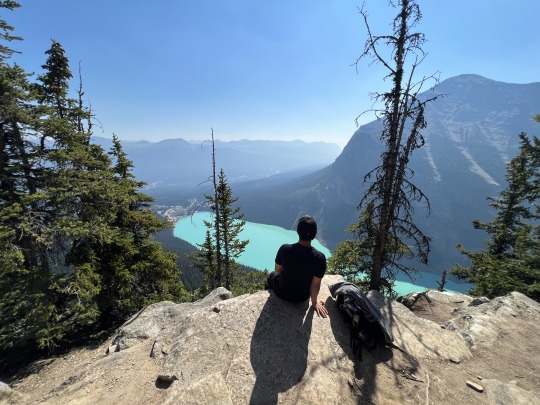
Our view from Devil's Thumb. Note Lake Agnes to the left, and Lake Louise to the right. Big Beehive can be seen between the two lakes.
Our views here were nothing short of eye-popping and jaw-dropping. I felt a weight being lifted off my shoulder, having finally being able to conquer this peak. I savoured every second of this moment, ignoring the winds blowing past us. We took several photos and videos of the view, had our snacks with hydration drinks, and finally made our way back. Having walked past this route on our way in, we felt more confident heading back to the Big Beehive/Lake Agnes junction, where we then took the trail leading us to Lake Louise.
We rewarded ourselves with ice cream from a stand in the Fairmont Royal, and a fun canoe ride on Lake Louise. We were tired in the end, but nonetheless had an amazing hike.
The entire hike was completely doable, provided you're in decent shape and have good cardio exposure, and I would also recommend doing the Devil's Thumb section if you're up for the challenge, keeping in mind that it's relatively trickier than the rest of the hike. Otherwise you'll still have a great time even if you do decide not to tackle this peak. The Big Beehive still provides satisfying views nonetheless.
Happy Hiking!
0 notes
Text
Tunnel Mountain - Town of Banff

Our view at the summit of Tunnel Mountain.
Location: Banff, AB
Date: August 1st, 2023
Length: 6.7 km
Weather Conditions during hike: 20C - 25C, Sunny
Easiest hike of an elevation in Banff. No more need be said.
Situated just south of the Town of Banff, Tunnel Mountain offers its visitors a fairly straightforward ascent to the summit with great views of the surrounding town. Out and back, our hike took us about 2 hours to complete. The trail itself wasn't too technical, although it may pose a challenge to people with little cardio exposure as it is completely uphill through a series of switchbacks. However, the hike does provide satisfying views the higher we went. It also seems to be a popular trail for trail runners as we noticed several of them during our hike.
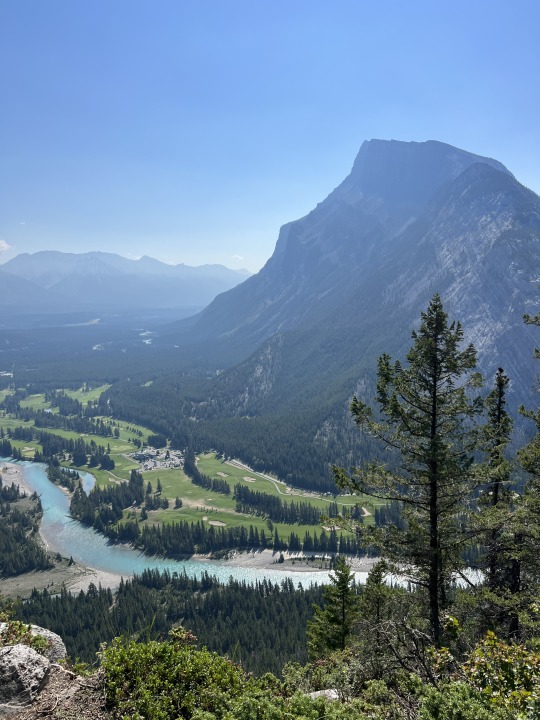
The south side of Tunnel Mountain - view of Mt Rundle
The southern side of the mountain rises into a cliff, and it appears to be popular among climbers, as we noticed quite a few attempting to scale it. An interesting sight indeed.
I rate this trail as Moderate as it is fairly steep and paths become slightly narrower the further up you go. It is a highly trafficked area so please practice proper hiking etiquette and wear proper hiking footwear to prevent slipping up over loose rock as there are quite a bit near the summit.
This was more of a recovery hike for us as we completed 2 challenging hikes back-to-back. At the end of today's 'mini' hike, we wrapped our day by going to the Banff Hot Springs and felt renewed afterwards.
Happy Hiking!
0 notes
Text
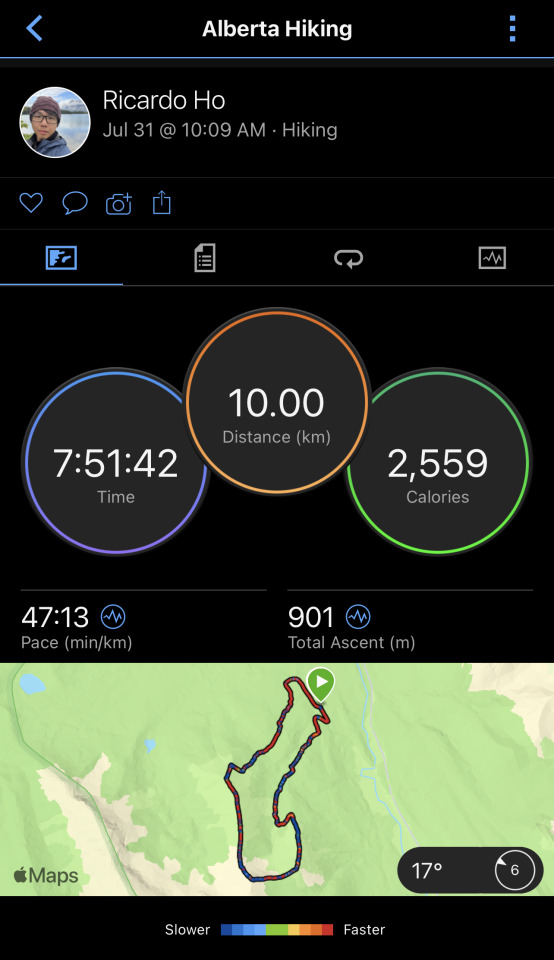
Tent Ridge - Spray Valley Provincial Park
Location: Kananaskis, AB
Date: July 31st, 2023
Length: 10 km
Weather Conditions during hike: Low of 10C, High of 25C. Mainly Sunny with limited visibility in the afternoon through the evening due to wildfire smoke.
This was an interesting hike, and an incredibly challenging one at that. Even though we 'only' hiked 10 kilometers, it took us nearly the equivalent of an entire work day to complete, and with good reason.
Here's why:
My cousin sprained both his knees and insisted on joining the hike with us, after we repeatedly discouraged him from doing so.
Over half of this hike took place on the ridge itself.
We were not used to climbing/scrambling, which was a large component of this hike.
This very popular trail, featured on Instagram and with thousands of good reviews on Alltrails, requires a lot of patience and determination to complete, but the views are absolutely worthwhile.
The trail welcomes you with an uphill walk, and gradually grows steep until we reach an open valley, where we took a small break, then finally into the beginning of the actual ascent, at around the 3-kilometer mark. The path is simple to follow but steep and with loose rock. We approached 2 walls we had to climb up, and sometimes we found ourselves looking down as we carefully walked on exposed narrow path. It was our second time doing a hike this challenging, but seeing multiple groups of people that day helped boost our morale and thus keep us motivated.
As soon as we climbed past our second wall, it was a relatively straightforward walk to the Weather Station, our first viewpoint.

Our view of the Weather Station. Approx. at 2440m altitude.
The weather station was not the actual peak - the highest point of the ridge was at the other corner of the ridge. We took a 30 minute break to appreciate the panoramic vista from our vantage point. It was as impressive as we had expected. My cousin Andy, who had his sprained knees, was not entirely thrilled about it. I wouldn't be enjoying it as much either in his shoes, since I would most likely be focusing on the pain in my knees.

Standing here and basking on the scenery, makes me feel so tiny, yet big at the same time, and grateful to be part of this adventure.
Continuing our hike from the Station, we had to descend into a small valley before going up another steep incline to the peak of the ridge. It wasn't as tricky as our first climb, but the grade truly tested our cardio capacity to the full extent. We saw a grizzly bear come out of the trees at the lowest point of the valley. We were about 50 meters away from each other before it noticed us and made eye contact. I remembered to make some noise so I waved at it and said "Hello" loudly. That seemed to have scared it because it quickly went back into the forest, never to be seen again.
Standing on the U section of the ridge, before our steep ascend to the peak.
After going up the grueling ascent, we finally reached the peak. I wanted nothing more than to just sit there and stare into the horizon, but as you can probably notice, smoke from the wildfires started to creep into the lake ahead.
My view at the peak. I could already notice the visibility taking a hit from the smoke.
The remainder of the hike was relatively 'easier' compared to our first half. That is not to downplay the difficulty of the hike, but completely doable as long as you walk slowly and methodically. Once we reached the other end of the ridge, our energy reserves were almost depleted. We were just glad that after almost 6 hours on high altitude we were on home stretch. Unfortunately, by the time we reached there, most of our view was covered with heavy smoke. We could still see the lake but nowhere near as clear as earlier during the day.

The beginning of the descent ahead, with poor visibility of the Spray Lake
After another hour or so, we approached our rental, breathed a sigh of relief, and left the parking lot. We were one of the few remaining cars on the lot.

Well, aren't you a sight for our sore eyes.
This hike was an eye-opener for me. It deepened my love for the activity and made me aware of how limited my exposure to the vast diversity of nature was. I also learned to be more careful and conscious of how to approach challenging sections of trails. I wished I had my hiking poles on this trip, but having said that it is still completely doable. I would recommend this hike for hikers looking for a challenge and are well-exposed to various levels of terrain, have good cardio, and some rock climbing experience. Lastly, as long as you practice safe hiking and proper trail etiquette you will have a great time on the trail! The views are absolutely worth it.

Our reward after today's adventure.
Happy Hiking!
0 notes
Text
Mt. Sarrail - Peter Lougheed Provincial Park
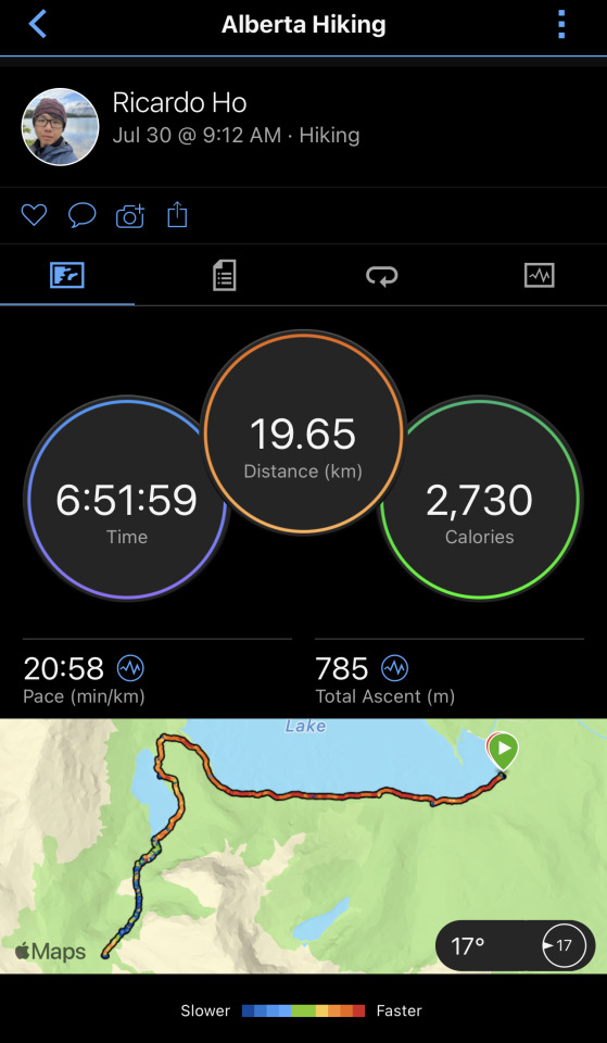
Location: Kananaskis, AB
Date: July 30th, 2023
Length: 19.65 km:
Weather conditions during hike: low of 10C, high of 25C - Mainly sunny until mid afternoon. Thundershowers for most of the afternoon throughout the evening.
Mission not accomplished. There were several factors that have contributed to my failed attempt at summiting Mt. Sarrail:
Underestimating the elevation change
Approaching thunderstorm the back half of the day
Hiking poles would've helped quite a bit
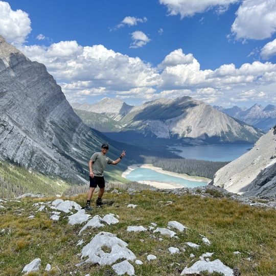
Despite mentioning the above, I still call the hike a success. I had a great time on the trail, and as we went higher, our views got better and better.
Even as an experienced hiker, it was still a gruesome hike, a statement which carries a lot of weight coming from someone who's used to hikes in Ontario. It required every bit of body coordination and endurance I could muster if I wanted to be able to carry on. After reaching the junction leading to the final ascent to the peak, I checked my watch and made the difficult conclusion that it wouldn't be possible to complete the summit on time before the stormed approached. I backtracked and headed back to the parking lot. Heading back was just as challenging as going up but was already aware what to expect. At the end of the day, this hike did provide a ton of useful information to become a better hiker:
Calibrating expectations
Proper pacing
Nutrition planning
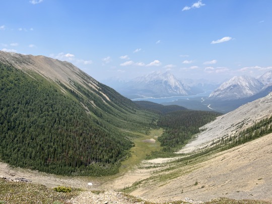
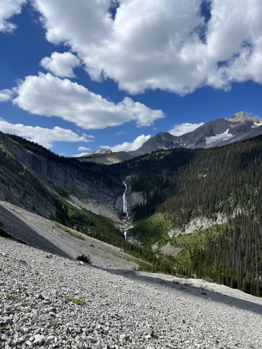
The diversity of wildlife and terrain makes up for the challenging aspect of this hike. I also saw a waterfall as it flowed from the Aster Lake up in high elevation into the Hidden Lake (see photo below).
Based on my experience, I wouldn't recommend this hike to anyone unless you're in good cardio shape, have some rock climbing experience, and are used to hiking at high altitudes. If you do decide to do this hike be prepared for an intense workout session; bring proper footwear, lots of fluids, layer appropriately as weather can change drastically with increasing elevation. Also don't forget bear spray of course, and other essentials like sunscreen, bug repellent and first aid. Hiking poles are highly recommended but not strictly required. To put it this way, I didn't bring them and regretted my decision at the end of my hike. Proper preparation ensures you have the best experience at enjoying the views this hike has to offer - and they are spectacular and jaw-dropping. It is definitely worthwhile of your time as long as it is done carefully and smartly.
Nature is beautiful but also merciless, and it deserves the utmost respect when traversing its vast terrain and appreciating what it has to offer. I can't wait to keep exploring and experience more of what the Canadian Rockies has to offer.
Happy Hiking!
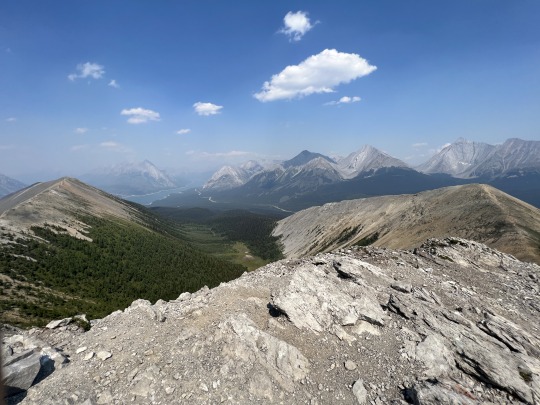
Me at the viewpoint just before reaching the final junction where I made the call to return to the parking lot.
A partial view of the trail we hiked on to get to the viewpoint. Notice a group of hikers we've met on the trail. They were a family of 5. Mom, Dad and 3 young kids! The youngest one didn't look a day older than 7 years old, and is already out exploring. I'm happy for them.
0 notes
Text
Devil’s Glen Provincial Park

Location: Glen Huron, ON
Date: July 23rd, 2023
Length: 10.2 km
Weather Conditions during hike: 23C - 30C, mainly sunny with periods of cloudy breaks
What I liked:
- Great views of the open field as we went through a loop as seen on the map above
- Good mix of terrain and elevation changes
- Trail passes through the area’s ski resort so you may or may not like that. We personally liked the added challenge of the uphill hike
- boardwalk bridges that go over small creeks and over muddy sections
What I didn’t like:
- Some sections of the trail we hiked were overgrown, hiding exposed roots. Due to this, we had to he extra careful. Especially the further we went in on the side trails.
Overall thoughts:
We did a slightly modified version of the hike shown on the Alltrails app, so instead of going further in and then turning back, we completed a loop via a side trail and then made our way back through the same path.
The trail goes past a ski resort so as long as you're only hiking you should be good to go. Simply walk past the closed gates and continue your way uphill. We enjoyed this bit as the added challenge was great cardio exercise.

Past the resort you will encounter open fields, and where we think was the best view of the hike, besides the top of the hill back on the resort. You'll reach an intersection where you could either continue forward on the Bruce Trail, or make your way back via a side loop. We chose the latter. The loop takes us back to the aforementioned intersection. From there we essentially backtracked to the parking lot.
Overall, we enjoyed the hike. It was muddy especially in deep shaded areas since it rained the day before. Mosquitos had a field day with us so a bug repellent is a must! In spite of these cons, we still had a great time on the trail. There was a great mix of terrain, elevation changes and the ground conditions were great despite the rain from the day before.
I rate the trail as Moderate - there were overgrown sections in the side loop with exposed roots, steep descents coupled with loose ground that can be slippery if not wearing proper shoes, and the uphill walk on the ski resort can be a challenge to those with poor cardio exposure.
Wearing proper shoes, bringing bug repellent and sun screen can make a lot of difference so it is always advisable to be prepared.
Happy Hiking!
0 notes
Text
Touch base
It is amazing to think about the things I thought I’d be unable to accomplish finally come to fruition. I was once restricted by the thought of my own limitations, the fear of failure and personal humiliation, only to realize in the end that it was all a blanket, designed to keep me out in the blind. In hindsight, I realized that it took a lot of courage to just lift it and take a peek. And I’m glad I did.
Yet, I still can’t believe that I’m already 31. The same age that my dad was when I was brought into this world. This realization, it frightens me. I feel that I’ve done a lot of work, but not enough to justify what I’ve been through in life so far. Is this something every person at this age goes through?
0 notes
Text
Me against the world
I fucking did it. I finally did it. As I sit alone on my campsite, late at night, signalling the end of Canada Day, I can finally say that I have done my first camping trip solo. I must say, it somehow feels completely liberating. My fears about undertaking this endeavour were unfounded. There is something special about doing this alone. Almost completely different, even though I’ve been camping for years. I finally popped this bubble, this barrier that kept me at bay, feeding my insecurity and keeping me blind from the things I’ve been missing out. I must say, I am glad this happened.
I thought it was the bears. Or maybe the mosquitoes. Heck, even other folks camping as well. I realized it was none of them. It was all an illusion, created by my own subconscious, designed to feed my insecurity, telling me that I was not made for this. Fuck all of it. I am as calm as I can be, and hungry for more, looking forward to the next solo experience.
I’ve already done my first solo hiking, then solo camping, also can’t forget my solo mountain biking experience. There is something mystical, peaceful about the word ‘solo’.
Solo, it’s just me against the world.
0 notes
Text
Sleeping Giant - Uncut Edition
Top of the Giant
Sleeping Giant - A 15hr drive towards an adventure of a lifetime (so far). I just had to be there to live the full experience. So I decided I would. I asked couple of friends willing to tag along, likely unaware of what was likely to unfold within the following couple of days. It was better to keep it that way, maintain expectations at a reasonable level. Let the experience speak for itself. I did the same, except that I had already read as many reviews as I could read, seen as many photos as I could have seen. It was time to take action.
The Plan:
The plan was this: Head out of the GTA on Saturday 18th, spend a night at a campsite on Lake Superior Provincial park, then continue our drive the following day. We were aiming to be at our campsite on Sleeping Giant Provincial Park by the end of the second day. Rest for the night, and begin our hike the following day. Return from the hike the same day, rest and begin our return drive on Tuesday. Without making any stops (except for gas and bathroom breaks), we should be back in town by Wednesday at dawn. The thought of driving 15hrs in one go haunted my guts, even for someone like me who is no stranger to long drives - my previous record was 8hrs, when I drove from Toronto to Quebec City.
The Drive:
On Saturday, we drove out just before sunrise. I was looking forward to so many things, the view itself, the hike, the other views leading up to the top, a chance to finally test my GoPro, etc,. I was not, however, looking forward to the drive. My friends offered to split the drive time but I refused. The reason was simple - I did not want anyone but myself driving my car. Not because I did not trust them, I just have this weird obsession with my car, I almost treat it as my significant other.
Having a small bladder, I knew we would inevitably have to make several stops along the way, more than I would have liked. My bladder hated road trips, but after all these years we somehow managed. There was nothing I could have done about this, unless I did it on a bottle while driving. Doable, but risky. So we opted for the more traditional approach, to simply stop by a gas station/rest area whenever we had to do our business.
The entire drive did have its redeeming qualities, I must admit. The views of the Lake Superior during our drive between Sault Ste. Marie and Sleeping Giant were gorgeous on their own. We had plenty of views of the lake from several spots at various heights, a ton of lakes traversed, and winding roads between hills. The view that caught our attention the most was the drive through a incredibly tall bridge across a valley. Saw a bunch of abandoned buildings, ranging from Gas Stations to motels throughout the drive. We were tempted to stop by one of them and explore it but decided against it due to our tight schedule.

It was also interesting to see the amount of looks we got during our stops in between towns to re-fuel or eat. Due to COVID restrictions at the time, in-door dining was not allowed, so we found ourselves eating on benches by the road or on wherever else we could eat that wasn't my car (yes, I also don’t allow eating in my car, myself included). Townspeople driving past us would almost undoubtedly take a good look at us as we were clearly not from around. One friend was wearing a Blue Jays cap and a Toronto Raptors Jersey. My other friend is East Asian, like myself, in a town in the middle of nowhere where one can hardly see any minorities around. We encountered similar situations in towns like Wawa and Marathon. Sault Ste. Marie wasn’t as noticeable but we did get looks at a fish and chips restaurant. Their food by the way was amazing, it is called Jack’s Fish n Chips, so if you do happen to be around make sure to check them out. Anyway, I do want to point that we never encountered a situation where we were poorly treated due to us being from out of town. We also did everything we had to do as quickly as we could. On the other hand, people were nice to us - we had a friendly interaction with a local when we did our shopping at Walmart during our stop in Sault Ste Marie. They noticed we were struggling to put the stuff we bought into my already packed car, and offered their help. We really didn’t need it so we politely declined, and thanked them for offering.
We also noticed that in Northern Ontario there’s this coffee chain called Robin’s Donuts. It caught our attention because the logo looked very similar to the one of Dunkin’ Donuts. The font and colour scheme used looked like they were obviously copied (at least to me), spelling Robin’s Donuts instead. We were so intrigued that we went to one restaurant at a gas station and each ordered a coffee. Our verdict: please stay away from their coffee. It’s mostly watered down coffee with sugar and milk. There’s barely any hint of coffee taste. If you are parched and there’s absolutely nothing else to buy, then by all means get it. If you’re looking for a jolt of caffeine don’t even bother considering it. It’s that bad. I cannot say the same about their other drink selections or food however, but given the impression we had after walking into the restaurant, I would not be surprised if it was just as underwhelming.

The Campsite:
Once my GPS has signaled us to make a left turn, we felt relieved to know that we were almost there. We drove for another half an hour along a 40km stretch of road.
Upon arrival we were greeted by a nice view of the Top of the Giant from the distance. It was pouring, so our main priority was to get to our campsite and set our tarps. The site we originally booked did not have shading but luckily, there were plenty of other ones to choose from. We asked the lady at the help desk to help us make the switch. We then set up our tents and tarps as quickly as we could and spent the remainder of the day drinking and eating. At 9pm, it was still raining and we had a long day ahead the next morning, so we went ahead and called it a day.
The Hike:

We woke up to a sunny and cool weather, which we welcomed openly after a full day of rain showers. You could smell the faint scent of the damp forest after a night of rain. We cooked some breakfast - nothing fancy, just some sausages, eggs, and bacon of course. And also, how could I ever forget the pleasant aroma of coffee to accompany our food. Fueled up, packed up and ready to embark on our adventure, I bring up my GPS to set up the coordinates (and for my Apple Watch as well) of our day trek.
Finding the trailhead took us a bit of guesswork, because our first attempt resulted us hiking a 2km side trail (named Sibley Trail), which was not even part of the trail we were supposed to begin our hike. It was relatively easy however, and most of the trail went parallel to a river, which was a nice plus. It was a loop so we ended on the same spot. Once back at the trailhead, I checked my GPS carefully this time, and noted that the actual trailhead was just about 500m away from where we were standing, straight down through the same road (Mary Louise Lake Rd) we walked from our campsite.
The actual trailhead in question is called Sawbill Lake Trail, which in reality is just a mini section that connects the campsite road with the main trail network forming a loop (Sawer Bay-Kabeyun-Talus Lake). The Talus Lake is the one with a trail that branches off into the Top of the Giant trail, our main objective, where the gorgeous views everyone takes pictures of is located.
We started from the south on the Sawer Bay Trail. The first 14kms of our hike were relatively easy (perhaps slightly moderate at times), traversing well-maintained terrain, clear signage, wide and mostly flat corridors. Bikes were allowed on the Kabeyun Trail as it was entirely flat. It somehow felt like the calm before the storm, as we already had an idea what to expect on the last 5kms leading to the top, therefore, we took our time as to budget our energy levels accordingly. Once we reached Talus Lake, we were greeted by signs letting cyclists know that from this point onwards, bikes were not allowed on this section of the trail so they had to be left there. Since we went on foot, it was not a point of issue for us, so we continued ahead. We quickly realized why - the path itself was not suitable for bikes as there was a lot of climbing involved, weaving terrain and at a couple of times, extremely narrow and steep descents. Note that the actual ascent to the top of the giant did not happen on this trail.
As soon as we reached the Top of the Giant trail, we almost immediately began our ascent through a series of switchbacks - indeed a gruesome experience, especially if your cardio condition isn’t great. Not impossible but also not pleasant. Luckily, it it didn’t last that long but it felt like it did. Once we reached the end of the main ascent, we quickly noticed that it was worth it - the higher we went, the better the views got. I brought my drone with me and wanted to fly it and take a video from above, only to realize that I forgot to install the required app on my phone. Without a signal in range I was unable to proceed, which was a slight disappointment, but I didn’t complain too much, as I quickly forgot about it when I went back to appreciating the gorgeous scenery from our current height.
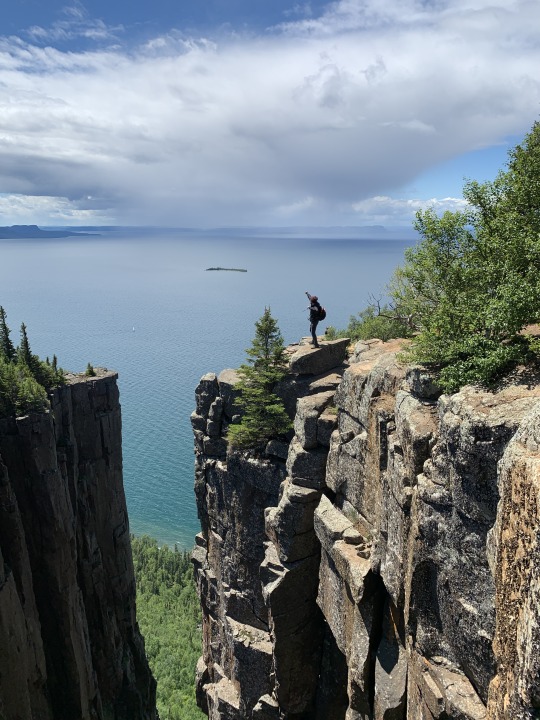
We hiked a bit longer - with each step feeling like time slowed down, and I almost couldn’t wait any longer. Then, it happened, as we arrived to our destination, my jaw immediately dropped at the same time my wide open eyes were left basking in the scenery that lied in front of me. My expectations not only were met, they were exceeded. The massive cliff, incredible height, and overlooking Lake Superior, all just stood there, undisturbed, and ever so serene. I did the touristic stuff, like taking photos and selfies, to get it out of the way, then sat by the edge closest to the end, and laid down for a while, simply breathing the air and enjoying the moment. We were also fortunate to only see a few souls on this area so for a while we had it all to ourselves. This is one of the places that deserves a revisit, and for good reason.
One hour later, clouds began gathering above us, thus signaling our time to begin our return hike. We traced our steps back to the beginning of the Top of the Giant trail, and headed north on the Talus Lake Trail. This trail was rated Hard for a reason - just when we thought the most difficult part of the hike was over, we were once greeted by incredibly varied terrain, steep elevation increases, and heavy vegetation. One section of the trail even crossed a contraption that looked like a dam built by beavers. It looked flimsy but it was actually dam sturdy (pun intended) upon crossing it. I was impressed by how strong it felt and knowing how capable nature is, and being able to live it. Truly this is one of the many great things about hiking. This back half of the adventure tested our endurance to its limits. My Apple watch and GPS both died several kms into the return hike, causing to lose my tracking. We barely managed to arrive at our campsite just moments after sunset. We mostly dragged our exhausted bodies the last 5kms of the journey, and as gruesome as it was, we all agreed that it was a worthwhile endeavor, and a great story to tell others in the future.
We each sat on our camping chairs, drank to our hearts content, cooked then ate a sizable quantity of delicious food (steak, potatoes, to name a few) to replenish our depleted reserves. After plotting our actual route on AllTrails and Google Maps, it all came down to a 43km long trek, completed in just over 12hrs. I call that a resounding success, easily earning a 5-star rating in my books. Intense, and almost maddening to a point, but worth it. Would I recommend it? If you’re in good physical condition and looking for a challenge then I would readily do so. However, if you’re just looking to see the Top of the Giant lookout, you could just park on the Kabeyun trailhead and make your way from there. You could even bike the this section of the trail if you want to. Just keep in mind that once reaching Talus Lake trail, bikes must be left there before proceeding. There are racks the park has provided to secure them. All in all, regardless of how you get there, the views are absolutely stunning!
As usual, come prepared - bring lots of fluids and snacks/food, bear spray (even if in group), and proper footwear.
The Summary:
If I had to summarize my entire experience, it would be:
Exhilarating
Jaw-dropping
Strenuous
Almost even magical
I would use these words to describe my 43km saga on the Sleeping Giant Provincial Park. Easily one of my top hikes without a doubt. Happy Hiking!
Photos Below:

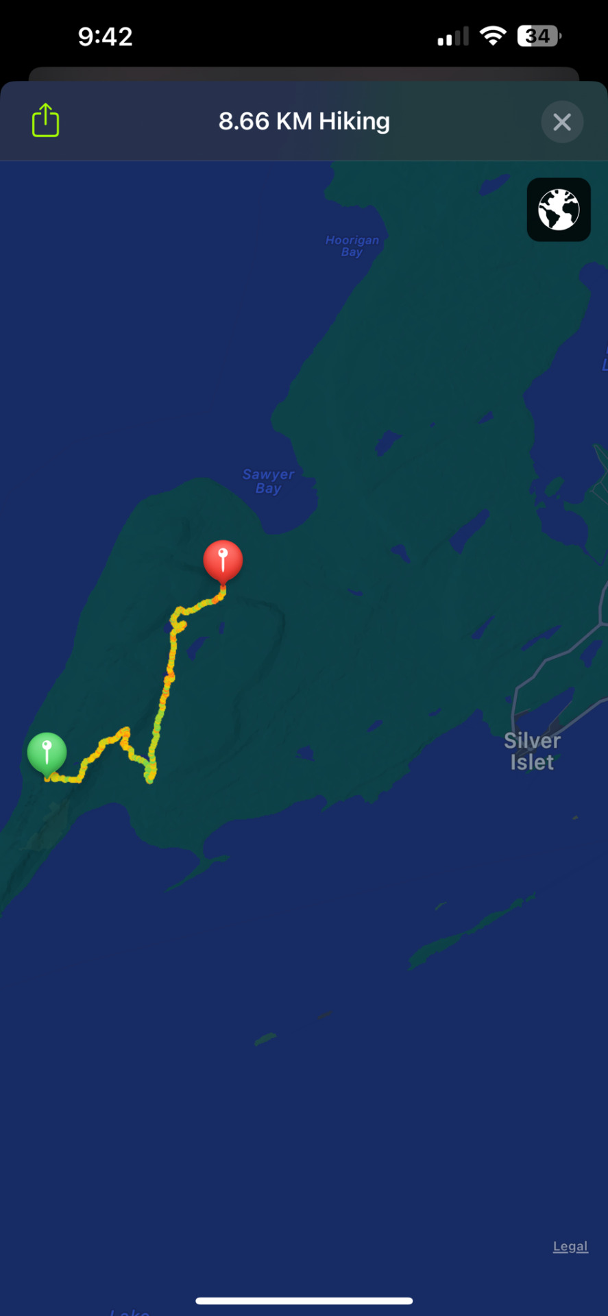
Stopped tracking at the lookout point in order to conserve my watch's battery life. Tracked another 8.7kms of my return hike before it finally died. The remaining 13 kms were not recorded.

Top - View from the edge of the cliff
Bottom Left - Northern section of the Talus Lake Trail where we had to cross a beaver dam
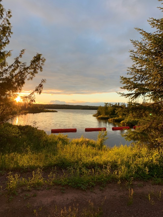
Bottom Right - Mary Louise Lake Road around Sunset
0 notes
Text
Killbear Provincial Park
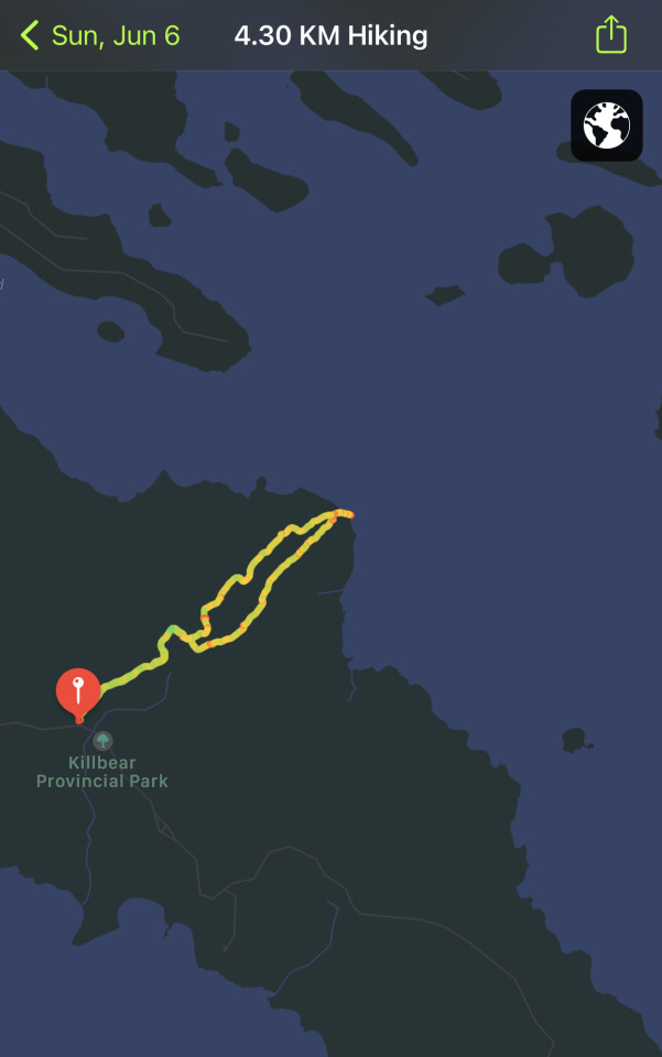
Location: Nobel, Ontario
Length of Hike: 4.30km (plus another 3km not shown on the photo above)
Weather Condition During Hike: 23C - 30C, Mainly Sunny with periods of cloudy breaks
What I liked:
- Beautiful view of the Georgian Bay at the lookout point
- Great mix of terrain. Rocky as we reached the coast, with sand spread across the trail.
- long sections of the trail were on boardwalks
- Interesting wildlife encounter - A black bear (yes!), turtle, deer, several toads, and lots and lots of dangling caterpillars. Some might not find them fun but to me it was.
What I didn’t like:
- poorly maintained trails, mostly on the northern section of the trail, on our way back
- some signs missing but trails were not confusing to follow
Overall thoughts:
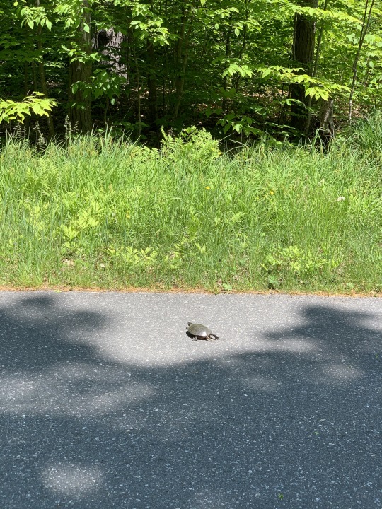
A short hike, but nothing short of interesting! The highlight of this hike was a rather close encounter with a black bear. We realized it probably noticed us before we did so it started running away from us, but we managed to see it as it stopped. We made eye contact for a brief moment, before it decided to continue its journey deep towards the forest. We were terrified but at the same time excited to be able to live to tell the tale. Other, still interesting sightings was a small deer we caught a glimpse of while it galloped across the forest, several toads of various colours, and a small turtle we almost ran over while driving on the road. The only photographic evidence we have been able to capture was of the turtle. I would’ve preferred one of the bear but beggars can’t be choosers!
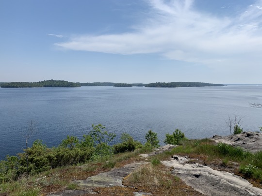
The lookout point was also one of the best parts of this hike. The view was beautiful and inviting. The rock formations towards the coast made a nice view and a great photo op. Given the hot day, we were tempted to dip our feet into the water but decided against it and just cool our hands. It was still almost freezing cold.
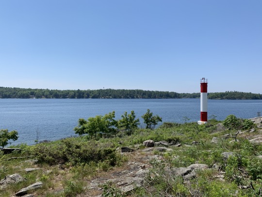
Since it was a short hike, we still had a lot of time left so we drove a bit further south towards the end of the road, closer to the beach. There was a small trail along the coast with a light house by the water. Lots of boats and jet skis could be seen travelling at high speeds. It somehow tainted the quietness of the lake.
At the end of the day, we agreed it was nothing short of eventful. The hike we took was short, but had a great and rewarding view. We were also lucky to see a handful of wildlife creatures, although we were a little disappointed that we were unable to see any rattlesnakes (which is good in a way). However, I am unable to give it a 5-star rating due to the fact that some sections of the trail lacked proper maintenance, such as overgrown grass, some signs were missing, but fortunately the trails were not so difficult to follow. I say this is a solid 4-star trail.
At this time of the year it is still advised to use lots of insect repellent, perhaps a stronger version due to ticks in the area. Not necessary but recommended for added peace of mind. Great trail for hikers of all skill levels.
Happy Hiking!
0 notes
Text
Boyne Valley Provincial Park

Location: Shelburne, Ontario
Length of Hike: 9.55km
Weather Condition during hike: 26C - 30C, mostly sunny with cloudy breaks
What I liked:
- Signs were decently marked
- Trails were properly maintained
- Nice view of the area at the top of the lookout
What I didn't like:
- some sections were very narrow therefore you have to watch out for mountain bikers
Overall Thoughts:
Even though we prefer longer hikes, the great mix of tall hills and winding terrain made it enjoyable while maintaining a decent level of excitement and activity on this sub-10km hike. This trail connects with the main Bruce Trail network so if you wish, you could extend your hike further, but we thought it would be best to stay on this side trail and just take it easy at a moderate pace.

Bridges were built on parts of the trail where the river is located, making for a great bridge photo opportunity. Also, a portion of this trail was located on the road, so we needed to be careful with cars. Although interestingly, we didn't see one on this 1km stretch of the hike.
Some sections were narrow - we were just hiking at a moderate pace until we bumped into a group of mountain bikers. So if you plan to hike on this trail, be mindful of them, especially if you find yourself at narrow sections on the trail. We were lucky enough to spot them before they noticed us and made and abrupt stop.
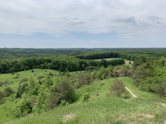
The best part of this trail is the lookout point, just a bit west from where we started the hike. If you follow the path shown on my photo above, it should be somewhere on the left side of what looks like a heart-shaped figure (I'm terrible at describing things!). Once you reach this point, you'll realize why you hiked this far, because it is all about the views.
Overall a great hike, for anyone of any skill level - one caveat though, depending on where you start your hike, you may have to go up on several hills. There is a trail entrance by the road west of the trail, so if you begin your hike there it will mostly be uphill for about 2kms. From where we began, which was where Google Maps took us and we'd recommend to start, it was relatively flat and going downhill, with maybe a little bit of ups and downs.
I'd give it a 5-star rating, for its great mix of terrain and views, and the bridges connecting the trail made the adventure more fun, for some reason. We were also lucky we did not get bitten by mosquitoes, which is a big plus. And if you're coming from Toronto, at just 1.5hrs away, I think it is a worth the drive.
Happy Hiking!
0 notes
Text
Provoking Lake Hike - Algonquin Provincial Park
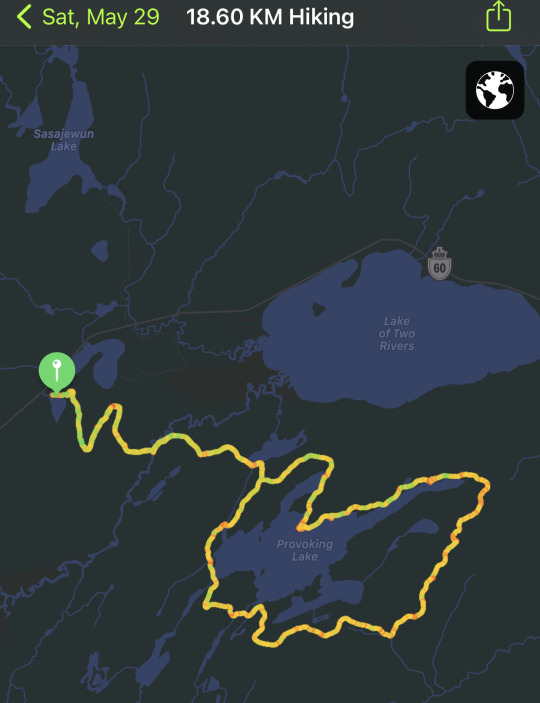
Location: Algonquin Provincial Park, Ontario
Length of Hike: 18.60 km
Weather Condition: Sunny, 12C at time of hike
What I liked:
- Trails were decently marked
- several great views of the lake
- backpacking sites were tidy and easily accessible
- Great mix of hills and challenging terrain
What I did not like:
- some sections of the trail were not properly maintained
- lots and lots of mosquitos (in all fairness, we hiked during peak mosquito season)
Overall thoughts:
- Generally a great trail to go on hikes, one of the many, and many that Algonquin Park has to offer. The path we took loops the Provoking Lake, then back to the parking lot. It also cuts through one of the longest backpacking trails on the park. Sadly, the only reason we were unable to fully enjoy the experience is due to the insane amount of mosquitos we encountered. They were basically everywhere. We were bitten by several on our areas with our skin exposed. As much as we managed to cover ourselves, and even as we walked, they somehow managed to slip into our clothing and bite us. We decided that the best course of action would be to skip our water breaks and finish the hike as soon as possible.
We were exhausted in the end as we reached the parking lot, but it was worth the hassle from any additional mosquito bites we could have had.
Now, the above does sound like a rant, and it wouldn’t be fair to fault the trail over a situation the park or ourselves have no control over. So I still believe this is a great trail, the signs are clearly marked, there is a great mix of hills and terrain to challenge your physique and help you workout, but not too intense to distract your enjoyment of the hike. I did notice however, that some of the sections of the trail, especially as we headed further south, were not properly maintained - lots of growing grass, tree branches, were abundant on these sections. And for these reasons, I am unable to give it a full score, if I were to range it between 1 to 5. I say this is a 4 out of 5, which is on par with the general consensus on AllTrails, and I can finally understand why.
My advice to fellow hikers on their first hike on this trail, I would not recommend visiting this trail during mosquito season (usually between late April and late May). But if you must, bring as much OFF! as you can, or a stronger version, as you will be needing it. Also, trails have lot of exposed roots and rock so exercise extra caution as you traverse through the terrain. Wear hiking shoes/boots if possible for added grip and ankle protection. I’m clumsy therefore, for me this was a must. I would rate this trail as moderate as it is a sub-20 km hike and good stamina is recommended to be able to complete it.
Happy Hiking!
0 notes
Text
Lightbulb Moment.
Friend: You go out on a lot of hikes.
Me: Yes.
Friend: You also have a lot of photos you’ve taken from your hikes.
Me: Yes I do.
Friend: Why don’t you blog about them? Have you ever thought about literally posting your video footage on YouTube? At least get some out for laughs?
Me: Hmmm... You might be on to something.
Hence this post’s inception. Thanks to my good friend’s suggestion, I decided that I’ll be documenting my experience on trails during my hikes, detailing them and maybe giving them a score of some sorts. This is not just some lazy attempt at a post - this should also serve as reminder of this undertaking I’ve decided to commit myself into. To at least get the ball rolling. Who knows, perhaps in the future, if this is something I really enjoy doing, I might even decide to make this available for everyone.
Not exactly like how my friend suggested for YouTube but definitely an idea I might eventually warm up to.
In the meantime, I’ll just keep this to myself. Let’s go.
3 notes
·
View notes
Text
Catching up
I wish the things in my life today were simpler like they used to be 10 years ago, even if it was just a little bit. And I know it would be naive to think it will become easier over time.
If I could just pause time so that I am able to catch up with life, because I’m feeling that I could be a little behind.
I could use a mental break.
0 notes
Text
Battlestation
There is this Sub in Reddit called /battlestations and I was thrilled in learning about it, so I made it my goal to make my computer setup as clean and neat as possible to be able to garner as many votes as possible
0 notes
Text
Inspiration
Music might be a common stress- relieving method for many people, but could, conversely become a stress-inducing endeavor. As counterintuitive as it may seem, our moods are dictated by the types of songs we listen to, not the other way around, at least that’s what I think.
My head hurts from thinking too much about this, how can I think of something to write about and not feel tired about it? Or at least not bored quickly about it?
How about adjusting the typing angle of my keyboard? It might be something to try and see if it helps?
0 notes
Text
Too Soon?
If I pull through, will it be too soon? How will I know if that’s the case? How soon is too soon?
I need time to think this through, to analyze, to judge, and hopefully be able to come up with a decision for the better.
0 notes