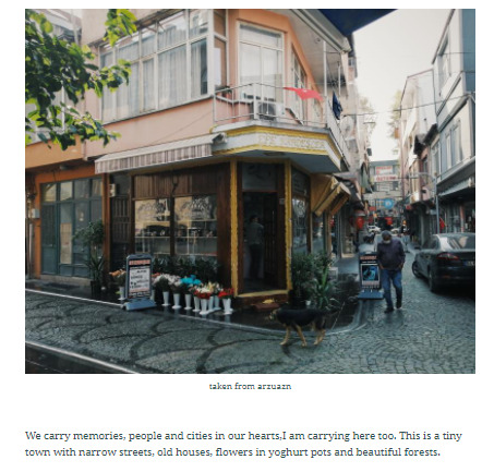
arzuazin
arzu azın
HELLO! I share my crp101 studio experiences.Can you join me in this way?
38 posts
Don't wanna be here? Send us removal request.
Last Seen Blogs

kryptoni-te
♡ ♡ ♡ ♡
theartofnito-blog
The Art of Nito

supernaturally-avenged
Sorry B, this is your vendetta

philomena-s
Please Don't Stop the Music

stansted-airport-taxi
Untitled
Photo
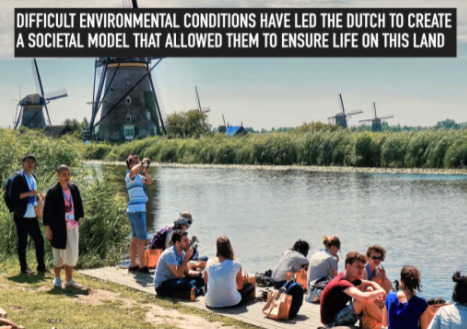
WATER MANAGEMENT AND DESIGN IN THE NETHERLANDS
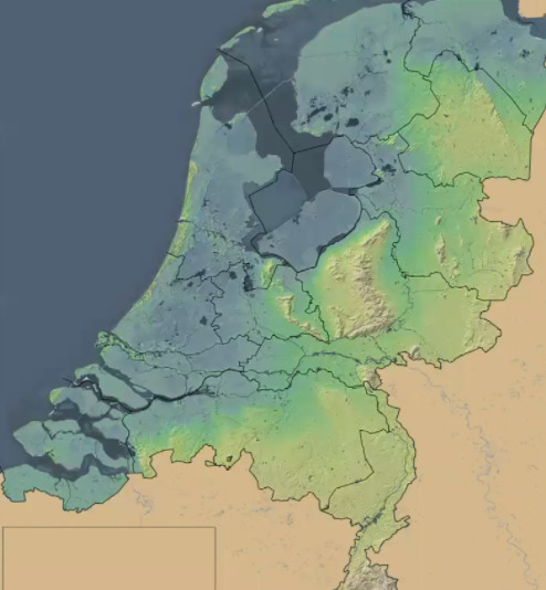
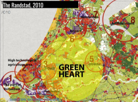
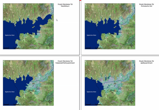
We hosted Roberto Rocco, associate professor of spatial planning at TU Delft in the Netherlands, in our studio. Roberto lives in the Netherlands and started his speech with the delta program here. He talked about water management for a climate-resilient future. The Netherlands was known as a low country. The blue areas were very close to the sea level in the attached image, even below the sea level. These were fertile areas for agriculture and fishing. Later, we talked about Randstad. Randstad is a unified city district in the Netherlands, formed by many large cities and small-scale cities.This place has good infrastructure and is also suitable for agriculture. Because the middle of Randstad is empty and covered with green space, this area is called the green heart. Activities in the region are spread around the green heart. Although the green space is primarily open and agricultural land, greenhouses have also been built. The green heart is also necessary for the water system. There was a deep harbor in the 1st place(2. image) because the Chinese ships had a deeper subzone. Since they could not enter the city, such a place was created for them. Number 2 is the place where agriculture is most intense. Even the houses in this area were used as greenhouses. Area 8 in image 2 was a place of water. They filled the sea with sand and created an artificial island. Cities and their formations are complex systems. In this system, culture shapes the soil, and the ground shapes the society. Humans have tried many things to overcome harsh natural conditions.
Then Roberto talked about the polder model. In the Netherlands, people lived in swampy land. The villagers made the land livable by digging and constructing dams according to themselves. The management of the water was also jointly managed by the landowners. As a result of the water flowing around a city or a piece of land, leaving this area in the middle and the ground being low structures between the parts of the land, the sites excavated from the sea formed polders. 'polder model' started to be used as the best form of cooperation. Water management was critical to the Netherlands, and the only way to manage water problems was to work together. These formations were quite interesting to me. There is a piece of land in the water, but this city is struggling with drought as well as floods.
He then spoke on How to Deal with These Water Problems.The Delta Program aims to maintain a healthy and safe environment today and in the future. Long-term planning is necessary for future growth. For this reason, we need to make planned developments against disasters, not short-term. Different sectors must work together for solutions to connect. For example, housing and transportation solutions have to work together; they cannot be considered separately. City and water systems and systems require joint and planned work. It is a correct approach to start the projects with small steps.
The importance of having a regional planning approach: Having a Regional Approach means dealing with regions and areas at the same time. On the contrary, it focuses on producing solutions by advancing in a part-whole relationship. In the Polder Model, the region is connected to a city and the city to an area. In this model, government proceeds at a multi-level with citizens, universities, commissioners, and governments. Thus, ideas are shared, interregional problems are solved jointly, and harmony is achieved. Also, by dividing larger and more complex systems into zones, small but adaptable solutions are provided. In addition, it will be easier to examine and test the operability of the ideas implemented in these small scales. If they fail, the financial loss will remain at a minimum, and the project's changes will be easier.
0 notes
Photo
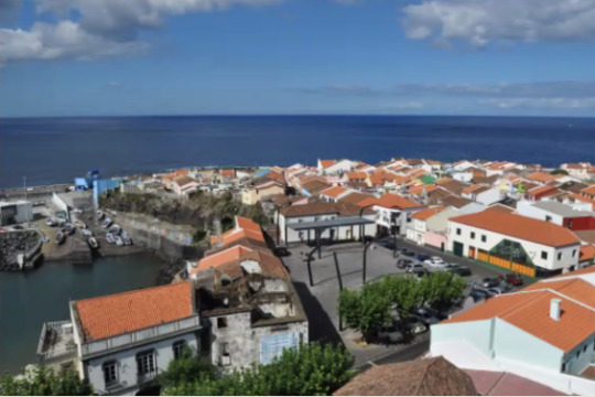
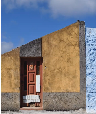

CITY SERIES #6 : An Island Within and Island ‘The case of Rabo De Peixe’
Ines Vieira Rodrigues, a Ph.D. candidate working at the Center for Architecture and Urban Studies FAUP, Porto, Portugal, was our guest at the studio. He told us about Rabo De Peixe for his presentation. Rabo de Peixe is a settlement in the middle of the Atlantic Ocean, covering three percent of Portugal's land. This area, which serves as a shelter for the port, is exposed to high solar radiation; its altitude is low and not steep.
The illiteracy rate in Rabo De Peixe is relatively high. We learned that most of the population is between the ages of 15-64, and the unemployment rate is relatively high. The economy is provided by agriculture and fishing here. Due to the lack of resources and the island's location, productivity is low, which people have turned to fish for this reason.Rabo De Peixe is divided into two areas by social stratification. The part close to the ocean is the "low zone." the rest is called the "high zone." These zones contain walls that separate them, which is the most apparent proof of classification to us. The lowland is related to fishing activities, and they are seen as 2nd class people. They have inadequate housing, overpopulation problems, and hygienic conditions. Unlike, The higher region has a milder climate and deals with the orange trade. Ines Vieira Rodrigues made the socio-economic asymmetry between the two areas quite striking using statistical data and visual support. Ms. Rodrigues argues that the Lowland area should undergo an urban transformation operation as soon as possible. The solutions that have not been focused on this area are superficial, and the short-term regional segregation creates quite a problem in urban flow.
The presentation reminded me of the problems we are experiencing in Turkey in general. Unfortunately, this social isolation is present in all areas of our country. It is unfortunate to see this on a city basis while the east and west are included in this isolation regionally. For example, while the Çankaya region in Ankara is more prosperous and has better conditions, Altındağ and Ulus The infrastructural problems in the surrounding area and the change in the profile of the people are obvious. The same situation, Istanbul also observed in some districts, especially with the density of tourists, while districts such as Tarlabaşı and Bağcılar are another side of the city. I want to end with the words of Karl Marx: ''It is not the consciousness of people that determines the material living conditions. These material conditions determine their consciousness.'' Maybe we can start from our cities to create better consciousnesses; we can provide more just, humane and homogeneous conditions to people with our plans.
0 notes
Photo
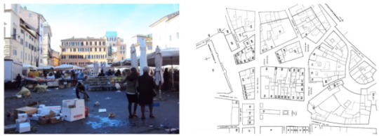

City Planning and Everyday: A Closer Look at Campo De'Fiori in Rome
Nele De Raedt, a guest in our studio, is an assistant professor, in Theory, History, and Criticism of Architecture at UCLouvain in Belgium. Her presentation topic was City Planning and every day: A Closer Look at Campo De'Fiori in Rome.
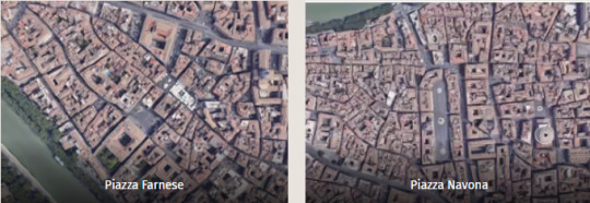
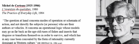
The conversation started with Piazza Farnese, a city-scale architecture, with a description of an important square. Another was Piazza Navona, the courtyard surrounded. Then we continued with the example of Piazza Del Popolo. Its connection to three main streets and its elliptical shape reminded me more of the squares in Turkey. Then we started our main topic by talking about the two French thinkers named Michel de Certeau and Pierre Nora. Michel de Certeau stated that we understand the boundaries while walking and observe our surroundings and that walking shapes the city in our minds. He explained this gait, in other words, human movements, which change according to the road, person and time, through daily life. Everyday life created creative practices and altered from their cities in line with these needs. Pierre Nora says that the formation of the memory of the space and its maintenance and meaningfulness depends on the social group. This memory can change over time with lived events, different needs, and activities. The formed Collective memory manifests itself quite comfortably in urban spaces with changes and transformations over time. Mrs. Nele De Raedt talked about Campo de Fiori and his daily collective life in light of these.
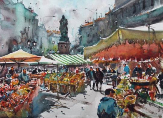
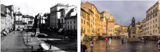
Campo De' Fiori made many changes in its planning. Rome, which had a lousy infrastructure before, was improved by the Pope as it was the European capital of Christianity. The fountain in the middle of the square was used strategically and became an important city element. The Pope restored the aqueducts. The project aimed to turn Rome into a precious Christian capital.This town square, which was of poor quality and poor condition in the 15th century, has become an important trade route with different projects to facilitate movement. It is successful planning in the street and port connection. By transforming the port into a commercial area, a more organized and developed space has been provided. The main problem in this square was that the water accumulated too much and damaged the bazaar's place. Therefore, the court was removed in the 19th century and created a new bazaar area.At the beginning of the 20th century, the Campo de Fiori market gradually turned into an important center for the market with its new plans and eliminating the water problem. It has turned into a collective daily space where people can put their belongings, buy things, walk and eat, and host many more daily activities. Although it changed and became more complex over time, it always maintained its importance. The city's identity, smell, sounds, and the image it creates in the memory play a significant role in this. This image has become a permanent area that is visualized in people's memory. We had already learned the importance of water for cities from Ali's presentation, but The Campo de Fiori was a tangible source. Water management was better planned, the area's functions increased, and the place turned into a more influential position.
After this presentation, the first place that came to my mind in Turkey was Taksim Square. Like Campo de Fiori, Taksim went through planning processes. Each government tried to shape the square in line with its ideology. The construction of the Taksim mosque was completed recently. Also, Campo de Fiori is a place where public executions and sentences take place.An example of this is the death of a philosopher, scientist named Giordano Bruno in Campo de Fioridue, to his differing views from the church. This event reminded me of the mass murder in Taksim square under the name of Bloody Sunday. Therefore,I found both courts very strategic both in terms of city memory and planning. As a result, spaces are changing day by day in the light of management, human and technical issues resulting from their use in daily life. However, it's up to us to design it for the benefit of the space.
0 notes
Photo

CITY AND NATURE COMPLEXITIES – THE CASE OF BRISBANE
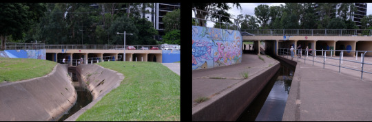
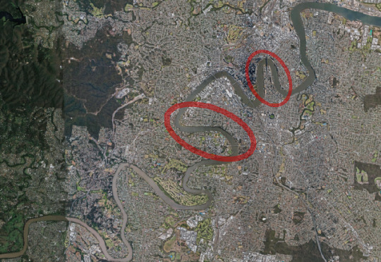
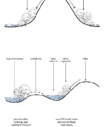
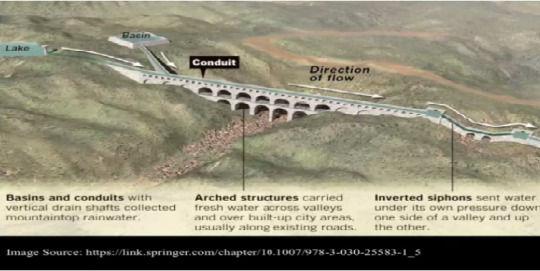
Ali Rad Yousefnia from the University of Queensland was our guest speaker who focused on the intertwined connections between nature and design, especially in the Brisbane case. We started with the subject of the relationship between the city and nature. Ali started his presentation by introducing natural elements, but the main emphasis was on the water. Water is one of the elements that affect cities the most. In this presentation, we saw that water could exist as an element of the town. Nature was shaping the city even if we didn't want it. Dr. Ali explained these through examples of aqueducts, wings in the Middle East, water beds (Ab Anbar), natural underground water resources, rivers, and sea connections. Then we discussed the effects of these water elements on the city. Living in harmony with nature starts with trying to control water, which is the source of almost everything. In hydraulic empires, control over the water was a symbol of power. Port cities developed thanks to the successful use of water because water meant agriculture, irrigation, transportation, trade, in short, life. Ephesus was one of these influential cities thanks to water. If not managed well rather than the advantages it provides, water could also turn into destruction in cities. Then we moved from Brisbane to its relationship with nature and especially water. Brisbane is an oceanfront city with hills and a river. After giving general information about the history and structure of the town, we compared Ankara with the data presented and examined the relationship between the two cities with nature and water. The Brisbane river covers almost the entire city, making us think about the city's future growth and how we should value this water resource. This river running through the city acts as an essential part of the city. The whole city can interact with water, not only because of its location but also because of its activities. This brings transportation and visual advantages as well as negativities. We learned that this river is classified as a reverse delta river; that is, it flows towards the sea and sometimes in the opposite direction. At the same time, water levels could fluctuate drastically. And a city clustered around the river would be affected by it in all circumstances. The rivers tend to bend in the flat area because they are affected so much over a long period, and the Brisbane River is also very meandering. This meandering river, which covers almost the entire city, makes us think about the city's future growth and how we should value this water resource. In addition, the grid system was applied to the town, and more curved, and grid system changes were used in the parts where the topography is inclined. After talking about Brisbane, we started to compare it with Ankara. The most striking difference was the green space per capita of less than 112m2 in Brisbane and more petite than 2m2 in Ankara. This condition has turned into a debate about urban sprawl and the concept of the shared suburb in Australia. The other comparison was how the measures were taken against the flood disaster that the city faced. It is located on a flood-prone plain in the Brisbane river delta. This area was an open space before rapid urbanization. With the settlements, the flood disaster started to damage daily life, people, and structures. As a victim of rapid urbanization, Ankara had to face the reality of flooding among the concrete. Urban growth is necessary, especially when it comes to a significant city. But how the city grows is very important. The main thing is to allow municipalities to expand, taking into account the advantages of green spaces and topography. Brisbane was designed to create safe spaces for water to circulate, rather than simply restricting water flow. In flat and sloping areas, water flow was taken into account, as well as the terrain. As a result, measures in harmony with nature were developed on both an urban and architectural scale. Because such problems were common before, it has been more efficient with designs created in the light of historical data.
At the end of the presentation, the work we did in Ephesus became more understandable. While water and topography offer us many advantages, they also provide disadvantages. Ignoring the problems may cause problems such as the floods in Ankara. An increase in urbanization may not decrease, but it is in our hands to design better areas. I realized that we get feedback on everything we do in nature, which sometimes reflects us as curves in rivers and floods in cities.
0 notes
Photo
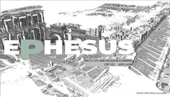
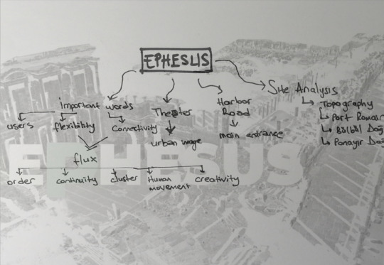
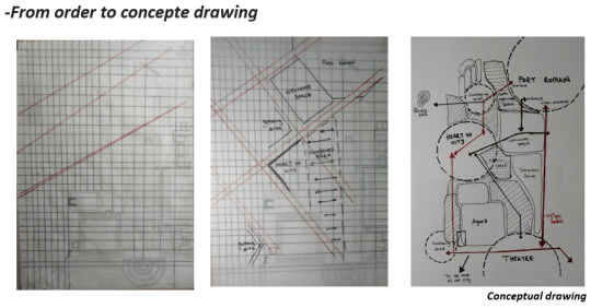
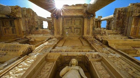
EPHESUS:THE LIVING RUINS
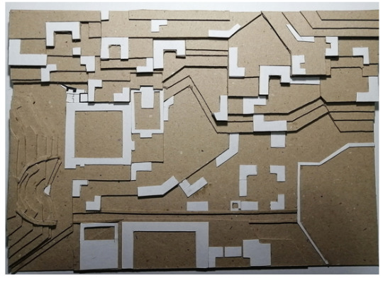
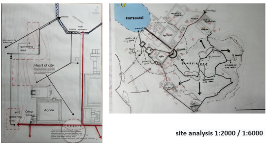
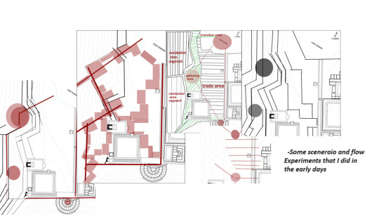
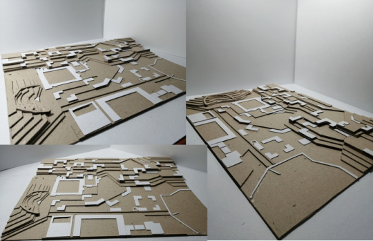
The midterm subject was the ancient city of Ephesus.First, we talked about the history of Ephesus, which is planning, the development, and change of the city. We progressed by learning slowly in the lessons for about three weeks. First of all, we examined the area and its environment and how it is in itself. We tried to understand them better by analyzing the site. In the site analysis, we gave importance to topography and water. Ephesus is an attractive city with an old history between the harbor and the mountains. We designed a city focused on human movement, thinking about how these areas were used and how they should be used in the past. We worked on a 1: 2000 scale in between the port and the theater. We analyzed and modeled it. How can I get the maximum benefit from this area, how can I combat the difficulties given by nature and turn them into opportunities why did this city disappear, and it would last longer if I design it differently? These questions became my focus.
0 notes
Photo
Asignment#3 StoryMap
Esra Aydın, who is a trainer in Esri turkey, talked to us about visualization with Gıs. She talked about how GIS-based programs make our lives easier, and that simplifies mapping and analysis. In the light of the presentation, we told us the place we live in, with maps, demonstrations, and conceptual we drew, in a half-story, half-academic language.
0 notes
Photo
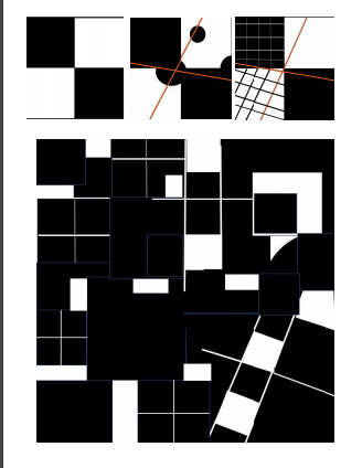
In Class Exercise_Aybüke&Büşra
Aybüke Tufan and Büşra Sönmez made a presentation to us as a visual representation tool in collage and spatial design.Afterwards, we created an impression by playing on the visual they provided and adding human figures.
I realized that the things we designed will gain importance only with a good presentation and expression.
Inference:The dimensions of the figures can be played with and the space may vary in size, but this is advanced and I haven't been very successful in this.However, it was a very enjoyable and instructive lesson.
0 notes
Photo
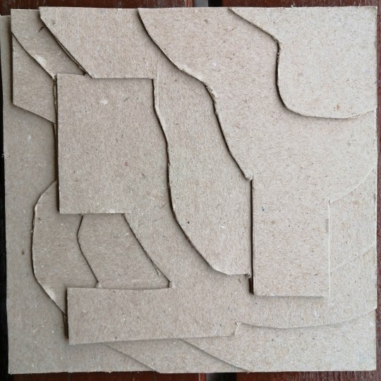
Assignment #2 Half & Half
Conceptual drawings / model / design idea etc. on 21cm.x21cm canvas for our A1 entrance design. We made an abstraction to reflect your early understanding of the subject and developed our conceptual drawings on the computer.
Inference:My abstraction remained too linear. It should have been with geometrical figures.I should also improve my conceptual drawing, especially drawing is still at the primary school level.
0 notes
Photo
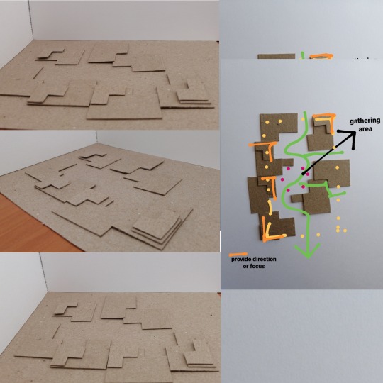
Half and Half Project: Conceptual Drawings
We started the period by correcting our conceptual drawings. This is the clearest and easiest way to explain ourselves. We created the hand and computer drawing of the conceptual drawing of ourA1 entrance homework. Unfortunately I'm not very good at this. I'm trying to understand concept and improve my dexterity.
0 notes
Photo
THE CITY SERIES 3 :EPHESUS
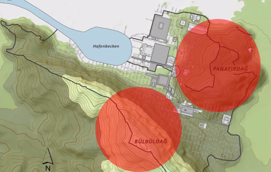
The member of the Department of Historical Archaeology Austrian Archaeological Institue, Dr. Martin Steskal, spoke about Ephesus’s research history, history of the Ephesus, and urban development in Ephesus. He started to talk about Ephesus and its history. Ephesus was the capital of the Roman Empire which is located between Panayır Mountain and Bülbül Mountain. Also, having many nations, different religious and ethnic origins, Ephesus has become an important place in history.
Ephesus was a city that changed as the relationship between geology and ecology changed. The most effective change was the disconnection of Ephesus from the sea by sedimentation and erosion. This change was a problem for its economy because the city economy was trade-oriented, and trade depended on the port, which was the center of the link. Small settlements have shifted to the west to be minimally affected by these changes. The other solution,ıts disconnection from the sea created many economic problems, so in defiance of nature, an artificial harbor was built to protect the city's access to the sea. The artificial port required a lot of time and money. As the trade deteriorated, the economy weakened, the harbor works decreased, and the economy worsened in this vicious cycle. Thus, Ephesus ceased to be a strong city as before.
Ephesus was designed with a grid system according to the Temple of Artemisia. Thus, that area can use more effectively and regularly. Later, some areas were selected for public buildings, functions, and private lands (later facilities). Many investments from trade and politics were used to build public facilities and water infrastructure or public fountains. Most of these public buildings were built in Roman times and aimed to provide sociality and economic development to Ephesus.
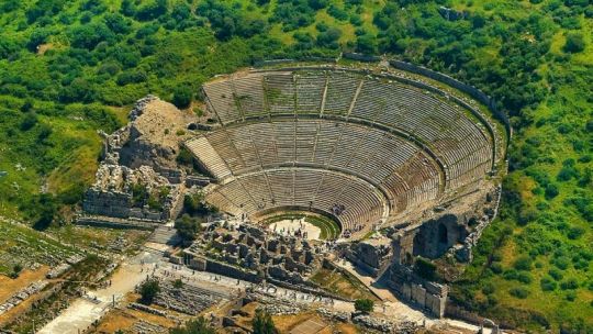
Martin talked about the important structures in Ephesus some of them: The Great Theater of Ephesus is one of the most important structures in the city. It is the heart of the city thanks to its architecture integrated into nature, its connection with the port, and other structures. Ephesus has undergone many changes (since the Hellenistic Period). Its structure has turned into many functions and areas of use as competitions, animal hunting, and parkland. It can accommodate approximately 25,000 people. Even the most developed cities today have large multi-purpose open spaces for human use. This theater is proof of how culturally developed this city is. We talked about Terrace Houses. These houses consisted of six units with equal parcels. They were the living quarters of the wealthy people in the city, with rich furniture and craftsmanship. They were houses that were designed far ahead of their time, heated from the floor of the house.
Curetes Street crosses the grid system and connects different parts of the city. This critical link and (marble without payment) structure turned this place into a boulevard. Baths and gyms in Ephesus were close to the city entrances to protect the city from disease by providing good hygiene with warm, cold, or freshwater for large groups. Reaching the water and making good use of it was one of the greatest wealth and awareness of this city. They made a life connected and influenced by water.
The uses in public areas in the city center have changed and transformed over time. Individuals reused timeless spatial spaces according to the needs of the period. The survival of the city has adapted to these changes. Unfortunately, the withdrawal of water caused the city to lose its importance. As resource consumption increased with the artificial port project and deforestation, the city could not cope with time and turned into an ancient city. Today, in order to protect the region, small settlements have been created in the Ayasoluk region, which is a flat area, and today's Selçuk region has been created in order to reach agriculture and resources.
Dr.Martin told us a lot about the city's design, development, change and struggle with time. Before that, I was going through an order-oriented design process that I set up on the grid system and the structures are given to us. I was still obsessed with the design looking good as in basic design. But the real world did not have a complete counterpart. What mattered was the function and the human movement. It was the connection that Ephesus was able to establish with the water and topography that made it a great city in its time. As it lost its connection with water, it lost its importance, so I realized that in order for me to create a city that is timeless and resistant to conditions, I first need to give importance to water and topography.
I want to end my article with the word of Heraclitus:’’Everything flows, nothing is permanent, so it is not possible to enter the same river twice; Because when I entered the river once more, both I and the stream have changed.’’ In brief,people, cities and possibilities change. What matters is how much we can adapt to change. This is what makes us permanent and successful.
0 notes
Photo
OPENING TALK: VISUAL ARTS AND DESIGN FROM THE PERSPECTIVE OF A VISION SCIENTIST BY INCI AYHAN
In the Opening Talk of this term, the chair of the Cognitive Science Program in Boğaziçi University Dr. İnci Ayhan discussed visual arts, design and perception from the perspective of a vision scientist.
Firstly, we mentioned that perception is not passive and gains meaning by being shaped by memories and information. In real life, there are no lines, but we can tell the truth with them because lines show us the perception of dimension, contrast, and depth. Images acquire meaning by passing through an infinite number of perspectives and scales of variability. For example, we can think that the vetch is a woman with fold drawings. It does not give us directions to a woman, but by completing the gaps between those curves from our perspective, we realize that that figure is a woman. İnci hoca said she admired the artists very much because they not only tell us their ideas but also enable us to see a huge world in our works with simple lines and simplified expressions. They are addressing human perception and psychology, trying to predict how we will shape them with our perceptions. Then we discussed the concepts of reality and abstraction.While we limit our imagination by showing everything clearly in reality but abstract works, we have to imagine by putting the parts about the whole. Thus, the rooted information begins to mean more to us. Finally, we talked about the way our eyes and mind perceive reality. People group information such as depth and contrast in a hierarchical order and make them meaningful. Gestalt psychology helps us here.
İnci Hoca answered many of my questions from her last semester.We also design things in our minds and try to explain them in abstraction. Even though I sometimes have good ideas,but it does not mean anything to other people because we cannot abstract them successfully.
0 notes
Photo
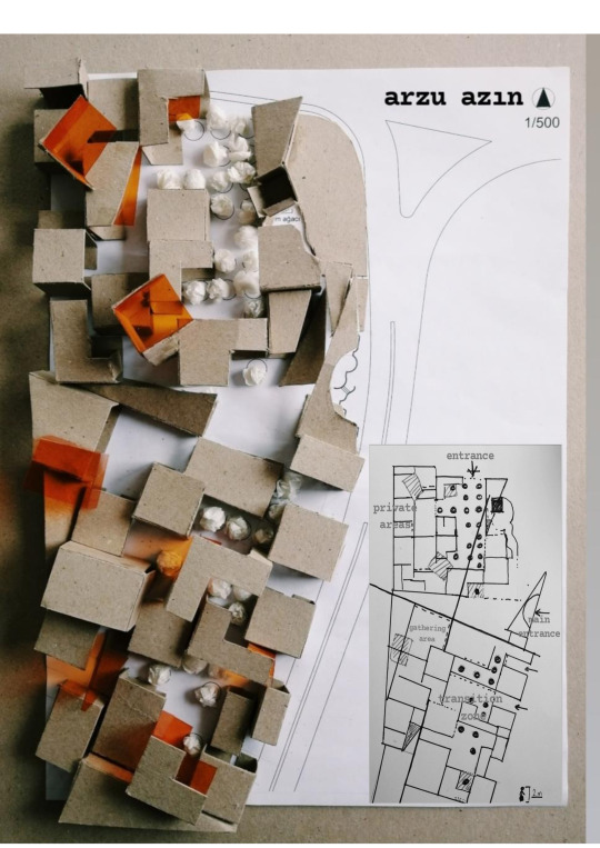
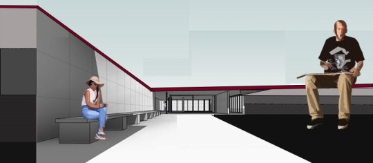
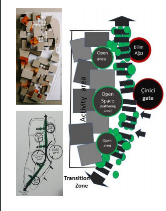
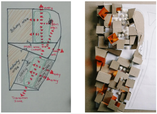
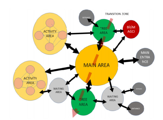
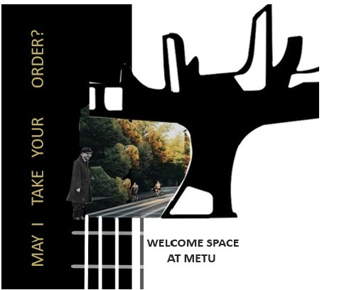
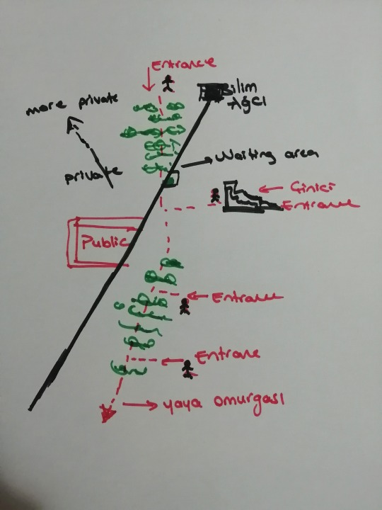
May I Take Your Order? A Welcome Space at METU
While I was planning, my focus point was Çinici Gate, Bilim Ağcı and trees, and the place was formed on these. I wanted to use the trees actively. While using their bottom as the transition zone, I connected four entries on this pedestrian spine. I thought of tree surroundings as activity-oriented areas that became privatized as I moved away from them. I have made the spatial transition easy to trees as much as the importance I give to the public area, and thought the trees and the public area more publicly. I used my powerlines to emphasize Bilim Ağcı and Çinici Gate.
0 notes
Photo
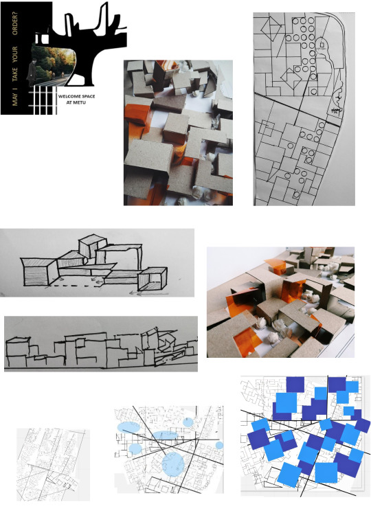
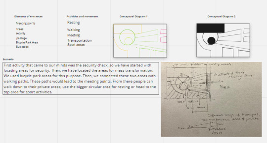
Scenario: Welcome SpaceAssignment
Entrance allows us to enter a new space. They are important places that first meet people entering the space and direct their movements. Metu special place that was considered with everything including green space, faculty buildings, and pedestrian paths.Her entrance was also special. When we enter Odtü we firstly meet the Bilim Ağcı. Then you pass through Çinici Gate and pass to a completely different place in the middle of the steppe. For the first time in the world, I feel completely belonging somewhere. Now I am in a completely different world with its trees, architecture, and people. some places have a soul and you see that spirit with your eyes and breathe it into your lungs. While planning this place, I wanted to add something to nature, not to steal from it. My space to be formed around the Çinici Gate,Bilim Ağcı and trees. I thought that people to spend time comfortably at the entrance, they can wait, walk comfortably, listen to music and feel at home.
0 notes
Photo
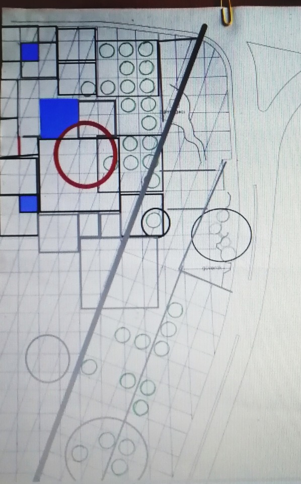
Inclass Exercise_From ideas to space
In inclass, we discussed what the entry place concept is, how an entrance should be, how to switch from public to private, and the impact of the entrance on them, and we chose odtü a1 and tried to abstract as a group. We thought about how this space will provide opportunities and how space is formed under their influence accordingly.
0 notes
Photo
Building Cluster
Exterior space is created when two or more buildings are clustered together.
These areas zoom in and out, creating spatial leaks .
If these clusters create larger and open spaces, these areas are called dominant open spaces.closed corners create a srong sense of spatial enclosure.
They determine the movement flow of the creature with the this areas.
0 notes