#virgin hemlock trail
Text


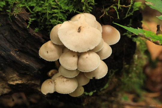
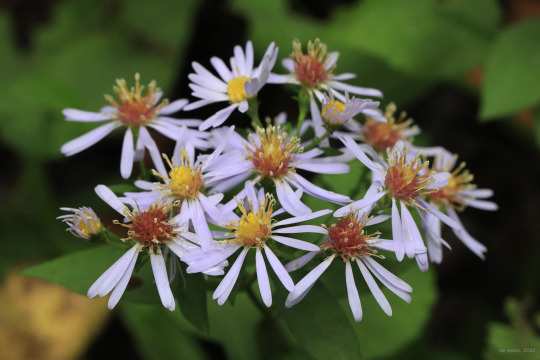
Dreary weekend in NC-WV, but once I got over my hangover from the WVU-Texas Tech game this morning, I managed to sneak in a quick fall hike on the Virgin Hemlock Trail in Coopers Rock State Forest. The asters are out in force and quite beautiful this fall. Among them are (from top): purplestem aster (Symphyotrichum puniceum); frost aster (Symphyotrichum pilosum), also known as awl aster; calico aster (Symphyotrichum lateriflorum); and blue wood aster (Symphyotrichum cordifolium).
#appalachia#vandalia#west virginia#wildflowers#flora#fall#coopers rock state forest#virgin hemlock trail#little laurel run#fungi#purplestem aster#purple-stemmed aster#frost aster#awl aster#hairy white oldfield aster#calico aster#blue wood aster#canada goldenrod#partridge berry#partridgeberry#common puffball
124 notes
·
View notes
Text
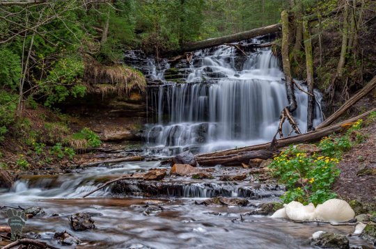
Waterfall Wednesday at Wagner Falls
Waterfall Wednesday at Wagner Falls
Wagner Falls and Marsh Marigolds by Footsore Photography
Pure Michigan shares that the Wagner Falls Scenic Site near Munising:
…is nestled amongst virgin pine and hemlock trees. There is a small parking area and a half-mile trail with an observation deck overlooking the falls. Wagner Creek falls over a stratum of erosion-resistant dolomite into order to flow into a shallow gorge containing the…

View On WordPress
4 notes
·
View notes
Text
Waterfall Wednesday at Wagner Falls
Waterfall Wednesday at Wagner Falls
Wagner Falls and Marsh Marigolds by Footsore Photography
Pure Michigan shares that the Wagner Falls Scenic Site near Munising:
…is nestled amongst virgin pine and hemlock trees. There is a small parking area and a half-mile trail with an observation deck overlooking the falls. Wagner Creek falls over a stratum of erosion-resistant dolomite into order to flow into a shallow gorge containing the…
View On WordPress
0 notes
Text
Part I

Masterlist
Part II
It was almost 2 in the morning and Y/N was incredibly intoxicated, all thanks to her best friend, Roman Godfrey, who had convinced her to go out to unwind from another stressful week at work.
Y/N’s relationship with Roman began innocently enough. Her father had worked at the Godfrey Institute for the majority of Y/N’s childhood so Roman and her had pretty much grown up with each other. They got along well enough as kids until they reached that age where boys and girls being friends was simply unacceptable to their peer groups, but eventually reconnected the summer before they were to enter high school.
The pair had been dragged by their parents to another boring White Tower function and were the only two people there who were even moderately near their age. After managing to sneak a couple bottles of champagne the two teens found an empty room and played a game of truth or dare. During this activity it was discovered that they were both virgins. What started out as a dare for Y/N to kiss Roman led to the two deciding that they might as well lose their virginities to each other so they - according to Roman - “wouldn’t seem like complete fucking tools” when they wanted to have sex with someone who mattered.
From that night forward, Y/N and Roman had been regularly hooking up. It was nothing more than non-exclusive, emotionless sex.
The two had also become close friends; it was nothing compared to Roman’s relationship with Peter, but on more than one occasion he had shown up at YN’s house bitching about his problems only to take out his frustrations on her in all the best ways possible.
After Letha had died and Peter left, it was Y/N that Roman turned to and even though it broke her heart to see Roman that way, she was also infatuated by his new-found vulnerability. Though she could tell that there were things he was hiding from her, for whatever reason, she knew Roman better than to push his boundaries. At first Roman had been so clingy and needy it made Y/N want to kill him but eventually she grew to like it. The problem now, her current problem, was that she had begun to like it too much.
Y/N never had a thing for overly affectionate, emotional, romantic guys before, that’s why Roman was so great. He would make her cum and then leave her alone until the next time he made her cum. They also had rules that made their system work so well. They could kiss, flirt, and sleep over at each other’s places only when they would have sex.
Their system worked perfectly until Roman became dependent on her. He would often spend the night at her place and cuddle and kiss her throughout the day without trying to push for more. He had even begun kissing her at at the top of her head and playing with her hair whenever they would lay down together.
Y/N was conflicted. On one hand, she didn’t want to say anything to Roman while his abandonment wounds were still so fresh but on the other, she knew that them acting like this could only lead to trouble. Her contemplation over what to do was eventually realized to be pointless about a week ago when Roman had just finished giving her the best back rub anyone had ever received. If someone had heard her moaning, they would’ve thought that she had had 10 orgasms by now.
“Thank you” Y/N said, almost breathlessly, as she crawled over into bed beside Roman.
“Anytime baby” he replied with a wink while grabbing his phone to look through work emails.
“baby”
It just took that one stupid little word being said to make Y/N realize just how smitten she really was with him. Once she heard Roman call her that she instantly knew she never wanted him to call her anything else ever again.
Logically, Y/N knew that he didn’t mean anything by it.
“baby”
She was infatuated - not delusional, but something about the way it sounded coming out of his mouth made her want to wrap herself around the tall man in her bed and never let go.
Since then, Y/N had tried to think about what she should do about her feelings:
Tell him? -No, that would be dumb
“baby”
Avoid him? - Doubtful that Roman would let me go a full 24 hours without contact
“baby”
Run away? - It’s Roman Godfrey, he would have a security team tracking me before I could even finish packing
“baby”
brain fuck off
“baby”
Shoot myself? -maybe
Luckily for her, Roman had been especially busy with work this week so the only time she really saw him was when he needed to get laid. The downside to this was that it gave her more time to ruminate over her current situation. Y/N had decided that her best course of action was to just ignore it. Push it down until it went away or exploded, but that was future Y/N’s problem.
The bar Roman had dragged her to was old and grimy - like most places in Hemlock Grove. The bar table they were sitting at was sticky and reeked of alcohol but Y/N was too drunk to care. Considering Y/N’s tendency to become overly affectionate whenever she drank, she figured it would allow her to indulge her fantasies somewhat without striking up any suspicion.
Roman was too busy ranting on about how his idiot receptionist had managed to fuck up something simple yet again to notice just how intoxicated she was until she got up from her bar stool to stand in-between his legs and wrap her arms around his shoulders. Roman paused mid rant, put his arms around her waist and looked at her with a raised brow. Y/N smiled, used her finger to slightly tilt his head up and kissed him soft and slowly. Roman quickly took control by biting her lip before slipping his tongue into her mouth and pulling her closer into him. Y/N moved her hands from his shoulders into his hair and tugged softly before they broke apart. Once they caught their breaths, before Roman could say anything, Y/N grabbed his chin between her thumb and forefinger, bringing him back to kiss her again while the other hand trailed down Roman’s chest to his belt buckle and gently rubbed his groin. Just as she felt it begin to twitch, she abruptly pulled away and looked at him with a shit-eating grin plastered on her face. Roman snapped back to reality and glared at her.
“You’re such a fucking tease when you’re drunk” he muttered
“Ya? well what are you going to do about it?” she said coyly, biting her lip while running her fingers up and down his chest.
Roman grabbed her hips and twisted her around roughly so her back was flat against his chest
“I’m gonna go take a piss but when I come back I’m taking you home and fucking you so deep into the mattress, you won’t be able to find your way out for a week” he growled into her ear.
“Promise?” She asked.
Instead of responding, he kissed the base of her neck quickly in confirmation before standing her up and excusing himself to the restroom.
****
Hey guys! This is the beginning of a multi part fic I’m writing. It will probably be around 4 parts or so. If anyone wants to be tagged in future parts just let me know and if you have any thoughts, questions or requests for imagines, prompts, drabbles, etc for bill or his characters feel free to send them in! :)
****
@ill-skillsgard
#Roman Godfrey#roman godfrey gif#romangodfrey#roman godfrey imagine#roman godfrey imagines#roman godfrey x reader#hemlock grove#hemlock grove imagine#Bill Skarsgård#bill skarsgard
156 notes
·
View notes
Photo
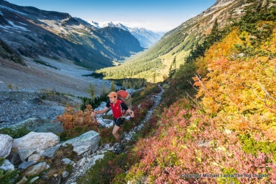
By Michael Lanza
The imminent end of summer always feels a little melancholy. After all, it marks the close of the prime season for getting into the mountains. But it also signals the beginning of a time of year when many mountain ranges become less crowded just as they’re hitting a sweet zone in terms of temperatures, the lack of bugs, and fall foliage color. Autumn also stands out as an ideal season for many canyon hikes, with moderate temperatures and even some stunning color.
From Yosemite to the North Cascades (lead photo, above), Grand Canyon to Grand Teton, the Great Smokies to the Olympics, and more, here are 10 of my favorite backpacking trips that are best served up in fall.
Todd Arndt backpacking over Park Creek Pass, North Cascades National Park.
No. 1 North Cascades National Park
In the last week of September, with huckleberries ripe and tasty and the larch trees blazing yellow with fall color (lead photo at top of story), a friend and I took an 80-mile hike through the heart of the North Cascades National Park Complex, a sprawling swath of heavily glaciated mountains and thickly forested valleys. Our grand tour from Easy Pass Trailhead to Bridge Creek Trailhead took us through virgin forests of giant cedars, hemlocks, and Douglas firs, and over four passes, including Park Creek Pass, where waterfalls and glaciers pour off cliffs and jagged, snowy peaks.
We enjoyed five sunny, glorious early-fall days; but, of course, snow can fall in these mountains in September, so watch the forecast. The good news: It’s easy to get a backcountry permit—no reservation needed in most of the park. North Cascades has long been one of my favorite parks (it has one of the most inspiring backcountry campsites I’ve ever slept in). But not many backpackers know this place: It’s one of America’s least-visited national parks. That’s good if you like solitude.
See my story “Primal Wild: Backpacking 80 Miles Through the North Cascades,” which also describes shorter variations of the 80-mile route.
Read about how climate change is affecting the North Cascades and other parks in my book
Before They’re Gone—A Family’s Year-Long Quest to Explore America’s Most Endangered National Parks.
David Ports hiking the Tonto Trail in Salt Creek Canyon, Grand Canyon National Park.
No. 2 Grand Canyon National Park
You already know that spring and fall are the prime seasons for backpacking in the Grand Canyon. But while weather can be unstable in either season, in spring you’re aiming for a window between when snow and ice melt off the rims in April and when the scorching temps hit the inner canyon in May. In fall, though, you’ll enjoy dry trails, a surprising amount of color in the sparse desert vegetation, and pleasant temperatures often lasting into November (which was when I backpacked there with my daughter).
Backpacking permits for the corridor trails—the South and North Kaibab and Bright Angel—are in high demand. Sure, grab those campsites if available; but if not, I recommend the 29-mile hike from Grandview Point to the South Kaibab Trailhead, or the 25-mile hike from Hermits Rest to the Bright Angel Trailhead—or even combining or overlapping them. Both feature sublime campsites, stretches of flatter hiking along the Tonto Trail with views reaching from the Colorado River to the South and North rims, and crossings of deep side canyons with flaming-red walls shooting straight up hundreds of feet.
See my stories “Dropping Into the Grand Canyon: A Four-Day Hike From Grandview Point to the South Kaibab Trail,” and “One Extraordinary Day: A 25-Mile Dayhike in the Grand Canyon” (photo above); my stories about two full-value Grand Canyon adventures, backpacking the Royal Arch Loop off the South Rim and the Thunder River-Deer Creek Loop off the North Rim; and all of my stories about South Rim backpacking trips.
Show up and hike. See my story “How to Get a Last-Minute, National Park Backcountry Permit.”
Noland Creek in Great Smoky Mountains National Park.
No. 3 Great Smoky Mountains National Park
Unquestionably one of the East’s premier backpacking destinations, the Great Smokies have two peak seasons: spring, when about 1,600 species of flowering plants—more than found in any other national park—come into bloom; and fall, when dry air and moderate temperatures settle in, insects have mostly disappeared, and the forest paints itself in the brilliant hues of autumn foliage. While you’ve probably seen many photos of the classic vistas from Great Smokies summits of overlapping rows of blue, wooded ridges fading to a distant horizon, I’ve found that much of the park’s magic resides in its rocky streams tumbling through cascades, and a diverse forest where you may hear only the sound of birds.
On a 34-mile, October hike in the park, beginning near Fontana Lake and traversing a stretch of the Appalachian Trail, I enjoyed a grand tour of this half-million-acre park, including 6,643-foot Clingmans Dome and the park’s highest bald, 5,920-foot Andrews Bald. I also found a surprising degree of solitude, even in the very popular fall hiking season.
See my feature story about that trip, “In the Garden of Eden: Backpacking the Great Smoky Mountains,” and all my stories about Great Smoky Mountains National Park and hiking and backpacking in western North Carolina.
Hi, I’m Michael Lanza, creator of The Big Outside, which has made several top outdoors blog lists. Click here to sign up for my FREE email newsletter. Subscribe now to get full access to all of my blog’s stories. Click here to learn how I can help you plan your next trip. Please follow my adventures on Facebook, Twitter, Instagram, and Youtube.
Mark Fenton above the Lyell Fork of Merced River Canyon, Yosemite National Park.
No. 4 Yosemite National Park
Want to know the hardest thing about backpacking in Yosemite? Getting the permit. Well, okay, the hiking itself can be tough at times. But the competition for backcountry permits in this flagship park is stiff, especially for popular trailheads in and around Yosemite Valley and Tuolumne Meadows. That’s why backpackers in the know go after Labor Day. While early-season snowstorms occasionally slam the High Sierra in autumn, nice weather often lingers through September and well into October—my favorite time in the High Sierra.
With the population pressure eased up in late summer and autumn, you can often score a walk-in permit—without a reservation—for a five-star hike of almost any distance, hitting top Yosemite summits like Clouds Rest and Mount Hoffmann, and the incomparable Grand Canyon of the Tuolumne River, plus remoter areas like Red Peak Pass, the highest pass reached by trail in Yosemite. Then the only hard aspect of the hike will be… yea, the hike.
See my stories “Best of Yosemite, Part 1: Backpacking South of Tuolumne Meadows,” “Best of Yosemite, Part 2: Backpacking Remote Northern Yosemite,” “Ask Me: Where to Backpack First Time in Yosemite,” and “Ask Me: Where Can I Hike in Yosemite in Late Fall?” and all of my stories about Yosemite National Park and California national parks at The Big Outside.
Plan your next great backpacking trip in Yosemite, Grand Teton, and other parks using my expert e-guides.
A backpacker at Toleak Point, Olympic National Park.
No. 5 Olympic National Park Coast
The longest stretch of wilderness coastline in the contiguous United States—the 73-mile strip of Olympic National Park hugging the Pacific—preserves one of America’s most unique and scenic backpacking trips. And the Pacific Northwest’s typically glorious summer weather can last into October, when temperatures remain moderate on the coast. With a weather window of two to three days, you can knock off a section of the coast.
The northern coast attracts more backpackers and dayhikers, but the 17.5-mile, two- to three-day hike along the southern coast, from the Hoh River north to La Push Road, features similar scenery and fewer people. And what a hike it is: giant trees in one of Earth’s largest virgin temperature rainforests; sea stacks rising up to 200 feet out of the ocean; boulders wallpapered with sea stars, mussels, and sea anemones; sightings of seals, sea otters, whales; and rugged (and sometimes muddy) hiking on overland trails, with rope ladders to climb and descend very steep terrain.
See my story “The Wildest Shore: Backpacking the Southern Olympic Coast.”
Want to read any story linked here? Get full access to ALL stories at The Big Outside, plus a FREE e-guide. Subscribe now!
Backpackers and wildflowers, Death Canyon Shelf, Grand Teton National Park.
No. 6 Grand Teton National Park
Like Yosemite and Grand Canyon, Grand Teton is a park where securing a backcountry permit reservation requires being on top of the process months in advance; after May 15, no reservations are accepted for the rest of the year, and only walk-in permits are issued, up to a day in advance of a multi-day hike. But the park also sets aside about two-thirds of available campsites for walk-ins. While demand is huge for those during July and August, as with other parks, it tails off steadily after Labor Day.
The combination of relatively high elevations and a northerly latitude brings a slightly higher probability that snow will fly in the Tetons in late summer or early fall. But beautiful summer weather, with pleasant days and crisp nights, can extend into late September and even October, a season when you’ll see aspens turn golden and hear rutting elk bugling. And few backpackers show up at park offices seeking a permit—you can walk in, grab one, and go.
See my stories “American Classic: The Teton Crest Trail” and “Walking Familiar Ground: Reliving Old Memories and Making New Ones on the Teton Crest Trail,” and all of my Ask Me posts about Grand Teton National Park.
I’ve helped many readers plan an unforgettable backpacking trip on the Teton Crest Trail.
Want my help with yours? Find out more here.
My family backpacking in Chimney Rock Canyon, Capitol Reef National Park.
No. 7 Capitol Reef National Park
Spring and fall are the seasons to backpack in the desert Southwest, mostly because the blazing heat of summer has dialed back to a temperature range that humans can survive. In Capitol Reef, with its somewhat higher and cooler elevations, the fall hiking season stretches from early September well into November. And consider this fact: While many of the Southwest’s best backpacking trips require applying for a permit months in advance, so few people backpack in Capitol Reef that you can show up at the visitor center’s backcountry desk, grab a free permit for a multi-day hike, and hit the trail immediately—no reservation needed.
And Capitol Reef’s soaring red cliffs and white beehive formations, broad river canyons and narrow slots certainly compete with southern Utah’s four other national parks in the splendor department. I’ve backpacked with my family in Spring Canyon—where easy hiking and water availability were much appreciated with young kids—done an overnight camping on the rim above Upper Muley Twist Canyon, and made a stunningly beautiful and adventurous, mostly off-trail, three-day traverse of the park’s signature feature, the topographical maze of cliffs and canyons known as the Waterpocket Fold.
See my stories “The 5 Southwest Backpacking Trips You Should Do First,” “Plunging Into Solitude: Dayhiking, Slot Canyoneering, and Backpacking in Capitol Reef,” “Ask Me: Where Should We Backpack in Capitol Reef National Park,” and “The Most Beautiful Hike You’ve Never Heard Of: Crossing Utah’s Capitol Reef,” plus all of my stories about Capitol Reef National Park and hiking and backpacking in southern Utah at The Big Outside.
Find your next adventure in your Inbox. Sign up for my FREE email newsletter now.
Mark Fenton at Zeacliff, overlooking the Pemigewasset Wilderness, White Mountains, N.H.
No. 8 White Mountains
If ever there were mountains that screamed to be explored in fall, these are those. New Hampshire’s rocky and steep White Mountains are where I wore out my first several pairs of hiking boots, and I still return every year for their awe-inspiring brand of suffering. While the fall colors that usually peak in early October are beautiful throughout the Whites, my top two picks for fall backpacking trips are a 32-mile loop around the Pemigewasset Wilderness and a 24-mile traverse from Crawford Notch to Franconia Notch, mostly on the Appalachian Trail.
The 32-mile Pemi Loop from the Lincoln Woods Trailhead on the Kancamagus Highway (NH 112) crosses eight official 4,000-foot summits, including the alpine traverse of Franconia Ridge—with its constant panorama encompassing most of the Whites—and a walk along the rocky crest of remote Bondcliff, in the heart of the Pemigewasset. Crawford to Franconia overlaps some of the Pemi Loop’s highlights, while adding killer views of Crawford and Zealand notches. (Tip: Definitely take the short side trip to the overlook at Zeacliff, photo above.) And you can add on the summits of Bond, Bondcliff, and West Bond by tacking on an out-and-back side trip that adds several miles.
See my stories “Still Crazy After All These Years: Hiking in the White Mountains,” “Being Stupid With Friends: A 32-Mile Dayhike in the White Mountains,” about dayhiking the Pemi Loop, and “Ask Me: What Are Your Favorite New England Hikes?”
Be comfortable on your hikes. See my review of “The 5 Best Rain Jackets For the Backcountry.”
Jeff Wilhelm backpacking Gnarl Ridge on the Timberline Trail, Mount Hood.
No. 9 Mount Hood’s Timberline Trail
A multi-day hike with views around almost every bend of a towering volcano draped in snow and ice, where you pass through forests of ancient, big trees—sounds like the classic Wonderland Trail around Mount Rainier, right? Actually, it’s the 41-mile Timberline Trail looping Oregon’s 11,239-foot Mount Hood, and it competes with the better-known Wonderland for scenic splendor, waterfalls, and wildflower meadows, while delivering a higher degree of excitement and challenge with its full-value creek crossings. Although the wildflowers are obviously past bloom in fall, the creek crossings become reassuringly easier, the crowds thinner, the air crisper, and the views no less stunning.
Granted, the year’s first snowfall can certainly happen at Hood in September or October. That said, autumn delivers many days of glorious weather in the Pacific Northwest, and the Timberline is less than half the distance of the Wonderland, making it easier to knock off with a decent weather window. (Plus, unlike the Wonderland, the Timberline involves no permit hoops to jump through.) If the forecast promises a string of three to five reasonably nice days, aim your compass for the Timberline Trail.
See my story “Full of Surprises: Backpacking Mount Hood’s Timberline Trail.”
Time for a better backpack? See my picks for “The 10 Best Backpacking Packs”
and the best thru-hiking pack.
Great Sand Dunes National Park & Preserve, Colorado.
No. 10 Great Sand Dunes National Park & Preserve
Not many natural features produce their own kind of music. But that’s exactly what happens when you walk along the crest of giant sand dunes—which are often as narrow as the peak of a roof, or barely the width of your boot: Sand cascades down the dune’s very steep sides, creating squeaking and booming sounds described as “singing.” If that’s not magical enough, the night sky riddled with stars and the vivid colors of the dunes—exaggerated in morning light—make this one of the most unique backpacking trips in the country.
Too hot throughout summer—and absolutely waterless, meaning you have to carry all you’ll for an overnight exploration—Great Sand Dunes National Park & Preserve is best in spring or fall. November brings pleasant days and often a frost that sparkles on the frozen sand in early morning.
See my story “Exploring America’s Big Sandbox: Colorado’s Great Sand Dunes.”
Tell me what you think.
I spent a lot of time writing this story, so if you enjoyed it, please consider giving it a share using one of the buttons below, and leave a comment or question at the bottom of this story. I’d really appreciate it.
Feeling inspired by this story? Subscribe now for full access to ALL stories at The Big Outside and get a free e-guide!
0 notes
Photo
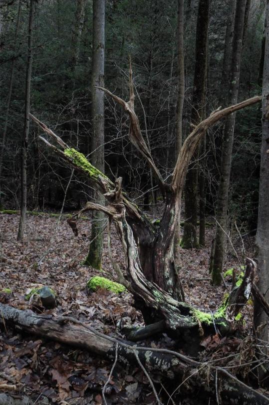
This old tree stump makes this place feel devilish. Virgin Hemlock Trail- WVU Research Forest -Preston County, West Virginia. [1280x1980][OC] via /r/EarthPorn http://bit.ly/2CTTFB0
0 notes
Photo
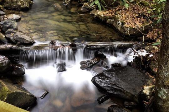
Lick Run- Virgin Hemlock Trail, Preston County West Virginia. [1920x1280][OC] Long Exposure Music
0 notes
Photo
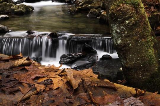
Falls leaves. Virgin Hemlock Trail- WVU Research Forest. Preston County, West Virginia. [1920x1280] [OC]
0 notes
Text
Snow Figures
The snow lacks sincerity, but snowmen rummage the village anyway, scouring for decorative trinkets to cover their nakedness. If you look into the glitter of their anthracite eyes you doom yourself to follow their scuff-marks into the forest at the edge of town. There in the hush of evergreens even the faintest word rings like struck metal. You would lose all reason and gibber in colors no sunset could endorse. Crystals would clatter from the hemlocks, and the snowmen would thrust forth impossible tongues to devour the air. If you saw that happening you would go mad. You would believe that the snowmen mean what they say although they never speak. You would believe that the scuff-trails they’ve left all over the village and into the forest form the handwriting that drove biblical kings to war and self-destruction. You would mistake the evergreens for skyscrapers in the desert, where famous paintings sold at auction go to die. If you escaped the forest with your intellectual virginity intact no one would believe you saw the snowmen wheeling about like grocery carts. Although everyone in the village has built a snowman according to cosmic instructions, although everyone has seen his or her snowman shuffle away under its own power, all have sworn to keep this animation secret.
0 notes
Text
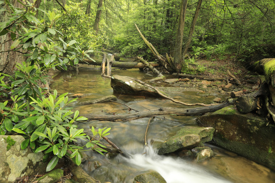
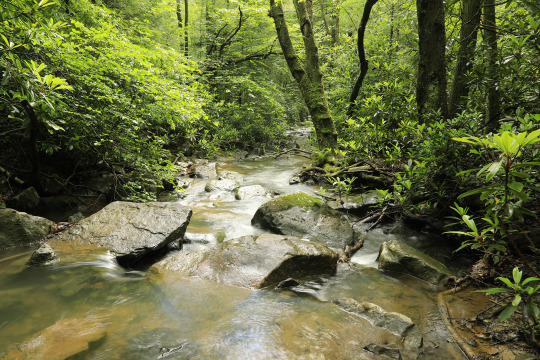
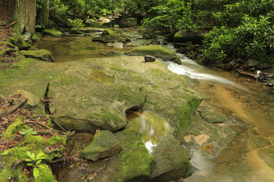
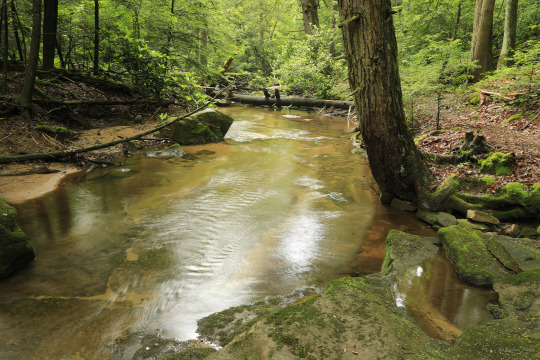


“A rainy day is the perfect time for a walk in the woods.”
— Rachel Carson
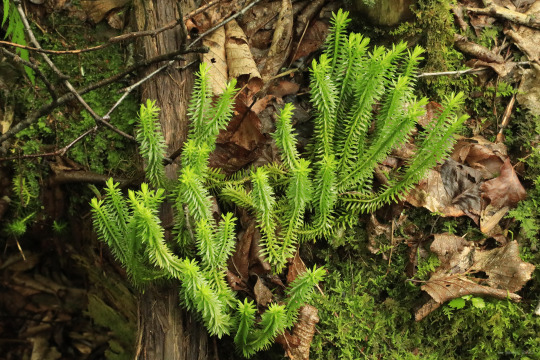
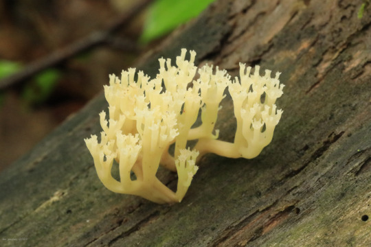
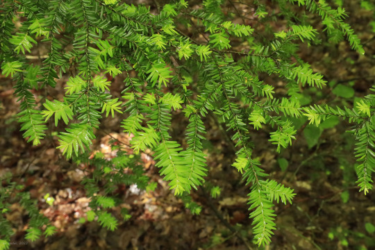
The photos above were taken along the Virgin Hemlock Trail at Coopers Rock State Forest following a prolonged rain. The old forest's dripping green intensity, charged by early summer's electric, stormy atmosphere, reminds us that nothing really dies here; all matter is reabsorbed and repurposed and made new again. You can smell it in the wet moss, decaying wood, and humus. The forest is immortal and sentient and relentlessly renewing itself.
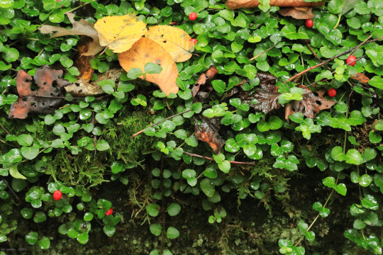
From top: Little Laurel Run rushing through the old hemlock forest like a gem-filled artery; partrideberry (Mitchella repens), a trailing, evergreen vine whose fragrant white flowers come in pairs; a tall, handsome whorled loosestrife (Lysimachia quadrifolia) in bloom at the forest's edge; white avens (Geum canadense), a shade-tolerant perennial of forest margins; swamp dewberry (Rubus hispidus), a bristly-stemmed relative of the blackberry; wild hydrangea (Hydrangea arborescens), also known as smooth hydrangea, a rapidly-colonizing woodland shrub with high wildlife value; running clubmoss (Lycopodium clavatum), an attractive, spore-bearing vascular plant; crown-tipped coral (Artomyces pyxidatus), an elegant, edible coral fungus that grows on decaying wood; and eastern hemlock (Tsuga canadensis), the forest's majestic benefactor, which can grow to over 100 feet high and live to be more than five hundred years old.
#appalachia#vandalia#west virginia#wildflowers#coopers rock state forest#little laurel run#virgin hemlock forest#virgin hemlock trail#old growth forest#rain#eastern hemlock#partridgeberry#whorled loosestrife#white avens#swamp dewberry#wild hydrangea#smooth hydrangea#running clubmoss#crown-tipped coral#early summer
76 notes
·
View notes
Photo
New Post has been published on https://www.indiatourblog.com/sandakphu/
Adventurous trek of Sandakphu : Singalila national park
Sandakphu
Sandakphu Trek
Darjeeling the world over acclaimed as one of the exceptional hill accommodations is likewise a veritable paradise for trekkers and adventure seekers. Trekking in Darjeeling is an revel in which no lover of nature ought to leave out. It takes one to locations in which nature is but in her premival majesty. It brings one face to face with the chic grandeur of the Himalayas.
The location abounds in rhododendrons,magnolias,primulas,orchids and ferns of several varieties. About 600 one of a kind species of birds inhabit the emerald green forests at the slopes of the mountains. The subsequent is a short description of a number of the maximum popular and maximum profitable treks in the location sandakphu.
Route No – 1(a)
This trek is possibly one of the satisfactory and really the most popular of all of the treks in Darjeeling for those having a restrained time at their disposal. It offers the travelers an top notch view of the Kanchenjunga and the Everest institution of mountain peaks in Nepal, Sikkim and Bhutan.
It is really useful to start the trek early in the day and to cover their distance from Darjeeling to Maneybhanjyang Approximately 26 km. with the aid of jeep/buses. One can also cross up-to Sukhiapokhri.
Halfway from Darjeeling given that transport thus far is without difficulty available and from right here to Maneybhanjyang either through jeep/buses or one can even trek from right here to Maneybhanjyang(four km). The power from Darjeeling to Sukhiapokhri is about one hour and from there to Maneybhanjyang some other 1/2 an hour.
Maneybhanjyang to Tonglu is a steep climb up to Meghma 7 km or 3.5 hrs. stroll. There is a small tea residence in which tea and snacks are available at reasonable price(if important, accommodation is also to be had at Meghma Tea house). Meghma is a small hamlet with few homes & small Monastery & stunning Chorten(stupa). Meghma to Tonglu is another 2 kms.
Route of Sandakphu
Tonglu or the local call Tumling is 3070 mt. excessive and is one in every of peaks of Singalila range, falls at the West of Darjeeling town. On a clean day it is easy to get a excellent view of the Nepalese valleys and of the plains of North Bengal with the snow fed Teesta at the east, the Koshi on the West and a number of smaller rivers between them. There is a Trekkers Hut at Tonglu.
Day after today’s march from Tonglu to Gairibas 2621 mt. Is downhill. The gap is nine km and It’s far 2 hrs. stroll. The Course passes via the bamboo glades. Gairibas to Kalipokhri 3170 mt. Is continuous climb via the rhododendron woodland. Distance is 6 km and it takes three hrs. walk from Gairibas. Trekkers may also prevent right here for a while for a tea wreck. There’s a small pond at Kalipokhri which means that ‘Blackpond’.
The colour of the water is black and muddy and it never freezes. From Kalipokhri the street descends to Bikhaybhanjyang-valley of poison-(Aconites grow in abundance at this place). Bikhaybhanjyang to Sandakphu is a steep climb of 4 kms. And takes extra than an hour to cover this trek. Accommodation is likewise available at Bikhaybhanjyang and Gairibas. There is a trekkers hut at Gairibas.
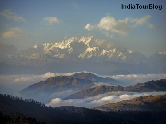
Sandakphu 3636 mtr. Is fifty eight km. From Darjeeling and instructions one of the most extraordinary views. in the foreground is a exquisite basin set inside the midst of the hills, the slopes blanketed with rhododendrons and silver fir bushes. inside the background is non-stop barrier of snowy mountains, the most distinguished of which is Kanchenjunga-28156 feet. 8598 mts. Towering up in gigantic peak and breadth with its attendant peaks Kabru 7338 mts. 24,026 feet, Jano (Kumbhakarna) 7710 mts. 25,294 toes. And Pandim 6691 mts. 22,010 toes. Clustering closely round it.
Kabru is foreshortened and does now not present the same graceful outline above the spectacle with its lofty height standing up like a notable icy horn. Some distance off to the west at a distance of one hundred sixty km. among-st a collection of different snowy mountain rising from graceful peaks of Everest institution can be visible,at the back of the crest of Mt. Makalu, which seems like a super armed chair of snow; and further to the west closer to Nepal, There is a awesome rectangular mass of mountain searching like a wall of snow Chamlang 7317m-24006 ft.
The comparison between Everest and Kanchenjunga may be very marked. Kanchenjunga is incredible for its imposing bulk and huge proportions while Everest soaring above a chain of valleys and its ridges, is more swish and majestic. The gap between the two is occupied by using snowy degrees.
Three Sisters which cluster collectively if you appearance toward east past Kanchenjunga you’ll see Narsing and then the Dongkya and Chola tiers of the Tibetan frontier with Chumalhari lifting up to its heads within the rear. The whole snowy degrees of Bhutan, Sikkim and Nepal About 320 kms in duration; is seen, however the panoroma is completely dominated by using the Kanchenjunga and Everest group.
Kanchenjunga-correctly spelt is Kanchenjunga is the third maximum mountain in the global way “Five Treasures of the incredible Snow” and is a dad or mum deity of the Sikkimese.
From the center of April til 1st week of June this location blushes with rhododendron bloom and spread with carpet of lovely primula and other alpine flora. Trekkers can stay at the Trekkers Hut in Sandakphu.
The return march to Maneybhanjyang may be executed both in an afternoon or two breaking journey both at Gairibas or Tonglu, relying on the bodily circumstance of the Trekkers and the time at his disposal. If the primary opportunity is selected, the journey have to begin today’s by way of 7 a.m. It takes About 8 hours of continuous march to Maneybhanjyang.
Rhododendron Flower
Route No – 1(b)
Upto Sandakphu is in route no – 1(a)
If the trekkers have sufficient time next day they are able to march similarly closer to Phalut 3600 mts. It is one of the loftiest peak inside the Singalila range is located eighty km. North West of Darjeeling city. The name Phalut is a corruption of the Lepcha word Falut or the peeled summit and appellation derived from the bare treeless slopes, which give a extremely good evaluation to the woodland clad tiers below. The peak is also called Phalilung through the local people.
The stretch from Sandakphu to Phalut is the maximum surprising of the trek. The burned silver-fir wooded area makes most stunning sight one will ever left come across. After strolling for a little while the trekker might be observed by way of the Everest institution on the left and Kanchenjunga variety right beforehand.
A stroll of Approximately 4.5 hrs. From Sandakphu the trekker will encounter a stone residence with blown of roof on the top of a small ridge. The vicinity is called Sabarkum and is 14 km. From Sandakphu. An opportunity place of stay is MOLLEY Trekkers Hut Approximately 2 K.M. From Sabarkum, for people who do not need to stroll to Phalut the equal day. Maintaining the ridge on the left observe the trail north ward. After Approximately an hour the path starts offevolved to climb thru a sequence of zigzag until one reaches Trekkers’ Hut. From right here Phalut summit is ready 20 minutes stroll.
A magnificent view of snowy range is received from the summit which is also junction of Sikkim, West Bengal and Nepal. The overall landscape is equal as visible from Sandakphu except that Kanchenjunga levels appears a great deal large and closer. It’s far simplest forty eight km. Away because the crow flies. The trekkers will also be aware on the foreground Singalila variety jutting out of Kanchenjunga top. There’s a Trekkers Hut at Phalut. Trekkers can camp at Molley 1,811 mts. Phalut is 1.5 hours walk from this point.
Darjeeling-Maneybhanjyang-Gairibas-Sandakphu-Phalut-Rammam-Rimbick one hundred thirty km(6 days) up-to Phalut as in Route – 1(a). From Phalut to Rammam threw are two routes i) thru Sabarkam ii) via Gorkhey-Samandin.
Route No – 2(a)
To absorb this Path, retrace again to Sabarkum and turn left of their roofless homes. This path passes thru the virgin wooded area which is steep down-hill to Rammam. This takes About 5 hrs. walk and 16 k.m In distance. From Phalut, the proper hand path cause Srikhola and climbs up to Daragaon and again descends to Rimbick. It takes About eight hrs. walk and 25 K.M. In distance from Phalut.
Observe : Do now not challenge this path all through winter i.E. November and March because it gets darkish by using 4 p.M. And can be difficult to find the way.
Route No – 2(b)
From Phalut the path descends the ridge through the virgin forests of chestnut, pines, hemlock etc. until the path reaches the assembly of streams known as Gorkhey Khola which is a tributary of Rammam river. It is a stunning place.
Trekkers can experience the bathtub inside the river after the annoying trek starts to climb up-to Samandian-a cute plateau and It’s far a small woodland village. From Samandin the road descends to a small move and once more climbs up for every other 1.five hrs. To Rammam Trekkers hut. This is About 5 hours stroll or 15 km. In distance from Phalut.
From Rammam the street is almost stage stroll for Approximately first nine km. And again it descends to Srikhola. the street rises steep, for Approximately 1 k.M. in which it levels out again until it reaches Rimbick. There’s a small bazaar at Rimbick. In case the Trekkers choice to return to Darjeeling by means of bus next day, It is advisable to stay at Rimbick bazaar.
Darjeeling-Rimbick-Sandakphu and again 123 kms. 4 days.
From Darjeeling to Rimbick everyday buses are to be had round 12.30 p.M. It’s far About five hrs. pressure and 54 km. From Darjeeling.
Route No – 3(a)
Darjeeling to Rimbick normal buses and jeeps are available around 7 and 12 midday-12.30 p.m. It’s miles Approximately 5 hrs. force and 54 k.m From Darjeeling.
subsequent day’s march, is non-stop climb via the wooded area of firs, chestnut, hemlock in addition to rhododendron. at some point of April, may the whole slops blazes with specific shade of rhododendron. you may take a look at one-of-a-kind sorts of birds in this location. The path is non-stop steep climb of 6 hrs. until you hit the main road to Sandakphu i.E. One kilometer ahead of Kalipokhari and then to Bikhaybhanjang to Sandakphu. return experience can be finished via Gairibas, Maneybhanjyang or same Course returned to Rimbick and to Darjeeling.
kalapokhri village
Route No – 3(b)
Darjeeling-Tonglu or Gairibas-Sandakphu-Srikhola through Gurdum to Rimbick.
Sandakphu-Gurdum is ready three.five hrs. walk and Gurdum to Srikhola is set 1 hr. walk. At Gurdum, that’s well worth spending a day, There is a private lodging and at Srikhola There’s Trekkers Hut. Srikhola to Rimbick is 2 hrs. stroll while Gurdum to Rimbick is ready four hrs. walk.
Darjeeling-Tiger Hill and back 26 k.m. at some point trek.
There are two taking walks routes from the metropolis.
(i) Tenzing Norgay road starts offevolved from Chowrasta and passes thru Toong-Soong and Aloo-Bari villages. the street is almost level and There may be no vehicular site visitors in this avenue. It meets the Hill Cart avenue at Jorebungalow. From Jore bungalow the road ascended to Tiger-Hill is 5 km.
(ii) Gandhi avenue starts from Planters Membership Motor stand. This street is going almost parallel to Hill Cart avenue and meets the Hill Cart avenue close to Ghoom Railway Station.
Each the routes offer the travelers remarkable view of forests and mountains.
A few beneficial recommendations regarding guidance for trek.
Accommodation
The Trekkers Hut under the control of DGHC Tourism, are available at Sandakphu vicinity. Increase booking may be made thru DDT,DGHC Tourism, Silver Fir, Bhanu Sarani, Darjeeling.
Trekker Hut
Garments
During those treks guests will come across extremes of climate. The routes skip through depths of valleys as little as 762 mts. And tops of mountains as excessive as 3640 mts. He will, therefore, have to set up his garb consequently. For treks at lower altitudes It’s miles sufficient to have a mild sweater, blouse and trousers. At better altitude a heavy pullover toppes by a wind-cheater is really useful. Adown jacket may be very beneficial in high altitude. In case the trek is undertaken in iciness-woollen cap and gloves are a must. A muffler may be an introduced advantage. A very good plan is to start the trek in comfy outfit and deliver the extra clothing in ruck sack, taking them out as and when necessary.
Footwear
It’s been observed that the most not unusual item of criticism are Shoes. In lengthy treks the need of A good, durable, at ease pair of Shoes can infrequently be over emphasised. Such boots as ‘Hunter’ of Bata can be used. It’s miles beneficial to put on the Shoes for A few days prior to the trek. Don’t forget to hold some more pairs of thick socks.
Raincoat
Regardless of what time the trek is undertaken a mild raincoat need to from an critical part of the outfit. This can be folded and placed into the ruck sack whilst no longer in use. climate may be unpredictable, especially in better altitudes.
Food
Even though caretakers of a number of the Trekkers’ Hut offer easy rice and dal at nominal prices, guests ought to convey their very own provisions. It is hard to give extra advice on this situation as tastes range, however extensively speak me the Meals should be which includes may be without difficulty carried and will hold in warmer climate.
Tinned Meals, such as skinless sausages, packet or tin packed soup, cheese, peanut, butter, baked beans etc. can be beneficial. Hard boiled eggs and bread can be taken as an advantage, rice and dal are remarkable items.
these can be cooked effectively at any region. It’s miles vital to carry to packet of salt as That is a rare commodity at the higher altitude. For hot beverages tea or instant espresso, condensed milk and sugar will also be carried. It’s miles cautioned to hold a packet of Glucose powder which assist to present power while on trek.
Rice, dal, eggs, bird, onions and potatoes may be bought enroute at maximum places through they’re possibly to be steeply-priced. There are small tea stores enroute to Sandakphu, at locations like Meghma, Gairibas, Kalpokhri, Gorkhey, Rammam,Srikhola and Rimbick.
Water
It is secure to drink spring water in the excessive altitudes. However It’s miles beneficial to carry water purifying drugs. A few logo names including PINATAB and ZEOLIN 200 are effortlessly to be had on the Chemist shops at Darjeeling. Do convey a water bottle.
System
Trekking equipments inclusive of sleeping bag rucksack are to be had on rent from adventure Sports Workplace, Lowis Jubilee Complicated, Dr. S.okay. Paul avenue, Darjeeling.
Season for travel
The first-class months to trek in this location are April, may also and October-November. at some stage in April-may additionally there can be occasional showers. but this downside would be absolutely compensated via the beauty of vegetation, specially rhododendrons. Sometimes because of prolonged monsoons, there may be occasional rains throughout the first half of of the month of October. but November is typically dry and visibility is splendid. First half of of December is also exact, though alternatively bloodless; besides that there are occasional snow falls.
Mt.Kanchenjunga – The Sleeping Buddha!
Approximate Temperature at Sandakphu
April-May :
Max. 12 Degree Centrigate
Min. 6 Degree Centrigate
Oct-Nov :
Max. 6 Degree Centrigate
Min. 1 Degree Centrigate
#best time to visit sandakphu#darjeeling to sandakphu by jeep fare#dghc kolkata office#dghc online booking#phalut trekkers hut#sandakphu hotels#sandakphu hotels rates#sandakphu temperature in april#sandakphu temperature in december#sandakphu temperature in january#sandakphu temperature in march#sandakphu trek cost#sandakphu trek guide#sandakphu trek in december#sandakphu trek route#sandakphu trekkers hut booking kolkata#sandakphu trekkers hut cost#sandakphu trekking#sandakphu weather#sandakphu weather in december#sandakphu weather in march#tonglu trekkers hut booking#Mountains
0 notes
Photo


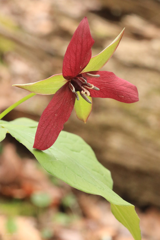
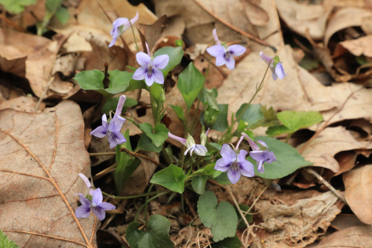


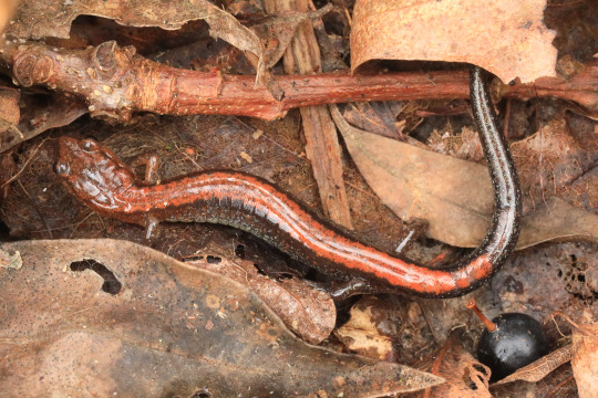
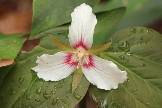
A few mementos from a short hike on the Virgin Hemlock Tail this morning. Cold, damp weather has settled into NC West Virginia, but any rain is welcome following an unusually dry winter and spring (opposite of the West Coast). From top: the ever balletic but stinky red trillium (Trillium erectum); long-spurred violet (Viola rostrata); wood anemone (Anemone quinquefolia), longing for a burst of sun to open its flowers; trailing arbutus (Epigaea repens), a ground-hugging shrub in the heath family; early meadow-rue (Thalictrum dioicum); and an Eastern red-backed salamander (Plethodon cinereus), a terrestrial salamander of rich, damp mountain woods.
#vandalia#west virginia#coopers rock state forest#little laurel run#virgin hemlock trail#spring#april#red trillium#purple trillium#wake robin#stinking benjamin#long-spurred violet#wood anemone#nightcaps#trailing arbutus#early meadow-rue#quicksilver-weed#eastern red-backed salamander#amphibians#appalachia
96 notes
·
View notes
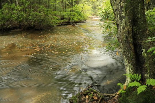
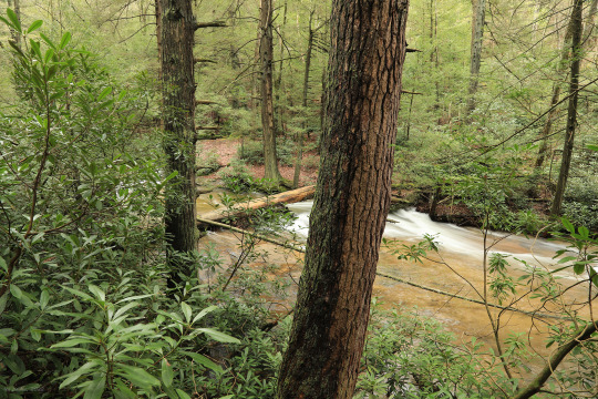
Photo

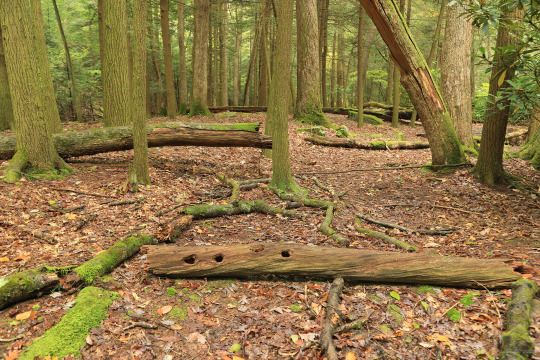
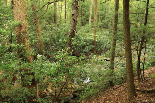
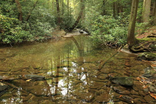

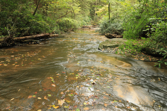
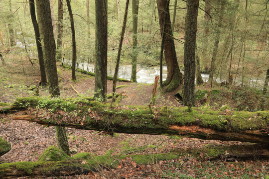
Walk with me: an early October stroll through the virgin hemlock forest along Little Laurel Run in Coopers Rock State Forest. The older I get the more I find myself drawn to animism. It’s so easy to walk in an old forest like this and imagine that everything in it - rocks, trees, moss - has been gifted with a sentient awareness. Not by some hateful, spiteful god, but by the grace of nature in her infinite wisdom.
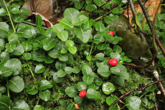
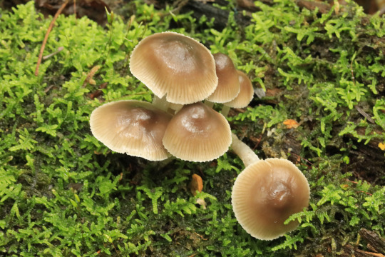
#appalachia#vandalia#west virginia#coopers rock state forest#little laurel run#virgin hemlock trail#virgin hemlock forest#tsuga canadensis#eastern hemlock#canadian hemlock#lophocampa caryae#hickory tussock moth#hickory tiger moth#eurybia macrophylla#big-leaved aster#bigleaf aster#large-leaved aster#mitchella repens#partridgeberry#partridge berry#autumn#fall#wildflowers#flora#berries#fungi
264 notes
·
View notes
Video
Earlier this morning on Little Laurel Run in the virgin hemlock forest (Coopers Rock State Forest).
#appalachia#vandalia#west virginia#little laurel run#virgin hemlock trail#coopers rock state forest#autumn#fall#birdsong#water
116 notes
·
View notes
Photo


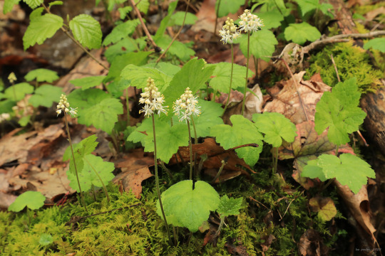

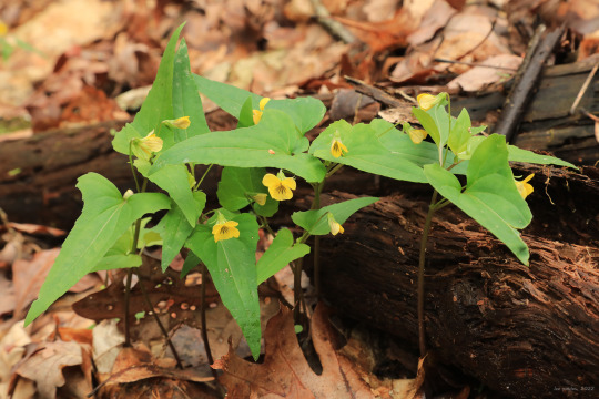


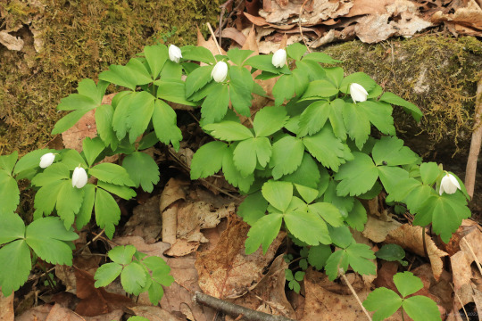
Eastern hemlock (Tsuga Canadensis) is sometimes referred to as the “redwood of the east”, and once-upon-a-time, this was absolutely the case; great expanses of virgin hemlock forest cooled headwater streams and created their own unique ecology. But these old growth forests are largely gone now, with only a few remnant stands scattered along the Appalachian spine. A spring hike through a pristine stand of these gentle giants is an experience to be treasured, providing a rare connection to a primeval world nearly lost to us.
From top: Painted trillium (Trillium undulatum), a lover of old hemlock and spruce forests and the most beautiful and delicate of all the trilliums to bloom in this area; marsh blue violet (Viola cucullata), a moisture-loving violet with club-like hairs at the throat of its flower; heartleaf foamflower (Tiarella cordifolia), which clumps gorgeously at the edges of seeps and brooks; halberd-leaved yellow violet (Viola hastata), an Appalachian endemic with sword-like leaves; and a red eft (Notophthalmus viridescens viridescens) on a perilous journey in search of a pond environment, where it will eventually transform into an adult newt.
#appalachia#vandalia#west virginia#spring#flora#wildflowers#coopers rock state forest#virgin hemlock trail#little laurel run#old growth forest#tsuga canadensis#eastern hemlock#trillium undulatum#painted trillium#painted lady#viola cucullata#marsh blue violet#tiarella cordifolia#heartleaf foamflower#viola hastata#halberd-leaved violet#halberd-leaved yellow violet#notophthalmus viridescens viridescens#eastern newt#red eft
178 notes
·
View notes
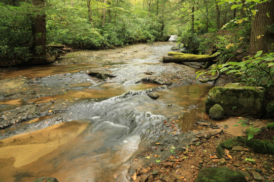
Video
The water was running high this morning on Little Laurel Run after several days of steady rain. This section of the stream runs through the virgin hemlock forest at Coopers Rock State Forest.
#appalachia#vandalia#west virginia#little laurel run#coopers rock state forest#virgin hemlock forest#virgin hemlock trail#spring#rain
66 notes
·
View notes
Last Seen Blogs

elementroar
An Old Geek Soul

rustycowboy
Ezra

devushkadarcy
Darcy From The Moon

ensestanneme
Ensest paylaşım yapıyorum

mayormoon
In a town called Twinmist