#tuscarawas river
Text
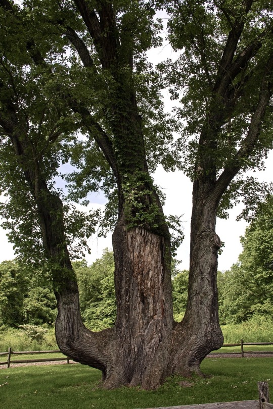
the ‘signal tree,’ a 300-year-old bur oak believed to have been physically altered by native americans to help mark the portage trail between the cuyahoga and tuscarawas rivers
#trees#oak#oak tree#bur oak#great lakes#native american#cuyahoga river#tuscarawas river#akron#ohio#sourced
69 notes
·
View notes
Text
https://www.wlwt.com/article/fishers-colonizing-ohio-after-being-eradicated-from-state/60117483
https://ohiodnr.gov/discover-and-learn/safety-conservation/about-ODNR/news/biologists-find-potential-evidence-of-reproduction-of-fishers-in-ohio#:~:text=A%20fisher%20is%20a%20forest,day%20fisher%20sighting%20was%20confirmed
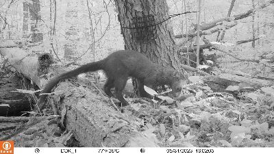
The Ohio Department of Natural Resources (ODNR) Division of Wildlife confirmed that a female fisher, a mammal that was collected as roadkill in Ashtabula County in February 2023, was pregnant. Although that fisher did not successfully give birth, the results are a sign that fishers are returning to Ohio.
A fisher is a forest-dwelling carnivorous mammal in the weasel family. Fishers were extirpated from Ohio in the mid-1800s. In 2013, Ohio’s first modern-day fisher sighting was confirmed. Since then, there have been 40 confirmed fisher observations across nine northeast Ohio counties (Ashtabula, Columbiana, Geauga, Trumbull, Mahoning, Lake, Jefferson, Harrison, and Tuscarawas). Two-thirds of those sightings occurred in the last three years. Fishers are moving westward from established populations in Pennsylvania and naturally coming back to Ohio.
Fishers, such as the one here on a trail camera, have been confirmed in nine northeast Ohio counties through verified sightings. The fisher is a medium-sized mammal related to river otters and weasels.
#good news#environmentalism#science#environment#nature#animals#fishers#ohio#usa#conservation#endangered species
128 notes
·
View notes
Video

flickr
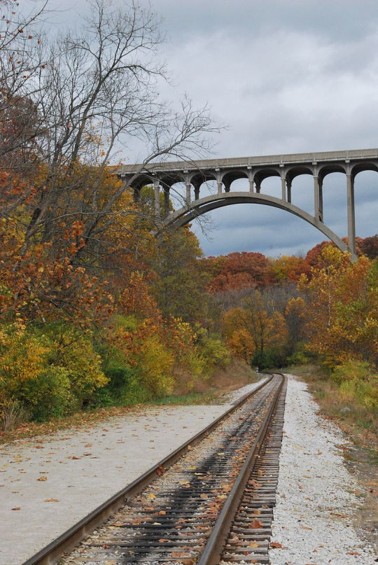
Brandon Townley por Center for Railroad Photography & Art
Por Flickr:
Gorgeous side lighting on the NS office car special on the unusual curved truss bridge crossing the Tuscarawas River in Massillon, OH. Vertical lines, curved track and classic EMD cab unit make this picture pop.
6 notes
·
View notes
Text
Last week there was a fucking oil spill in the Tuscarawas river in barberton, Ohio and I can not believe there has been ANOTHER ecological issue in this area, this is such a fucking nightmare year for Ohios natural resources RIP
#(this one is much much closer to where i live than east Palestine btw)#what the fuck is happening???
3 notes
·
View notes
Text

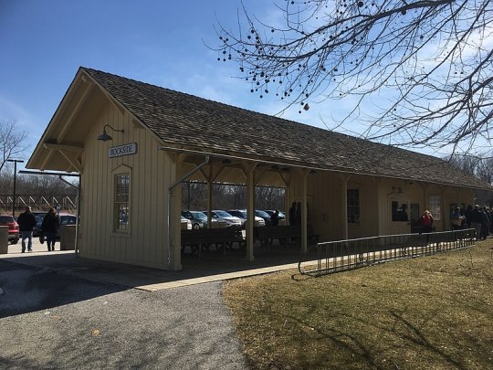

Valley Railway Historic District
7900 Old Rockside Rd.
Independence, OH 44131
The Valley Railway Historic District is a historic district partially located in the Cuyahoga Valley National Park, extending from Rockside Rd. in Independence, Ohio, to Howard St. in Akron, Ohio. The Valley Railway was constructed in 1880 to link Cleveland's growing steel industry and the rich coal fields of the Tuscarawas River Valley, extending south to Zoarville. Although the first railroad came to Cleveland in 1854, the majority of the rail lines ran east–west and did not connect the metropolitan and industrial centers of Cleveland, Akron and Canton. The Valley Railway was built next to, and sometimes on top of, the Ohio and Erie Canal. The Railway provided a faster transport for the coal needed to fuel the new industrial economy.
Although the railway primarily functioned as an industrial and freight carrier, the railway published "The Travelers and Tourists Guide to the Valley Railway!" to promote its passenger service. This guidebook describes the origins and character of many towns and notable natural features along the route. The Valley Railway brought an increase in noise and pollution to the quiet rural valley. The guidebook was a common promotional piece used to make the railway seem more recreational than industrial. Many believed that the presence of the railroad in pastoral landscapes all around the country, referred to as the "machine in the garden," represented a significant shift away from an agrarian society towards an industrial one.
In 1895 the Valley Railway became the Cleveland, Terminal and Valley Railway. In 1915 the line was absorbed into the Baltimore and Ohio system. Although many small independent lines from this era were absorbed into larger lines and acquired parallel tracks, the Valley Railway retains single track alignment and has been well preserved. A great deal of the track runs through the Cuyahoga Valley National Park, which has preserved the cultural landscape of the valley and prevented modern intrusions into it. Today the Cuyahoga Valley Scenic Railroad runs excursion service extending from Cuyahoga County to Canton. It was added to the National Register of Historic Places on May 17, 1985.
1 note
·
View note
Text

2023-04-27 Heron in flight, Tuscarawas River, Massillon OH
0 notes
Link
Four teenagers from Ohio were rescued after becoming stranded on a remote area of the Tuscarawas River on Memorial Day, authorities said.
0 notes
Text
All Done Painting & Power Washing in Massillon, OH
All Done Painting & Power Washing is one of the most famous painting and power washing companies in Massillon, OH. They offer exceptional home repair service these days. The company has provided excellent services to the people in the area for so long. No wonder many individuals trust their services. Besides, it is interesting to note that they promise to stand behind their work. Since their customer service is responsive and prompt, there is nothing to worry. In addition, they are dedicated to the satisfaction of every customer. Isn’t that the primary thing we need at present? That is really amazing.
All Done Painting & Power Washing
We know that All Done Painting & Power Washing provides excellent painting restoration services these days. In Massillon, OH, you can count on the said realty to help you change your environment these days that provides inspiration and motivation. Specifically, they offer roof cleaning. When cleaning roofs they only use a softwash method. The said technique ensures there is no shingle damage and that we kill all lichen, algae, and mold that has attached to your roof. Aside from that, they promise to communicate with the customer after every job. They will also utilize every means available to safely remove marks on your surfaces.

Massillon, OH
Many people want to know the interesting historical details of the Massillon, OH location. It is also interesting to study its early settlers. The original settlement of Kendal was founded in 1812 by Thomas Rotch, a Quaker originally of New Bedford, Massachusetts, and Hartford, Connecticut. Additionally, James Duncan of New Hampshire first settled in Kendal before recording the plot for Massillon on December 6, 1826.Duncan, known as the city's founder, named the town after Jean Baptiste Massillon, a French Catholic bishop, at the request of his wife. Lastly, the town plat was established along the east bank of the Tuscarawas River.
Sippo Lake Park
We know that Sippo Lake Park is a famous landmark in the Massillon, OH area at present. Many people go there to unwind and spend time with family members. In the said place, you can hike, bike, fish, and paddle for fun. The trails line the shoreline, loop through the wetlands and forests, and connect the three different park entrances. With 300 acres to explore, plenty of options for self-guided activities, plus scheduled programs, Sippo Lake Park is an exciting destination for a full day of fun. This great escape is located right between Canton and Massillon. It’s truly a perfect place to visit these days.
Portion of Lincoln Way in downtown Massillon closed after partial collapse of 2 buildings
There are many shocking news reports in the Massillon, OH area. One of the popular reports is about the partial collapse of two buildings in the city. Reportedly, a portion of Lincoln Way (State Route 172) is closed in downtown Massillon due to a partial collapse of two buildings. In an email to 3News, Massillon Safety Service Director Barb Sylvester explained that the back wall of the buildings at 14 and 20 Lincoln Way East broke down last Friday. Aside from that, Sylvester says the city's aim is to get the two buildings safely to the ground as soon as possible.
Link to maps
Sippo Lake Trail
Perry Township, OH 44708, USA
Continue to 12th St NW
2 min (0.4 mi)
Continue on 12th St NW. Take Jackson Ave NW and Stuhldreher St NW to Candleberry St NW in Jackson Township
10 min (4.9 mi)
Follow Candleberry St NW to Timberidge Ave NW
2 min (0.4 mi)
All Done Painting & Power Washing
4307 Timberidge Ave NW, Massillon, OH 44646, United States
0 notes
Text


Carol Schell Letosky
Since everyone loved the deer photo I thought I’d share the rest I took these this morning! Playing in the Tuscarawas river!
13K notes
·
View notes
Text

On a cool and sunny June day, I am paddling peacefully through miles of deciduous hardwood forest, contemplating the scenery and natural beauty surrounding me. I see great blue herons wading in the swift moving water searching for lunch and hear the rattle of a belted king fisher before he makes his killer descent into the crystalline waters below. I catch a glimpse of an osprey, its white underbelly circling ominously over head. Canada geese and mallards cruise lazily along side me. No, I’m not traversing through the Adirondacks or Acadia, I’m a few miles north of Akron on the Cuyahoga River in beautiful Northeast Ohio!
Last month, I felt the urge to more intimately connect with the Cuyahoga, the aquatic spirit-godmother of Northeast Ohio. For years I’ve hiked, run, and biked through its namesake valley and along its various tributaries, I’ve marveled at the stone structures it helped to create, and the cultural metropolises it helped to build. I absolutely love this river, which I consider to be an omnipresent maternal entity helping to guide us to a better future. When the river is healthy, we are too.
I’ve seen the Cuyahoga so many times at so many different locations, but kayaking upon it offered me a new perspective. The river takes you where it goes with utter disregard for your comfort or predetermined destination. I put-in in the Merriman Valley directly north of Akron’s Cascade Valley MetroPark and paddled eight miles north to the river access point under the Bolanz Road bridge in the Cuyahoga Valley National Park. During my trip, I saw a variety of wildlife and paddled easily through various class-one rapids. I had to dodge fallen trees (a particular sycamore north of the Ira Road bridge was somewhat challenging) and maneuver through the various twists and turns of the lower Cuyahoga river. The route took me near the Akron water treatment plant which has undergone extensive updates and expansions throughout the last few years (possible future post), at the behest of both state and federal governments. Despite my proximity, I did not detect any putrid smells from the plant. I barely knew it was even there.
Paddling your local river, whether it be the Cuyahoga, Chagrin, Grand, Black, Vermilion, Ashtabula, or Tuscarawas, fosters a greater connection between you, the resident, and the river with which you have a much deeper connection than you may initially assume. Your tap water likely comes from here and your waste water, upon treatment, likely returns here. The birds at your feeders may also spend time here. Other animals you may see in your yard might drink from the river’s banks or live in a habitat it provides. It is extremely important that we protect our rivers and the ecosystems along their banks. There’s currently a political movement of concerned citizens in Akron and Cuyahoga Falls working with their respective cities’ governments to develop a plan to preserve green space around the lower Cuyahoga and the Merriman Valley. Their arguments range from climate related ones, to infrastructure, tax, and health concerns. For more information, please visit preservethevalley.com.
Kayaking the Cuyahoga was a fabulous way to spend a random Friday afternoon in June. The river is a state designated water trail, meaning that all of its nearly 100 miles are recognized by Ohio as an important recreational area. Additional put-ins and take-outs are being constructed by the Cuyahoga Valley National Park and other local park systems to provide greater ease of access for kayakers. The Cuyahoga Valley Scenic Railway will even transport your boat for you. The river is clean and represents much of our region’s history. Additionally, it is a perfect stage to intimately view the area’s diverse flora and fauna. Get out on to the Cuyahoga river and start paddling. I promise you won’t regret it.
#cuyahoga river#cuyahoga#cuyahoga falls#akron#exploreneoh#ohio#kayak#kayakers#river#northeast ohio#lake erie#cuyahoga valley national park#national park#wilderness#united states#water
2 notes
·
View notes
Text
Hometown Haunts and Legends
There are some very interesting yet not-widely-known haunts, legends, and creepy oddities here in my small Ohio town and several nearby towns and locations (most within a 20-minute drive), so I thought I would share them with you over the coming weeks.
From USA Today: "Incorporated in 1808, New Philadelphia, Ohio, is a small town [current estimated population 17,417] located about 70 miles south of Cleveland along the Tuscarawas River. It was fashioned after Philadelphia, Pennsylvania, and is the first European settlement in the State of Ohio. In addition to its historical significance, the town allegedly has a wealth of paranormal activity. When visiting the area, take a tour of its strange and mysterious haunted locations."
The above article mentioned two or three locations, with little info if any. I'm here to give you the scoop on ALL of our spooky locales!
Hauntings & legends:
Stone Quarry Hill • Warlock's Grave, Ridge Road Cemetery • Schoenbrunn Village • Post Boy Road & Post Boy Tunnel • Zoar Hotel • Inn on the River • Fort Laurens • Gnadenhutten Moravian mission & G'hutten Massacre burial mound • Lock 17 • Ghosts of Roscoe Village
Fascinating oddities:
The wax head of William Quantrill • One of Quantrill's THREE grave sites, at Fourth Street Cemetery in Dover (he's been divided up and scattered around, not just moved!)
Bonus:
A bit farther away (but still under an hour) and virtually unheard of even locally, are three sites in one small, very remote area: The ghost town of Egypt, Ohio • Louisa Fox murder site & nearby grave at Salem Cemetery • The Ghost of Butter Milk Road
I've done countless hours of research, and I'll be including write-ups I've found online as well as additional info I've dug up myself while trying fill in some blanks. As I post each story I'll also link above to that individual post, making this one a master list of story links.
A few of these are real doozies, so strap in for some seriously wild tales!
45 notes
·
View notes
Photo

Seven Ranges Terminus
Farber St SE
Magnolia OH 44643
Seven Ranges Terminus is a stone surveying marker in Rose Township near Magnolia, Ohio, that marks the completion of the first step in opening the lands northwest of the Ohio River to sale and settlement by Americans. West of Magnolia at the junction of Stark, Tuscarawas, and Carroll counties, it extends into Stark and Tuscarawas counties. This survey marked the first application of the rectangular plan for subdividing land.
With victory in the Revolutionary War, the Treaty of Paris granted the United States lands north of the Ohio River, south of the Great Lakes, and east of the Mississippi River, called the Northwest Territory. The US Congress adopted the Land Ordinance of 1785 as a method for surveying, selling and settling these lands. This ordinance established a method for surveying the land into a grid of six mile square survey townships. These townships were to be arranged into vertical rows called “Ranges.” The first ranges were to be measured from a meridian along the western boundary of Pennsylvania. The townships in each range were measured from an east-west line called a baseline. This became the genesis of the techniques used in the Public Land Survey System.
The 1785 ordinance called for the Geographer of the United States, Thomas Hutchins, to personally supervise the first survey. It called for Hutchins to establish a Point of Beginning on the north bank of the Ohio River where it leaves Pennsylvania. From there he was to establish a baseline seven ranges wide, (42 miles), called the “Geographer’s Line,” and then survey north-south lines each six miles to mark the edges of the ranges, and then establish the south boundary of each township. After each seven ranges had been completed, the Geographer was to return plats to the federal government for marketing and sale.
Hutchins, along with prominent surveyors from ten states appointed by Congress, began surveying the Geographer's Line in 1785, but stopped after only a few miles because of troubles with Indians. In 1786, with protection of troops from Fort Steuben, Hutchins resumed the survey. In September 1786, Hutchins placed a stone cadastral survey marker at the west edge of the seventh range on the Geographer's Line, a spot later to be known as the Seven Ranges Terminus. After the first surveyed seven ranges had been completed some years later, the survey tract was known as the Seven Ranges, or Old Seven Ranges.
The survey marker lies at the corner of four townships, three counties, and three survey tracts. The marker is property of the federal government, but surrounded by private property. It sits about 288 feet to the west of a public road. The granite cadastral survey marker is six inches square in cross section with an inscribed X on top, and about a foot protrudes from the ground. Much more is buried. The Canton Repository said on August 7, 2003, that the stone leans somewhat because someone tried to dig it up some years ago, before realizing how deep it is buried. Another plausible reason for lean would be two centuries of frost heave. The Seven Ranges Terminus was listed with the National Register of Historic Places on December 12, 1976 for its association with the historic significance of Thomas Hutchins.
1 note
·
View note
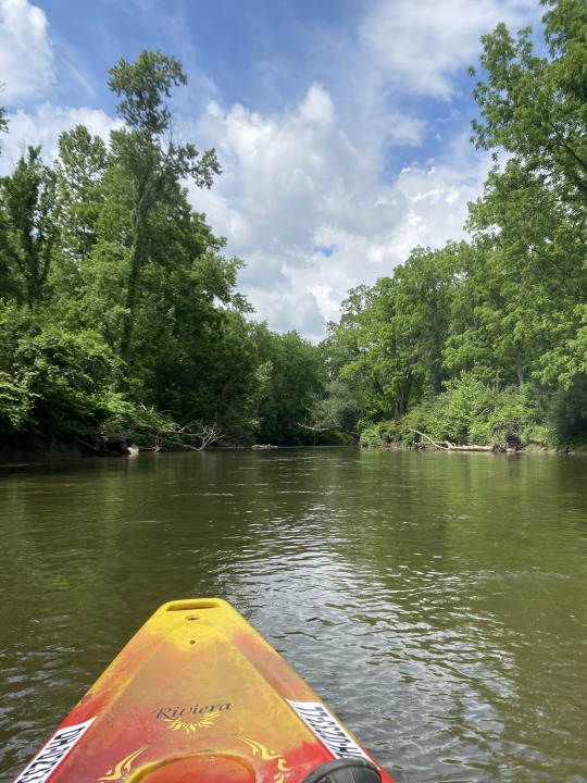
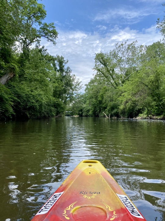
Photo
Took the kiddos kayaking 🚣♀️💕 (at Tuscarawas River) https://www.instagram.com/p/B1omTpynox_/?igshid=1fb8qnylo7yj
1 note
·
View note
Text
[Video] Life Beyond Addiction – Traci Buzzeo
Traci is the mother of five wonderful kids. She is a board member for Beneath the Shade Women’s Transitional Living House. Her father struggled with alcohol and drugs. She volunteers at River Haven Women’s Residential Treatment Center and the Tuscarawas County Jail. She leads three SMART Recovery meetings including a women’s only meeting for Beneath […]
from RSSMix.com Mix ID 8241842 https://ift.tt/3pg1olw
0 notes
Text

2023-04-27 Goose with goslings, Tuscarawas River, Massillon OH
0 notes
Last Seen Blogs

nknora
souco

waleeddora
Waleed Dora

janekuzmiart
• • J A N E K U Z M I • •

notisyourlife
HAINE

yokaiwatchconfessions
Yokai-Watch Confessions