#imaginary maps
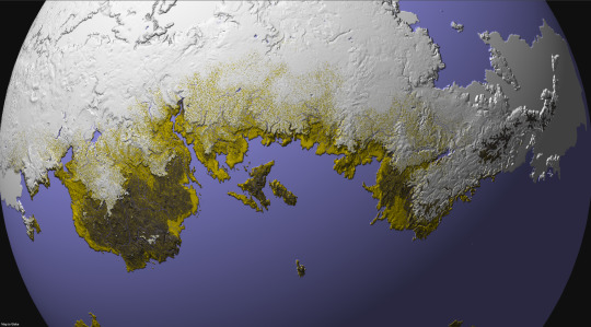
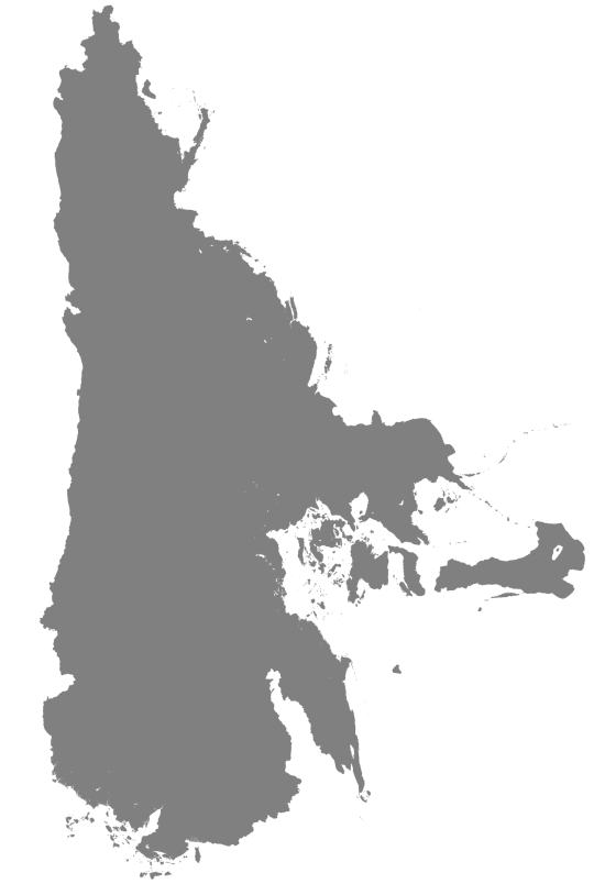
Photo

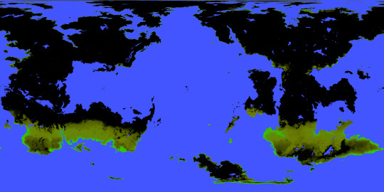
The Hoenn Region as depicted in Pokemon Emerald
1K notes
·
View notes
Photo
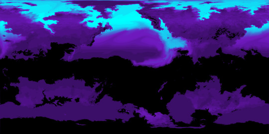
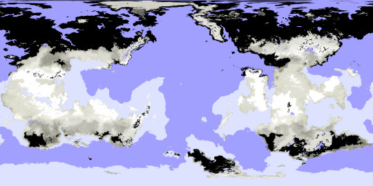
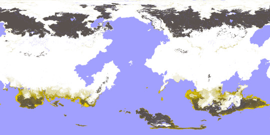
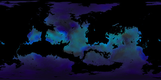
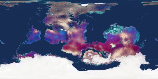
Some months ago, I created a series of maps and diagrams for @iguanodont‘s Birdbug worldbuilding project, representing the planet inhabited by their original species and its planetological data. This isn’t the first time I mapped out this planet, as I was also commissioned by Ripley back in 2020 back when I didn’t have nearly as much experience and knowledge as I do now. Two years later, I’ve been commissioned once again to revisit this world and its peculiarities.
This first map (in Equirectangular projection and poles-centered perspective) depicts the elevation for this planet, with a color gradient applied to the data.
Here is the same elevation data, presented without the color gradient.
This time, the elevation is presented with bodies of liquid water included, such as rivers, oceans, and lakes.
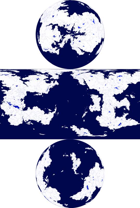
and in this one, the water is isolated from the other data, against a white background
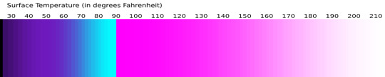
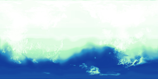
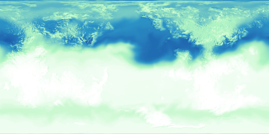
Next, there are the surface temperatures that occur on this planet, the key to which is shown above. The four maps below show the seasonal temperatures for land and sea, in order of Northern Spring Equinox, Northern Summer Solstice, Northern Autumn Equinox, and Northern Winter Solstice.
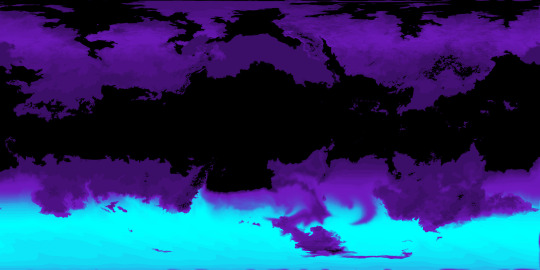
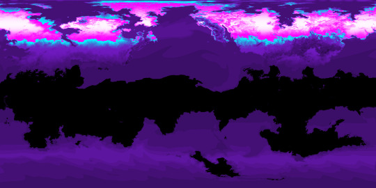
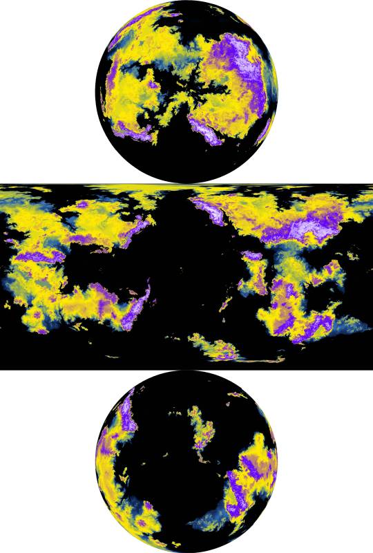
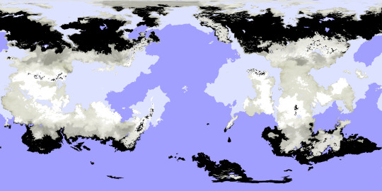
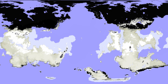
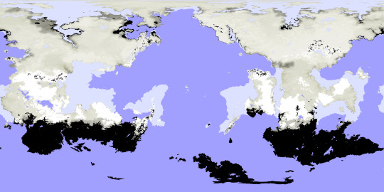
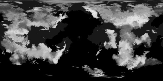
Correlating closely to the above data is the snow and ice cover, which is fairly extensive on this planet owing to its high obliquity and distance from its star. Land ice only occurs where the snow falls and is compacted year-round, but snow and sea ice can be much more seasonal.
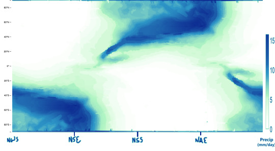
Seasonal precipitation levels were another important phase of this project, and the below diagram shows those levels for a given latitude (y-axis) on a given date (x-axis), with a key attached.
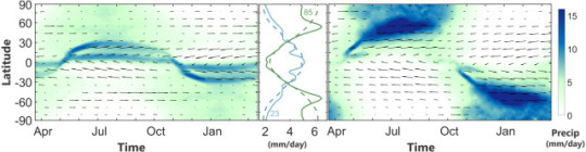
My reference for creating the above graphic is the figure below, which comes from a 2019 paper by A.H. Lobo and S. Bordoni titled “Atmospheric Dynamics of High Obliquity Planets”, and shows Earth’s precipitation levels compared to those of a planet with an 85° obliquity.
The following maps can now be better understood in light of these diagrams and keys.
-Northern Spring Equinox
-Northern Summer Solstice

-Northern Autumn Equinox

-Northern Winter Solstice
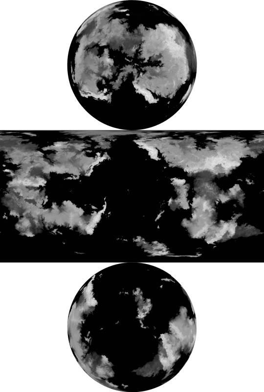
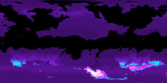
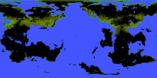
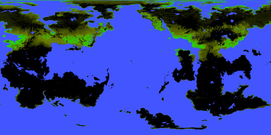
I was also tasked with mapping out the extent and density of this planet’s vegetation (or at least its alien equivalent), and from this you can see how wildly it varies by season, with very few year-round holdings. Precipitation is a major factor in where it is possible for plants to flourish, but snow cover and the extreme temperature swings limit it too. Near either pole, for example, within the space of a year temperatures soar far above Earth’s upper limits and also plummet below freezing; if either extreme were to be the annual norm for a region, some plants might adapt to those conditions, but because of the wild fluctuation any adaptations to one extreme would leave plants especially vulnerable to the other. These regions, then, remain barren regardless of rainfall or brief windows of mild temperatures, while areas with less wide temperature ranges allow for at least brief periods of flourishing.

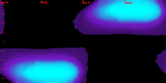
Determining the surface temperatures for this planet required a lot of background work. The first piece of the puzzle for this was knowing the number of daily hours of sunlight for a given latitude and date, which is exemplified first in this diagram for Earth:
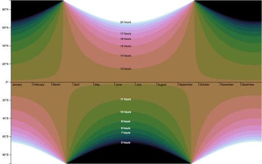
and then for the Birdbug planet, below. Since this planet rotates on an axis of 60 degrees, there are many more latitudes within range of either pole that experience periods of sunlight and darkness lasting longer than a day. The higher the latitude, the longer this period lasts, with the poles themselves experiencing either condition for half a year at a time.
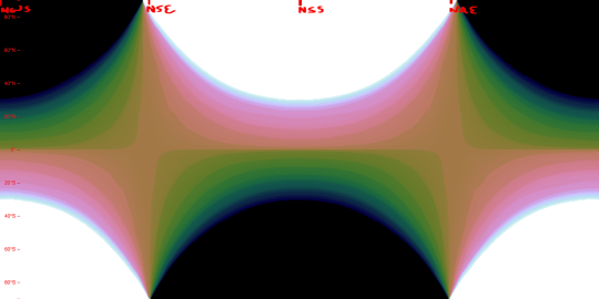
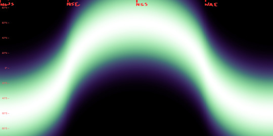
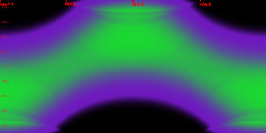
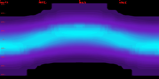
Another important factor is the height to which the sun is seen to rise (more scientifically, the angle at which the sun’s light hits parts of the planet’s surface), seen here first for Earth and then for the Birdbug planet. In these diagrams, white represents the sun reaching the zenith of the sky (meeting the surface at a 90° angle), and black represents the sun failing to appear above the horizon (meeting at an angle of 0° or below), while shades of green and purple stand in for angles between those extremes. For Earth and the Birdbug planet alike, the sun reaches the zenith within the bounds of either planet’s Tropic circles of latitude, and fails to rise at all only within the Polar circles of latitude; the difference in obliquity means that the Birdbug planet’s key circles of latitude are flipped compared to Earth’s.
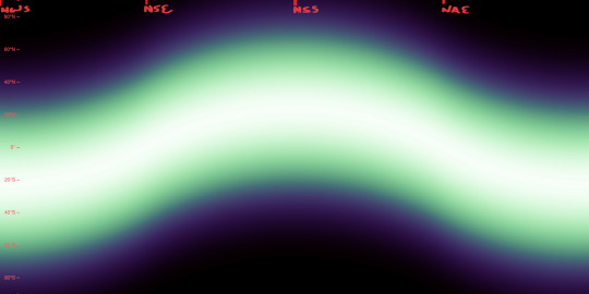
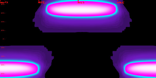
The duration of sunlight and the angle at which that sunlight is reaches the planet’s surface determine a planet’s Insolation, that is, the amount of solar energy it receives. The first image below is a preexisting diagram of Earth’s Insolation, where it is measured in watts per square meter. The next two images are my own attempts at replicating this data for Earth, and then for the Birdbug planet.
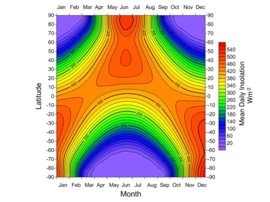
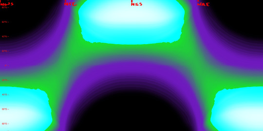
As seen in the diagrams above, Insolation on the Birdbug planet differs from Earth not only in its latitudinal distribution, but also in its sheer intensity at the higher latitudes. Compared to Earth there are twice as many latitudes for which the sun is shining longer than one rotational period, and many of those latitudes see the sun shine at a direct or nearly direct angle, whereas the Polar circles of latitude on Earth see the sun shine much more obliquely.
Below, we can see the data that all the above figures were instrumental in finding: that is, surface temperatures. The first image is a preexisting figure that measures Earth’s mean surface temperatures by date and latitude, and below that is my attempt at replicating the data by my own process.
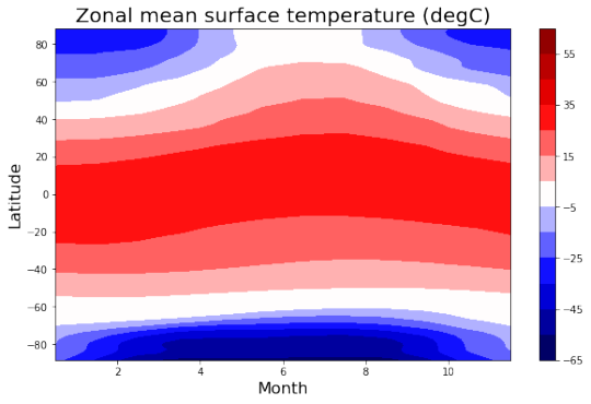
This is done not by just copying the seasonal Insolation data, but by also factoring in the yearly average for each latitude.
Above, we see the temperatures of the land by date and latitude, and below, we see the temperatures at the surface of the sea, which lag behind the land temperatures and remain comparatively mild.
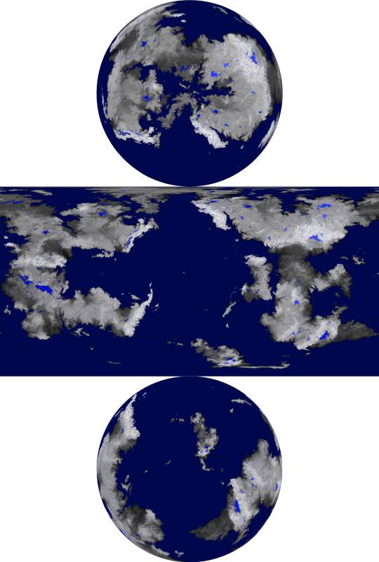
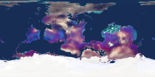
Lastly, here’s an image I created to combine the snow and ice cover as well as the vegetation extent and density, as of the Northern Spring Equinox. This, along with the elevation map also seen here, is what I uploaded to maptoglobe.com in order to produce the screenshot at the top of this post.
These maps and figures (except for the preexisting ones) were all created in Photopea. Higher resolution versions of many of these images can be seen in my dedicated Reddit posts, linked below:
reddit post one, reddit post two
2022
#mapmaking#imaginary maps#worldbuilding#major project#imaginary planetology#elevation#waterways#river systems#surface temperatures#ice and snow cover#sea ice#precipitation#vegetation#Insolation#high obliquity planets#explanatory diagrams#digital rendering#Photopea#Birdbug worldbuilding project#Birgs#Birgworld#2022#digital painting#extremely long post#Christopher Maida Artwork
616 notes
·
View notes
Text
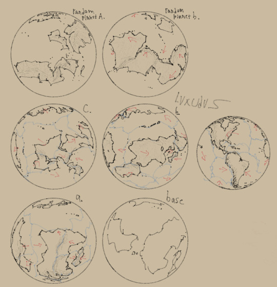
Ey dont worry everyone the Neo-Anthropocene isn't dead (yet) I still have plenty of ideas on where to take this project. For awhile now i've been feeling like the og map of Irou, the homeplanet of my main species atm: the Ikleud. No longer feels that natural or detailed.
Above are mostly concepts of an Irou with more realistic looking coastlines and more interesting continent shapes. The main ideas I've had for a long while is that all the landmasses were conjoined into a single northern super continent that broke up around either 150-100 mya or 300-250 mya. And that most of Irou's continents are arranged horizontally instead of vertically to differentiate it more from earth.
The top two planets however don't have anything to do with Irou and were just coastline warmups. Though random planet A. could look good for those neurodivergent posthumans, the Savunato. who's actual lore dump is still in the works.
Also i used this guide to make these coastlines and is the main reason i wanna get back into remaking Irou. :)
#my art#art#artist on tumblr#worldbuilding#alien planets#planet#fictional map#imaginary maps#neo-anthropocene
11 notes
·
View notes
Text
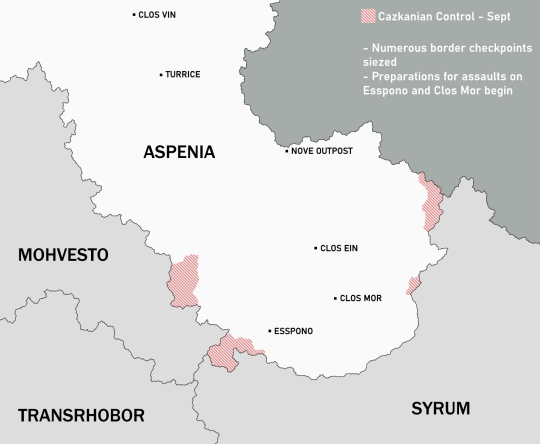
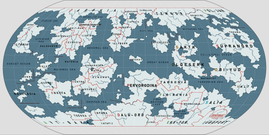
The Aspenian War, Aug 3, 160 - Mar 18, 161
This will be a big post with lots of images, but I'm excited to talk about this!
Though it only lasted for half a year, the Aspenia War as it came to be known had far-reaching and long-lasting consequences. These impacts would linger for years, even decades after the war concluded, and would add fuel to the growing flames of the political climate of 173 and the three-sided cold war Hessdalen found itself in.

This was southern Aspenia before the war began. Tensions had been growing with the Cazkanians for several years. Though they did not directly border each other, Cazkania controlled Mohvesto, Syrum, and Transrhobor as its satellites. From here it had been massing troops and equipment along the Aspenian border. Never believing they would actually attack, the Aspenians ignored this. Leaving them vulnerable.
The Cazkanians attacked in early August, storming border crossings and securing defensive positions in small towns and the few natural barriers the desert had to offer. The Aspenians went into full defensive mode until the country could properly mobilize, a task that would take precious time.
Also, until this point the TCA and Cazkanians had a shaky, but functional, relationship. In fact on August 3rd a joint scientific conference was underway in north-west Cazknaia with some of the alliance's best scientists and engineers in attendance. When news broke of an attack though, the TCA cut all talks with Cazkania and urged all of its citizens to return home. The conference ended abruptly and messily as all TCA nationals fled the country.
However, there were some who did not escape. These individuals, among them some children of the visiting scientists, were never heard from again. The Cazkanian government ignored all requests from the TCA for these people to be located, greatly contributing to the decline in relations.

By October the Cazkanians had made further gains, but by the end of Septemer the Aspenians had managed to ready themselves. They took a firm stand in Esspono as the city came under siege, and managed to push back the invaders in some locations. But unfortunately, for every step they took forward in one place, they took two more back in another.
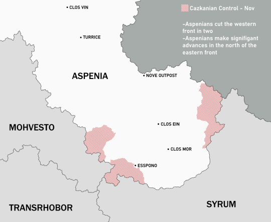
October turned out to be a relatively successful month for the Aspenians. They continued to hold out in Esspono, and by November they had cut the western front in two and made significant gains in the northeast.
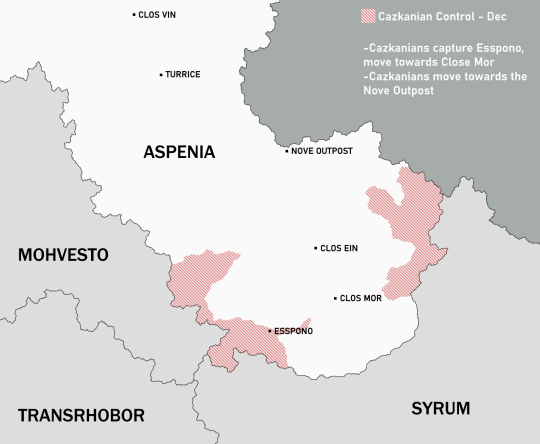
Unfortunately, time was weighing on the Aspenians by December. Esspono had fallen, and the Cazkanians were making a two sided charge for Clos Mor and the Nove Outpost. If Nove was captured, the key supply route from the core Aspenian territory to their forces on the front would be cut off.

The Cazkanians enacted a new goal that had formerly been considered too difficult: Taking Turrice. If they could capture the only crossing point of the Pelgriece canyon, the war in the south would be finished. So their forces move in from Mohvesto along the canyon.
Seeing the Cazkanian plan clearly, the Aspenians began to panic. Though they had been successful in defeating the first attack on Clos Mor, they knew if they lost Turrice that all would be lost. So they diverted more men to the new front.
The Aspenian army had a growing problem: morale. Their army was full of forced recruits, poor men from the lowest tiers of the caste system that were losing the small bit of connection they had to the country that ruled them as the war dragged on. The Cazkanians picked up on this and exploited it. Though their country was authoritarian and with few liberties, it was an improvement to the slavery of the Aspenian caste system.
The Aspenian soldiers began questioning their purpose, and if their enemy was really invaders... or liberators.
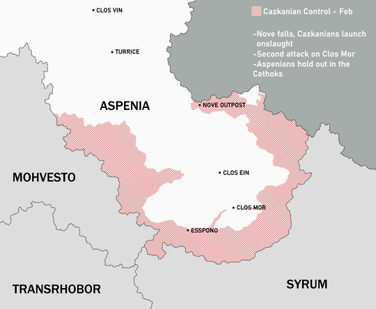
The Cazkanians captured Nove Outpost. And with it they cut off the easiest supply route for the Aspenians. With that, they began an onslaught that overwhelmed the Aspenians.
Desertion became rampant on the Aspenian lines, with many joining the Cazkanians after being subjected to their propaganda.
A group of Cethok fighters who knew the mountains well held out despite being cut off and even made some gains, but this was the only good news for Aspenia.
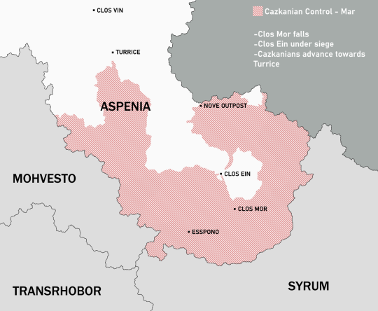
Despite being fought for every inch, the Cazkanians crawl towards Clos Ein and Turrice.

On March 18th, 161, Clos Ein fell to the Cazkanians. With this the Aspenians agreed to negotiate a peace, and were forced to give up every bit of their territory south of the Pelgriece canyon. This region became a Cazkanian puppet state that adopted Oretekism and completely abolished the caste system. And while the regime was oppressive, it was an improvement for the poor classes who came to see themselves as liberated. And so South Aspenia was born.
Aftermath
The Aspenian War had major consequences. It got exactly what Cazkania wanted, that being the final piece of their natural border wall. But this act of aggression on a peaceful nation, even though it was not a member state, led to the collapse of relations with the TCA, bringing the three-sided cold war into a new stage.
Most members of the highest Aspenian classes left the south before the Cazkanian forces could reach them, either moving to the north or abroad. Some landed in Rovaya, becoming important figures in that country's notorious shady side. Of those who did not leave, their property and wealth were stripped away, and they were integrated with those they used to subjugate.
Aspenia isolated itself from the world in humiliation, partly at least. The government was also afraid that the rest of their country would be exposed to the lure of "liberation" and demand they be freed of their caste as well. So the oligarchs made the desition to isolate from the world to protect their ancient system from a revolution.
The TCA was very vocal about the missing persons, with families wanting to find their loved ones again. But the Cazkanians would not grant a single response on the matter, and sadly as the years went by it became outshone by other matters in the TCA governments. Most families had given up hope by 173.
The historic trade corridor that was the Arch of Turrice was shut down to all traffic. At one time the land bridge over the canyon saw a constant flow of wealth cross it each day. But after the war it became desolate, and a point of interest in global geo-politics.
A Cazkanian Chief General was appointed to be the head of state of South Aspenia and direct the occupation. It was not difficult to integrate the majority into the Cazkanian sphere as they were given a better life under this new rule.
Today Aspenia remains divided, and unification is an idea far out of reach.
#worldbuilding#fantasy world#fictional world#writeblr#fictional history#writing#fantasy maps#imaginary maps#fantasy war#fantasy politics#cozar#oc lore
8 notes
·
View notes
Text
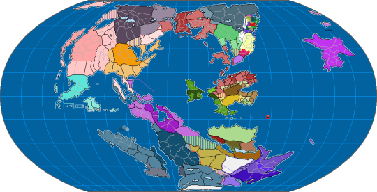
An Overview of the Map of Tarun
Map of Tarun, as it is traditionally depicted with East at the top. Popularized by Later Pashtoi explorers, the east-up orientation of Tarunese cartography follows the flow of the great Tarun River, the namesake of the continent (literally called "The Lands of the Tarun"). The river, a centrifuge for the development of civilization, trade, and a strategic chokepoint linking the North and South while bypassing the perilous central mountains, it's no wonder that the Pashtoi Confederation, one of Tarun's most influential nations, formed in the fertile Imu Basin in 698 Pestaran.
Tarunologists also speculate the source of the east-up orientation could also be a product of Jammuphobia. Another influential civilization formed at the mouth of the Tarun, which empties into the Jammub Water, the Jammubs were historically generally regarded as warlike barbarians. Thus, with the east on top, Jammub civilization, as well as the equally scorned peoples of the western rainforests, are depicted at the bottom of the world.
#worldbuilding#geography#cartography#maps#imaginary maps#imaginaryworlds#tarun#pashtoi#jammub#history
14 notes
·
View notes
Text
Map of my current fantasy world, Theia. The one on the top is an updated version of the map with some improved borders, bottom is a more outdated version of the map, but with accompanying lore, though I'll fully update everything in the future.
Main premise is that the world is undergoing a cold war between major mago-industrial powers with one story I'm working on taking place within the Io Consortium, which is an unstable megacorporate state being fought over by the Demonic Confederacy and the Avalonian Empire.
10 notes
·
View notes
Text

#brotherhood of steel#fallout 4#imaginary maps#ss2#sims settlements 2#map#battlemap#logistics#fo4#minutemen#railroad#spoilers#modded#fanfiction#sole survivor#jake evans
5 notes
·
View notes
Text
I also have this map, set in a different universe of my own creation. I like to make maps. maps are fun.
5 notes
·
View notes
Text
Been working on a little something:

9 notes
·
View notes
Text
So, I've not really used tumblr much before. Absolutely no judgement on the site, but I'm terrible at managing my attention between different places. If I start using one place I *will* forget another, it's like I have limited slots. However, for Reasons that are probably fairly obvious, it suddenly feels sensible to try to explore alternative avenues for social media, and honestly I could do with less algorithmic feeds in my life.
So, I'm going to start sharing the backlog of stuff I've made on here. Most of it is either maps or other digital graphic pieces I've made, or otherwise relates to worldbuilding of some sort. Much of it is alternate history but by no means all of it, I tend to like exploring different genres and styles, particular as I've been making maps digitally for over a decade now.
This map belongs to a specific alternate history I've been working on called They Come In All Colours, which began as a one-off scenario that grabbed me too strongly, and so I got pulled into the details. TCIAC isn't focused on the British Isles, but I am from there, so it felt kind of necessary and interesting to actually make a map like this. For context, the alternate history is one that involves the Habsburgs never becoming more than the lords of the titular castle. The current date is around 1865. England, in this timeline, along with Wales, constitutes part of a republican United Commonwealth/s in combination with large parts of what we'd call the Netherlands, with a titular head of state called a Steadholder in English (and a Stadtholder in Dutch), but in reality ruled primarily by the Parliaments General. Rochester (by this time the greater Rochester+Chatham area) serves as the U.C's official political capital, and is deliberately not coincidental with any of the major commercial centres in any of the Commonwealth's constituent parts. So London and Antwerp for example are actually larger cities than Rochester, though the former is smaller than the actual London would have been by this date in real history.
Scotland and Ireland are currently separate Kingdoms, but historically there was a personal union (in other words, different nominal countries, same sovereign king) between Scotland and Ireland in this timeline that lasted until the early 18th century. Scotland has a somewhat different border with England than in our own timeline, and remains Catholic majority (as opposed to being either 'Lollard', i.e Wycliffite, which the U.C is, or Hussite, which significant chunks of mainland Europe are). Ireland also remains Catholic, and is fairly active in its mercantile relationships with the rest of the world.
The map itself was primarily made in vector using Inkscape. However, significant additional work was done in Photoshop, both for texturing/weathering of the page and the text but also to add the elements that make it look like it's from a book with tabbed pages.
And with that wall of text, here we are.
23 notes
·
View notes
Photo

Map of the Independent Republic of California
by u/Ben1152000
174 notes
·
View notes
Text


Once I had enough high-resolution climate data to work with, the final part of the Climate phase was the creation of maps with discrete climate zones, which I produced in both the Trewartha classification scheme, left, and the Köppen classification scheme, right.


The final phase of the Ayrum mapmaking project was to create realistic satellite style maps, which began with mapping out soil colors and the ground cover of vegetation generally and tree-analogues specifically.
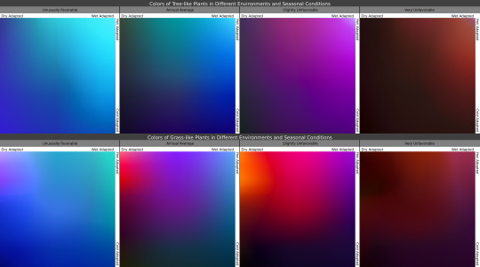
Once I knew where the plants belonged, I then determined what colors they'd be in the conditions they're adapted for, as seen in the maps, and under seasonal variation, with the chart showing how plants with certain adaptations react to seasonal changes in those conditions.

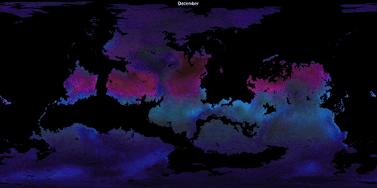
In these gifs we see the ground plants and tree canopies changing colors as the Solstices and Equinoxes expose them to greater or lesser rainfall and harsher or milder temperatures than what they're adapted for. Neither of these gifs provide a true image of what the surface looks like from space, but rather of the in-person appearance of whatever plants may be present.

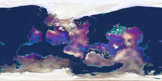
Finally, using the vegetation density maps as raster masks for the seasonal plant color maps, and layering those with the snow-and-ice maps over the soil color map, we now have a much truer image of Ayrum's surface as of its (Northern) Winter, Spring, Summer, and Autumn months.
#Ayrum#mapmaking#digital painting#imaginary maps#imaginary climate zone maps#Trewartha climate scheme#Koppen climage scheme#worldbuilding#commission#major project#seasonal data sequence#imaginary soil color maps#imaginary vegetation maps#vegetation extent#vegetation color#satellite-style maps#Photopea#Christopher Maida Artwork
49 notes
·
View notes
Text
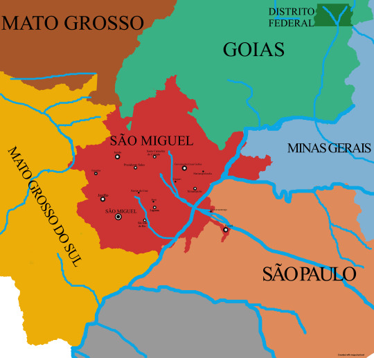
A Little map of the glorious state of São Miguel. Founded in 1895 by the great first governor Cesar Galles. Located between the southeast and the midwest of Brazil. The crown jewel of the Cerrado.
3 notes
·
View notes
Text
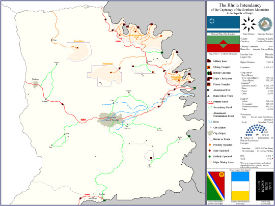
Southern Aspenia in 160 ACC

I'm trying out representing geographic features on my maps. But I feel like it looks a bit messy.
Most of Aspenia's territory is covered in a dry sandy desert, especially the section that was south of the Pelgriece Canyon. This region is harsh but has long served as an essential place for travellers to pass through. The desert was a better alternative to climbing through the Cethoks, over the surrounding highlands, and through the wilds of western Montethé.
The main trade route from northern Norphendra to the south of the continent was established through Aspenia and the Inpent Desert. The trail connected the dots between the oases of Clos Vin, Clos Mor, and the largest oasis at Clos Ein. But most importantly the route went over the Arch of Turrice, the only crossing point of the Pelgriece Canyon.
This trade corridor was the main factor behind Aspenia's earlier success and garnering of wealth. Some of the 12 ruling families can trace their origin of power to the beginning of the trade route.
Some of the features on the map:
Pelgriece Canyon: Largest canyon on Hessdalen.
Pelgrohve Mountains: A mountain range mostly situated in Mohvesto.
Cethok Mountains: The tallest mountain range on Hessdalen. Trecherous to pass through.
The Great Dunes of Rynnia: A section of the desert covered in immense sand dunes that form towering ridges of pure powdery sand.
Nevence Depression: A large section of the Inpent Desert that is below sea level. A former lake.
Other points:
Next to the Aspenian flag is the symbol of the ruling family of Clos Ein, the oasis city being the most important in the region (rivaling Turrice).
The red highlighted borders show Aspenia's border with the Cazkanian controlled regions.
Aspenia is located in the heart of Norphendra, Hessdalen's largest continent.
Aspenia was an important power in the Early Ages, and was a major rival of the great Rusovian Empire.
The Aspenian caste system is strict. 12 families rule the country, and have ruled it since its inception. The wealth divide between them and the bottom classes is gargantuan.
Later in the year of 160, Aspenia would be attacked by Cazkania in a conflict that became known as the Aspenian War. This war was impactful in many ways, especially for some of my characters. I'll make another post about the invasion and go into more detail on its impacts.
#worldbuilding#fantasy world#fictional world#writeblr#fictional history#fantasy maps#imaginary maps#imaginary world#cozar#hessdalen
10 notes
·
View notes
Text
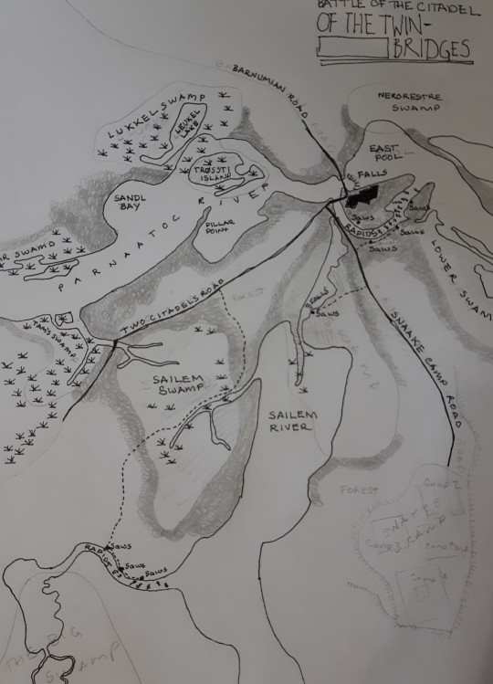
Pencil and pen on paper. Started 10 days ago, still in progress.
2 notes
·
View notes
Last Seen Blogs

jumpblog339
Untitled

angelinaflokis-sportsfreak
angelinaflokis-sports freak

qovefurag
Untitled

lenbaer61
Lenbaer

gr-to
Untitled