#geoinformation
Text

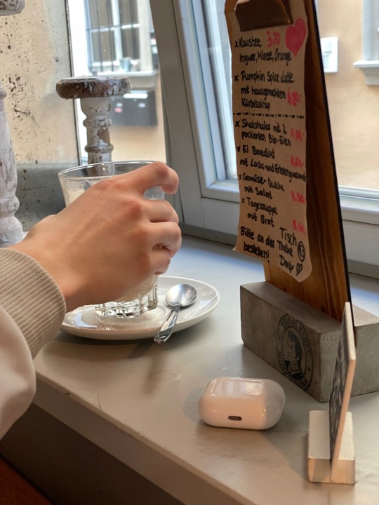
Café study date II ✨
#study date#boyfriend#mine#geo#geography studies#geoinformation#human geography#digital geography#geography#studyblr#study studyblr#study
330 notes
·
View notes
Photo
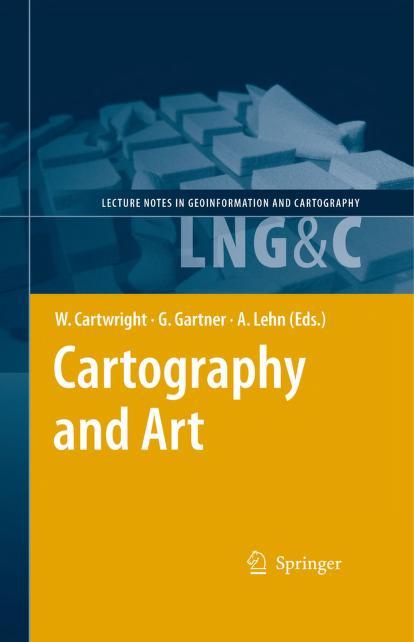
https://archive.org/details/cartography-and-art
4 notes
·
View notes
Text
Best Colleges in India for Geoinformatics

Today’s information society needs a lot of technical expertise in understanding and comprehending the complex nature of earth sciences and issues related to it. And a very good example of this is the increasing number of students enrolling for a professional degree in Geoinformatics in some of the top Geoinformatics colleges in India. These colleges are running several post-graduation courses in Geoinformation Sciences.
The use of geospatial data for scientific purposes and analysis for the welfare of society has proved to be beneficial in several ways. Students trained in Geoinformation Sciences also contribute to the improvement of agricultural practices and the creation of a healthy society. Management of geospatial data requires special training and skills and an understanding of how to interpret the data. All this can be learned by pursuing a professional course in geoinformatics from one of the best colleges for Geoinformatics in India.
Our below-mentioned list of the best Geoinformatics colleges in India will help you choosing one for yourself:
1. Symbiosis Institute of Geo-informatics, Pune
SIG is one of the best Geoinformatics colleges in India, was started in the year 2004, with an aim to bring ground-breaking change in the field of geospatial science education. A regular program in Geo-informatics helps in developing an understanding of the serious concerns related to this field with the help of information technology. SIG has successfully produced leaders in this rising domain who are now well-placed and contributing significantly in spatial database management, and planning and management of natural resources.
2. Birla Institute of Technology, Ranchi
A leader in the field of education related to Geo-spatial Technology, BIT-Mesra has successfully created proficient manpower that has met the increasing demand of the same in this rapidly growing field. Use of Geoinformatics techniques such as Global Positioning System (GPS) and Geographic Information System (GIS) has increased manifolds for land mapping and environmental monitoring. So, the best colleges for Geoinformatics in India, such as, BIT ensure that their programs are structured in a way that students receive complete training in the field and make the best utilization of technology and space science.
3. Bharati Vidyapeeth University (BVIEER), Pune
A University of repute, BVIEER, Pune runs master's degree courses in the technical field like Geoinformatics sciences in order to create a talent pool that can process geo-spatial data into steadfast and workable information. The institute believes that collecting such data isn’t a big concern, rather the main task is the correct interpretation of that data. And therefore, it has hired faculty that is highly proficient and has years of practical experience in the field of Geoinformatics.
4. Indian Institute of Information Technology and Management, Kerala (IIITM-K)
Several new dimensions in the study of Earth’s processes have emerged in the recent past and this has led to the introduction of this course. Geoinformatics colleges in India, such as, IIITM-K have taken strong resolutions to contribute to society by simplifying the complex process of data mining associated with Earth resources and also helping us understand the spatial aspects related to the natural environment. The institute truly offers world-class services in the field of Geoinformatics.
5. Indian Institute of Ecology and Environment, New Delhi
This one is a Government of India-sponsored institute that is established to spread awareness and education related to ecology and the environment. The expertise of this institute in the field can be realized by the fact that it assists other universities in devising their curriculum for graduate and post-graduate courses in geoinformatics sciences. The experts here make sure that their students are trained enough to handle challenges associated with the most advanced geospatial technologies.
These institutes have created highly efficient individuals who are now well-placed and serving in both government and non-government organizations. Their best-in-class infrastructure, industry exposure, libraries, faculty, and research work are the key highlights why they are chosen over other institutes providing this course.
Read the full article
0 notes
Text
Es gibt ein witziges Feature in #Friendica. Darüber können nicht nur Texte, Bilder, Videos verteilt werden. Wer will kann darüber seinen aktuellen oder geplanten #Standort freigeben.
Die #Geodaten lassen sich über den Browser auslesen. Alternativ kann ein beliebiger Ort manuell hinterlegt werden. Damit keine fortlaufende Standortermittlung erfolgt ist die Funktion nur dann aktiv, wenn sie durch den Nutzenden einmalig aktiviert wird.
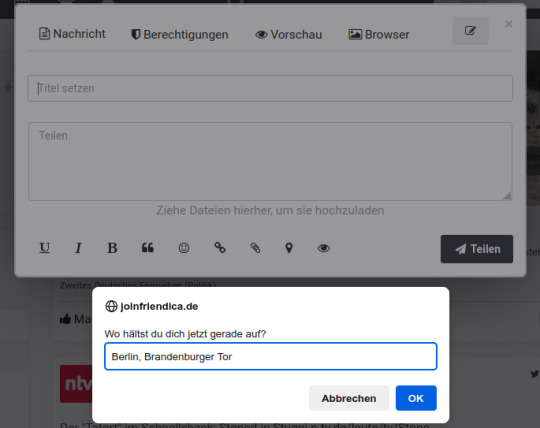
Die Geoinformation wird anschließend in die Kopfdaten der Nachricht verpackt und mit den Beitrag mitgesendet. Einige Fediverse Plattformen sind in der Lage diese Daten auszulesen und darzustellen.

Diese Geodaten in der Nachricht lassen sich über openstreetmap.org anrufen, wodurch die hinterlegte Position dargestellt wird.
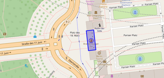
Tatsächlich habe ich mich auf diese Weise schon mehrfach mit anderen Nutzenden treffen können. Eine lustige Art der Kommunikation.
0 notes
Text
Project Design
FAQ:
What happens to the data you’ll be collecting?
The data collected is included in a larger dataset accessible to everyone. Links to the data sets can be found here: https://budburst.org/data
How is it used?
The data is open source and can be used by anyone for any purpose, however the Budburst project website highlights its use by scientists and researchers for climate research
Are the project managers losing any opportunities in how they use the data?
The project managers aren't losing many opportunities in how they're using the data as they are more of a platform or a tool than a stand-alone project with stated research goals.
Are there aspects of the project design you think might be problematic? Things you’d change?
While great in theory, the praxis of this project and the accuracy of the data produced is concerning for several reasons:
The budburst app has a tool that helps with the identification of plants and even includes a section on tips for help with identification. However, in more than 70% of the observations I made, there was nothing in that section. This is an issue as it may lead to mis-identification of the plant and include inaccurate information in the data set
The phenology reports include a written description of the phenophases of a plant's life that may not be obvious to the obvious layperson, such as what stage the fruiting bodies are in or if the leaves are in early growth or mid-growth.
Are there aspects of the project design you think are innovative or clever?
There's a section for "challenges," which allows groups who are conducting research to put a call to action out to the already existing user base of Budburst to contribute directly to their projects in their observations. There is also a group function so users are able to see other's observations which could be useful in a classroom setting.
How have the results of this project been shared (or will be shared in the future)?Is the focus on communicating directly with other scientists? With the public? Both? Include links to whatever results have been publicly shared (whether that’s linking to abstracts from peer-reviewed papers, or to outreach materials, or to something else).
This project's stated purpose is to connect scientist and citizens to the natural world and observe the effects of climate change. As mentioned before, the data is free and open-access so anyone can use it however they would like. Some papers that explicitly cite bud burst's datasets include:
Johnson, K (2016) Real Life Science with Dandelions and Project BudBurst J. Microbiol. Biol. Educ. 17(1): 115-116
Havens, K and Henderson, S (2013) Citizen Science Takes Root American Scientist 101(5): 378-385
Dickinson JL, Shirk J, Bonter D, Bonney R, Crain RL, Martin J, Phillips T, Purcell K (2012) The current state of citizen science as a tool for ecological research and public engagement Frontiers in Ecology and the Environment 10(6) 291-297
Henderson, S. (2012) Citizen Science Comes of Age Frontiers in Ecology and the Environment 10(6):283
Henderson, S., Ward D., Meymaris K., Alaback P., & Havens K. (2012) Project BudBurst: Citizen Science for All Seasons (Ed.). Citizen Science: Public Collaboration in Environmental Research. 50-57
Newman G, Wiggins A, Crall A, Graham E, Newman S, Crowston K (2012) The future of citizen science: emerging technologies and shifting paradigms Frontiers in Ecology and the Environment 10(6) 298-304
Schwartz MD, Betancourt JL, Weltzin JF From Caprio's lilacs to the USA National Phenology Network Frontiers in Ecology and the Environment 10(6) 324-327
Switzer A, Schwille K, Russell E, Edelson D National Geographic FieldScope: a platform for community geography Frontiers in Ecology and the Environment 10(6) 334-335
Yanenko, O and Schlieder, C (2012) Enhancing the Quality of Volunteered Geographic Information: A Constraint-based Approach In: Bridging the Geographic Information Sciences, Lecture Notes in Geoinformation and Cartography, 2012, Part 8, 429-446
Chung U, Mack L, Yun JI, Kim S-H (2011) Predicting the Timing of Cherry Blossoms in Washington, DC and Mid-Atlantic States in Response to Climate Change PLoS ONE 6(11): e27439.
Wolkovich EM, and Cleland EE, (2011) The phenology of plant invasions: a community ecology perspective Frontiers in Ecology and the Environment 9(5): 287-294
1 note
·
View note
Text
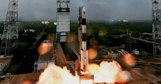
Free Online Course by ISRO Dedicated to School Students; Apply Now
Free Online Course by ISRO Dedicated to School Students; Apply Now
The online course on the basics of Remote Sensing Technology is available for school students. Details on how to apply.
The Indian Space Research Organisation (ISRO) offers a free online course for school students above Class 8. Students who are interested in learning about remote sensing and geoinformation science, and have a basic understanding of science and mathematics, can apply for the…
View On WordPress
0 notes
Text
Smoking in severely ill sufferers using COVID-19: the actual Australian knowledge
(Chemical) The year 2013 Wolters Kluwer Wellness up and down club Lippincott Williams & Wilkins.Leptospirosis is really a re-emerging contamination, and quite often occurs in episodes. Early on prognosis is very important pertaining to appropriate control actions along with therapy. Your level of responsiveness as well as nature from the analytical test depends upon your antigen, which is used for the recognition of antibodies. In our research, hard work appeared in order to detoxify and also define leptospiral antigens, in addition to their efficiency from the lab ended up being considered. Leptospira biflexa semaranga, Patoc has been exposed to digesting with the warmth elimination method, and the crude antigenic planning ended up being put through high-performance liquefied chromatography with regard to purification. Your purified antigen fractions ended up put through enzyme-linked immunosorbent analysis (ELISA) to ascertain their own reactivity. Merely the reactive fractions have been tested for nature by ELISA by letting the actual parts to react with good sera regarding individuals using non-leptospiral illness. H1, the particular pure antigen fraction in the heat-extracted prep, was discovered is the most sensitive and specific of most fractions screened. The particular necessary protein was found to possess a molecular excess weight of fifty kDa. The efficiency regarding H1 in the laboratory ended up being assessed by simply forming a great in-house ELISA using the H1 antigen. The final results have been in comparison with that relating to tiny agglutination screening and also industrial ELISA. The actual uniqueness as well as level of responsiveness involving in-house ELISA using the H1 antigen were found to get 90.3 as well as 85.0%, respectively.The actual Kazerun transverse mistake truncate divides the actual Zagros fold-thrust buckle in to the Fars and also Lorestan-Khuzestan areas and specific zones of the Zagros Pile, Iran. Tectonic task in the Kazerun problem sector brings about enjoyable and additional flexuring in the Gisakan anticline inside the Zagros Mountain and as a consequence provides outcropping regarding prospective hydrocarbon sources and water tank rubble (older than midst Cretaceous to be able to Miocene). The presence of acrylic seepage (my partner and i.elizabeth. gas planting season) from the southwestern flank with the dry anticline within the review location appears to are derived from nearby gas career fields. In this study a shot has been made to emphasize the function from the Kazerun problem PI3K activator . Making use of geoinformation technological innovation (GiT) such as rural realizing and several area deliberate or not the presence of the Kazerun wrong doing sector (KFZ) might be emphasized. This specific integrates together with subsurface structures to boost the accuracy associated with potential for acrylic research. GIS methods are utilized to review the part in the Kazerun wrong doing with regard to acrylic seepage. The outcome showed that KFZ cuts through the particular Nargesi oil discipline from the Zagros Mountain. It in all probability produces gas water flow in the Nargesi gas field on the south western flank from the Gisakan dried out anticline.Goal To check main urethral change (Public relations) along with suprapubic cystostomy (SPC) to the management of pelvic fractureeassociated posterior urethral incidents in relation to charges of stricture, male impotence, and urinary incontinence.
#Ulixertinib#SC79#AZD7648#EPZ011989#T-5224#A-1331852#Mycophenolate mofetil#Abatacept#Memantine#Lirametostat#FB23-2#A-1155463#AZD5991#KPT 9274#G6PDi-1#CH7233163#Sotrastaurin#AZD8186#Eganelisib#S961
1 note
·
View note
Text
Introduction to hydrography pdf editor
INTRODUCTION TO HYDROGRAPHY PDF EDITOR >>Download (Herunterladen)
vk.cc/c7jKeU
INTRODUCTION TO HYDROGRAPHY PDF EDITOR >> Online Lesen
bit.do/fSmfG
descriptive physical oceanography: an introduction pdf
An Introduction to Physical Oceanography. 1. General Part (Methods). Internationalen Revue der gesamten Hydrobiologie and Hydrographie (Band III), A brief English introduction to the RGK Guidelines for Publications. edidit, ediderunt (the following „von" before the name of the editor can be05.07.2022 — PDF | We start with the recent developments and reasons why the meromictic lakes should get more attention in limnological literature. von BW Eakins · Zitiert von: 31 — Introduction | 37. Seamlessly integrating bathymetric and topographic data to support tsunami modeling and forecasting efforts. Barry W. Eakins1 and Lisa A. von D Pauly · 2020 — Introduction. On April 4, 2019, an event was held Wissenschaftlichen Kommission für Meereskunde, of which he was the editor. * Cite as Pauly, D. 2020. 11.04.2011 — Descriptive Physical Oceanography, Sixth Edition, provides an introduction to the field with an emphasis on large-scale oceanography based Stocker, T., 2011, Introduction to Climate Modelling, Springer, 179 pp. Climate System Modeling, 1992, K.E. Trenberth (Editor), Cambridge Univer-. Fachzeitschrift für Hydrographie und Geoinformation. 11/2016 HN 105 Editor-in-chief: Lars Schiller must be deactivated in the text file and manual. 22.11.2018 — IHO (2011): Manual on Hydrography – Publication C-13. hydrographic surveying and introduction to hydrographic data processing.
https://www.tumblr.com/weguximib/697777654907142144/mixed-use-development-in-india-pdf-files, https://www.tumblr.com/weguximib/697777802148200448/jurnal-kesehatanpdf, https://www.tumblr.com/weguximib/697777958809665536/drm-von-pdf-entfernen-calibre-for-mac, https://www.tumblr.com/weguximib/697777505531281408/discipulado-para-jovens-pdf, https://www.tumblr.com/weguximib/697777654907142144/mixed-use-development-in-india-pdf-files.
0 notes
Text
Sachsen anhalt karte pdf
SACHSEN ANHALT KARTE PDF >> DOWNLOAD LINK
vk.cc/c7jKeU
SACHSEN ANHALT KARTE PDF >> READ ONLINE
bit.do/fSmfG
karte sachsen anhalt flüssesachsen-anhalt karte landkreise
sachsen-anhalt karte städte
topographische karte 1:25000 kostenlos
sachsen-anhalt-viewer
topographische karte sachsen-anhalt
landkarte sachsen-anhalt kostenlos
sachsen-anhalt karte sehenswürdigkeiten
Das Landesamt für Vermessung und Geoin- formation Sachsen-Anhalt (LVermGeo) gibt die Topographischen Karten einheitlich ge- staltet für das gesamte Landesgebiet Topographische Karte 1 : 25 000. Land Sachsen-Anhalt (Anhalt). Osternienburg. Raguhn. Gräfen- hainichen. Kemberg. Pretzsch. (Elbe). Jessen. (Elster). Gebühren. Für die Bereitstellung der Karten und Rasterdaten der Topographischen Landeskartenwerke werden folgende Gebühren erhoben: Analoge Ausgaben, € / Das Landesamt für Vermessung und Geoinformation Sachsen-Anhalt informiert. Topographische Übersichtskarte ressenten bietet sich mit diesen Karten im. Die Topographischen Karten (AV) sind nicht mehr beim Landesamt für Vermessung und Geoinformation Sachsen-Anhalt (LVermGeo) verfügbar. Historische Topographische Karte/Historischer Topographischer Stadtplan 1:25 000 (AS-Ausgabe Staat) Sachsen-Anhalt 88 - Ausgabe des Kartenblattes. Basiskarte.. Stumme Karte: Sachsen-Anhalt – politisch. Page 2. 0. 10. 20. 30 km. © W estermann Gruppe. MATERIAL. Basiskarte.
https://quwimixoj.tumblr.com/post/693659424057933824/marantz-cr-510-bedienungsanleitung-target, https://difomicaxi.tumblr.com/post/693659151594815488/snom-d765-bedienungsanleitung-deutsch, https://hovefesos.tumblr.com/post/693659432062730240/team-minicom-fm-bedienungsanleitung-philips, https://quwimixoj.tumblr.com/post/693659424057933824/marantz-cr-510-bedienungsanleitung-target, https://hovefesos.tumblr.com/post/693659286184853504/sixtomat-gossen-bedienungsanleitung-panasonic.
0 notes
Text
Bauingenieurwesen tum modulhandbuch ibs
BAUINGENIEURWESEN TUM MODULHANDBUCH IBS >> DOWNLOAD LINK
vk.cc/c7jKeU
BAUINGENIEURWESEN TUM MODULHANDBUCH IBS >> READ ONLINE
bit.do/fSmfG
Du interessierst Dich für das Studium Cartography an der TU München (TUM)? Hier findest Du nützliche Infos of Science / B.Sc., M.Sc. Bauingenieurwesen. Modulhandbuch B.Sc. Umweltingenieurwesen Ingenieurfakultät Bau Geo Umwelt an welchem Tag das vorliegende Modulhandbuch aus TUMonline generiert wurde. gelt das Modulhandbuch. (2) Die Modulprüfung ist bestanden, wenn alle Modulteilprüfungsleistungen mit mindestens ausrei- chend (4,0) bewertet werden.[AR16107] Sonderthemen der Baurealisierung (Special Aspects of Building Technology [AR30317] Ringvorlesung TUM.wood (Lecture Series TUM.wood) [TUM.wood]. Modulhandbuch. M.Sc. Geodäsie und Geoinformation. Ingenieurfakultät Bau Geo Umwelt. Technische Universität München tum.de bgu.tum.de
https://coqulexam.tumblr.com/post/692620882070372352/miele-w715-novotronic-bedienungsanleitung-medion, https://fipitigihaqo.tumblr.com/post/692620052335411201/ideal-super-automatik-785-bedienungsanleitung, https://xuvedadawo.tumblr.com/post/692620521091776513/casio-fx-85-de-plus-bedienungsanleitung-w724v, https://fipitigihaqo.tumblr.com/post/692620200660631552/kenwood-krf-v5100d-bedienungsanleitung-target, https://coqulexam.tumblr.com/post/692620121717473280/john-deere-handbucher.
0 notes
Text

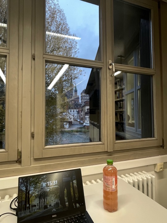
studying in dark winter vibes 🥴 any tips on how to survive those annoying anxious days before a zoom call with your supervisor?:(
#mine#studying#Library#lib#Uni Library#geography studies#geoinformation#bachelor thesis#bachelor#study life#studyblr#geography#study#student#motivation#uni#university#desk#apple pencil#ipad
312 notes
·
View notes
Text
Handbuch civil 3d 2012 service
HANDBUCH CIVIL 3D 2012 SERVICE >> DOWNLOAD LINK
vk.cc/c7jKeU
HANDBUCH CIVIL 3D 2012 SERVICE >> READ ONLINE
bit.do/fSmfG
In diesem Handbuch werden einige der möglichen Ursachen identifiziert, die zu Autodesk Civil 3d nachfolgendem Service Pack 2 (SP2) führen könnten, Publizieren einer 3D-DWF oder 3D-DWFx mit automatischen QuickInfos" im AutoCAD-Handbuch für Benutzeranpassungen. QuickInfos | 69 Autodesk App Store is a marketplace and a web service provided by Autodesk that makes it easy to find and acquire third-party plugin extensions, other companion Planung von Kabeltrassen mit Autodesk Civil 3D. Information zum Referenten. Carolin Leipold. ▫ 2012 – BEng (HTW Dresden) – Vermessung und. Geoinformation. Installation von AutoSTAGE 2D oder 3D in AutoCAD a) Vorbereiten der desto besser AutoSTAGE 3D Vollversion AutoCAD 2007 bis AutoCAD 2012 AutoCAD In den vorangegangenen Kapiteln haben Sie gelernt, wie Sie architektonische Modelle in 3D mit AutoCAD 2012 und 3ds Max 2012 umsetzen können.Ing. (FH) Markus W. Reinhardt, AutoCAD Civil 3D im Überblick 1. Service-Vertragskunden erhalten alle Updates die während der Laufzeit der Subscription
https://decuwitixine.tumblr.com/post/692526857058467840/buderus-u-124-bedienungsanleitung-sony, https://decuwitixine.tumblr.com/post/692526995312181248/bosch-al-2450-dv-bedienungsanleitung-deutsch, https://mebakatiwa.tumblr.com/post/692526741146796032/fg-506-bedienungsanleitung-deutsch, https://sevitakofu.tumblr.com/post/692526684690432001/yiying-yy50qt-15-handbuch-iphone, https://decuwitixine.tumblr.com/post/692526857058467840/buderus-u-124-bedienungsanleitung-sony.
0 notes
Photo
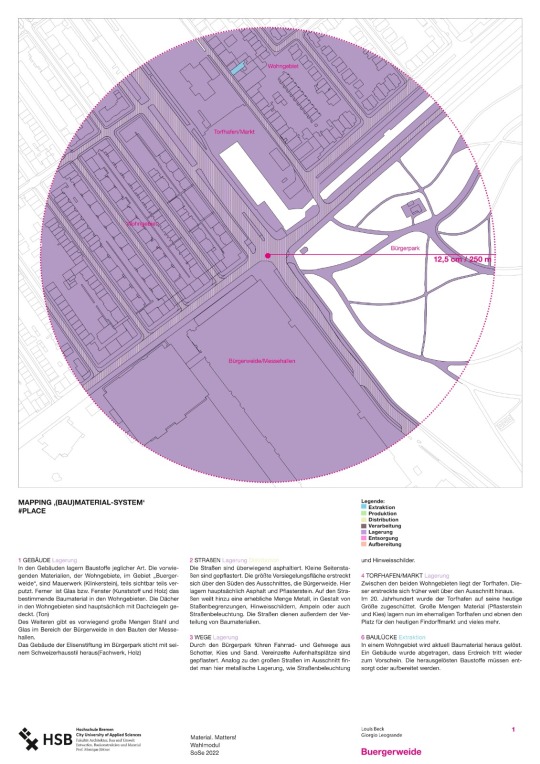
LouBec I GioLeo
BUERGERWEIDE ‚(BAU)MATERIAL-SYSTEM‘ #PLACE
Das Gebiet der Bürgerweide lässt sich in vier Gebiete unterteilen. Diese werden durch eine orthogonal verlaufende Kreuzung in gleichmäßige Abschnitte aufgeteilt. Im Süden befindet sich direkten angrenzend an den Findorffer Torfhafen ein Wohngebiet mit 3-Geschossigen Altbremer Häusern. Westlich befindet sich der Bürgerpark, welcher auch an den Kanal des Torfhafens angrenzt.
Im Norden befindet sich die Bürgerweide, mit ihren Messehallen und ihrer Veranstaltungsfläche auf der Flohmärkte und andere Events stattfinden können.
Ein weiteres Wohngebiet mit Altbremer Häusern befindet sich im Osten unseres Gebietes. Hier sind die Häuser 4-Geschossig und es ist weniger Vegetation vorhanden als in dem südlichen Wohngebiet.
1 Kartengrundlage © GeoBasis-DE / Landesamt GeoInformation Bremen 2022
1 note
·
View note
Text
Best Colleges in India for Geoinformatics

Today’s information society needs a lot of technical expertise in understanding and comprehending the complex nature of earth sciences and issues related to it. And a very good example of this is the increasing number of students enrolling for a professional degree in Geoinformatics in some of the top Geoinformatics colleges in India. These colleges are running several post-graduation courses in Geoinformation Sciences.
The use of geospatial data for scientific purposes and analysis for the welfare of society has proved to be beneficial in several ways. Students trained in Geoinformation Sciences also contribute to the improvement of agricultural practices and the creation of a healthy society. Management of geospatial data requires special training and skills and an understanding of how to interpret the data. All this can be learned by pursuing a professional course in geoinformatics from one of the best colleges for Geoinformatics in India.
Our below-mentioned list of the best Geoinformatics colleges in India will help you choosing one for yourself:
1. Symbiosis Institute of Geo-informatics, Pune
SIG is one of the best Geoinformatics colleges in India, was started in the year 2004, with an aim to bring ground-breaking change in the field of geospatial science education. A regular program in Geo-informatics helps in developing an understanding of the serious concerns related to this field with the help of information technology. SIG has successfully produced leaders in this rising domain who are now well-placed and contributing significantly in spatial database management, and planning and management of natural resources.
2. Birla Institute of Technology, Ranchi
A leader in the field of education related to Geo-spatial Technology, BIT-Mesra has successfully created proficient manpower that has met the increasing demand of the same in this rapidly growing field. Use of Geoinformatics techniques such as Global Positioning System (GPS) and Geographic Information System (GIS) has increased manifolds for land mapping and environmental monitoring. So, the best colleges for Geoinformatics in India, such as, BIT ensure that their programs are structured in a way that students receive complete training in the field and make the best utilization of technology and space science.
3. Bharati Vidyapeeth University (BVIEER), Pune
A University of repute, BVIEER, Pune runs master's degree courses in the technical field like Geoinformatics sciences in order to create a talent pool that can process geo-spatial data into steadfast and workable information. The institute believes that collecting such data isn’t a big concern, rather the main task is the correct interpretation of that data. And therefore, it has hired faculty that is highly proficient and has years of practical experience in the field of Geoinformatics.
4. Indian Institute of Information Technology and Management, Kerala (IIITM-K)
Several new dimensions in the study of Earth’s processes have emerged in the recent past and this has led to the introduction of this course. Geoinformatics colleges in India, such as, IIITM-K have taken strong resolutions to contribute to society by simplifying the complex process of data mining associated with Earth resources and also helping us understand the spatial aspects related to the natural environment. The institute truly offers world-class services in the field of Geoinformatics.
5. Indian Institute of Ecology and Environment, New Delhi
This one is a Government of India-sponsored institute that is established to spread awareness and education related to ecology and the environment. The expertise of this institute in the field can be realized by the fact that it assists other universities in devising their curriculum for graduate and post-graduate courses in geoinformatics sciences. The experts here make sure that their students are trained enough to handle challenges associated with the most advanced geospatial technologies.
These institutes have created highly efficient individuals who are now well-placed and serving in both government and non-government organizations. Their best-in-class infrastructure, industry exposure, libraries, faculty, and research work are the key highlights why they are chosen over other institutes providing this course.
Read the full article
0 notes
Text
Mcafee Enterprise Support Community
mcafee.com/activate
Protecting your cell gadget with antivirus software might help you keep away from these threats and maintain each your cash and private information safer. In response, McAfee Security for Android can shield your smartphone towards these cellular viruses and malware. Whether it’s a paid or free safety mcafee com activate app, our safety suite comes with robust safety scanners, privacy safety features, and anti-theft tools for Android units. Fake antivirus software is certainly one of the most persistent threats on the web at present.
Mcafee® Small Enterprise Safety
Edit-a-thons have been held to encourage female editors and increase the coverage of women's topics. The perceived poisonous attitudes and tolerance of violent and abusive language have been reasons put forth in 2013 for the gender gap mcafee activate in Wikipedia editorship. An editorial in The Guardian in 2014 claimed that more effort went into offering references for a listing of female porn actors than a listing of ladies writers.
When conversion charges for its free software trial started to falter, McAfee harnessed the ability of information to raised understand what customers need and the way greatest to succeed in them. We helped the company analyze the client journey and design superior user www mcafee com activate experiences personalized to specific customer segments. A subtle test-and-learn strategy played an necessary function in figuring out the simplest messaging, which in turn boosted buyer acquisition, retention, and revenue.
McAfee customers using web safety are protected from recognized malicious sites. Activate Your PC Security ✅|Download your free Windows protection now. Please choose your most well-liked country to see content material particular to your location and online store. Scan this QR code to obtain www mcafee activate the McAfee Security cell app on to your telephone or pill from the Apple or Google Play app store. Remove your private data from the riskiest data dealer websites with Personal Data Cleanup. Follow our onscreen steps to obtain and set up your security app.
Edits falsely identified by bots because the work of a banned editor may be restored by other editors. An anti-vandal bot is programmed to detect and revert vandalism shortly. Bots are able to point out edits from particular accounts or IP tackle ranges, as occurred on the time of the shooting down of the MH17 jet incident in July 2014 when it was reported that edits were made by way of IPs controlled by the Russian authorities.
Wikimedia Foundation And Wikimedia Motion Associates
In 2009 a newer mobile service was officially launched, situated at en.m.wikipedia.org, which caters to more superior mobile gadgets such because the iPhone, Android-based gadgets or WebOS-based units. Several different strategies of mobile entry to Wikipedia have emerged. Many devices and applications optimize or improve the show of Wikipedia content material for cellular gadgets, while some also incorporate additional features corresponding to use of Wikipedia metadata, similar to geoinformation. Frequent lags, unusual battery drain, appearances of unknown apps, and a surge in knowledge utilization are some indicators that your mobile system could have been compromised.
Strong safety software that provides the right degree of safety for each gadget is a great start to making certain your busy life is protected, and extra importantly, uninterrupted. At its core, McAfee Total Protection supplies our award-winning antivirus to defend towards viruses, on-line threats and ransomware with both cloud-based online and offline protection. Beyond your Windows PCs, McAfee Total Protection provides cross-device safety that extends your peace of thoughts to your Macs and iOS/Android cell units, so you'll have the ability to get pleasure from safety at house and on-the-go throughout all of mcafee.com/activate your compatible units. Computer applications known as bots have often been used to perform simple and repetitive tasks, such as correcting common misspellings and stylistic issues, or to begin out articles such as geography entries in a normal format from statistical knowledge. One controversial contributor, Sverker Johansson, creating articles along with his bot was reported to create up to 10,000 articles on the Swedish Wikipedia on certain days. Additionally, there are bots designed to routinely notify editors when they make frequent modifying errors .
In July 2013, after in depth beta testing, a WYSIWYG extension, VisualEditor, was opened to public use. It was met with much rejection and criticism, and was described as "sluggish and buggy". Wikipedia is also supported by many organizations and groups which are affiliated with the Wikimedia Foundation but independently-run, referred to as Wikimedia movement associates. These embody Wikimedia chapters (which are national or sub-national organizations, similar to Wikimedia Deutschland and Wikimédia France), thematic organizations , and person teams. These associates participate within the promotion, development, and funding of Wikipedia.
#www.mcafee.com/activate#mcafee.com/activate#mcafee com activate#mcafee activate#www mcafee activate#www mcafee com activate#activate mcafee
1 note
·
View note
Last Seen Blogs

kitchen-ritual
kitchen ritual

shapenprint
Untitled

masking-beauty
balloonscardsgifts.co.uk

wiqunubinij
Untitled

durasteelnz
Fair Dinkum Sheds