#PCT
Text

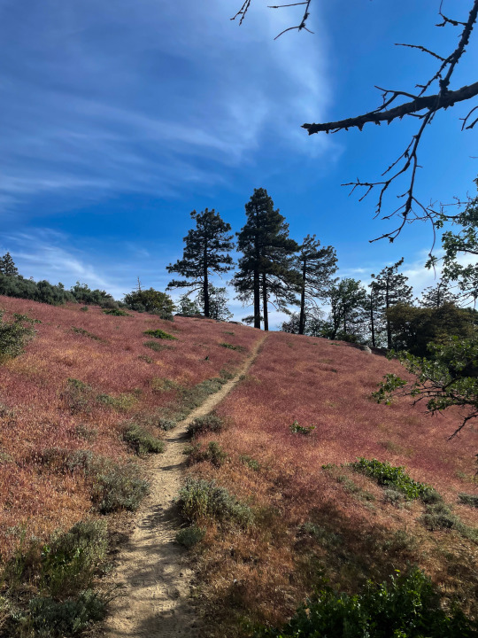
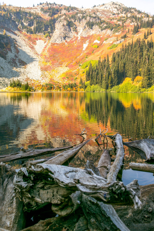
Cutthroat Pass Trail, Washington
#artists on tumblr#original photography#original photographers#pnw#nikon#orofeaiel#washington#hiking#lensblr#nature#moody#dark#forest#pacific northwest#pct#cutthroat pass#landscape#evergreens
162 notes
·
View notes
Text
"Have you ever read Wild?"
Okay this is a question I got all the time when I told anyone that I was hiking the Pacific Crest Trail. And the answer is yes. I also saw a Tik Tok on how to annoy thru-hikers and this question was on the list lol
Well I personally don't mind the question and I bring up this book now because this next part is where Cheryl Strayed began her journey on the PCT. From Mojave/Tehachapi to Kennedy Meadows. This stretch lasts for roughly 150 miles and it took me about 6 days to complete.
After my well earned rest in Tehachapi, I headed back out on the trail to go through one of the most beautiful sections of the trail so far.
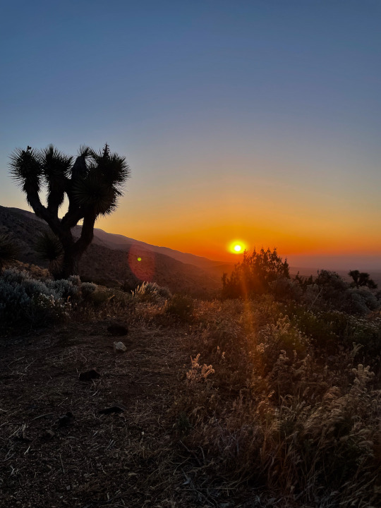
This is the foothills of the Sierra so naturally, the terrain changes into a more lush landscape and we began to gain some elevation. The campsites between Tehachapi and Kennedy Meadows were all stunning and at night I could see SO MANY STARS it was unreal.
I also need to note that the water carry out of Tehachapi was the longest by far! I want to say it was close to 40 miles? but don't quote me on this. I was very mindful of my water consumption in this part and hiked FAST trying to catch up to some hikers who left a day before me.
I also want to note I cried the most on this stretch of the trail. Not because of sadness but more so because I was in awe of my surroundings and felt surreal and blessed. This is definitely why I love to be outdoors immersed in nature. The sheer magnitude and beauty of the landscape evokes a certain feeling in you (◕‿◕✿)
^That was where I bawled lol
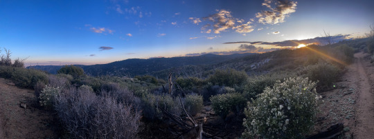
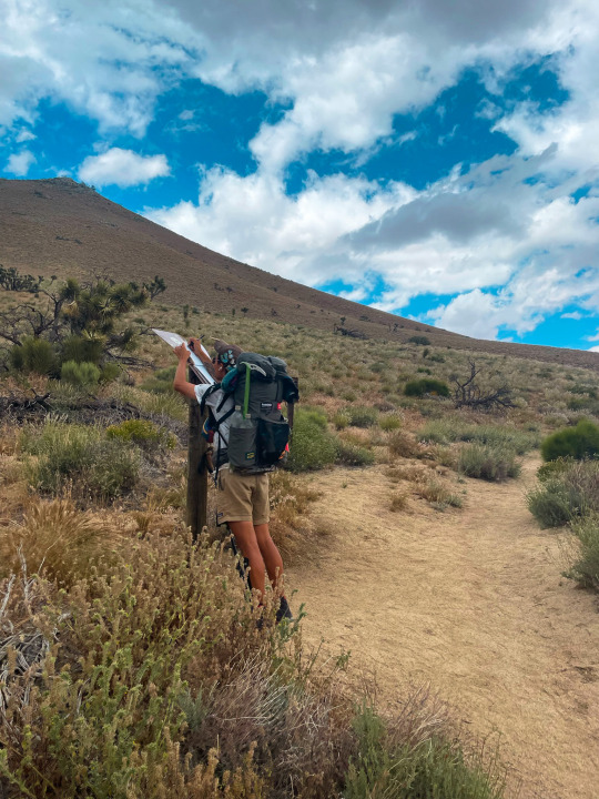
Anyways, I was able to catch up to my fellow hiker Strider in the next stretch and I made it to Walker Pass. We hitched a ride into Ridgewood and stocked up on some supply to push to Kennedy Meadows!
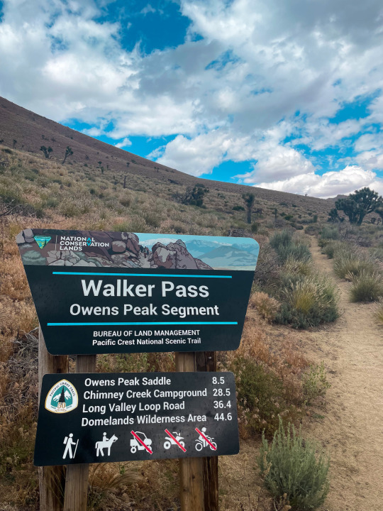
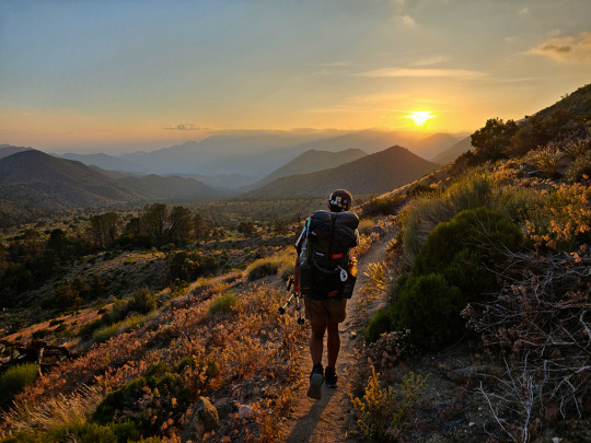
Fast forwarding a little bit, this next section was very hilly and I witnessed some of the most striking sunsets here. I can't stop recalling how beautiful it was and I keep thinking I need to use the word "beautiful" a bit less lol
Push Push Push
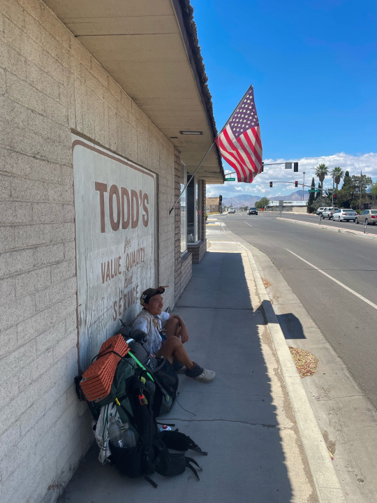
And there I was, in Kennedy Meadows!
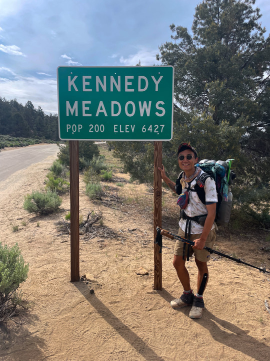
Aw man, you wouldn't believe what I felt there. PURE ECSTASY
The fact that I had hiked 700 miles was mindblowing and seeing others who had walked the same journey melded a sense of solidarity and unity in this community.
The common topic of this hiker haven was where to go next. Because of the high snow fall in the Sierras, many decided to bypass and go up north. As for my trail family, we decided to head up to Mammoth Lakes to go skiing for a day and jump up north.
As for me, I had decided to get off the trail to attend Electric Forest and skip up to the Canadian border to hike down lol In retrospect, this was not a good decision.. but I have no regrets! I'll try to talk more about this process in the next post \(*T▽T*)/
34 notes
·
View notes
Text

This image was captured on Squaw Valley Creek in Siskiyou County, California, USA. I captured the image on a somewhat overcast afternoon and really liked the soft ethereal light as the sun was filtered through the clouds. This part of the creek, just below the confluence of a small stream known as Cabin Creek, is especially beautiful. The famed Pacific Crest Trail (PCT) crosses just a short distance downstream from where this was captured. The small town of McCloud is just a few miles away and the whole area sits at the base of the majestic Mount Shasta, the fifth highest peak in the state of California.
In my Etsy shop: https://buff.ly/3V69dKf
Prints and merch on demand: https://buff.ly/47bZ7tT
#original photographers#original photographic works#photographers on tumblr#northern california#original photography on tumblr#siskiyou county#pct#pacific crest trail#hiking photography#springisonitsway#spring is just around the corner#springtime
18 notes
·
View notes
Text

It’s Tell a Friend Friday!
Please enjoy this photo I took of Wy'east (Mt. Hood) a few years ago on a backpacking trip on Section G of the Pacific Crest Trail.
Then tell someone you know about my work–you can reblog this post, or send it to someone you think may be interested in my natural history writing, classes, and tours, as well as my upcoming book, The Everyday Naturalist. Here’s where I can be found online:
Website - http://www.rebeccalexa.com
Rebecca Lexa, Naturalist Facebook Page – https://www.facebook.com/rebeccalexanaturalist
Tumblr Profile – http://rebeccathenaturalist.tumblr.com
BlueSky Profile - https://bsky.app/profile/rebeccanaturalist.bsky.social
Twitter Profile – http://www.twitter.com/rebecca_lexa
Instagram Profile – https://www.instagram.com/rebeccathenaturalist/
LinkedIn Profile – http://www.linkedin.com/in/rebeccalexanaturalist
iNaturalist Profile – https://www.inaturalist.org/people/rebeccalexa
Finally, if you like what I’m doing here, you can give me a tip at http://ko-fi.com/rebeccathenaturalist
#Wy'east#Mt. Hood#Oregon#Pacific Northwest#PNW#backpacking#through hiking#hiking#nature#nature photography#mountain#Cascade Mountains#landscape#landscape photography#Tell a Friend Friday#volcano#geology#PCT#Pacific Crest Trail
20 notes
·
View notes
Text

View inEarly Summer From PCT north of Snoqualmie Pass, Washington, 2003.
#landscape#mountains#forest#hiking trail#pacific crest trail#pct#washington state#2003#photographers on tumblr#pnw#pacific northwest
19 notes
·
View notes
Text
Y'ALL GUESS WHO'S NOW A COMMUNITY COLLEGE STUDENT?!?!?!?!
🎊 ME! 🥳
I'm going to become a certified Patient Care Technician! I'm so excited!!
#🎶 I'm so excited; and i just can't hide it! 🎶#I have a class schedule and everything!! 😁😁😁#community college#college#certification program#future patient care technician#future pct#patient care technician#pct#patient care#healthcare#healthcare careers#student#college student
10 notes
·
View notes
Text

Somewhere in the High Sierra on June 19, 2022
#mountains#hiking#backpacking#trekking#pacific crest trail#pct#john muir trail#jmt#high sierra#sierra nevada#photography#shot on iphone
25 notes
·
View notes
Text
Maple Pass
October 2022
View On WordPress
27 notes
·
View notes
Text
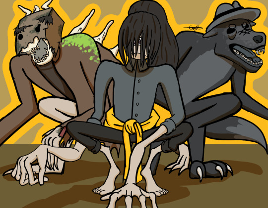
@neko-chan-13 @remadra LN monster solidarity >:3
#this was a quick lil sketch but it came out really nice imo#I LOVE OUR FUNKY LEETLE AUS SO MUCH!!! HOLDING HANDS AND GOING YIPPEE YIPPEE YIPPEE RN#snorlarts#friend stuff#sketches#monster!mono#monster six#werewolf!thinman#tbiot#pct#a wyrd of wisdom#awow#mono ln#six ln#the thin man#little nightmares
52 notes
·
View notes
Text
Hey folks! My name is Dan and I used to work for Tumblr. I quit my job about 10 days ago to prepare and commit myself to a long distance thru hike. Welcome to my hiking Tumblr 🎉🎉🎉
Here we go! It's T minus 4 days until the beginning of my Pacific Crest Trail thru hike. I will be blogging and documenting my journey on the trail. I suppose I will try to publish my posts every time I go into a trail town.
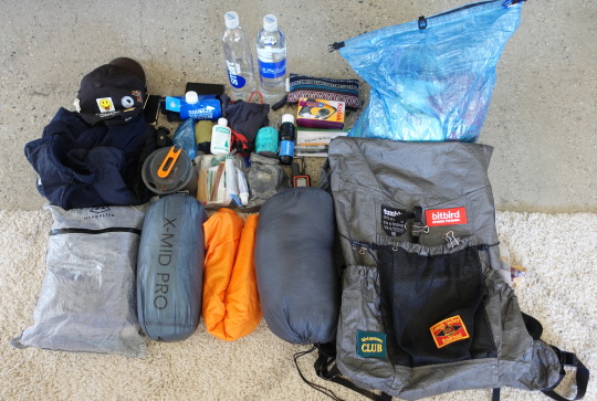
Gear List
Let's break down the gear I will be starting with!
Big 3 (pack, shelter, sleeping bag)
Durston Kakwa 40 - I will be carrying a 40L backpack this time. I've added some patches with fabric glue to personalize it a little bit (◕‿◕✿)
Enlightened Equiptment Enigma 20F Quilt
Durston Gears X-Mid Pro 1 - best lightweight trekking pole tents imo
Sleeping Pad - Klymit Insulated V UL SL
Water Filtration
Smart Water Bottle 1L x 4
Sawyer Squeeze <3
Kitchen
Jetboil Stash
Fuel Cannister
Utensils
Bic lighter
Toiletries
Nail Clipper
Wet Wipes
Toothbrush/Toothpaste
Sunscreen
Chafing Balm
Trowel
Lip Balm
First Aid Kit/Duct Tape/Meds
Clothing
Smart Wool Socks x 2
Arcteryx Synthetic
Arcteryx Atom Shell
Patagonia Wind Pants
Leggings
Baseball Cap
Underwear x 2
Hiking Shorts
Patagonia Sun Hoodie
T-shirt x 2
STUFF
Apple EarPods
iPhone 11 Pro
Garmin Inreach Mini 2 - satellite transmitter
Nitecore UL Headlamp
Nitecore UL 10000 mAh Powerbank x 2
Sony ZV-1 & UL tripod
Journal & Pen
UL Sea2Summit Pillow
Bug Net
Microspikes
There may be a few I'm leaving out of this list but ^ gives you a general sense of what I will be carrying. Here's also a link to my lighter pack
Base weight is currently just under 14 lbs! As reference, I am 5'7 130 lbs
Section 1: Southern California
The Southern Californian portion of the trail is dominated by desert landscapes with a few mountain passes. Socal saw record snow fall this year so I hope water resupply in this section won't be as big of an issue!
The following are all the trail towns I will be visiting in this section. For the sake of simplicity, all trail towns up to Kennedy Meadows South or KMS will be part of socal.
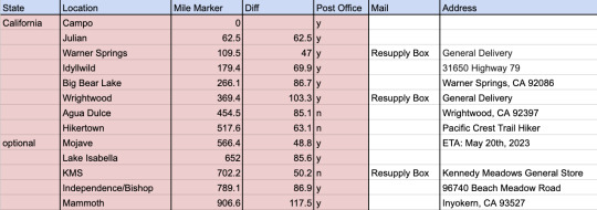
My friends back in NYC will be sending me resupply packages as I go. Currently, I'm reading Pacific Crest Trials which I am finding to be very interesting in terms of mental preparation for the thru hike.
My friend Kevin will be driving me down to Campo, the southern terminus of the trail on the 29th!
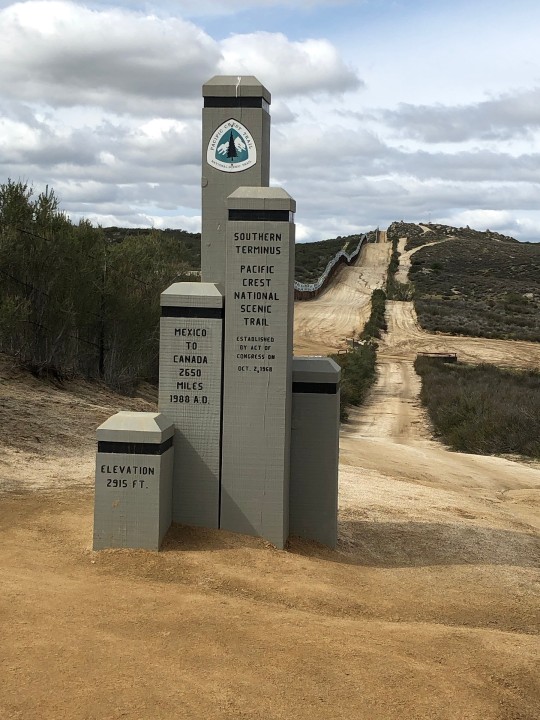
I'm feeling pretty good about this and as prepared as I can be!!! I also reached out to a manufacturer to make pins I could give out to fellow hikers on the trail. I've learned from music festivals that pins are a great way to make friends :3
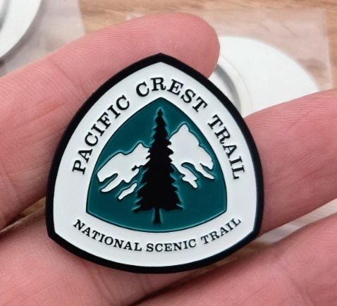
It's just a simple design of the PCT trail marker but it came out looking very nice!
Intentions & Goals
I read this book called 'Start With Why' with one of my previous coworker and I thought defining my "why"s for the trail will help tremendously. I know I will have really tough days and days when I want to just quit and go back to the comforts of society. Here is my unpolished "why" for the PCT that I memoed on my phone:
I am doing this for to remind myself that I can do anything I put my mind to. This year, my friend passed away and I was reminded that life is fleeting and I need to live pursuing what I want more vigorously. Postponing happiness until retirement is a flawed life approach! I've always wanted to this and I would like to take this time to figure out what I really want to do in this life and where I want to end up. I am trying to live with more intentionality and I'm working towards a real goal I've set for myself and doing this out of my own joy.
I am hiking the PCT because:
I need time to evaluate what I want to do with my life and career
The PCT has always been a larger than life adventure that I wanted to do
Life is short and I should take every chance I get to pursue what I want to do in life
I have the rest of my life to excel in my career
I want to experience true freedom and self sufficiency
I want to prove to myself I can do anything I set my mind to
Well here we go and I will try to post updates on my epic as I go :D
Happy Earth month! Go plant a tree 🌲
49 notes
·
View notes
Text

I’ve always thought this wooden bridge on the Pacific Crest Trail (PCT) is pretty interesting to look at. The bridge spans Squaw Valley Creek in Siskiyou County, California, USA. I captured this shot on a drizzly late October day as some autumn colors were still happening in the region.
The PCT runs north/south for 2653 miles all the way from Mexico to Canada through California, Oregon, and Washington. I once worked with a man who's hiked the whole thing (in multiple hikes). I probably only have about 2637 miles remaining before I can claim the same accomplishment.
In my Etsy shop: https://buff.ly/3wjUhOg
Prints and merch on demand: https://buff.ly/42CRYSG
#original photographers#photographers on tumblr#northern california#original photographic works#original photography on tumblr#siskiyou county#pacific crest trail#pct#hiking photography
18 notes
·
View notes
Text
Norovirus on the PCT . . . How an outbreak spreads along the trail
September 24
By Pien Huang for NPR
I was just corresponding with another PCT-hiking friend about the few times we have felt unsafe on the trail. All of our examples related, not to bears or rattlesnakes or even lightning (I might have included lightning had I thought about it more), to human encounters. A lost soul or two on the trail, hunters combining alcohol and firearms, a camping area near a road. Now here is another thing to worry about . . . norovirus. It is a good reminder not to abandon hygiene in the wilderness. RH

EIS officer Arran Hamlet walks into the Government Meadows site to conduct environmental sampling for norovirus.
Last September, Kevin Quinn was trekking through a remote, mountainous region in central Washington state, when he started feeling sick. "At first, I thought it was just a stomachache," he says, "But when we got to the campsite I started throwing up, and it started coming out the other end as well."
Quinn was on the trail with his daughter, who had left her job so they could hike together. After months of hiking, he found himself wiped out at a campsite in the middle of nowhere.
"I had heard about the norovirus for years, but it was always in the context of 'Oh, there's a cruise ship in the Caribbean,'" he says, "You don't think about this being an issue when you're out on the Pacific Crest Trail."
Norovirus is a highly contagious virus that can cause serious gastrointestinal distress for several days. It's often associated with enclosed, crowded settings like cruise ships, health care facilities and childcare centers.
But it also crops up in the wilderness – like in an outbreak among hikers like Quinn last year which was documented in a recent investigation by the Centers for Disease Control and Prevention.
Call in the disease detectives
After a stream of sick Pacific Crest Trail hikers came through the Washington Alpine Club Lodge near Snoqualmie Pass last summer, a volunteer named Robert Henry closed the dorm-style lodge and emailed health authorities.
"My concern at the time was to make sure that the hikers on the trail didn't get any worse, and to make sure that the volunteers at the Washington Alpine Club didn't contract whatever it was they were bringing in," Henry ways. He also worked to warn other hikers about the threat.

EIS officer Dr. Arran Hamlet observes a water source being tested for environmental contamination of fecal waste and norovirus.
Hamlet focused on a 70-mile stretch of trail south of the Lodge, where ill hikers were coming from. One common rest stop, he learned, was a remote log cabin in the meadows, with a pit latrine and a stream that's used for drinking water.
Hamlet and his team hiked out to the cabin and tested water from the stream. They also swabbed the toilets, the door handles, the tabletops, the poker chips – anything people were touching. While the water samples came back clean, "every single [surface] swab tested positive for fecal contamination," he says.
"This doesn't mean that we can see human feces on things," he adds, "but at some point in time, there was transmission of human fecal contamination onto every surface in the cabin we swabbed, and also everywhere in the latrine."
The results of the investigation were published this month in the CDC's Morbidity and Mortality Weekly Report. Investigators concluded that there was an outbreak of norovirus on the trail last summer that was spreading between hikers and that "exposure to contaminated surfaces within the cabin and ... latrines likely amplified transmission."
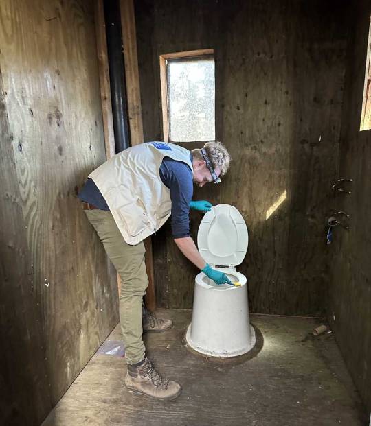
EIS officer Dr. Arran Hamlet swabs a backcountry pit latrine for norovirus sampling during an investigation for an outbreak of gastrointestinal illness among Pacific Crest Trail Hikers in 2022.
Shanna Miko, a nurse epidemiologist at CDC, was part of the field team on the Pacific Crest Trail study — and it wasn't her first norovirus-in-the-woods investigation. Last year, she traced an outbreak at the Grand Canyon, among people who were backcountry hiking and whitewater rafting.
"These are very well-planned trips. For many people, they're once-in-a-lifetime," she says. Travelers often read books and blogs in preparation, and get advice from others who have done the trip before them, accumulating trail wisdom – "places where people frequently stop, or places that have shelters where people frequently sleep over," good places to get water, or use the bathroom, she says.
These hubs, which seem so remote, see thousands of people – in varying levels of wellness – pass through in a season. They may not leave visible traces but some may leave germs, like norovirus, that can live on environmental surfaces for a long time, Miko says. (According to the CDC, this hardy virus can stay alive on surfaces for "days or weeks.")
Hand sanitizer doesn't cut and other advice for staying well
With norovirus, hand sanitizer and common water filters don't work. The virus is small, and "extra sticky" on skin, Miko says. And it takes just a few dozen viral particles to make a person very ill.
Miko says there are ways that hikers can cut their risks.
Always wash your hands with soap and water after you have a bowel movement – and wash them again before you eat. "The soap is a great detergent to remove the virus from your hands," she says. While any soap and water will work, she recommends biodegradable soaps in protected national parks and backcountry woods to reduce the impact on the environment.
Make sure to drink and cook with good, clean water. Pay attention to where the water comes from, and treat it properly. "Boiling for at least three minutes is the best way to kill everything you would typically come across," Miko says. And note: Most water filters are good at removing bacteria and common parasites but they don't cut it when it comes to norovirus. You'll need to layer on either chemical treatment or UV light treatment to kill the virus. (Here's the CDC's breakdown of what works for which pathogens.)
If you do fall ill, shelter in place if you can. This is for your own safety, and for the sake of others, "so you aren't seeding norovirus particles along the trail and putting others at risk," Miko says. This is not the time to try to push ahead but to rest and hydrate. "If possible, try to keep your defecation far from the trail and bury it, and don't prepare food anywhere near where you're using the restroom or vomiting," she says.
The worst of the symptoms usually passes in two to three days, though "you can still spread norovirus after you feel better," Miko says. She recommends waiting at least two days after symptoms have resolved before continuing on.
Norovirus was the last straw

Kevin Quinn set out to hike the Pacific Crest Trail with his daughter, Katie, who had left her job so they could hike together. Norovirus derailed their plans.
He was thirsty, he was really tired – and while he filtered the water, he skipped the additional, chemical treatment. Soon, he knew he'd made a mistake. "I was completely debilitated. I didn't have the energy to set my tent up," he recalls, "All I was doing was, like, every 15 minutes, going off into the woods and either throwing up or having diarrhea."
After a night of being very ill, Quinn and his daughter made a long, slow trek out of the woods. "We never made the whole trail," he says, "We just decided to call it quits."
Earlier in the summer, he caught COVID, which derailed his trail plans for a month. Up ahead, there were wildfires and trail closures. For Quinn, getting norovirus was the last straw.
A year later, he still regrets that he didn't take the time to treat the water properly.
To other hikers – he says: heed the signs, wash your hands and make sure your water is clean. In his experience, it's not worth the risk.
And, we would add, that water treatment options like the Steripen (using UV technology), would seem to be more effective.
9 notes
·
View notes
Text
Spending a Little Time out in the Wilderness

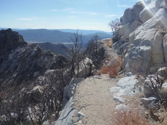
Earlier this week I had a chance to go do a little hiking so I chose to hit up an old favorite of mine: the Blue Ridge Trail as it leads up to the Pacific Crest Trail (PCT) just outside of Wrightwood in the Angeles National Forest.
The Blue Ridge Trail is a nice hike, but I do this one specifically to make my way to the ridgeline along which the PCT runs. The views from this location along the PCT are simply spectacular and the environment thru which you hike is pure foresty goodness.
My route took me a little under 7 and a half miles, and even though I'm a bit out of trail shape (exertion at altitude as opposed to sea level) I found I easily could have done 3 or 4 more miles fairly comfortably.
It is a spot I am sure to revisit relatively often as I want to spend more and more time hiking this section of the PCT.
The following is the route I took up the Blue Ridge Trail up to (and back and forth along) the PCT to soak up some of the views.
Let's go exploring.
#opt outside#nature#outdoors#no people#the hikers eye#landscape#go outside and play#landscape photography#nature photography#original photography#original photographer#hike#hiker#pacific crest trail#pct#explore
14 notes
·
View notes
Text
Pacific Crest Trail
16 notes
·
View notes
Last Seen Blogs
archivessamiesques
Archives Samiesques
highstreetreview
High Street Review

oh-so-bad
Your Entering My Dreams And Desires

brackendra
Knights of the Dawn

riotfuckery
Your friendly neighborhood big tiddy goth gf