#Atlantic concept
Text


Bugatti Atlantic concept
914 notes
·
View notes
Text

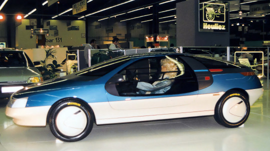
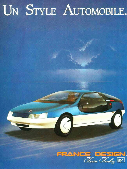


Heuliez Atlantic, 1986, by Henri Heuliez. A concept for a gull-winged coupé based on a Peugeot 205 GTi by the French coachbuilder. Presented at the Paris Motor Show, though the design was well received neither Peugeot nor any other car maker were interested in pursuing the project.
#Heuliez#Henri Heuliez#Heuliez Atlantic#1986#Peugeot 205 GTi#coachbuilt#concept#prototype#gullwing doors#futuristic#1980s#Paris Motor Show
179 notes
·
View notes
Text
[T]he Dutch Republic, like its successor the Kingdom of the Netherlands, [...] throughout the early modern period had an advanced maritime [trading, exports] and (financial) service [banking, insurance] sector. Moreover, Dutch involvement in Atlantic slavery stretched over two and a half centuries. [...] Carefully estimating the scope of all the activities involved in moving, processing and retailing the goods derived from the forced labour performed by the enslaved in the Atlantic world [...] [shows] more clearly in what ways the gains from slavery percolated through the Dutch economy. [...] [This web] connected them [...] to the enslaved in Suriname and other Dutch colonies, as well as in non-Dutch colonies such as Saint Domingue [Haiti], which was one of the main suppliers of slave-produced goods to the Dutch economy until the enslaved revolted in 1791 and brought an end to the trade. [...] A significant part of the eighteenth-century Dutch elite was actively engaged in financing, insuring, organising and enabling the slave system, and drew much wealth from it. [...] [A] staggering 19% (expressed in value) of the Dutch Republic's trade in 1770 consisted of Atlantic slave-produced goods such as sugar, coffee, or indigo [...].
---
One point that deserves considerable emphasis is that [this slave-based Dutch wealth] [...] did not just depend on the increasing output of the Dutch Atlantic slave colonies. By 1770, the Dutch imported over fl.8 million worth of sugar and coffee from French ports. [...] [T]hese [...] routes successfully linked the Dutch trade sector to the massive expansion of slavery in Saint Domingue [the French colony of Haiti], which continued until the early 1790s when the revolution of the enslaved on the French part of that island ended slavery.
Before that time, Dutch sugar mills processed tens of millions of pounds of sugar from the French Caribbean, which were then exported over the Rhine and through the Sound to the German and Eastern European ‘slavery hinterlands’.
---
Coffee and indigo flowed through the Dutch Republic via the same trans-imperial routes, while the Dutch also imported tobacco produced by slaves in the British colonies, [and] gold and tobacco produced [by slaves] in Brazil [...]. The value of all the different components of slave-based trade combined amounted to a sum of fl.57.3 million, more than 23% of all the Dutch trade in 1770. [...] However, trade statistics alone cannot answer the question about the weight of this sector within the economy. [...] 1770 was a peak year for the issuing of new plantation loans [...] [T]he main processing industry that was fully based on slave-produced goods was the Holland-based sugar industry [...]. It has been estimated that in 1770 Amsterdam alone housed 110 refineries, out of a total of 150 refineries in the province of Holland. These processed approximately 50 million pounds of raw sugar per year, employing over 4,000 workers. [...] [I]n the four decades from 1738 to 1779, the slave-based contribution to GDP alone grew by fl.20.5 million, thus contributing almost 40% of all growth generated in the economy of Holland in this period. [...]
---
These [slave-based Dutch commodity] chains ran from [the plantation itself, through maritime trade, through commodity processing sites like sugar refineries, through export of these goods] [...] and from there to European metropoles and hinterlands that in the eighteenth century became mass consumers of slave-produced goods such as sugar and coffee. These chains tied the Dutch economy to slave-based production in Suriname and other Dutch colonies, but also to the plantation complexes of other European powers, most crucially the French in Saint Domingue [Haiti], as the Dutch became major importers and processers of French coffee and sugar that they then redistributed to Northern and Central Europe. [...]
The explosive growth of production on slave plantations in the Dutch Guianas, combined with the international boom in coffee and sugar consumption, ensured that consistently high proportions (19% in 1770) of commodities entering and exiting Dutch harbors were produced on Atlantic slave plantations. [...] The Dutch economy profited from this Atlantic boom both as direct supplier of slave-produced goods [from slave plantations in the Dutch Guianas, from Dutch processing of sugar from slave plantations in French Haiti] and as intermediary [physically exporting sugar and coffee] between the Atlantic slave complexes of other European powers and the Northern and Central European hinterland.
---
Text above by: Pepijn Brandon and Ulbe Bosma. "Slavery and the Dutch economy, 1750-1800". Slavery & Abolition Volume 42, Issue 1. 2021. [Text within brackets added by me for clarity. Bold emphasis and some paragraph breaks/contractions added by me. Presented here for commentary, teaching, criticism purposes.]
#abolition#these authors lead by pointing out there is general lack of discussion on which metrics or data to use to demonstrate#extent of slaverys contribution to dutch metropolitan wealth when compared to extensive research#on how british slavery profits established infrastructure textiles banking and industrialisation at home domestically in england#so that rather than only considering direct blatant dutch slavery in guiana caribbean etc must also look at metropolitan business in europe#in this same issue another similar article looks at specifically dutch exporting of slave based coffee#and the previously unheralded importance of the dutch export businesses to establishing coffee mass consumption in europe#via shipment to germany#which ties the expansion of french haiti slavery to dutch businesses acting as intermediary by popularizing coffee in europe#which invokes the concept mentioned here as slavery hinterlands#and this just atlantic lets not forget dutch wealth from east india company and cinnamon and srilanka etc#and then in following decades the immense dutch wealth and power in java
24 notes
·
View notes
Text
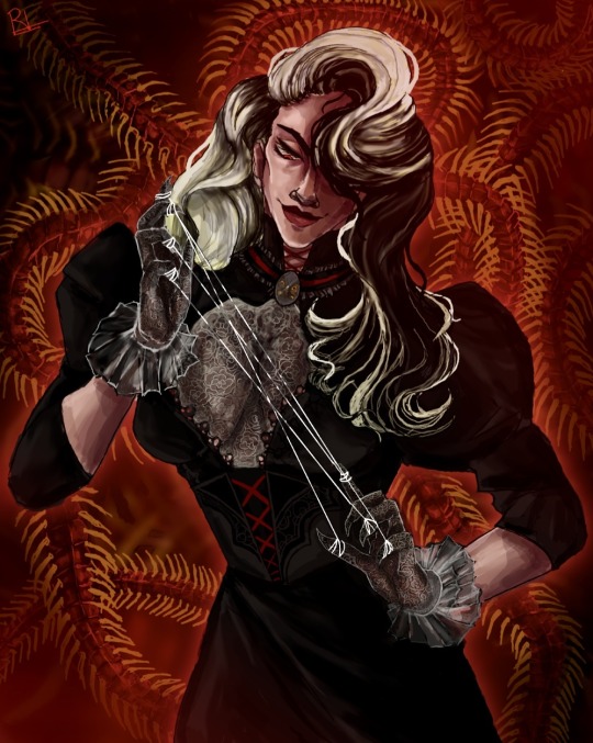
Was rewatching Black Butler and remembered a REALLY old character I made sooooo here is my demon bodyguard Carmilla >:D
#black butler#black butler characters#black butler oc#black butler book of circus#black butler demon#black butler book of Atlantic#kuroshitsuji#oc character#character concept#character design#demon character#black butler fanart#black butler fandom
32 notes
·
View notes
Photo
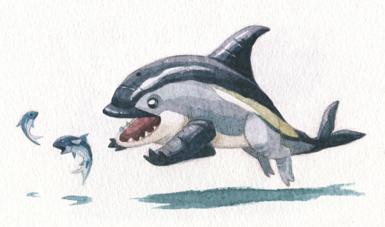
Atlantic White-Sided Dolphin pup - a small species of land cetacean often seen in large pods. These social creatures are known for their distinct markings.
#atlantic white sided dolphin#dolphin#cetaceans#land cetacean#illustration#illustrator#creature#creature design#creature art#character art#character design#sketchbook#moleskine#moleskin sketchbook#watercolor#watercolor illustration#watercolor painting#painting#concept art#marine mammals#deep sea life#marine animals#traditional art#fish#cetacean
167 notes
·
View notes
Text
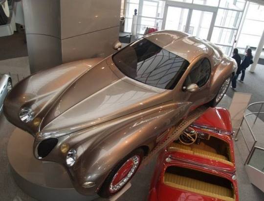
1995 Chrysler Atlantic Concept
The Walter Chrysler Museum's Amazing Cars Collection
#1995 Chrysler Atlantic Concept#car#cars#mopar#moparperformance#moparnation#moparworld#Chrysler Atlantic
34 notes
·
View notes
Photo
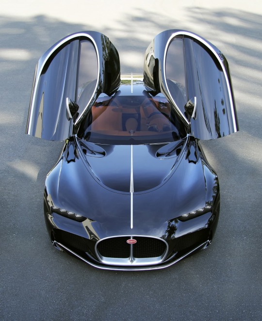


Bugatti Atlantic Concept
Bugatti may have only built three new cars in the modern era, the EB 110, the Veyron and the Chiron (all with their respective special editions), but designers at the Volkswagen Group's most interesting subsidiary have been working on other prototypes. The 1936 Type 57 SC Atlantic is one of the most beautiful cars ever made. Only four units were built, and only three of them are still alive. Logically, this is one of the most appreciated models by car collectors. And to honor that legacy that has been forged, Bugatti planned to show a reinterpretation of the two-seater at the Pebble Beach (California, USA) elegance contest in 2015. However, this project was aborted. Before reaching the final stage, the Volkswagen management decided to cancel it. The company put all its resources into the Chiron, which was publicly unveiled during the Geneva Motor Show in spring 2016. The Bugatti Atlantic Concept did not have the all-powerful 8.0-litre four-turbocharged W16 engine from the Chiron, but the V8 twin-turbo unit developed by Porsche and Audi. With 4.0 liters of displacement, this block has been squeezed to deliver 650 hp and 850 Nm in the Lamborghini Urus; also present in Bentley models such as the Continental GT.
57 notes
·
View notes
Text
guys.. guys.. tokyo ghoul! au megumi or next door neighbor! megumi im at a crossroads
#DO WE HEAD NORTH?? OR SOUTH???#i really want to participate in kinktober but ive been sitting on this tokyo ghoul crossover concept since my haikyuu days and i just#cannot finish it for the life of me#go go dancer is already 3k 😋#but the ghoul! megumi fic is themed after one of my favorite chase atlantic songs#and i.. just can’t decide#megumi fushiguro
2 notes
·
View notes
Text


feel.
(listen here)
#concept playlist#spotify playlist#spotify#moodboard#beige moodboard#aesthetic beige#the weeknd#chase atlantic#sza#two feet#hozier#khalid#new music#sam smith#<3
16 notes
·
View notes
Text
Are you telling me I missed a severe fandom drama between two pirates shows because I was literally on a boat? Aw man
#I'm sorry 'I was sailing the Atlantic' is forever going to be my very annoying new personality from now on#I don't even watch either the concept just seems funny#Only way to make it better would be if it was a ship war
5 notes
·
View notes
Text
found a bunch of old voice memos and this is the first time i've listened to my own voice and thought yeah it makes so much sense that people have loved this person . woah
#personal#i was singing a song under another song (saw my wings with the bodies in the gutter). there is someone else and i cant#recognise their voice . i think maybe i was drunk and maybe so were they . i have no idea who they are but their voice is so pretty.#i ask them if theyre ok and they ask if im sure im okay with this. and then they say see you soon and theres the sound of the door.#theres the voice of someone else after this too. they say listening to chase atlantic feels like sex . i have no idea who this person is.#this file is full of strings rising and falling. reverb of a massive space. some symphony inside interrupted by another symphony.#i remember laying on the floor of the orchestra hall to listen and to hide. i remember laying my hand on the floor and thinking i could#recognise this piece just by the way the ground vibrates.#i've been thinking a lot about mereology. sorry for not talking about nihilism the past week - everyone around me has been falling apart.#this month i have watched others be stricken by grief. the other side of the equation. one day i will create a poem about the way holes are#one whole part. the way disconnects are connected to the fabric of absence. (i saw your guts without the skin attached)#i could hear how in love i was when i asked the unknown voice if they would like some water. i blew out the candles and one stayed lit.#you don't need to tell me. forever and ever. strictly fall for academics and people with a passion. asked my mathematician about manifolds#and he asked me about his hair. i will wake up tomorrow if only it is to spend half an hour making tea. the concept of going to my country#is an oncoming train with a minute's delay. i told them i want to be their friend and they told me theyd like to meet up soon#and test how deep they can bite like good friends do. do you feel ashamed of my degree? do you feel ashamed of#your dry lips? skull fast-tracked to the floor. i have a jar of hand-picked dried damask roses for tea. ill tell you about k-theory until#you shut me up.
22 notes
·
View notes
Text
it's really funny seeing people say "the south is actually only these states:" and then go on to list wildly different states that basically cover the entirety of the u.s. that isn't the northeast, great lakes, or west coast.
none of these people are wrong exactly bc regions can be more than one thing, and regions often overlap. but it is funny that people fight about it.
#my concept of 'the south' has been shaped by living in florida#and to a certain extent maryland (the portion of the state that isn't below the mason dixon line tries to compensate-#-by being aggressively SouthernTM like bro you are mid atlantic just accept it)#but anyway my point is that places like texas or tennessee or even mississippi are super foreign to me#but they are still very much the south#just a wildly different flavor of it#i grew up on the shore and in swamp land#deserts and moutains and plains are not what i picture when i think of the south#but then i'll see smth in that setting and it's like oh yeah that too is the south lol#personal
2 notes
·
View notes
Text
Adam Sills’s well-written and beautifully produced Against the Map is in some ways a strange book to review [...] [from the disciplinary perspective of environmental studies]. Sills shows little interest in environmental history or ecocriticism, even in the “ecology without nature” mode [...]. His basic argument is that cartography, because of print capitalism, seeped into all sorts of facets of life on the British Isles during the late seventeenth and eighteenth centuries. It became something that playwrights, novelists, and creative nonfiction types, like Samuel Johnson, developed spaces of resistance to in their publications. Sills highlights the political nature and problematic historical genealogies of maps, an argument that has broader implications for [contemporary] environmental historians who use maps to convey [relatively more “objective” and/or “scientific” information] [...].
Sills begins by accepting the idea, derived from Ben Anderson’s comparative work, that “the history of the map and the history of the modern nation state are inextricably bound up with each other” (p. 1). He then cites two of the key analysts of this in relation to Britain: Richard Helgerson on the literary nationalism of the English Renaissance and John Brewer on the fiscal-military state of the eighteenth century, with its army of surveyors and excise tax collectors. In this historiography, the “surveyor emerges as an authorial figure,” key to the making of the modern state as distinct from traditional dynastic and ecclesiastical authority (p. 3). Combined with cheap printing, the result was what Mary Pedley has called a “democratization of the map” (p. 4). [...]
---
For John Bunyan, the “neighborhood” became a site of resistance (as it is for Denis Wood in his 2010 Everything Sings: Maps for a Narrative Atlas). [...]
For Aphra Behn, [...] the theater and “built environment” of the “fragmented, chameleonlike ... scenic stage” had the ability to challenge coherent representations of the Atlantic empire produced by maps like those of world atlas publisher and road mapper John Ogilby (p. 65).
From Dublin, Jonathan Swift directly satirized the cartographic and statistical impulses of the likes of William Petty, Henry Pratt, and Herman Moll, who all helped visualize London’s colonial relationship with Ireland [...].
From London, Daniel Defoe questioned efforts to define what precisely makes a market or market town through maps and travel itineraries, pointing toward the entropic aspects of the market (“its inherent instabilities and elusive nature”) that challenged and escaped efforts to stabilize such spaces through representations in print (p. 163).
Johnson’s travels to Scotland redefined surveying, resisting the model put forward by the fiscal-military state in the aftermath of the Jacobite Rebellion of 1745.
---
The final chapter and conclusion, “The Neighborhood Revisited,” looks at Jane Austen’s Mansfield Park (1814), a classic novel of the artificial environment of the estate garden. By the early nineteenth century, neighborhoods were more like gated communities and symptomatic of Burkean conservatism and nostalgia. But in Austen’s hands, their structures of affect also suggest the limits of the controversial map- and data-centric literary methodologies [...] and perhaps more broadly the digital humanities. “The principle of spatial difference and differentiation, the heterotopic conceit, always remains a formal possibility, not only at the margins of the empire but at its very center as well,... a possibility that the map cannot acknowledge or register in any fashion” (p. 234). For Sills, this is true of eighteenth-century mapping as well as the fashion for “graphs, maps, and trees” in the early twenty-first century.
---
Sills’s basic argument, that a certain canonical strain of English literature - from Bunyan to Austen - positioned itself “against the map,” seems quite solid. He makes this point most directly by appealing to the work of Mary Poovey on the modern “fact,” with the map as “a rhetorical mode ... that serves to legitimate private and state interests by displacing and, ultimately, effacing the political, religious, and economic impact of those interests” (p. 91).
Nevertheless, returning to a[n] [exclusively] canonical, Bunyan-centered, “small is beautiful” neighborhood approach [potentially ignoring planetary environmental systems, the global context, in cartography] seems limited and problematic from the perspective of Anthropocene [...]. The global maps and mathematics used by the likes of Edmund Halley and Isaac Newton, which were directly satirized by Swift in the Laputa section of Gulliver’s Travels (1726), did something different than Petty’s mapping of Ireland. High-flying as they may have been, such maps and diagrams were key to the development of [...] environmental thinking by Charles Darwin, Charles Lyell, Alexander von Humboldt, and others in the nineteenth century. More recently, global mapping [...], like the internet closely tied initially to the modern American fiscal-military state, have [also later then] been essential to identifying processes of climate change, ocean acidification, deforestation, dead zones, sea level rise, desertification, and a host of other processes that would otherwise be challenging to perceive. This is no mere “Vanity Fair.” Sills’s book would have benefited from engaging with Jason Pearl’s Utopian Geographies and the Early English Novel, published in 2014 [...]. Pearl also does close readings of Behn, Defoe, and Swift, choosing Margaret Cavendish instead of Bunyan and stopping in 1730, just before things became picturesque but just after they were financialized by the South Sea Bubble, Newton’s mint, and Robert Walpole. Pearl reproduces maps by Defoe of Robinson Crusoe’s global travels and of Crusoe’s island, Swift of Houyhnhnmland, Ambrosius Holbein of Thomas More’s Utopia [...].
What if rather than “against the map,” we are seeing struggles between radical and conservative cartography [...] engaged in a fight over the future (utopia)?
What if what [...] [some have] called “capitalist realism” [...], what might in the eighteenth century be called “nationalist realism,” is not the only thing happening with maps and the imagination?
---
Text above by: Robert Batchelor. “Review of Sills, Adam, Against the Map: The Politics of Geography in Eighteenth-Century Britain.” H-Environment, H-Net Reviews. May 2023. Published online at: h-net,org/reviews/showrev,php?id:58887. [Bold emphasis and some paragraph breaks/contractions added by me. In this post, all italicized text within brackets added by me.]
#hmm lot going on here pretty thoughtprovoking for a review#i have lots of thoughts about radical potential of maps for conception of planetary scale and antiimperialism#though simultaneously must remain critical of panopticon aerial perspective of satellite imagery as batchelor says originating with usempire#to acknowledge radical alternatives to imperial mapping in nineteenth century#instead of namedropping humboldt and darwin and chauvinist racist figures i wouldve pointed to#exslaves and abolitionists and their use of global scale conceptions to frame revolutionary atlantic and international solidarity#anyway#abolition#ecology#colonial
18 notes
·
View notes
Text
Identifying tolkien references in the wild, beginner level: “one ___ to rule them all”
Identifying tolkien references in the wild, more advanced: literally anything mentioning the long defeat
#it’s ALWAYS tolkien#Paul farmer... the band thrice... Ed yong in the atlantic yesterday...#I do like the long defeat concept it makes me insane but it sure says sth that it keeps coming up these days in a public health context :/#the long defeat#tolkien#skravler
11 notes
·
View notes
Text
There is one kid fic that simmers away in the back of my mind and its entirely about kaz trying to corrupt his pre school aged niece into being an appropriate heir to his criminal empire
#Like he has it in him to be a good dad he even more has it in him to be a horrible influence on other people’s children#The other concept of this draft that’s sooo important to me is background not particularly romantic very loving helnik#As one of those couples who like each other so much better. Now they’re divorced and don’t share a toaster or a house anymore#It’s what the Kaz versus zippy draft is about#My happy place#the other relevant details is that ketterdam = Atlantic city and the major parts of Kaz’s criminal empire#Are shilling time shares and suntan beds#He keeps trying to sell authentic goocci#And instructing his niece in cheating both poker and go fish.
8 notes
·
View notes
Text


This is my New Concept Art of the Main Characters of Amazing so-called World of Ebony Fox.
Note: And There I added Trivia too.
#amazing so-called world of ebony fox#new concepts#Main Characters#ebony fox universe#ora#gino paddley#professor atlantic#ebi dem universe#marine christina#Yaly#Deriston Hardy
2 notes
·
View notes
Last Seen Blogs

filmnight
wain

in-the-tardis-dont-blink
Superwholock

mintywolf
Oh, hello. It's you. :)

aph-poland
Eternal Flame

zhenxv-blog
borderline ;;