
ejeitraveldiaries-blog
Tourist Destinations in the Philippines
23 posts
Don't wanna be here? Send us removal request.
Last Seen Blogs

in-a-closet
Tsar Likes Tea🍵

purple-asphodel
Purple Asphodel

darkpi-evan
Art Dump Blog 💀

ragga-lox
Ragga Lox

leonathansoe
Leonathan Bratadikara
Video
0 notes
Text
Welcome to our website!
https://www.youtube.com/watch?v=jgFb4jGUqWU&feature=share
0 notes
Photo
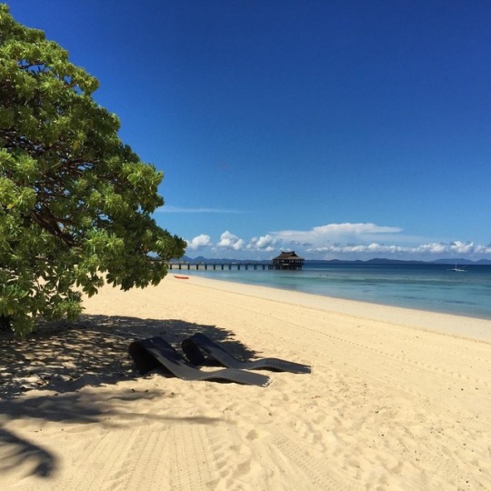
Balesin Island
Balesin is a mere 25-minute plane ride from Manila. It is located east of Mauban, Quezon beside the Polillo Islands and nestles at the gate of Lamon Bay, one of the richest, undisturbed fishing grounds in the Pacific. A true island paradise.Balesin Island, which is currently owned by Alpha Land, is a 424 hectare island resort located in Lamon Bay , Pollilio, Quezon Province, Philippines ; 25 miles of the eastern coast of Luzon , and 95 air miles, (approximately 30 minutes flight time) from The Ninoy Aquino International Airport in Metro Manila. The island is generally flat except for some elevated areas, (cliffs) which reach up to 6 meters above sea level. There is abundant vegetation consisting of rain forests, coconut trees, wild shrubs and flowers. White sand beaches, accentuated by coves formed by coral rock formations, surround Balesin Island.
Balesin’s most alluring spot is probably the spectacular Tordesillas Point: a wide, white beach strip that extends gracefully southward into a narrow neck that is- to a farther land mass by a permanent sandbar. At low-tide, the long flat sandbar appears like a rolling plain that connects the main isle to its insular neighbor-isle. But at high tide, the sandbar is covered over by the great Pacific Ocean-completely separating the far isle from the main, as if were an independent island. Meanwhile, the Pacific churns the surf more wildly on the southeastern side. (https://wayph.com/balesin-island-club/amp)
0 notes
Photo
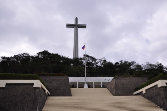
Dambana ng Kagitingan
One of the most famous landmarks in Bataan is the “Dambana ng Kagitingan” or the Shrine of Valor — perched atop Mt. Samat in Pilar — and was built to honor the bravery of the Filipinos and Americans who fought during the second world war.
The Shrine of Valor is considered to be Bataan’s icon. Its 92-meter gigantic memorial cross, and the marble colonnade where you can see the Bataan art mural engraved by Maximo Vicente, the glass mosaic designed by Professor Cenon Rivera, and all the artwork and sculptures majestically made by National Artist for Sculpture Napoleon Abueva.Located underneath the colonnade is the museum where you can see the remnants of war — including the weaponry, Japanese uniforms, miniature mountain landscapes, and some photos taken from the video documentation during the war.Your next destination would be the Mt. Samat Shrine — a 448-step zigzagging footpath through the bloodstone, which is said to be the rocks from Corregidor, stained by Japanese blood.
To get an amazing panoramic view of Bataan, there’s an elevator inside the Mt. Samat cross, which would take you to the viewing gallery encased in its arms.
The residents also said that Mt. Samat is the only place in the Philippines where you can get a perfect view of the sunrise and sunset. (http://primer.com.ph/travel/2017/09/06/dambana-ng-kagitingan-in-pilar-bataan)
0 notes
Photo

Hanging coffins at Sagada
For thousands of years, the people of the Cordilleras have practiced the tradition of burying their dead in hanging coffins, each suspended to the sides of the limestone cliff in Echo Valley in Sagada through ropes and strong wires. It is believed that hanging the coffins in such an elevated place will bring the physical bodies closer to their ancestral spirits. Elders or those who held high positions in the tribe are placed higher on the cliffs once they’re dead.
In their practice, the body of the dead is first bound with rattan and vines and then placed on a wooden chair facing the main door of the house to allow their relatives to pay respects. After a vigil for a number of days, the corpse is secured into a fetal position, the legs pushed up towards the chin. It is tied with rattan and vines and fitted into a coffin measuring only about a meter in length. Some of the coffins are also placed in the dark corners of the Lumiang Burial Cave.
It is also part of their tradition that the hanging coffins are reserved for only those who died of old age. Infants or those who died of illness cannot be placed inside the coffins in fear of bad luck. On the other hand, being subjected to a drop of blood coming from the wrapped corpse is considered good luck.
(http://www.choosephilippines.com/do/history-and-culture/3690/closer-heaven-hanging-coffins-sagada)
0 notes
Photo
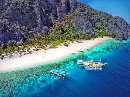
Coron
Coron is the third-largest island in the Calamian Islands in northern Palawan in the Philippines. The island is part of the larger municipality of the same name. It is about 170 nautical miles (310 km) southwest of Manila and is known for several Japanese shipwrecks of World War IIvintage. Because of its unique ecological features, it is entirely protected by several legal proclamations. Currently tourism is the top industry in Coron due to local beaches, dive sites, and other natural tourist spots. A dozen sunken Japanese warships at depths between 10 and 40 metres (33 and 131 ft) off Coron Island is a divingdestination, listed in Forbes Traveler Magazine’s top 10 best scuba diving sites in the world.
0 notes
Photo
Siquijor
Siquijor’s long-time reputation as a place of magic and sorcery both attracts and repulses visitors. Siquijor is also well known for its festivals that focus on healing rituals where incantations are sung while the old folks make potions out of herbs, roots, insects and tree barks.
Among the many attractions are the beaches, caves, waterfalls, Bandila‑an natural park and butterfly sanctuary. The most popular of them are the Cambugahay Falls and the old Balete tree, both located in Lazi.
The coral reefs ringing the island offer some of the best diving in the Philippines for snorkelers and scuba divers. Dive courses are conducted by several dive operators on the island in version of PADI, CMAS* and NAUI. Siquijor was declared a marine visitor arrivals among the three provinces in Region VII.
0 notes
Photo
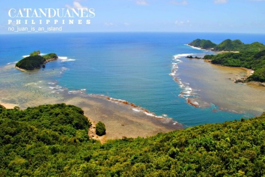
Catanduanes
The tourism industry in the province is growing relatively quickly despite the fact that the island experiences almost year-round typhoons, labeling the province as a “Typhoon Capital of the Philippines” with the tagline “The Land of the Howling Winds”. Catanduanes is known for its beaches, prehistoric caves, quaint stone chapels and massive churches. Despite the typhoons, safe anchorage is provided by its many bays and coves notably Kalapalan, Gigmoto, Soboc, and Cabugao. Its Pacific coastline attracts surfers, particularly at Baras. The province features beaches with fine sand and coral formations and several caves which include the Luyang Cave. The PAGASA Weather Radar Station offers panoramic views of the environs, while the Museo de Catanduanes has a fine collection of artifacts.The ideal time of the year to visit Catanduanes is from the months of March to August when the weather turns dry. It is coolest and rainiest from October to the early part of January, hottest from March to May. The tourism industry in Catanduanes continues to receive a positive response from foreign and domestic travelers, with the Provincial Tourism Office recording an increase in tourist arrivals by 15.89% in 2014 compared to the previous year. Based on the comparative data of travelers, 151,550 foreign and domestic tourists visited the island last year, or about 21,000 greater than the 2013 arrivals of only 130,766 visitors.
0 notes
Photo
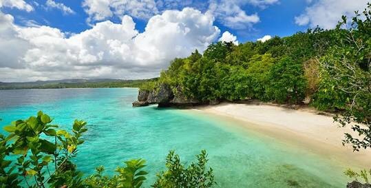
Apo Island
The marine habitat around the island is a marine reserve, protected by the National Integrated Protected Area Act (NIPA) and under the jurisdiction of the Protected Area Management Board (PAMB). It has become a popular dive site and snorkeling destination with tourists. There are two resorts on Apo Island, each with a dive center: Apo Island Beach Resort and Liberty's Lodge. There is also a ranger station and a lighthouse. Apo Island was a community-organized marine sanctuaries, and as such it has been well documented by the global science community.
At present, the island is home to over 650 documented species of fish and estimated to have over 400 species of corals. Most of the Philippines' 450 species of coral can be found here, from tiny bubble corals to huge gorgonian sea fans and brain corals. Visitors and tourists pay a fee to enter Apo Island and to snorkel or dive in the marine sanctuary there. These fees are used to keep the sanctuary clean and in good condition
0 notes
Photo

Mt. Mayon
Mayon also known as Mayon Volcano or Mount Mayon, is an activestratovolcano in the province of Albay in Bicol Region, on the large island of Luzon in the Philippines. Renowned as the "perfect cone" because of its symmetric conical shape, the volcano and its surrounding landscape was declared a national park on July 20 of 1938, the first in the nation. It was reclassified a Natural Park and renamed as the Mayon Volcano Natural Park in 2000.
From Mayon Volcano with its near perfect cone to white, golden and black sand beaches, waterfalls and caves, Spanish period churches and ancestral houses, Albay is home to scenic spots and majestic structures. The province is a complete destination for travellers who are after leisure, adventure, and new experiences.
0 notes
Photo
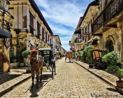
Vigan
Vigan is a city in the Philippines, on the west coast of Luzon island. It's known for its preserved Spanish colonial and Asian architecture. Calle Crisologo dominates the Mestizo district, with its cobblestone streets, malecón, horse-drawn carriages and rustic mansions. Near the white baroque Vigan Cathedral are Plaza Salcedo, offering fountain light shows, and Plaza Burgos, known for its street-food stalls.
Located on the western coast of the large island of Luzon, facing the South China Sea, is a UNESCO World Heritage Site in that it is one of the few towns left in the Philippines whose old structures have mostly remained intact, and it is well known for its cobblestone streets and a unique architecture of the Philippine colonial era which fuses Native Philippine and Oriental building designs and construction, with colonial Spanish architecture that is still abundant in the area, mainly the Bahay na Bato houses and an Earthquake Baroque church. Former Philippine president Elpidio Quirino, the sixth President of the Philippines, was born in Vigan, at the former location of the Provincial Jail (his father was a warden); he resided in the Syquia Mansion.
In May 2015, Vigan City was officially recognized as one of the New7Wonders Cities together with Beirut, Doha, Durban, Havana, Kuala Lumpur and La Paz. New7Wonders Foundation president and founding member Bernard Weber led a ceremony held at St. Paul Cathedral where he handed a bronze plaque to Vigan Mayor Eva Grace Singson-Medina, signifying the heritage city’s election as one of the world’s wonder cities.
0 notes
Photo

Baguio
Tourism is one of Baguio's main industries due to its cool climate and history. The city is one of the country's top tourist destinations. During the year end holidays some people from the lowlands prefer spending their vacation in Baguio, to experience cold temperatures they rarely have in their home provinces. Also, during summer, especially during Holy Week, tourists from all over the country flock to the city. During this time, the total number of people in the city doubles.To accommodate all these people there are more than 80 hotels and inns available.Local festivities such as the Panagbenga Festival also attracts both local and foreign tourists.
Baguio is the lone Philippine destination in the 2011 TripAdvisor Traveller's Choice Destinations Awards (Asia category) with the city being among the top 25 destinations in Asia.The Burnham Park, Mines View Park, Teacher's Camp, and Baguio Cathedral are among the top tourist sites in Baguio.
0 notes
Photo
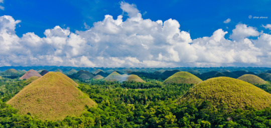
Bohol
Bohol is a province of the Philippines, in the country’s Central Visayas region. It comprises Bohol Island and numerous smaller surrounding islands. Bohol is known for coral reefs and unusual geological formations, notably the Chocolate Hills. On the main island, near the town of Carmen, these 1,200 or so symmetrical mounds turn cocoa-brown in the dry season, contrasting with the surrounding jungle's greenery.
The province is a popular tourist destination with its beaches and resorts.The Chocolate Hills, numerous mounds of brown-coloured limestone formations, are the most popular attraction. The formations can be seen by land (climbing the highest point) or by air via ultralight air tours.
Panglao Island, located just southwest of Tagbilaran, is famous for its diving locations and is routinely listed as one of the top ten diving locations in the world. Numerous tourist resorts and dive centers dot the southern beaches. The Philippine tarsier, amongst the world's smallest primates, is indigenous to the island.
0 notes
Photo

Banaue
The Banaue Rice Terraces are 2,000-year-old terraces that were carved into the mountains of Ifugao in the Philippines by ancestors of the indigenous people. They are frequently called the "Eighth Wonder of the World". Another thriving economy in the Banaue Rice Terraces is tourism. The Tourism industry has developed a number of activities for visitors which may include the traditional sight seeing of the terraces and visits to the tribes at the foot of the terraces. A Mumbaki (traditional Ifugao witch doctor) is also recommended to visitors, these doctors can perform spiritual healing rituals.
Domestic tourism however has gone down over the past few years. A contributing factor to this is the treatment of domestic tourists by the local guides in the area where it has been reported that local guides are more willing to entertain foreign visitors. The Batad Environmental Tour Guides Association (BETGA) in association with the Batad Baranguay authorities are currently laying a concrete track down from the Batad Saddle to the village proper. The park is featured on the reverse side of the 1985 series of the Philippine one thousand peso bill as well as the reverse side of the 2010 series of the Philippine twenty peso bill.
0 notes
Photo
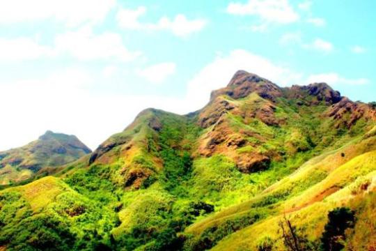
Mt. Batulao
If you are an assault lover and a beginner in hiking Mt. Batulao is best for you. It is just an hour away from Manila and located at Nasugbu, Batangas, which stands at 811 meters high. The cool weather of this mountain is a pleasant escape from the city, but if you hike during the month of March to October it is scorching hot. Mt. Batulao has old and new trial which gives you two options on which route you want to take Old to New or New to Old, but whatever trail you will choose the view can be the same which takes your breath away when you see the amazing overlooking view of Tagaytay and Nasugbu, Batangas.
0 notes
Photo
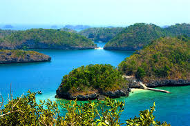
Hundred Islands National Park
The Hundred Islands is located in Alaminos, Pangasinan in northern Philippines. It is not totally composed of 100 islands, but 124 islands at low tide and 123 islands in high tide. The unique mushroom-like appearance and beaches draw a thousands number of tourist to this place. The Lucap Wharf was the entrance to the national park which is about 240km north of Manila.
0 notes
Photo

Kalanggaman Island
The island of Kalanggaman in Palompon has one of the most beautiful sandbars in the Philippines, and probably in the world. No wonder why international cruise ships made a stopover on this dream island to bring hundreds of tourists from the different parts of the world. Swimming in clear and translucent seawaters that glow at night, walking along a white long sandbar, and gazing at a billion stars at clear night sky are only some of the reasons why you should visit and return on this tiny island in 2016. Kalanggaman Island is a beautiful beach destination located in the municipality of Palompon in the province of Leyte. Kalanggaman is famous for its crystal clear water, white powdery sand and long sand bars stretching on both sides of the island. The surrounding of the beach is really calm, safe and truly relaxing thats why its suitable for family holidays or for short weekend trip.
0 notes